Esri has released a virtual reality (VR) solution for CityEngine, the company’s 3D modeling software.
The newest version of CityEngine allows urban planners, architects and GIS professionals to simply and quickly create VR experiences on mobile devices, the company says in a news release. These experiences can be viewed in the free ArcGIS 360 VR app from Esri Labs. Users can immerse themselves into 3D scenes by teleporting to static viewpoints and comparing different urban planning scenarios.
“We are pleased to see Esri add a mobile VR solution to its 3D smart city platform,” says Christian Huerzeler, project manager at the department of urban planning in Zurich. “By using ArcGIS 360 VR, our planning board and jurors can now study the impact of new architectural developments and urban planning scenarios from the perspective of pedestrians and citizens.”
Now, rather than relying on high-performance graphics computers and cumbersome wired VR accessories, having a simple smartphone paired with an affordable wireless headset is all that is required to be immersed in a VR experience.
“We greatly simplified the creation and sharing of the mobile VR experience,” says Dominik Tarolli, head of 3D geodesign at Esri. “In a matter of minutes, a CityEngine user can now create a VR experience out of a 3D scene and share it in ArcGIS Online, Esri’s cloud solution.”
CityEngine comes with many new additional features, including an OpenStreetMap-ready rule set, says Esri, who is offering a 30-day free trial.
A tight coupling of GNSS and inertial measurements is needed for both accurate and reliable positioning. The use of multi-GNSS is recommended to obtain a sufficient number of visible satellites in any outdoor environment.
We perform a joint GPS/GLONASS ambiguity fixing and a tight coupling of GNSS, 3D accelerometer, 3D gyroscope, 3D magnetometer, barometer and thermometer measurements. As GLONASS uses FDMA, double difference ambiguities are no longer integer-valued. We derive a transformation for the GLONASS double difference ambiguity term, that recovers the integer property and maintains a full-rank system. The obtained transformation maps the real-valued double difference ambiguity terms into integer-valued double difference ambiguity terms and a common single difference ambiguity term, that is treated as a real-valued parameter.
ANavS Multi-Sensor Module with GNSS receiver (green), 3D accelerometer/ 3D gyroscope and 3D magnetometer (red) and barometer (yellow). Photo: ANavS
Low-cost GNSS antennas cannot suppress multipath and, therefore, require an estimation of multipath errors. We provide a precise model for multipath that considers an individual amplitude, code delay, phase shift and Doppler shift for each reflected signal, and include it in our sensor fusion. The magnetometer measurements provide rough attitude information, which makes them very valuable for robust GNSS attitude ambiguity fixing.
We verified the performance of our sensor fusion in a test drive on a parking lot. The fixed phase residuals were in the order of a few centimeters for both GPS and GLONASS, which indicates a very precise position estimation. The proposed algorithms reduced the horizontal 95th-percentile error from 8.49 meters (for a standard GPS-only solution) down to 3.96 meters — a 66 percent improvement. In order to combine the GPS and VIO measurements as described in the last paragraph, the data need to be brought into the same reference frame. We develop a novel method to perform this change of reference frame. The proposed approach combines a quaternion reformulation of the problem together with a semidefinite relaxation technique.
The Open Geospatial Consortium (OGC) is considering start of a new work item for a Community Standard: Indexed 3D Scene Layers (I3S), and is seeking public comment on the work item proposal.
The I3S delivery format is used to stream 3D geospatial content to mobile, web and desktop clients.
I3S, initially designed by Esri, was publicly released in April 2015 as an open specification for streaming large, heterogeneous 3D geospatial data sets, including discrete 3D objects, large continuous meshes, 3D vector points, point clouds, and other content. I3S is designed from the ground up to be cloud, web and mobile friendly.
The I3S conceptual model is implemented using JSON. There is also an I3S Scene Service REST API specification for accessing I3S resources as endpoints. I3S is designed to stream very large 3D datasets and is designed for performance and scalability.
A document has been prepared that provides a justification to the OGC Technical Committee (TC) for consideration of I3S as a Community standard. This justification, along with the submitted candidate Community standard, will form the basis for TC review and vote to approve the start of the Community standard process.
Xsens has launched BASE, an online technology platform with a community forum and a knowledge base on 3D motion tracking technology and products.
On BASE.xsens.com, the knowledge base contains inside information about micro-electro-mechanical system (MEMS) sensors, inertial measurement units (IMU), sensor fusion algorithms, body-motion tracking and motion capture.
It also provides best practices, tips and tricks for the use of Xsens’ successful products the MTi series, the MTw and the MVN wearable motion capture solutions. A second section of BASE is the community forum with direct access to Xsens’ engineers and other Xsens users.
The knowledge base and community forum make it easier to integrate the MTi or MTw and to get the most out of MVN. If a question is not answered in the knowledge base, it is straightforward to ask a question to the community. With short response times from either other Xsens users or the entire Xsens engineering team, the user community is a quick way to continue development, Xsens said.
BASE is a next step by Xsens to support the growing community and interest in inertial technology. It further enhances the interaction between users and Xsens.
“Although Xsens makes it easy to use inertial technology in their applications, the underlying technology is complex and there are many features for specific applications,” said Remco Sikkema, Xsens marketing manager. “Understanding the technology makes it easier to integrate the products and be successful with Xsens.”
With BASE, engineers and engineering teams in the Xsens community can come closer together. The primary goal is to make Xsens customers more successful by providing a platform to exchange information.
There is no need to register for BASE to access the community forum and the knowledge base. To ask questions or comment on articles, registration is possible via SSO or email.
GeoMobile Innovations has released GeoBullseye for ArcPad version 2. GeoBullseye is a software extension that turns Esri’s ArcPad mobile GIS software into a high-accuracy GNSS, three dimensional (collecting X, Y and Z) solution supporting Esri workflows.
GeoBullseye supports accurate collection of positions and quality-control GNSS attributes for confident deployment in horizontal XY and vertical Z, including GEOID12 for accurate Mean Sea Level (MSL) elevations.
GeoBullseye displays real-time estimated accuracies on the ArcPad main map screen and supports automated recording of GNSS/GIS metadata, including key horizontal and vertical accuracy metrics and real-time differential correction status results.
Version 2 collects up to 35 configurable “auto” attributes to support confidence in critical field data-collection efforts. GeoBullseye is a XY and Z centimeter accuracy RTK GNSS collection solution that can be tightly integrated in a fully disconnected workflow with ArcGIS as well as connected, real-time synchronization with ArcGIS Online (AGOL) and/or ArcGIS Server including SDE environments.
“The high-accuracy GNSS 3D mobile GIS solution and can be deployed with today’s various Esri workflows,” said Geomobile Innovations President Richard Ash. “We recognize that centimeter-level GNSS data collection is a strong trend in mobile GIS and are excited to bring that capability to the Esri environment.”
Furthermore, GeoBullseye Version 2 implements a rigorous 14-parameter datum transformation to solve a critical horizontal datum shift problem for the specialized positioning needs of North American GPS users mapping in NAD83 (2011 epoch) datum while using satellite-based augmentation service (SBAS) such as WAAS or commercial services like Atlas, OmniSTAR, Terrastar and Starfire. Those services produce coordinates that are referenced to the ITRF08 datum, which is substantially different (greater than 1 meter) from NAD83/2011, the national standard in the U.S.
“Professional groups such as small and large utilities, engineering, land and natural-resource impact consultants and more are seeking confident collection of high-accuracy RTK horizontal and vertical positions and the ability to efficiently cycle this data to and from the field and update their GIS, perhaps when they return to the office or in real-time out in the field,” Ash said. “GeoBullsye for ArcPad is an easy-to-use solution that checks the critical ‘must-have’ boxes for organizations that want to streamline their field collection to GIS back-end workflows. It supports the key data elements necessary for reporting, and defending their horizontal and vertical GNSS data collection efforts.”
GeoBullseye V2 is priced at US$295.00. It is available for purchase through GeoMobile and authorized GeoMobile GNSS reseller specialists.
Topcon Positioning Group has released a new 3D dozer machine control system — 3D-MCMAX. The system is driven by dual IMUs (inertial measurement unit) designed to increase on-grade performance where speed and blade response is maximized, while eliminating the need for a mast on the blade.
The system uses Topcon 3D-MC2 technology with the dual IMU sensors and new, unique algorithms to deliver an integrated solution that locates the sensitive GNSS technology safely inside the cab instead of out on the harsh environment of the blade.
“The 3D-MCMAX is the next generation of dozer grading solutions that redefines the concept of machine control,” said Jamie Williamson, executive vice president and general manager of the Topcon Precision Automation Group. “It provides high-accuracy elevation, slope, and blade rotation sensing in an integrated configuration resulting in maximum speed, maximum control and maximum grading performance.”
The system is designed to let operators work confidently in rough or fine grade applications, slope conditions, and in restricted sight environments without the visual obstruction of masts or risks to hanging cables.
“This advanced system is a result of our clear understanding of how technology is driving the evolution of the construction world, and focusing our improvements on smart algorithms in our firmware and software to increase the productivity of the hardware — a full systems approach,” said Williamson. “The added bonus is a clean integration onto the equipment. Gone is the need for daily installation and removal of antenna, cables, and mast. With 3D-MCMAX, the operator just climbs on and gets to work — downtime is minimized.”
REAL 2015: Capture, Compute, Create will be held Feb. 25–26 at Fort Mason Center in San Francisco. REAL is designed to explore the professional 3D sensing, creation, and visualization industries. It includes an executive summit and a world’s fair of cutting-edge 3D demonstrations, and is organized by Autodesk.
According to organizers, “From drones to autonomous cars, industrial robots to major engineering works, and game consoles to tomorrow’s mobile phones, 3D sensors are suddenly everywhere. And several decades after first grabbing headlines, VR and 3D printing are hot again, attracting billions in investment, and moving beyond early adopters to professionals. But it is the sum total, where sensing meets making, where big change is brewing.”
Sponsors include Leica Geosystems and Topcon. Two Topcon experts will speak at the event: Jason Hallett, Topcon vice president of global product management, and Eduardo Falcon, executive vice president and general manager of the GeoPositioning Solutions Group.
“The Topcon line of advanced 3D imaging and mapping technologies are designed for a wide range of geospatial applications providing data-rich results,” Falcon said. “REAL 2015 presents opportunities to explore how our mobile and static scanning solutions can be utilized in forward-thinking ways, as 3D sensing and reality capture continue to permeate traditional and non-traditional industries alike.”
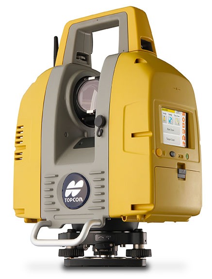
Topcon Positioning Group announces the release of the newest edition to the GLS line of laser scanners, the GLS-2000. Featuring an expanded field of view, the GLS-2000 is designed to pair with ScanMaster v3.0 software for quickly capturing and processing 3D point-cloud data.
“The GLS-2000 is the fastest and most versatile scanning system in its class,” said Charles Rihner, vice president for the Topcon GeoPositioning Solutions Group. “With a scan range of more than 350 meters, the GLS-2000 is capable of accurately capturing long-distance measurements in applications where access is limited due to safety or logistics concerns.”
Using Topcon Precise Scan Technology II, the GLS-2000 is designed to emit pulse signals three times faster than earlier models. “Using faster pulse signals enables timing to be detected more precisely, which results in reduced noise and higher-accuracy data,” said Rihner.
“With the on-board control software, scanning can simply be started with the touch of a button. Even entry-level users can intuitively operate the GLS-2000 that comes complete with a color graphical display,” said Rihner.
Additional features include a full-dome scanning range, user selectable Class 3R or 1M laser, and an exclusive laser plummet function that measures instrument height with a one-touch operation.
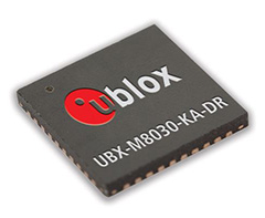
u-blox has introduced its next-generation semiconductor technology dedicated to advanced in-dash navigation, emergency call (including eCall, a European rapid response initiative, and ERA-GLONASS, Russia’s Government Accident Emergency Response System), usage-based insurance, road-pricing, and stolen-vehicle recovery systems.
The UBX-M8030-Kx-DR chip integrates 3D Automotive Dead Reckoning (3D ADR) technology, which enables it to calculate a vehicle’s position, speed, and elevation in areas of poor or no satellite visibility, a common scenario in high-density urban environments, stacked highways, or parking garages.
Here is a two-minute YouTube video demonstration.
“Drivers expect car navigation systems to be fast, accurate, and work everywhere, regardless of satellite visibility. As cities expand, construction of more tunnels, multi-level overpasses and park garages is increasing,” said Thomas Nigg, VP Product Marketing at u‑blox. “Our solution meets this challenge head-on; regardless of satellite visibility, our 3D ADR chip shows movement in three dimensions to maintain continuous and accurate positioning in tunnels, stacked highways, multi-level or underground parking facilities.”
The technology aids traditional GNSS navigation systems such as GPS, GLONASS and BeiDou by blending them with individual wheel speed, gyroscope and accelerometer information to maintain accurate 3D positioning even when satellite signals are completely lost.
The UBX-M8030-Kx-DR chip is self-calibrating to compensate for sensor aging and temperature effects. It is compatible with virtually all vehicles and drive trains (i.e. front-, rear-, all-wheel drive), and supports a variety of sensor combinations. Sensor information can be derived from the vehicle’s sensors for the most cost-efficient implementation, or from external sensors for after-market solutions. The chip is AEC-Q100 qualified and is produced in ISO/TS Automotive certified production sites.
The chip requires minimum host integration or customization resulting in no risk, low cost, and fast time-to-market, u-blox said. Installation is uncritical thanks to automated software calibration. 3D ADR is accurate even at low speeds.
The chip allows for easy testing, simple and modular production set-up, and minimal BOM. The chip comes in a 40-pin QFN package measuring only 5 x 5 mm and includes I2C, SPI, UART and USB interfaces.
While the Esri Survey Summit still struggled to find a way to attract attendees, the International User Conference exploded by blowing away last year’s attendance by attracting a record 16,000+ GIS’ers this year in San Diego.
The Survey Summit reeled in only ~250 people this year along with a roomful of exhibitors. That’s not to say the content wasn’t good. On the contrary, the content was very good, as it usually is. However, state/regional conferences seem to be gearing up so it’s difficult to see how a national conference like the Survey Summit can offer enough superior content to entice people to spend a few days and a lot of dollars traveling to San Diego during prime field season.
Further complicating the issue is the fact that ACSM/NSPS is likely not going to participate in next year’s Survey Summit. But, the Survey Summit will survive because Esri will continue to sponsor it, and there’s a select few of us (yes, I’ll likely attend next year) who see the value of networking with the others who are like-minded.
Highlights of the Survey Summit
The opening ceremony featured Esri’s Donny Sosa playing the “Star-Spangled Banner” on an electric guitar.
But Donny wasn’t playing just any electric guitar. It was an Atom 3D “printed” guitar made by 3D Systems. Folks, 3D printing is going to be mind-blowing technology of the future. It will be like everyone having a machine-shop in their home/office. Design a part or a system on your home computer and manufacture it using your 3D printer (or a local 3D printing service).
Aside from the 3D printing entertainment, three subjects stuck in my head from the Survey Summit:
1. UAVs (Unmanned Aerial Vehicles) for mapping
I think the presenter from Hawkeye UAV said it best. Paraphrasing, he said that UAV commercial operations aren’t a major issue in any country besides the U.S. In the U.S., of course, commercial operations of UAVs are still prohibited. Only universities and government entities that are granted a CoA (Certification of Authorization) from the Federal Aviation Administration (FAA) are allowed to operate UAVs. The requirement for a CoA isn’t to be taken lightly, either. Last week, the Oregon Department of Fish & Wildlife was shut down from deploying a mapping UAV because its FAA paperwork wasn’t in order. They were planning to use an inexpensive RiteWind Zephyr II modified by Embry-Riddle University.
If you recall, a bill was passed earlier this year with a provision to integrate UAVs into the U.S. National Airspace System (NAS) by 2015. This is going to be a challenge for the FAA, and you can expect some pretty tight regulations being applied to UAV operations. Imagine paparazzi circling UAVs over Hollywood snapping photos of celebrity sunbathers. Some people speculate that UAV operators will be required to be licensed pilots, even if they aren’t actually flying the UAV (UAVs have pre-programmed paths they follow). The rationale is that UAV operators may need to communicate with Air Traffic Controllers to ensure there is a safe distance from other aircraft.
Although there are UAVs being designed and built specifically for mapping such as Gatewing (recently acquired by Trimble), there are an increasing number of low-cost and do-it-yourself UAVs such as Event 38 and others. In fact, I was speaking with one university researcher who operates UAVs. He said that for navigating one of his UAVs, he actually places a GPS-enabled mobile phone inside the UAV. The mobile phone, with a u-blox GPS chipset, is used to navigate the UAV as well as receive GPS corrections from mobile phone network. The only missing link from him obtaining reeeeally good accuracy was an external antenna (no such luck on a mobile phone), but he said the accuracy was still usable, and very affordable.
GPS World has published several articles lately on UAVs that you may be interested in reading.
Although I hear people say they don’t take UAVs seriously, I think it’s a serious technology with a lot of potential. Hawkeye UAV, which I mentioned earlier, says it is as busy as ever performing a lot of stockpile (volume) measurements in mines. That’s just one of many apps for this low-cost, fast, and easy-to-deploy technology.
2. 3D Rendering Technology
I’ve written before about 3D rendering technology; remember this cool Ted video? It’s worth watching.
Last year, Esri acquired a company called Procedural, which is the developer of a product named City Engine. It’s a really neat tool for “building” a city, from scratch if you wish, to help people visualize (in 3D) what a proposed development would look like. I’ve done similar things in the past with Autodesk’s 3D Studio Max, but City Engine seems to be a more quick-and-dirty, GIS-centric tool. Take a look at the following video on how to build a city from scratch into a complete 3D visualization:
3D visualization tools have been progressing slowly over the years, but I think it’s getting to the point that without a lot of expertise, one can generate high-quality 3D visualizations. The trend is clear. If you recall, Trimble acquired Sketchup from Google earlier this year to incorporate a 3D visualization toolset inside its software. Geospatial specialists are getting closer and closer to being able to produce video-game-quality 3D renderings for visualizing everything from land development to regional watersheds and environmental impact areas. It’s a fantastic tool for presenting rich, complex geospatial data to the general public.
3. The Cloud
Ok, cloud-based apps aren’t anything new. In fact, I’m writing this article using a cloud app. Microsoft has had a cloud version of Office apps for years.
It seems Esri has retooled its entire corporate strategy around cloud-based apps and data. It’s not just www.arcgis.com, Esri’s new cloud app for GIS, or ArcGIS for Android/iOS/Windows Mobile for mobile devices. According to Esri president Jack Dangermond, Esri has spent “tens of millions” on acquiring/licensing content (data) for cloud users. It’s not just vector data either (roads, etc.). In the U.S. arcgis.com subscribers will have access to nationwide 30-cm resolution imagery. In Europe, subscribers will have access to 60-cm resolution imagery, while subscribers in the rest of the world will have access to 1-meter imagery.
The upside of cloud apps is that users can offload the IT overhead part of GIS, which can be frightenly expensive and complex. It also makes GIS apps easier to deploy because there is no client software to install or maintain on users’ computers.
However, cloud GIS is not the solution to every GIS challenge. Even Esri president Jack Dangermond openly stated last week that “You don’t have to buy this, but you should,” referring to arcgis.com. But make no mistake about it, he’s clearly pointed the Esri ship to the cloud. My gut tells me that with arcgis.com, Esri will be successful in introducing GIS apps to a much broader audience, seemingly in line with Dangermond’s vision that eventually GIS will evolve from a scientific tool to a tool used by general society.
Courtesy: ESRI
On the subject of bringing GIS tools to to general public, Esri announced Esri Maps for Office, which Esri describes as an analytics tool to “visualize data by creating and sharing interactive maps directly within Microsoft Office.” In other words, make maps based on your Excel (or other Office) data. Take a look at the video below to gain an understanding of what Esri is talking about.
If you’d like to see some brief comments that I tweeted from the Survey Summit on some other interesting items, click here for a quick summary. In next week’s newsletter, look for my summary on the Esri User Conference.
Geosoft announced the availability of its 2012 Software Release, including updates to Oasis montaj, Target, Target for ArcGIS and GM-SYS Modelling software, and the new release of Geosoft VOXI Earth Modelling, a geophysical inversion software service that generates 3D voxel models from airborne or ground gravity and magnetic data. The 2012 release includes major 2D and 3D workflow enhancements and new capabilities that deliver greater efficiency and flexibility for resource explorers and earth scientists exploring the earth’s subsurface.
“Each year Geosoft has continued to make improvements in developing our software technology to support explorers challenged to visualize and analyze more complex structures, deeper under cover, within integrated interpretations,” says Louis Racic, Geosoft Product Director. “The 2D to 3D workflow is an important one to get right, and a particular challenge for geoscientists working across GIS and exploration software platforms. Bridging the gap between 2D and 3D is a key improvement area within our 2012 Software Release.”
Release highlights
According to the announcement, new capabilities and workflow improvements in the Geosoft 2012 Software Release help save time and provide greater flexibility when visualizing multidisciplinary geoscience data in 2D and 3D.
Improved 2D to 3D workflows in Target for ArcGIS: The 2D to 3D workflow enhancements, include new display capabilities, and new section import and export options. Layers, such as interpretation layers from sections or plans can now be easily displayed in their correct geospatial orientation within your 3D view. 2D section interpretations can be exported to a 3D georeferenced file, such as shapefiles or DXF files, to be shared with other 3D applications. 3D vector files, such as open pit outlines, and wire frames can now be easily imported to multiple section and plan maps.
3D Viewer improvements: Geosoft 3D gridding methods have been expanded to include IDW and direct gridding; these new methods better support the 3D gridding of a broad range of data types. Angled clipping of objects in 3D views provides the ability to clip parallel or perpendicular to dataset orientation or geological strike. Geoscientists can set a clipping plane that aligns with any direction chosen.
Expanded GM-SYS 3D density model support: Voxels can be used to define the 3D density variation within GM-SYS 3D model layers. This provides more direct integration with 3D seismic data as the generated density cubes may be used directly in the GM-SYS model.
BING Maps imagery: Geoscientists can now add satellite imagery to their basemaps by connecting to the Bing Maps online data source. This is a useful, additional data layer which provides geographic context to maps.
VOXI Earth Modelling
Geosoft VOXI Earth Modelling is a new geophysical inversion software service that generates 3D voxel models from airborne, ground gravity and magnetic data. VOXI Earth Modelling is accessiblewithin Geosoft Oasis montaj and uses the power of cloud computing to rapidly invert large exploration datasets. More information on VOXI Earth Modelling is available at www.geosoft.com/voxi.
Release availability
Online installation of the Geosoft 2012 Software Releaseis available within Geosoft software and from the Downloads page within the Geosoft online support centre. Information on how to request an update DVD is available in the Geosoft Support Knowledge Base.
Intergraph released SmartPlant FreeView, a free .VUE viewer that allows users to display and navigate Intergraph 3D models and view associated plant properties.
According to the announcement, SmartPlant FreeView will open any Intergraph SmartPlant 3D and SmartMarine 3D projects published as a .VUE file. A user then may walk through the plant, ship or offshore model and select any object in the view to see its associated plant properties via the MDB2 package. Intergraph’s SmartPlant Review Publisher can convert and combine SmartPlant 3D and SmartMarine 3D, as well as other project types, into .VUE and MDB2 formats for viewing with SmartPlant FreeView or Intergraph’s full-capability visualization solution, SmartPlant Review.
Intergraph reports that the free .VUE viewer has a complete set of on-screen navigation controls for easy use, allowing even the most casual user to walk through complex 3D models with no training. Keyboard navigation is equally simple. An orientation axis is displayed in the view to help the user maintain direction. SmartPlant FreeView also has a surface measure command to display accurate distances between objects.
Vlad Savulian, engineering systems lead for AMEC Natural Resources and one of the many industry experts who worked with Intergraph on the requirements for a free .VUE viewer, said access to SmartPlant FreeView will benefit companies of all sizes, especially those collaborating on mega-projects.
“On the oil sands projects in Canada, AMEC works with a large number of clients, partners and subcontractors who could benefit from viewing the 3D model,” Savulian said. “With SmartPlant FreeView, they will be able to easily navigate the plant model, view properties, make comments on what they see or ask questions about what they don’t understand. With the introduction of SmartPlant FreeView, we will be able to extend model review capabilities to a much broader audience.”
Gerhard Sallinger, Intergraph Process, Power & Marine president, agreed: “SmartPlant FreeView enables our customers and their suppliers to increase productivity and competiveness without increasing costs. The use of SmartPlant 3D and SmartMarine 3D has doubled in the last two years. With that tremendous growth comes the need for a variety of users, including design, engineering, construction, operations and maintenance, to view these complex 3D models.
“Now, for example, an engineering company can provide a 3D model to a potential subcontractor who can use SmartPlant FreeView for a preliminary review and bid based on the actual model rather than a collection of drawings – without having to purchase viewing software,” Sallinger said. “Then once the work is awarded, the subcontractor can upgrade to SmartPlant Review for more in-depth review and analysis capabilities.”