MicroSurvey Software, part of Hexagon, has released its new field data-collection software platform for Android users.
FieldGenius for Android, version 1.0, is first release of the company’s new multi-platform field software built on the Android platform. It supports most popular GNSS sensors on the market today.
FieldGenius is third-party, brand-neutral data-collection software used by many surveyors. The new release builds on decades of innovation MicroSurvey has invested into the original FieldGenius software, providing users with an easy-to-use and intuitive mobile data-collection software package for the next generation.
New features include dynamic data panels synchronized with the map views. A fresh user interface provides familiarity for existing FieldGenius users while offering new tools, simplified workflows and readily available data that surveyors require at the point of work to make informed decisions in the field.
“Surveyors, dealers, and distributors from every corner of the world have been demanding an Android based version of MicroSurvey FieldGenius for years,” said Marc Veinotte, global sales and OEM manager at MicroSurvey. “This is the first release of our new multi-platform field data collection software that will provide a consistent user experience across a wide cross section of data collection devices. MicroSurvey continues its hardware neutrality strategy offering support for almost every brand of popular and upcoming GNSS receiver on the market today.”
Early adopters of FieldGenius for Android will receive additional benefits and participate in the newly created MicroSurvey Technology Innovation Group (MTIG).
Trimble’s Rachel Blair Winkler offers an overview of Trimble’s Catalyst On Demand, a usage-based service plan for Android phones and tablets for the company’s Catalyst GNSS receiver, at the 2019 Esri User Conference in San Diego.
Trimble Catalyst On Demand enables automated domain-level email address access, which streamlines license allocation for organizations with a large number of users. (Photo: Allison Barwacz)
Trimble’s Catalyst software-defined Global Navigation Satellite System (GNSS) receiver for Android phones and tablets is now available with a usage-based service plan: Trimble Catalyst On Demand.
According to the company, the new service plan is focused on satisfying the requirements of a growing number of industries and organizations who recognize the benefits of using high-accuracy GNSS technology in the field, but need a more flexible payment model.
Trimble Catalyst On Demand provides scalable access to RTK-quality GNSS positioning using an affordable pay-per-use hourly pricing model in addition to the current Catalyst monthly plans, the company added. The service also enables automated domain-level email address access, which streamlines license allocation for organizations with a large number of users.
“Catalyst On Demand is Trimble’s response to the growing number of individuals and organizations needing flexible access to high-accuracy GNSS technology,” said Rachel Blair Winkler, business area manager, mapping and GIS, for Trimble. “By providing a usage-based payment model for Catalyst, we are empowering more users inside and outside the geospatial profession to record positions, navigate to points, measure relative distance and create digital maps. This results in better work and better decisions.”
Trimble Catalyst service subscriptions and the Catalyst DA1 antenna are available through Trimble’s Authorized GIS Distribution Network.
CHC Navigation has launched its LT700 rugged Android tablet. The LT700 is designed to increase the efficiency and productivity of the mobile workforce in different industries and applications.
An integrated GNSS module (GPS/GLONASS/BDS/SBAS) provides robust positioning performance. The LT700 dual-SIM 4G modem ensures fast and reliable connection with mobile teams.
The LT700 tablet features an 8-inch sunlight-viewable touchscreen. It displays geospatial information system (GIS) data tables, complex vector and raster maps, or high-resolution pictures in direct sunshine and high-bright areas, CHC Navigation said.
Unlike consumer-grade tablets, the L700 is intended for mobile field workers. Its industrial IP67 design withstands all-day use in harsh environments and conditions, and is protected from dust, rain, extreme temperatures and accidental drops from 1.2 meters. Rugged design, soft corner bumpers and long battery life provide the LT700 with the capability to perform uninterrupted for a complete working day.
The LT700’s octa-core 2.2-GHz CPU supports running large maps and datasets without any lag or slowdown. Driven by Android 8.1 and bearing the GMS (Google Mobile Service) certification, the LT700 runs seamlessly the most common professional data collection applications available from the Google Play store.
BRING YOUR OWN DEVICE (BYOD) is not just an industry buzzword. It can change the way professional surveyors work every day. The idea of using a smartphone or tablet instead of a dedicated device is appealing. But is it good enough?
Surveyors and mappers are challenged with the arduous task of data collection that meets accuracy and precision standards and provides adequate attribute information for the project. Before the invention of the electronic data collector, handwritten notes in field books were the norm. Every note keeper’s style varied in content, neatness and thoroughness. Calculations for determining survey data values were completed longhand on paper and were very time consuming.
Like its personal computer counterpart, the electronic data collector was introduced in the late 1970s with minimal adoption by the average surveyor because of cost and complexity. Storage methods for the era included magnetic modules and tape; both forms of media were expensive and fragile with little storage for the cost.
Data collection was limited to numeric values only, with horizontal and vertical angles, slope distance, point number and point code being the extent of the information. Couple this process with the limited availability of printers and plotters capable of depicting the data for the surveyor’s use, and one can see why few practitioners invested in these systems.
iOS aerial viewer. (Screenshot: Tim Burch)
The 1980s and 1990s brought significant changes to surveying with the advancing technology of electronic computing and measuring. The introduction of robotic total stations, various methods of GNSS, and even leveling took advantage of significant computer power and measuring processes, and the data collector stayed in lockstep with the advancing instrumentation. Almost every equipment manufacturer developed their own proprietary data collector and software system because of the unique design and programming of their systems.
In the 2000s and later, third-party manufacturers began producing data collectors with advanced computing power and the ability to connect to varying brands of equipment. Most of the programming for these collectors are still proprietary in nature to this day.
Also during the 2000s, a new wave in mobile communications was taking place. Cellular phone and data signals were now being used to transmit an abundance of information between users.
The rapid development of handheld communication devices has led to the meteoric rise of two specific mobile operating systems: one by a radical startup that concentrated on dominating the search engine market, and the other by an avant garde computer company looking to expand its unique customer base.
By the end of the decade, the world had been introduced to the Android operating system by Google, and the iOS operating system by Apple. The combined market share for the two operating systems at press time was just under 98 percent of all mobile devices worldwide.
Trending Away from Proprietary Data Collectors
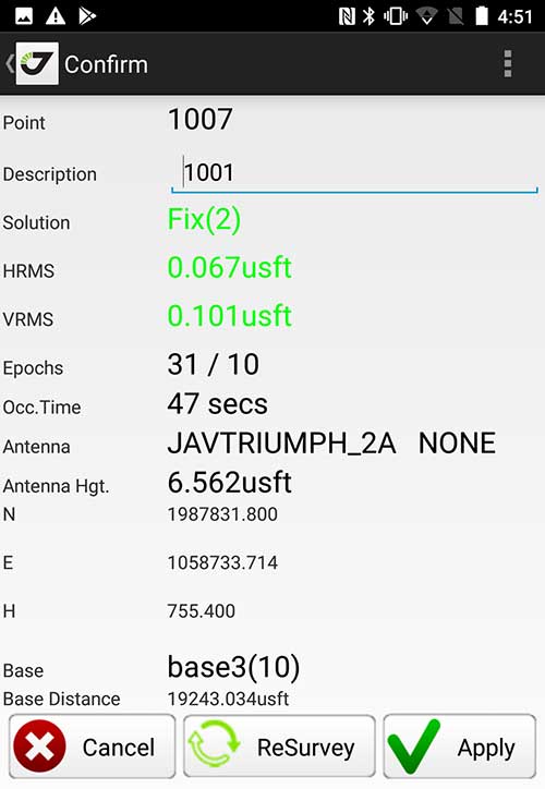
Android Point Info: Confirmation of collected data, including equipment and base station. (Screenshot: Tim Burch)
Because data collection by surveyors and mappers have traditionally been performed on proprietary systems designed and produced by equipment manufacturers for use with only their instruments, these collectors, while very powerful and robust, are costly for the equipment manufacturers to produce because of the limited market of surveyors and mappers.
Many suppliers, before the introduction of the iPhone and Android operating systems, attempted to adapt their data-collection platforms to wider recognized mobile operating systems (for example, Windows CE/Pocket PC/Mobile) on a bevy of mobile devices (HP/iPAQ, Sony Eriksson, HTC) with little success. Various versions of Windows are still being used today by GNSS equipment manufacturers’ proprietary data collectors, including Trimble, Hemisphere GNSS, Topcon and CHC Navigation.
However, the field of operating environments has become more crowded as technology continues to advance. The proliferation of Windows-based data collectors are now on the decline.
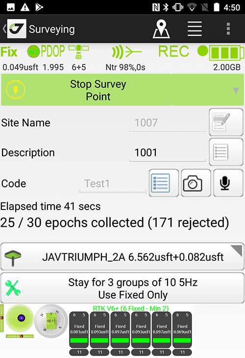
Survey Point: Status of survey data collection and GNSS engine signal reception. (Screenshot: Tim Burch)
Enter Android and iOS. Driving the decline of the previously popular Windows mobile platform is the rapid adoption of the iOS and Android operating systems. These two environments have also led to a substantial number of devices and applications for users.
Part of the reason for the speedy acceptance of the devices and operating systems has been the ease of programming. It is estimated that each operating system has more than two million applications in their respective online stores, with more being introduced daily.
Because of the proliferation of smartphones, nearly everyone is familiar with the look, feel and operation of touchscreen devices and their various applications. This familiarity is driving a new trend in data collection: the concept of “bring your own device” (otherwise known in IT security circles as “BYOD”). BYOD is being introduced by several surveying and mapping equipment manufacturers as an alternative to their proprietary data-collection devices.
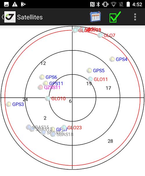
Sky Plot: Where the ‘birds’ are in the sky. (Screenshot: Tim Burch)
These manufacturers are pairing iOS and Android developers with their hardware and firmware specialists to create a user-friendly interface that will function on most of the most popular handheld devices on the market today. From Apple iPhones and iPads to Samsung Galaxy phones and tablets, these applications give the surveyor the best of two worlds — sophisticated data-collection capability on a well-known and reliable mobile operating system platform.
The Android platform is becoming especially popular in the handheld mapping market segment. Current users of this environment include Hemisphere GNSS, CHC Navigation, Tersus GNSS and Trimble.
The iOS applications, while not quite as prevalent as Android, are being embraced by several significant GNSS manufacturers, including JAVAD GNSS and Eos Positioning Systems.
These companies are creating iOS and Android apps that embrace the BYOD market, providing their users with affordability and creating a comfort level simply because of the familiarity of the device and its environment.
How Good Is It?
iOS Position. Status of survey data collection and GNSS engine signal reception. (Screenshot: Tim Burch)
For the surveyor to be satisfied with the operation, the collection process must be efficient, cost-effective and easy to use. For this explanation of key items within a well-rounded data-collection application, we are using the JAVAD Mobile Tools (now J-Mobile) application built specifically for the Android and iOS operating systems.
The Android system (Version 7.0) was installed on a rugged CAT S41 cellphone made Bullitt Group from the United Kingdom, while the iOS app was used on the author’s iPad Air 2 running Version 12.2. Both apps were utilized in conjunction with the JAVAD Triumph-2 GNSS receiver.
After putting both versions through trial testing and checking against values on known monuments, here is the results of our findings:
Receiver Setup. Visual reference for leveling and direction of GNSS receiver. (Screenshot: Tim Burch)
Data Organization. Easy to comprehend and flexible for most naming conventions.
Corrections and Sources. Easily connects to base receiver and radio or available NTRIP correction service for real-time network (RTN) capability.
Sky Plot. Because the Triumph-2 is equipped to receive most of the available satellites in service, the Sky Plot feature is beneficial to the user for assessing potential interference.
File Management, Import and Export. Covers the typical file management and transfer functions used by the surveyor.
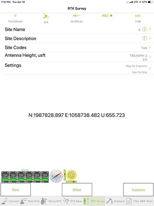
RTK Survey Operations. Robust telemetry keeps the users informed of specific satellite data and correction status.
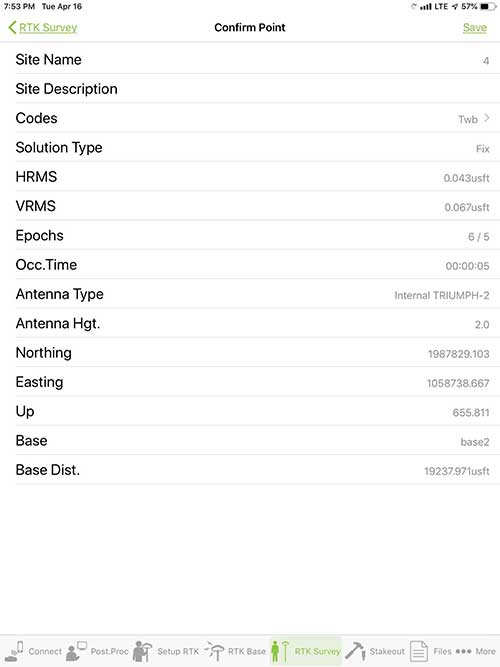
Point Confirmation. Survey point information with metadata and equipment listing. (Screenshot: Tim Burch)
Coordinate Systems. All standard coordinate systems are included with features to allow the user to customize their own systems.
Localization. Creation of a local coordinate system is a simple routine, providing strong quality checks for data integrity.
Lift and Tilt. This feature provides the user with a useful procedure to end data collection without the need to press a button. This feature significantly increases the user’s productivity.
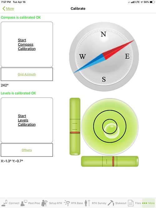
Compass and Level Calibration. With the Triumph-2 having an internal compass and level system, status of the receiver is graphically displayed to help the user keep a close watch on the accuracy of the survey point.
Survey Points and Linework. Most point naming systems and line-coding procedures are easily adapted. Total Station Point Transfer. The creation of control point files for transfer to total stations is simple and easy to use.
Stakeout. Graphical status screens provide the user with simple plotting capability of the desired stakeout point to increase efficiency and accuracy.
These apps are good at providing the surveyor with a solid tool for data collection and staking capability. They are especially good when paired with a real-time kinematic
(RTK) base station or NTRIP correction service.
But what happens when cell service is not readily available, or there are no published monument coordinates to establish site control? These apps have the surveyor covered for that situation as well.
Post-Processing (OPUS and DPOS)
Today’s surveyor works in an environment where geographic-based data is a key component to the services they render to their clients. While most of the world’s developed nations have access to cellular networks in which most GNSS receivers can communicate with an RTN providing corrective solutions, the places where this is not possible relies on other means of data correction.
In the U.S. we rely on OPUS (Online Post-Processing User System) to provide that service. But, as good as it is, it has limitations. Currently, it only utilizes GPS satellite data from the U.S. Department of Defense and is subject to sporadic government shutdowns.
Other services, from both public and private sources, are in place around the world to provide a service similar to OPUS. These include, but are not limited to:
AUSPOS. Geoscience Australia (free)
APPS. Jet Propulsion Laboratory at California Institute of Technology (free)
CSRS-PPP. Natural Resources Canada (free)
GAPS. University of New Brunswick (free)
magicGNSS. GMV (free)
Centerpoint RTX Post Processing. Trimble (free)
JAVAD Data Processing Service (DPOS). JAVAD (free, processes any JAVAD GNSS jps file)
These correction services utilize other satellite constellations (GLONASS, Galileo, BeiDou and QZSS) for their solutions and can provide additional coverage, depending on the location of the user. Because of these services, geographic-based data is at the fingertips of surveyors worldwide.
JAVAD’s DPOS system is has the ability to collect static survey data and send it to the proprietary service for establishing new coordinate values for base-station use. This process is a function of the app and can be completed in a few short steps.
Once the base station values are calculated, the surveyor can make use of this information for establishing a base station for correction broadcasting.
Do You Need a Base Station?
The establishment of RTNs has greatly enhanced surveying capability as cellular service has increased in coverage and speed. However, there are still instances and locales that do not allow for the reliable use of cell signals to provide those corrections accurately.
Various manufacturers’ tests have proven the accuracy of using an RTN subscription versus the traditional GNSS base and rover RTK setup. But cell-signal strength can be an Achilles heel, crippling those who choose not to set up a base station.
The UHF radio, even in its reduced power state from regulatory changes, is still more powerful and reliable than most cell services. 5G technology and coverage is anticipated to revolutionize cellular service, but it has yet to be realized.
Adaptation of the Industry
Other GNSS manufacturers (including NovAtel, Navcom, ComNav, Unicore, Emcore, Suzhou, TeleOrbit and Geneq) are producing receivers that can be adapted to a variety of existing data collectors and connect to iOS/Android mobile devices through various software developers.
The future of communications remains the smartphone or tablet device, with foldable units expected to be the next big thing.
As processors get more powerful, as chip memory becomes more abundant, and as more satellite constellations orbit in our sky, surveyors and their data collectors will continue to evolve. The future remains bright for technology and the surveyor has a front-row seat.
TIM BURCH is GPS World’s contributing editor for Survey. A professional land surveyor with more than 30 years of experience, he is director of surveying at SPACECO Inc. in the Chicago area. For several years he has been secretary and was recently named vice-president of the Board of Directors of the National Society of Professional Surveyors. He writes a bi-monthly column in the Survey Scene e-newsletter. Subscribe free at env-gpsworld-integration.kinsta.cloud/subscribe.
Receiver, Software Ready for Mobile
Photo: ComNav
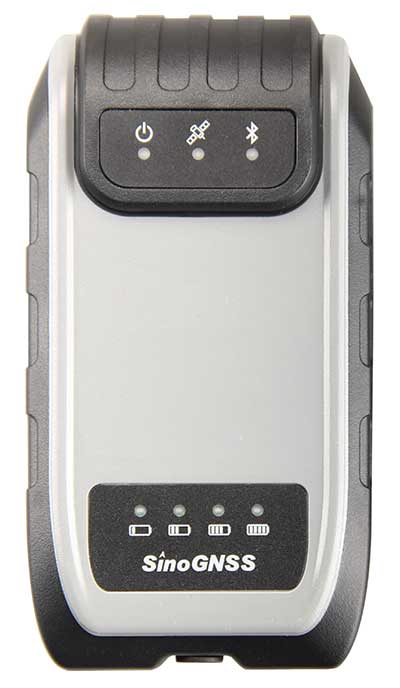
ComNav receivers offer multiple data-collection device choices via Bluetooth connection, as well as an Android app.
For instance, the G200 provides centimeter-accuracy positioning to any connected mobile devices for RTK field surveying. It is able to delivery robust survey workflows with the SinoGNSS Android-based Survey Master, so that surveyors can collect quality high-accuracy positions no matter what mobile device they are using.
The G200 is a rugged, compact, wearable GNSS receiver. Combined with the high-performance SinoGNSS OEM board tracking GPS L1/L2, BeiDou B1/B2, GLONASS L1/L2, Galileo and QZSS, the G200 enables reliable high-precision GNSS performance for land survey tasks anywhere in the world.
TerraStar Gives Assist to RTK
Photo: Leica Geosystems
NovAtel offers several levels of corrections via its TerraStar service. For surveying applications, the RTK Assist service provides correction data to bridge surveyors through any real-time kinematic (RTK) correction outages. TerraStar services work on NovAtel’s OEM6 and OEM7 receivers..
RTK Assist, available on OEM6/OEM7 receivers, provides 20 minutes of RTK assistance, enabling surveyors to maintain centimeter-level accuracy. A higher service level, RTK Assist Pro, is available on OEM7 receivers. It provides unlimited RTK assistance with stand-alone centimeter-level positioning when RTK is not available.
Trimble Offers Web-Based Post-Processing
Photo: Trimble
Trimble’s CenterPoint RTX Post-Processing Service is a free, web-based solution that provides rigorous processing of GNSS data for users around the globe.
Powered by advanced algorithms for processing static observations, CenterPoint RTX Post-Processing supports data including GPS, GLONASS, Galileo, BeiDou and QZSS. With the service, users can upload GNSS data using Trimble formats or industry-standard RINEX 2 and RINEX 3. The service supports all dual-frequency GNSS receivers and more than 400 different antennas.
The post-processing service computes single-station static observation sessions ranging in length from 10 minutes up to 24 hours, with longer observation sessions recommended to produce the highest accuracy. Using data from the global RTX tracking network, the CenterPoint RTX Post-Processing service computes the position of the observed point with centimeter accuracy.
Results are delivered via email in ITRF coordinates at the current epoch and can be transformed to a fixed epoch by use of a standard tectonic-plate model.
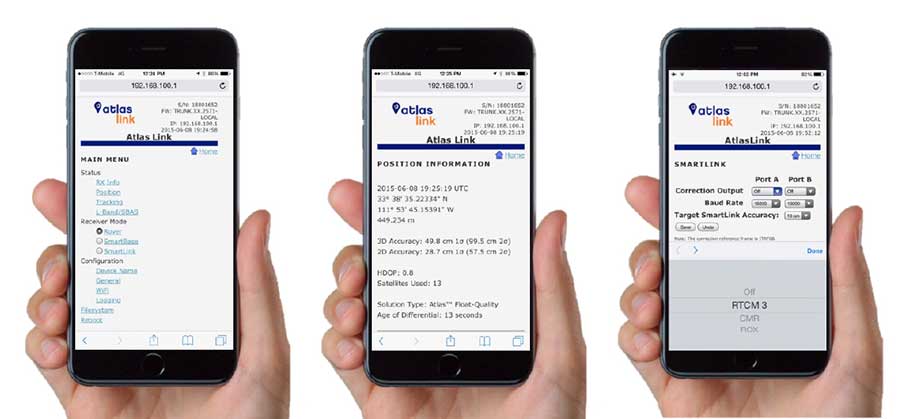
Atlas Corrections Ready for BYOD
The Atlas GNSS global correction service, offered by Hemisphere GNSS, provides correction data for GPS, GLONASS, BeiDou and Galileo constellations. Its global L-band corrections allow for accuracies ranging from sub-meter to sub-decimeter levels. The network has more than 200 reference stations worldwide and covers virtually the entire globe.
Examples of how the AtlasLink webUI looks on a smartphone. (Image: Hemisphere GNSS)
The Atlas platform was conceived to enable as many people as possible to have access to the correction service technology, either as an end-user or as part of their business. Several features are designed to enable customers who use non-Hemisphere positioning systems to have access to Atlas.
For instance, Hemisphere’s SmartLink technology allows an AtlasLink GNSS smart antenna to be used as an Atlas signal extension for any GNSS system compliant with open communication standards.
Hemisphere’s GNSS smart antennas including AtlasLink, A326, C321+ and S321+ offer a user-friendly web user interface (WebUI) that can be used to configure, monitor and manage the receiver from virtually any modern computing device, including computers, phones and tablets.
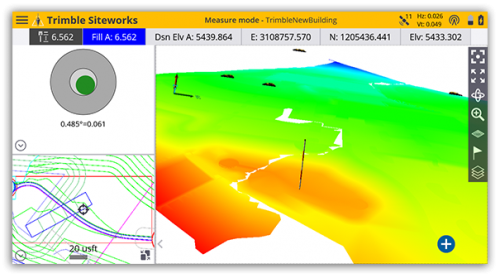
Trimble has introduced Siteworks Software version 1.1, featuring full GNSS tilt compensation functionality in standing, walking and vehicle modes, and support for the Android operating system.
Construction surveyors can now capture accurate points without leveling the pole, making surveying in areas such as building corners accurate, fast and easy.
In addition, Siteworks version 1.1 now supports the Android operating system, giving contractors the flexibility to choose the field device that best fits their needs and budget.
The announcement was made at the bauma 2019 trade fair for construction machinery, building material machines, mining machines, construction vehicles and construction equipment. Bauma 2019 takes place this week in Munich.
“GNSS tilt compensation makes site positioning more accessible and easier to learn for beginners, while experienced surveyors can see significant time savings,” said Scott Crozier, general manager for Trimble’s Civil Engineering and Construction Division. “And now Trimble Siteworks gives contractors more choices. They can run Siteworks on either Windows 10 or Android.”
GNSS Tilt Compensation
Using Trimble Siteworks and a Trimble SPS986 GNSS smart antenna, construction surveyors can take measurements faster and perform more efficient stakeouts.
The solution was designed to shield magnetic interference, and it can be used effectively anywhere on a construction site.
There are three modes available that support tilt compensation, so contractors can record accurate points while standing, walking or driving the site in a vehicle. Tilt compensation in vehicle mode is designed to capture higher accuracy measurements on steeper slopes from a moving vehicle, and more accurate volume measurements to save time and money on material planning.
Easy to use for beginners and users without traditional training, tilt compensation allows points to be recorded more safely, eliminating the need to stand in the road to measure a traffic lane, for example. Surveyors can also measure points that they couldn’t before, such as building corners, edges of trenches and utility flowlines.
Trimble Siteworks for Android
Trimble Siteworks can now support a contractor’s bring-your-own-device (BYOD) strategy with Android compatibility. This is helpful for price-conscious users such as owner operators and utility contractors, or users who need a less rugged solution for lighter use.
The option gives contractors the freedom to choose the device that works best for them, increasing the flexibility and affordability of the Trimble Siteworks Positioning System.
Availability
Trimble Siteworks Software version 1.1 is expected to be available through the worldwide SITECH distribution channel in the second quarter of 2019.
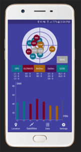
Global GNSS, a subsidiary of Polosoft Technologies, has launched a new mobile application named GNSS Surveyor, which is designed for the geospatial industry.
The application GNSS Surveyor provides location information and quality position data in real-time with sub-meter to centimeter accuracy. It needs to be connected to any external GNSS receiver via Bluetooth.
Features of the application include:
A one-touch configured command to communicate directly with the GNSS Bluetooth device.
Location information and quality of the position data in real-time with centimeter accuracy.
GPS data such as position, height, satellites and velocity.
Constellation information for GPS, GLONASS, Galileo, BeiDou, QZSS and SBAS satellites in the orbit.
Direct IP feature for RTK corrections data.
DMS to DD conversion or vice versa.
Real-time kinematic (RTK) correction data can be forwarded to a high-accuracy external device. The internal NTRIP client loads the RTCM data from the internet.
With GNSS Surveyor, location information is collected as latitude and longitude, altitude, speed or pace, bearing and UTC time.
GNSS precision includes global coverage, centimeter-level accuracy, fast time to first fix, multi-constellation and multi-band, and highest security, the company said.
Navigation uses include ground robotics navigation, lane-level navigation, heavy machine navigation, industrial navigation and tracking and commercial UAV.
Reflecting the dramatic changes and advances that have taken place in the applications of positioning technology over the last decade, the plenary session of the 37th meeting of the Institute of Navigation’s Satellite Division did not discuss satellites at all. Instead, two keynote speakers elaborated upon the application of positioning to emergency response services and to airborne mapping with lidar technology.
Emergency Location Service (ELS) in Android
Steve Malkos, technical program manager at Google, told the audience of approximately 800 that the new emergency location service “is our passion project at Google. Just last week we announced the expansion of ELS into the U.S. It’s here and it’s ready today. But the work isn’t done yet because of various challenges.” Google’s goal is 1-meter location accuracy for all 911 calls placed on cell phones. The algorithms discussed at ION this week, Malkos said, are part of what is driving Fused Location Provider (FLP)
toward this future.
In FLP, locations are computed directly on the handset as opposed to the older method, which computes on the carrier’s cell network. Google’s indoor solution consists of wi-fi augmented by network information.
Recently released statistics show emergency call usage has flipped from what it was only a decade ago. Now, only 20 percent of emergency calls are placed on landlines. Eighty percent are placed on wireless devices.
Malkos replayed audio from a call made recently, prior to activation of ELS, that generated a location on Miami’s emergency services of 500 meters away from the basement ballroom of the conference hotel.
Domino’s Pizza, Uber ride service and Facebook all now use the hybrid derived location from cell phones, while emergency services typically use the location computed on the carriers’ network, and relying on cell-tower positioning. Cells range from 100s of meters to kilometers in size.
ELS has been live in the U.K. since June 2017. Since its activation, British Telecom’s mean radius accuracy on emergency calls went from 2 kilometers to 43 meters 85 percent of timeION20.
Malkos discussed the challenges of privacy, altitude (Z-axis) and the related difficulties in the urban high-rise landscape of floor determination and infering floor labels.
Overall, he said, statistics show that each 1 minute sooner of arrival of emergency services translates to 10,000 saved lives.
A Lidar History
Paul LaRocque, vice president of special projects at Teledyne Optech gave an overview of light detection and ranging (lidar) development through the lens of a one-company centric history, that of Teledyne.
Lidar got started in 1969, within a decade of the invention of the first laser. It began with early work in marine mapping and bathymetry from onboard ships. Airborne lidars developed in the late 1970s, looking at icefields in the Arctic, and was done at first with no absolute positioning to aid in analyzing the results..
Early on, developers discovered that airborne lidar can get to the bare earth, penetrating under forest canopy. This eventually led to the recent dramatic discoveries of long lost Mayan cities, covered by jungle.
In the early 1990s, GPS and inertial technologies converged, with some miniaturization, to enable building of integrated technology systems that added absolute positioning to the lidar toolbox.
LaRocque provided a quick look at the National Geographic story, based on data from a three-wavelength Teledyne Optech Titan, one of several current machines that are generating data at millions of shots per second. Increasingly, it’s the software processing that brings out the accuracy, for example, centimeter accuracy surveyed from a kilometer up in the air.
Challenges enumberated:
the speed of light is not fast enough.
the Earth is not flat enough.
Teledyne developed PulseTRAK technology to cope with the “blind zones” generated by these two challenges, so as to not lose data in any gaps.
The new frontier is spaceborne lidars. Teledyne is involved in a project tenerating lidar data from the surface of Mars on a Canadian space agency mission. This led previously to the discovery of snow in the atmosphere of Mars. The OSIRIES-Rex mission now on its years-long voyage to a very-far off asteroid represents the furthest adventure of lidar in space. The project will collect data on the asteroid’s surface and beam it back to Earth, as well as eventually returning some core samples.
Steve Malkos of Google, and a GPS World contributor, will address the ION GNSS+ plenary session at the technical meeting and showcase, to be held Sept. 24-28 in Miami.
Malkos will address “Emergency Location Service in Android.” When emergency services get a call, they need to know the caller’s location to send help and save lives. More than 80 percent of calls to emergency services come from mobile phones, but locating these mobile callers can be a major issue.
Current emergency solutions rely on cell tower location (which can have a radius of several kilometers) and, in some countries (like the U.S. and Japan), on A-GNSS. But A-GNSS can fail with weak signal reception, in urban canyons and indoors.
Malkos will discuss how Emergency Location Service in Android is delivering more accurate location (computed from fusion of Wi-Fi, cell, GPS and sensors) to emergency services when an emergency call is detected.
Paul LaRocque
Also speaking is Paul E. LaRocque, Teledyne Optech‘s vice president of Special Projects. In his presentation, “A Lidar History: From Ship to Air to Space,” LaRocque will give a historical review of the airborne laser mapping systems that Teledyne Optech has designed and built over the years.
Optech has been active in laser radar systems beginning with marine lidars and later moving to airborne and spaceborne systems. Navigation has been an important subsystem in these developments, and its role will be described as part of this story.
LaRocque has been involved in the development of Optech’s lidar systems since the late 1980s. Dr. LaRocque was instrumental in the design of Optech’s airborne lidar bathymeters, airborne lidar terrain mappers (ALTM), and waveform digitizers, as well as other special lidars.
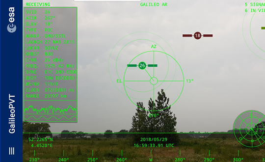
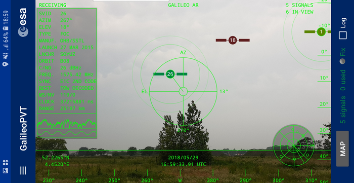
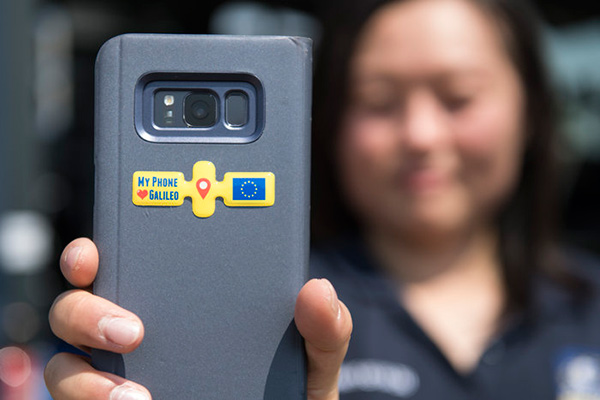
The European Space Agency (ESA) has released an augmented reality view of Galileo satellites in the sky close to its technical centre in the Netherlands.
The image comes from a Galileo-focused satnav app for Android smartphones, developed by ESA engineers. ESA ran an internal competition for its trainees to develop an app capable of making positioning fixes using only Galileo satellites.
“As part of our support for the competition, we developed our own app on a voluntary basis to serve as a benchmark,” said Paolo Crosta of ESA’s Radio Navigation Systems and Technology section. “We included this augmented reality view, so users can ‘see’ the satellites their smartphone is using as they hold it up to the sky.”
Galileo satellites viewed in smartphone app. (Photos: ESA)
The positioning calculations and assistance data functions for the app were developed by Paolo, with telecom engineer Tim Watterton contributing the main structure of the app, together with how it looks and its user interface.
“The satellites are overlaid in real time on the camera view in their predicted positions in the sky, based on ‘ephemeris’ information, assistance data that describes the current satellite orbits with high precision,” Watterton said. “When a signal is being received, the satellite is shown in green, overlaying the predicted position. The satellite shown in red is one of the two placed in elongated orbits, but these satellites are expected to be used soon in the operational constellation. Satellites colored orange are transmitting, but the signal is not detected, which may be due to obstruction by terrain or buildings.”
Panning the phone around to position the crosshair over a green-colored satellite adds additional information, such as its signal status, pseudorange (the uncorrected distance the signal has traveled to reach the receiver) plus the satellite’s manufacturer and launch date, among other items.
The reference app is now being tested with the hope of making it publicly available on the Google Play Store. Following the competition, the trainees are also testing their own apps with the goal of releasing them.
The Trimble Catalyst software-defined GNSS receiver for Android phones and tablets has been updated to support GLONASS. The update demonstrates the advantages of software GNSS for delivering new functionality faster and easier, according to Trimble.
Access to the GLONASS constellation increases the number of GNSS satellites visible when working in the field. As a result, it improves the ability to maintain lock on enough satellites to keep working when sky visibility is limited or obstructed, such as under tree canopy and in urban high-rise environments, Trimble said. Users also spend less time waiting for the receiver to achieve an accurate position, and convergence time is faster and more reliable.
Trimble Catalyst provides users with positioning-as-a-service to collect highly accurate location data with Trimble or third-party apps on Android smartphones and tablets. When combined with a small, lightweight, plug-and-play DA1 digital antenna and Catalyst subscription, the receiver provides on-demand GNSS positioning capabilities, and transforms consumer devices into centimeter-accurate mobile data collection systems.
“Adding GLONASS to Trimble Catalyst provides productivity improvements and more robust positioning for Catalyst users,” said Gareth Gibson, Catalyst business development manager at Trimble. “In addition, since the service is provided via an Android app, performance updates are available through the Google Play store. As a user, receiving updates is easy and automatic.”
Testing of the three Galileo apps took place in May. (Photo: ESA)
ESA challenged its young graduate and national trainees to develop a smartphone app to perform satnav fixes using only Galileo satellites.
Three teams developed apps in their spare time, presenting their results to a jury of experts from ESA, the European Global Navigation Satellite Systems Agency (GSA) and Google.
“I’m very impressed,” said Javier Benedicto, ESA’s Galileo programme manager. “With little detailed knowledge of satellite navigation, these teams have developed something that didn’t exist just a few months ago. Working on Galileo we love to see that the systems we’re putting together can reach widespread application and inspire new uses.”
The winning Galfins Team put together the GNSS Compare app that promises to turn a smartphone into a “research lab in your pocket” to test Galileo performance in isolation or in combination with other systems. Their prize is to attend an ESA and European Commission-sponsored GNSS Summer School in Austria.
The final presentation and results of ESA’s internal Galileo smartphone app competition took place in the Erasmus centre of ESA’s Erasmus technical centre on May 31. (Photo: ESA)
“Only one of our four-strong team started the challenge with any knowledge about satellite navigation,” said Mateusz Kraiński of the Galfins team. “The rest of us come from different areas — for example, I’m working on the European Robotic Arm project, due to launch at the end of next year. We have learnt a lot and the radio navigation experts at ESTEC were a great source of support.”
“We see a need on the market for such an application, so we will definitely continue with the development. The application will be made available for download when ready, and the project will be released as open source soon after.”
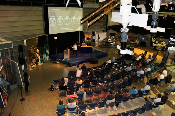
The other two teams were also commended for their work; Chocolateam developed a richly-designed game-based app, giving the user the feeling of observing the Galileo satellites from a spacecraft, while Team 5G distinguished themselves by writing all their own navigation algorithms from scratch rather than relying on open source software.
The challenge was to design an Android smartphone app that allows users to compute and visualize their position based solely on Galileo measurements, as well as the possibility of selecting a combination of satnav constellations to assess their performance.
Testing the three apps entered in the Galileo smartphone app competition in the grounds of ESTEC, working in pedestrian mode. (Photo: ESA)
The receiver chipsets inside smartphones make use of Galileo signals in combination with several other satnav constellations — the U.S. GPS, Russian GLONASS and Chinese BeiDou. These chipsets function like “black boxes,” making the resulting positioning fix accessible to users, but not giving any option for the user to select which constellation to employ.
Current phone applications only display general satnav status information, such as which satellites are contributing to the positioning fix, their visibility parameters and overall power levels. This is not sufficient to single out Galileo’s contribution to the phone’s overall positioning performance.
However, in newer Android smartphones it has become possible to access the raw signal measurements used to compute position, opening the door to the development of applications where the user can indeed select which satellites to use.
The teams received one Galileo-enabled smartphone each for developing and testing the app.
ESA’s Director of Technology, Engineering and Quality supported the teams by supplying dedicated software modules to simplify computations of the phone position. During the competition, a technical advisory team also developed an internal app as a benchmark.
The app, named Galileo PVT and developed by ESTEC engineers Paolo Crosta and Tim Watterton, includes an augmented reality system allowing users to “see” the Galileo satellites from which they were receiving signals in the local sky.
“This was a very useful exercise because it helps us understand the needs of satnav app developers in Android,” said the lead advisor, Paolo Crosta. “Then, once the apps were complete, we tested them together, here on the grounds of ESTEC, working in stationary, pedestrian and vehicular modes.”
“Congratulations to all the teams here today,” said Frank Van Diggelen from Google, who had just come from a satnav raw measurements workshop hosted by GSA. “It’s been great to be here and see all the activity around raw signal measurements. Our aim has always been to raise standards by making these measurements available, to let developers see what’s happening inside. And the work you’re doing here is feeding back to chip and smartphone manufacturers, to help change and improve them for the future.”