Septentrio’s new web shop offers direct access to mosaic multi-frequency GNSS receiver module. Customers can purchase the mosaic development kit quickly and easily to evaluate this unique module.
Septentrio has opened an online store shop.septentrio.com, selling high-performance GPS/GNSS module receivers. The web shop is accessible via the Septentrio website, offering customers multi-constellation multi-frequency GNSS technology, which provides reliable centimeter level positions suitable for demanding applications.
The first product available for sale online is mosaic, Septentrio’s most compact GNSS receiver module. This light-weight, low-power receiver brings robust high-accuracy positioning to the mass market. With its security-centered anti-jamming and anti-spoofing technology, mosaic provides positioning to numerous demanding applications such as automotive ADAS, logistics automation, and robotics.
“We see a growing demand for reliable high-accuracy positioning across various industries. As GNSS receivers move towards becoming a commodity, we are providing our customers with easier and faster access to GNSS technology,” said Francois Freulon, senior product manager, Septentrio. “We are happy to offer the mosaic development kit as the first product in the shop, which makes it easy for people to purchase and evaluate the mosaic module and discover its capabilities for delivering robust, highly-accurate positions. “
True multi-frequency multi-constellation technology of mosaic ensures access to every possible signal from all available GNSS constellations including the U.S. GPS, European Galileo, Russian GLONASS, Chinese BeiDou and Japanese QZSS satellites. Septentrio’s advanced field-proven algorithms exploit this signal diversity to deliver maximum positioning availability even in the most difficult environments such as under foliage or in urban areas.
GNSS signals can become jammed by nearby electronics or illegal jammers that emit radio signals interfering with GNSS. Mosaic uses jamming-resistant signal processing making it robust against interference. Its design focuses on continuous, reliable high-accuracy positioning making mosaic suitable for demanding applications such as ADAS, UAVs and industrial automation.
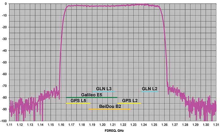
J-Shield is a robust filter on Javad GNSS antennas that blocks out-of-band interference (Figure 1). In particular, J-Shield blocks signals that are near the GNSS bands, including the proposed Ligado Networks (formerly LightSquared) broadband signals, explained Javad Ashjaee, founder and CEO of Javad GNSS.
FIGURE 1. Protection characteristics: The J-Shield filters have a sharp 10-dB/KHz skirt, which provides up to 100-dB of protection. (Image: JAVAD GNSS)
The anti-jam digital filters protect against in-band interference such as the harmonics of nearby TV and radio stations, or against illegitimate in-band transmissions. The anti-jam filters can be combined in pairs for complex signal processing and can simultaneously suppress several interference signals.
“The filters make the near band spectrums available for other uses,” Ashjaee said. “They protect GNSS bands now and in the future.”
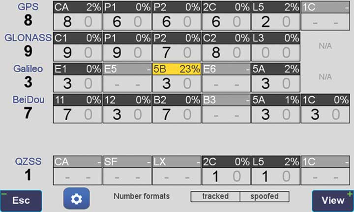
In-Band Noise Measurement. The receiver measures the level of interference as a percentage of noise above the normal condition. Figure 2 shows the condition in a clean environment, where eight GPS satellites were visible, according to the almanac. In all, eight C/A, six P1, six P2, six L2C and two L5 GPS signals were tracked. The noise level was 2% on C/A and L5 and 0% on P1, P2, and L2C.
FIGURE 2. Clean environment. (Image: JAVAD GNSS)
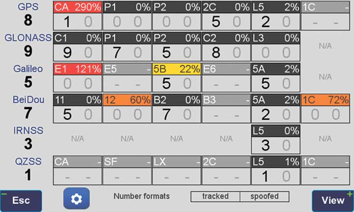
Figure 3 shows 290% noise in the GPS C/A signal and 121% noise in Galileo E1. Only one of the eight GPS C/A code and none of five Galileo E1 signals could be tracked because of the high level of interference.
FIGURE 3. High interference levels. (Image: JAVAD GNSS)
Spectrum Analyzer
Filters in the GNSS antenna provide one way to protect GNSS signals from interference. Another is the receiver chip itself. For instance, the Javad GNSS Triumph chip includes an integrated spectrum analyzer — a more efficient solution than using a commercial spectrum analyzer to continuously monitor and evaluate the environment, Ashjaee explained.
The spectrum analyzer monitors the spectrum inside the chip. It has an effective bandwidth of 1 KHz, and can be programmed to automatically record the spectrum (and other information) periodically or according to pre-set conditions. Each spectrum shows the power and shape of any interfering signals and jammers.
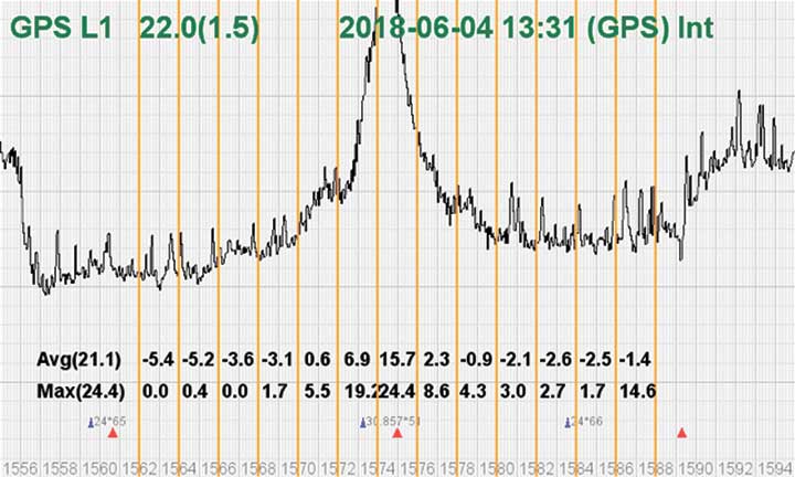
Figure 4 shows the shape of the GPS L1 band spectrum when the band is jammed, as indicated by the huge peak in the center where the C/A code is. The number on the bottom left is the height of the peak. The height of the spectrum is 21.1 dB; compared to a calm spectrum of 11.2 dB, this spectrum indicates a jamming impact of about 10 dB.
FIGURE 4. The L1 band is jammed, as shown by the peak. (Image: JAVAD GNSS)
Automatic Gain Control. In addition to monitoring the spectrum, the Triumph chip also keeps a record of automatic gain control (AGC) — another indicator of unwanted external signals. The AGC monitors the environment and adjusts the gain to keep the voltage at a certain level. The change in AGC is an indicator of interference.
Spoofers
“Spoofers are quite different from jammers,” Ashjaee said. “They don’t disturb the environment and the spectrum shape. They broadcast a GNSS-like signal to fool the GNSS receivers to calculate wrong positions. We detect spoofers by digital signal processing.”
With 864 channels and about 130,000 fast-acquisition channels in the Triumph 2 chip, it has the resources to assign more than one channel to each satellite to find all of the signals transmitted with the same GNSS PRN code — including spoofed signals.
“If we detect more than one reasonable and consistent correlation peak for any PRN code, we know that we are being spoofed and can identify the spoofer signals,” Ashjaee said. The chip isolates and ignores the wrong peak.
“Usually more than 100 signals are available at any given time. We need only four good signals to compute position,” Ashjaee said. “We reject infected signals, and then among all the available GPS, GLONASS, Galileo, BeiDou, IRNSS and QZSS signals, we use the healthy ones. It is extremely unlikely that we can be spoofed without our knowledge. We can immediately recognize spoofing and take corrective actions. In the rare case that all signals are affected, we inform the user and guide them to use a compass and altimeter to get out of the jammed area.”
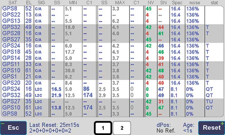
Figure 5 is a screenshot from the company’s Triumph-LS survey receiver, showing the details of each signal tracked. The first six lines in this screenshot show the spoofed signals that were detected as soon as they appeared (number “1” in the C1 column). Percentages show the amount of interference above the normal level.
In the last column, T indicates the signal was tracked by the main channels, Q by the fast-acquisition channels, and U indicates the signal was used in position calculations.
Figure 5. Signal Details: The Triumph-LS receiver provides users with a wealth of information on each signal received, including spoofed signals.
Indicators for Healthy Signals
In addition to the spectrum shape and AGC, these other indicators show the health of GNSS signals:
Number of signals tracked.
Divergence of SNR from its expected value.
Level of additional power and its RMS.
Divergence of AGC from its normal value and its RMS.
Extra noise.
Number of signals spoofed.
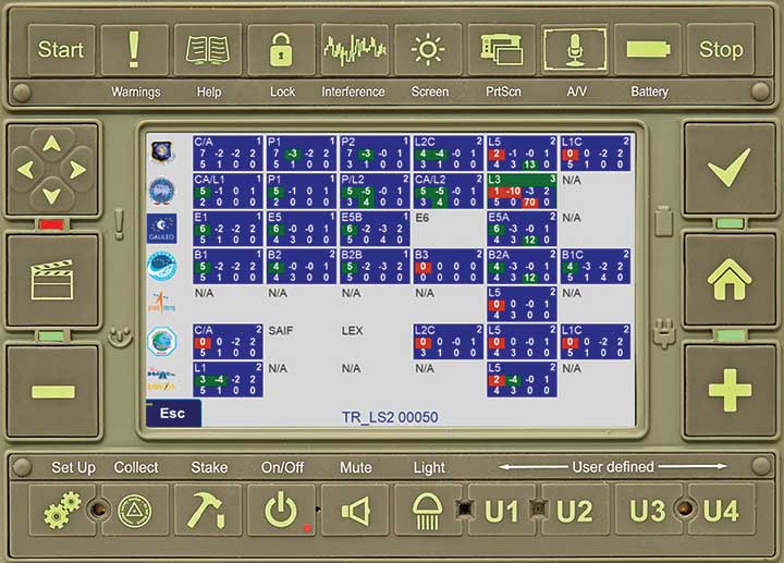
As an aid to users, the company’s Triumph-LS receiver can display the status of all GNSS signals received. Figure 6 shows this compact view, with normalized values of the above indicators (0 means good and 9 means poor).
Figure 6. Signal Status. Information on all GNSS signals received as shown by the Triumph-LS. (Image: JAVAD GNSS)
Users of the Triumph-LS can click on any of the signal buttons to see the actual and normalized values of the indicators for that signal. Action buttons provide quick access to View Satellites, View Spoofing, View Spectrum and Take Spectrum. Jamming and spoofing protection is an option on all Javad GNSS products and OEM boards.
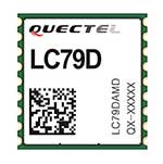
Quectel Wireless Solutions has launched a compact dual-band GNSS module, the LC79D, that supports the L1 and L5 bands from navigation satellites to improve positioning accuracy.
Featuring concurrent multi-constellation GNSS receivers on dual GNSS bands, LC79D uses L1 and L5 bands for GPS, Galileo and QZSS satellites, L1 band for GLONASS and BeiDou satellites, and L5 band for IRNSS satellites.
Compared to GNSS modules that use the L1 band only, LC79D can generally increase the number of visible satellites, significantly improve positioning drifting when driving in rough urban canyons and enhance positioning accuracy.
Embedded with a low-noise amplifier (LNA) and multi-tone active interference, the module provides higher sensitivity and reliable anti-jamming capability, ensuring exceptional acquisition and tracking performance even in weak signal areas. Multiple communication interfaces including UART and SPI simplify customer designs and accelerate time-to-market for customers’ products at reduced costs.
With dimensions of 10.1 × 9.7 ×2.4 millimeters, the tiny LC79D meets the requirements of size-sensitive applications. Compact design, low power consumption and high performance make it suitable for vehicle, people and asset tracking as well as sharing economy applications.
“The launch of LC79D shows Quectel’s global leading position to provide positioning modules for applications requiring higher accuracy and reliability, especially in rough environments with weak signals,” said Wang Min, automotive and GNSS product director at Quectel. “LC79D gives customers high-level integration and flexibility to realize precise positioning in real time.”
The LC79D module was showcased at MWC Shanghai 2019 during June 26-28.
Dean Kemp, defense segment manager for NovAtel, has joined the speakers’ panel for the June 27 complimentary webinar, Advanced Simulation Test Systems for Controlled Reception Pattern Antennas. He will present unique content alongside Lisa Perdue, simulation product manager for Orolia, and Stéphane Hamel, director of testing at Orolia.
Kemp has over 20 years of academic, industrial and business experience in engineering products and services. He spent a significant part of his career involved in antenna design and development, including controlled reception pattern antennas (CRPAs) for GPS anti-jam systems. As Defense Segment Manager, he is committed to precise, assured positioning and timing to address the needs of Navigation Warfare (NAVWAR) professionals and is dedicated to delivering high-quality products into the defense markets.
He holds a Ph.D. in antennas, radiowave propagation and computational electromagnetics from the University of Liverpool and an MBA from the University of Warwick. Prior to joining NovAtel, he worked at API Technologies, Cobham and Cobham Technical Services. His key technical skills include antenna/RF/microwave engineering, software development (Matlab, Fortran, VBA, Python), data analysis and processing, and test and measurement.
CRPAs are advanced, multi-element antenna solutions designed to protect a GNSS/GPS receiver from jamming sources. When combined with antenna electronics, they form an anti-jam antenna system (AJAS). These systems utilize several available technologies and vary in the number of elements.
This webinar will cover the basics of AJAS and CRPA, and the methods used to test them. Details on simulation system configurations, calibration techniques, and use case examples will also be presented. The webinar is sponsored by Orolia, a global provider of GPS/GNSS and resilient PNT solutions to support military and commercial applications.
NovAtel has added the GAJT-410ML to its GPS Anti-Jam Technology (GAJT) portfolio. Designed specifically for rapid integration into space-constrained military land applications, the easy-to-use system protects GPS-based navigation and precise timing receivers, including M-code, from both intentional and accidental interference, the company said.
The GAJT-410ML is the next evolution of NovAtel’s battle-proven anti-jam technology. It maintains the high levels of interference rejection performance as in the larger GAJT-710ML system, but in a lower size, weight and power (SWaP) design.
Photo: NovAtel
Working alongside the GAJT-410ML, the Power Injector Data Converter (PIDCTM) provides access to the jammer status and direction-finding (DF) information. It also provides clean power and data over the same cable that delivers the protected GPS signal back to the receiver, which reduces the need for costly platform modifications. The PIDC can be supplied in either an enclosure or board and is available to license for installation into third-party equipment.
NovAtel Defence Segment Manager Dean Kemp noted, “Building on the success of our existing anti-jam portfolio, the GAJT-410ML is the first system to address the needs of smaller land-based platforms and add situational awareness capability to already high levels of mitigation performance.”
“This product offers more choices for system integrators and end users to protect against GPS denied or constrained situations and delivers on our commitment to provide assured positioning anywhere,” Kemp added.
Learn more about the GAJT-410ML anti-jam antenna or talk with NovAtel’s team of specialists at these upcoming trade shows:
The Special Operations Forces Industry Conference (SOFIC) – May 20 – 23, 2019, Tampa, FL USA
CANSEC – May 29 – 30, 2019, Ottawa, ON Canada
Joint Navigation Conference (JNC) – July 8 – 11, 2019, Long Beach, CA USA
International Defence Industry Exhibition MSPO (Canadian Pavilion) – September 3 – 6, 2019, Kielce, Poland
Defence & Security Equipment International (DSEI) – September 10 – 13, 2019, London, UK
Centum Solutions of Madrid, Spain, introduced its NO JAM ZONE interference detector ION GNSS+ in Miami.
NO JAM ZONE is Centum’s solution for GPS interferences detection and location.
Centum will have a booth in the ION GNSS+ exhibit hall to showcase NO JAM ZONE, as well as and a GNSS simulator to show the process of detection and location of different sources of interference.
Critical infrastructures need to ensure the proper functioning of their radio frequency systems. A good example of this is airports. NO JAM ZONE is a GNSS spectrum monitoring system, capable of detecting interferences that affect the proper functioning of these systems.
NO JAM ZONE works with the most-used GNSS frequencies. Because of its distributed network of beacons, the system is able to give, in real time, the position of a source of interference.
NO JAM ZONE can detect the following types of interference:
Service interruption (jamming)
Spoofing interference
Induced electromagnetic emissions whose power exceeds a certain harmful threshold
Centum also offers the NO FLY ZRONE drone and remotely piloted aircraft system (RPAS) detection and protection system. The active defense system is capable of detecting threats and creating a shield of electronic countermeasures preventing the intrusion of drones in protected areas and diverting them to safe catch areas.
NO FLY ZRONE is effective against the vast majority of drones and RPAS, whether radio-controlled by an operator or by autonomous guidance through GPS. It detects drones and discriminates against those that constitute potential threats.
Once the threat has been classified, NO FLY ZRONE neutralizes the drone control system by taking control of it and driving it to a safe area for its descent and capture; it can also geolocate the operator of the drone.
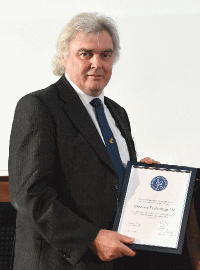
Charles Curry, founder of Chronos Technology, with the RIN award. (Photo: Chronos)
Chronos Technology has been recognized by the Royal Institute of Navigation (RIN) with its 2018 Duke of Edinburgh’s Navigation Award for Outstanding Technical Achievement in “recognition of technical excellence and authority in satellite navigation and timing vulnerabilities and mitigations.”
Charles Curry, founder and managing director of Chronos Technology, accepted the award at the RIN Annual General Meeting held June 10 in London.
Chronos has worked with the RIN and others since 2008 to raise awareness of GNSS vulnerabilities, and in collaboration with the University of Bath has developed a family of GNSS interference detection products.
Chronos first started researching this phenomenon with the University of Bath in the Innovate U.K. project GAARDIAN in 2008, closely followed by the SENTINEL and AJR projects. The projects have focused on detecting and locating commercial off-the-shelf jammers mostly sourced from Chinese websites.
The first success was seizing the so called “Girvan Jammer” in 2011, when a jammer was recovered from a commercial van driver through collaboration with the serious and organized crime group of the local police.
This exercise took about two weeks from initial detection to recovery of the jammer and should be compared to the six months it took U.S. enforcement agencies to identify the so called “Newark Jammer.”
SENTINEL sensors were originally rolled out in 2010 continue to provide real evidence of jamming at various locations around the U.K. The project assists police work by collating jamming events by day and time of day using a cloud-based portal.
The GPS interference detection portfolio includes low-cost, handheld GNSS interference detectors with features such as data logging and direction finding capabilities to precisely pinpoint a jammer.
The latest product to emerge is known as “JammerCam,” and is the first GPS jamming detector in the world to be able to take photographs of a moving vehicle, which is carrying a GPS jammer. This is now in trials with various local police forces and is photographing vehicles with jammers on a daily basis, providing real-time actionable intelligence to the law enforcement officers’ smartphones identifying vehicle type, color and number plate.
Early trials with this research are leading to the seizing of at least one jammer per week by U.K. law enforcement agencies.
Chronos has demonstrated the ability to work with universities and potential users to develop new, affordable products to meet a genuine need. Customers include U.K. and international law enforcement agencies and military users.
“This is a very prestigious award, as a look at the previous winners will attest,” said John Pottle, director of the Royal Institute of Navigation. “Chronos is very well respected and has continued to innovate, achieving global influence from their U.K. base. Many congratulations to all at Chronos for this well-deserved recognition.”
Curry was awarded Fellowship of the Royal Institute of Navigation in 2016 in recognition of his significant and continuing contribution to the practical aspects of time measurement and dissemination, including research into GNSS vulnerabilities and the use of eLoran for precise time.
“Chronos is honored to be the recipient of the RIN’s 2018 Duke of Edinburgh’s Navigation Award for Outstanding Technical Achievement,” Curry said. “We could not have done this without our close association with the University of Bath, in particular Dr. Robert Watson and Professor Cathryn Mitchell and their colleagues in the Electrical & Electronic Faculty.
Over the years, this association has enabled Chronos to undertake research and bring to the market GPS jamming detection products which have been thoroughly field tested at locations such as Sennybridge in the Brecon Beacons, and other international jamming trials in Norway and the U.S.
“In particular, Chronos was the only British company to be invited to JamX17 in Idaho Falls, U.S., by the U.S. Department of Homeland Security to showcase the detectors’ technology,” Curry said.
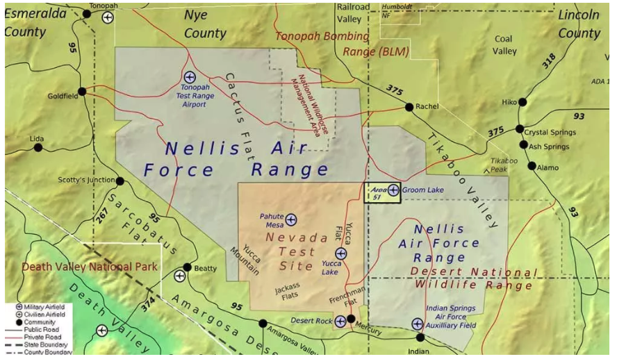
The U.S. Air Force is intermittently jamming its own GPS signals over southern Nevada and Utah this week and next as part of a massive air-to-air combat training exercise, Red Flag 18-1, based out of Nellis Air Force Base in Nevada. The jamming aims to challenge aircrews and their weaponry under realistic fighting conditions. The Air Force has warned that navigation systems including those found in commercial flights may be disrupted or jammed completely across the southwest U.S. during that time, ending February 16. So far no major commercial airline disruptions, flight delays or re-routings have been reported.
The U.S. military, heavily and perhaps overly reliant on GPS, is developing a range of position, navigation, and timing (PNT) technologies being to help overcome the loss of GPS during combat, an increasingly likely scenario now and in years to come. Some have speculated that this year’s exercise specifically has in mind a possible conflict on the Korean Penisula. GPS jamming has regularly emanated from North Korea over the past several years.
“We’re trying a few new and different things with Red Flag 18-1,” said Col Michael Mathes, 414th Combat Training Squadron commander. “This primarily is a strike package focused training venue that we integrate at a command and control level in support of joint task force operations. It’s a lot of words to say that we integrate every capability we can into strike operations that are flown out of Nellis Air Force Base.”
The exercise, which the Air Force conducts annually, typically involves a variety of attack, fighter and bomber aircraft with added participation from the U.S. Navy, U.S. Army, Marine Corps, Royal Australian Air Force and Royal Air Force. This year’s Red Flag is the largest in the exercise’s 42 year history.
Nellis Air Force Base in southern Nevada. (Image: USAF)
Affected Areas. “Arrivals and departures from airports within the Las Vegas area may be issued non-Rnav re-routes with the possibility of increased traffic disruption near LAS requiring airborne re-routes to the south and east of the affected area,” stated an Air Force bulletin. “Aircraft operating in Los Angeles (ZLA) center airspace may experience navigational disruption, including suspension of Descend-via and Climb-via procedures. Non-Rnav SIDs and STARs may be issued within ZLA airspace in the event of increased navigational disruption. Crews should expect the possibility of airborne mile-in-trail and departure mile-in-trail traffic management initiatives.”
Alternate Capabilities. Many Air Force planes have onboard inertial navigation systems, using accelerometers, gyroscopes, and magnetic sensors to continuously calculate position without GPS signal data, as well as at a higher hertz rate. When available, GPS signals can be used to correct inertial calculations, which tend to drift over time. Fighter planes can also use AESA-scanned array radars teamed with an inertial system for navigation over short ranges. Aircraft electro-optical and infrared sensors can also read terrain over short distances to provide additional navigation.
If strike aircraft have reliable communications or datalinks, other aircraft such as E-8 JSTARS, flying outside the GPS-disrupted zone, may be able to relay position and targeting information. Some missiles carried by strike aircraft have laser-guiding instead of or in addition to GPS-guiding.
Harxon has launched the HX-DU2017D, a frequency-hopping OEM modem designed to provide strong anti-jamming and signal receiving capability for complex data-intensive applications.
HX-DU2017D is a miniature, dual-frequency, software-selectable 840 MHz and 900 MHz data link modem. It provides a power switching of 0.5 W, 1 W and 2 W, 20 ms/30 ms/40 ms/50 ms/ frequency hopping interval, and supports point-to-point, point-to-multipoint network.
Its full duplex mode ensures secure data transferring and stable long-range communication, the company said.
HX-DU2017D also provides short latency of data transmission and communication recovery in millisecond level.
According to Harxon, HX-DU2017D allows fast and secure, simultaneous data communication for mission-critical applications, especially in the fields of precision agriculture and UAVs, including unmanned plant surveys, UAV plant protection and automatic mowers.
It could easily be placed on a UAV with its extremely small footprint for tight OEM integration and design flexibility. Meanwhile, its frequency hopping transmission ensures the data security and flight stability.
Two new topic areas and presentations have been added to this Thursday’s free webinar on Signal Interference: Detection and Mitigation.
The speakers will explore anti-jamming protection with controlled radiation pattern antennas (CRPAs) and with dual-polarized antennas. The latter topic is also the cover story for the February issue, which demonstrated a significant improvement in positioning accuracy and robustness against interference with a dual-polarization approach: a gain in terms of C/N0, particularly for low-elevation angle satellites and valuable in urban environments.
Headshot: Kirk Burnell
Kirk Burnell from NovAtel joins the Feb. 2 panel to present “How to deliver assured positioning, navigation and timing in GNSS-compromised environments.”
He will look at applications that stress the importance of high-reliability PNT. Compromised GNSS signals due to unintentional interference is of great concern, but intentional interference due to jamming is much more insidious. Anti-jamming protection via controlled reception pattern antenna (CRPA) technology is now available to a wide range of users. A brief explanation of the technology will be followed by a few use-cases where CRPAs have been deployed in a variety of applications.
Burnell, Core Cards Product Manager for NovAtel, has worked at the company since 2015. With an education in survey engineering, Kirk has been working with precision GNSS system designers and integrators in both support and product management capacities for more than 20 years.
Headshot: Matteo Sgammini
Matteo Sgammini of the German Aerospace Center (DLR) will talk about work with dual-polarized antennas: the principles of operation of such an antenna array and how one performed in real-world jamming and non-jamming scenarios. This ION GNSS+ 2016 presentation became the cover story for GPS World’s February issue.
Innovation editor Richard Langley writes in his introduction to the February column, “All GNSS satellites transmit RHCP [right-hand circularly polarized] signals and therefore most GNSS receiving antennas are designed for such signals. However, a funny thing can happen to a satellite signal on the way to a receiving antenna. If the signal bounces off a nearby structure or the ground or the sea surface, its polarization is modified and it will become LHCP [left-hand circularly polarized] or a combination of the two polarizations.
“A primarily LHCP antenna can capture a significant portion of the energy in such a RHCP signal and could provide a strong response to a reflected signal when the line-of-sight signal is missing or very weak. So, there could be a benefit in having a dual-polarized antenna to improve positioning capability in marginal situations. Furthermore, jamming signals can be of arbitrary polarization and a dual-polarized antenna array with beamforming capability could better separate and mitigate such interference.”
February cover story. Photo: GNSS
Researchers at the DLR equipped a GNSS receiver with a diversely polarized antenna array to combine signal processing in the spatial and in the polarization domain. Tests show a significant improvement in receiver robustness against interference compared with the general single-polarization case.
The carrier-to-noise-density ratios of the line-of-sight components are improved since the receiver can use the power present on the left-hand circularly polarized channels, particularly for satellites with low elevation. Interference mitigation improves due to the possibility of filtering in the polarization domain and the additional number of available degrees of freedom.
Sgammini received a Masters degree in electrical engineering from the University of Perugia, Italy and now works at the Institute of Communications and Navigation, DLR. He is currently pursuing a Ph.D. in electrical engineering with research interests in interference mitigation techniques for GNSS. His research activity includes adaptive filtering, array signal processing and estimation theory for GNSS.
As the number of GNSS signals being tracked increases, so does the potential for interference to dismiss the performance gains of using those additional signals.
To maximize performance and efficiency, prepared PNT users need their equipment to be able to detect when interference is present and mitigate it.
Developers, integrators and users need mitigation tools to protect and preserve GNSS measurement quality, maintaining high-quality multi-frequency multi-constellation positioning performance, even in challenging RF environments. This is essential particularly on the integration journey, especially during prototyping and when encountering unforeseen interference events in field testing, in order to produce fully successful integrated products.
The one-hour webinar also will include a follow-up Q&A session with the speakers. Burnell and Sgammini join Patrick Casiano of NovAtel and Rick Hamilton of CGSIC on the speaker panel. Casiano will present an Interference Toolkit that measures RF spectrum levels and allows the user to apply mitigation tools to protect and preserve GNSS measurement quality. Hamilton will explain the proliferation of jammers, aspects of illegal use, coordinated government response to interference events, and regulations to prohibit manufacture, import, export, sale and use of jammers.
It’s getting bigger all the time, GPS/GNSS business. And coming along in its wake, starting to grow like a sproutly little brother, is GPS anti-jamming, to safeguard the signal in various scenarios.
The anti-jamming market for GPS is expected to reach US$4.8 billion in value and 309.2 thousand units in volume by 2022, according to a newly released report by Research and Markets, a Dublin, Ireland-based market research “store.”
Anti-jam technology sales revenue will increase at a compound annual growth rate (CAGR) of 7.0 percent between 2016 and 2022, while volume goes up 10.1 percent. Major drivers at the moment lie in the military sector, but that could well change in the next decade. The proliferation of low-cost GPS jammers is seeing to that.
Meanwhile, any armed force that puts its faith in guided missiles now feels the acute need for a secured weapons system, something not easy to accomplish. Flight-control applications are especially vulnerable.
North America is the largest and most dynamic sector of the anti-jamming market, given its powerful military and the presence of three top players in the anti-jamming market for GPS: Rockwell Collins Inc. (U.S.), The Raytheon Company (U.S.) and NovAtel Inc. (Canada).
Other companies cited by the report, and given each their own subsection, are Cobham, Mayflower Communications, BAE Systems, Furuno Electric Company, Harris Corporation, Lockheed Martin, Thales Group, Boeing and u-blox.
Breaking down by receiver type, the report studies two major categories: military and government grade, and commercial transportation grade. The market is also analyzed geographically, with sub-sub-subsections devoted to “Threat From North Korea and Disputes With China,” “Dispute in the South China Sea,” and “The Crisis in Syria and Isis.”
Aside from looking — or deriving, more often — numbers according to Anti-Jamming Technique (nulling systems, beam-steering systems and civilian systems), the report does not concern itself overly with technical details. These usually are of little interest to investors, the report’s main target. Thus it will have little of interest for engineers, except for those practicing business development.
A market breakdown by application lists:
flight control
surveillance and reconnaissance
position, navigation and timing
targeting
casualty evacuation
timing installations
logistics tracking
law enforcement
From the Executive Summary:
“The nulling systems type of anti-jamming techniques accounted for a share of 70.0% in 2015; the market was valued at USD 2,180.3 million in the same year and is expected to grow at a CAGR of 6.7% between 2016 and 2022. The market for beam steering systems was valued at USD 662.8 million in 2015 and is expected to grow at a CAGR of 6.9% during the forecast period. A major reason for beam steering systems holding such a low market share is that they are comparatively new in the market since the last decades and hence are not widely used. They are very expensive and are used only on high-end military vehicles such as strike aircrafts. For a long time nulling systems was the only known type of GPS anti-jamming technique. However, with the development of beam steering systems and the civilian anti jamming systems, the market for GPS anti-jamming is expected to increase.”
In July, GPS World asked the experts, “What percent of a GNSS designer or manufacturer’s R&D budget should be devoted to mitigation of jamming?”
“Solving for jamming, intentional or unintentional, in the design of any GNSS technology platform is no longer an option. How much any one company spends is largely a function of how much is spent on engineering overall and of how much has already been invested upfront on jamming mitigation. The required level of jamming resistance of any PNT solution also depends very much on the particular application, which in turn influences the budget allocated.”
“GNSS jamming is a growing concern, and an assessment of risks and an element of testing against the most applicable real world threats should be included as part of every developer’s engineering process. Spirent has decades of experience in providing test equipment and services to engineers working to understand and mitigate jamming threats. We have seen increased investment by designers and integrators of PNT systems that are driven to provide robust/resilient solutions to their customers.”
“While some receivers already incorporate jamming protection (e.g., CW excision), more sophisticated methods (for example, against broad-band jamming and spoofing) should be incorporated into perspective products. The percentage of R&D budget depends on a line of business. For manufactures pursuing applications such as military and critical infrastructure, the number can be as high as 50 percent. For many civilian applications a potential impact of jamming is less damaging. Yet, from 10 percent to 20 percent should be still allocated.”
Wavelet Packet Decomposition (WPD) shows promise as an anti-jamming tool.
The WPD is derived from the wavelet transform, which provides a representation of the signal components in a domain spanned by a set of functions that can be seen as band-pass filters with a bandwidth decreasing as their central frequency increases, thus granting a uniform resolution in the decomposition of the signal under analysis.
A paper by Luciano Musumeci and Fabio Dovis of Politecnico di Torino and James T. Curran of the Joint European Commission’s Research Center, titled “A Comparative Analysis of Adaptive Notch Filtering and Wavelet Mitigation against Jammers Interference,” won the Best Paper in Session award in GNSS Vulnerabilities and Anti-Jamming at the ION-GNSS+ 2015 conference.
The paper compares two interference mitigation techniques at the digital signal processing level for jamming signal removal.
The authors compare the traditional adaptive notch filtering scheme, widely discussed in scientific literature, with a new technique based on the use of the WPD. Both techniques are implemented in software, and their performance has been assessed via the use of a fully software GNSS receiver. Both techniques are first applied to a set of simulated GNSS jammed scenarios.
Preliminary results demonstrate that a significant improvement is achieved at both acquisition and tracking level when the WPD algorithm is employed with respect to the application of the classical adaptive notch filtering. In fact, using the adaptive notch filtering, the effective range of the jamming can be reduced from approximately 474 meters up to 127 meters, while when using the WPD-based algorithm, such a range can be further reduced up to approximately 10 meters. These results are also confirmed by successive test campaigns where performance comparison of both software implemented techniques is assessed considering simulated GNSS data.
The WPD-based technique is characterized by a higher computational complexity with respect to the implementation of notch filtering. This is mainly caused by the several filtering operations needed for the time-scale representation computation. Therefore, the number of decomposition stages and the filter length need to be carefully traded off with the jamming detection and removal capability of such a technique.
However, the availability of a high-performing processor together with a jamming detection based on spectral estimation can potentially lead to a faster WPD computation for future real-time applications.