Positioning on a micro-scale is the task of a new sensor that reports on range of motion (ROM) achieved in stretching exercises and other post-operative activities by at-home patients after discharge from hospital. Telit, a company active in sensors for the Internet of Things (IoT), announced that U.K.-based 270 Vision Limited has selected Telit’s BlueMod+SR Bluetooth module for its BPMpro Mark 2 sensor for remote, precision measurement of patient ROM.
The BPS (Body Performance Measurement) wearable sensor is a medical device that measures patient ROM before and during rehabilitation. Post-surgery, patients are discharged to be remotely monitored at home as they undertake their daily routine using a BPMpro sensor. The captured sensor output displays on a patient tablet running BPMpathway software and streams live to the clinician, who can use this data to assess the patient’s progress. With the patient recovery data collected by BPMpathway, clinicians can tailor an orthopedic patient’s post-operative support to meet their individual needs, without having to wait for a face-to-face consultation.
The BlueMod+SR module is a very small form factor dual-mode Bluetooth 4.0 module (17 x 10 x 2.6 mm). Range in line of sight is about 100 meters. Dual mode means it supports classic Bluetooth basic rate (BR) and enhanced data rate (EDR) operations as well as Bluetooth low energy (LE).
New app promises better-than-GPS urban guiding
Attention, GPS World readers living in or visiting Central London, Mountain View, California or San Francisco. Public beta of a new app (iOS only) will take you by the hand — er, phone — and lead you around the fair city; those cities only, at present. More intriguing, it claims to deliver “better than GPS accuracy.”
This augmented reality (AR) navigation employs an AR-native framework, Apple’s ARKit. Blippar touts its AR City app for something it calls “urban visual positioning…which localizes users with higher accuracy than GPS, thanks to computer vision.” The app uses visual inertial odometry, interpreting movement seen through the camera, to minimize position errors, that is, in a sense, to correct GPS.
Holding the phone in front of one’s face in tourist fashion, the user receives nearby points of interest based on what he or she can actually see. The app feature three layers of information:
AR Basic Navigation. A visualization of walking routes through augmented reality.
Enhanced Map Content. Overlays of information and content related to user location in AR — for example, streets and points of interest.
Urban Visual Positioning. Recognition, positioning and directional information via computer vision.
AR basic navigation, available everywhere that is supported by Apple Maps, visualizes routes with arrows shown in augmented reality. AR basic navigation uses GPS to estimate the absolute position of the user, and visual inertial odometry (VIO) to track their local movement. Blippar integrates GPS and VIO by building on the ARCL library, which uses Apple’s ARKit for VIO and Core Location for GPS.
GPS alone doesn’t give a high enough level of accuracy when looking at the map and has an average error rate of 16 m in cities, according to Blippar, which claims its urban visual positioning provides more than twice its accuracy.
Members of the public often turn to GPS World and Geospatial Solutions for help when their personal device gives them incorrect mapping information.
GPS.gov has set up a page that points users to the correct place to report problems, by walking them through a series of steps.
As our readers know, the problem isn’t with the satellites, but in the mapping software used by the devices and apps. Links are provided to mapping companies Google, Waze, TomTom, HERE, OpenStreetMap, Garmin and Apple.
Apple has acquired Coherent Navigation, according to various media reports.
Coherent Navigation is a Bay Area GPS firm founded in 2008 by engineers from Stanford and Cornell. One of its areas of focus was high-integrity GPS (iGPS), an enhanced version of GPS that uses both normal, high-altitude GPS satellites and lower-altitude voice and data satellites from Iridium to increase the accuracy of a consumer’s GPS reading from the ground.
The acquisition seems to be Apple’s latest efforts to bolster its mapping capabilities.
Apple is working on its own autonomous car, according to Reuters. An auto industry source told Reuters that the tech giant is gathering information and parts to make a prototype for the autonomous electric vehicle — the entire car, not just automotive software or components.
“They don’t appear to want a lot of help from carmakers,” said the unnamed source.
Apple is gathering advice on parts and production methods, focusing on electric and connected-car technologies, while studying the potential for automated driving, the source told Reuters.
“Fully automated driving is an evolution. Carmakers will slowly build the market for autonomous cars by first releasing connected and partially automated cars,” the source said. “Apple is interested in all the potential ways you can evolve the car; that includes autonomous driving.”
Meanwhile, Sony is also turning to autonomous vehicles, according to USA Today. The electronics giant is teaming up with Japanese robotics company ZMP to develop self-driving automobiles, reports the Financial Times. Sony invested 100 million yen (about $842,000) in ZMP.
CMTINC.COM has released the Wetland – Stakeout application for use on the Apple iPad. Besides providing Feature digitization and GPS Stakeout functions, this app will let the users create a custom data entry and report form. The form could be a simple inventory log, price quote, or job contract, or a sophisticated form for collecting GIS data.
In particular, a customizable report form is built into the app to facilitate the data collection for wetland delineation. This wetland determination data form contains built-in logic as well as formulas for performing automatic computations. It is based on the “Wetland Determination Data Form — Arid West Region” provided by the U.S. Army Corps of Engineers. The data collection form can be modified by the users for use in other regions.
The Wetland – Stakeout app will let the users digitize the test sites in a map job or import the test sites from Shapefiles or DXF files. The users can then use the stakeout function to help them get to the test sites and record the observation data. Now that the iOS devices are able to work with some external sub-meter GPS receivers, a user could also record fairly accurate location data for the test holes that are actually dug on site. After completing the wetland data entry, the users can send the report to a PDF file and email it back to the office.
The Wetland – Stakeout app is one of a series of GPS-based iOS apps developed by CMTINC.COM. It is now available for download from the iTunes App Store.
Crowds streamed into the Sands Expo and Convention Center, Las Vegas, to the sounds of ’80s music icon Thomas Dolby and a string quartet covering the ’90s hit “Bittersweet Symphony,” but the buzz wasn’t about the morning keynote speech that would kick off CTIA Super Mobility Week. Instead, the impending Apple Live Event had taken over as a countdown clock ticked on the big screen.
The Apple circus — though alluded to in introductory remarks by CTIA Chairman Dan Mead, CEO of Verizon Wireless, and CTIA President Meredith Atwell Baker — would have to wait. First on the agenda: Several topics affecting the industry, with an emphasis on spectrum allocation.
Atwell Baker set up the three-day show, the first combining the CTIA conference with MobileCON. She cited dozens of figures about the incredible growth of the industry before focusing in on the need for a successful spectrum incentive auction with projected 886% mobile data usage growth by 2019.
“The U.S. had the third-lowest amount of spectrum dedicated to LTE,” she said. “How do we close the gap? The AWS-3 and 600MHz auction are a great start. We hear the wireless carriers may sit out of these auctions. Really? Given our track record, I’m incredulous wireless carriers wouldn’t bring billions of dollars to these auctions.”
The Federal Communications Commission (FCC) has been pushing for the spectrum incentive auctions to reallocate spectrum from television broadcasters to wireless providers for ever-increasing mobile usage.
In introducing Tom Wheeler, chairman of the FCC, Atwell Baker lauded his determination to bring the auctions to fruition.
Wheeler jumped right into his list of the Top 3 issues facing the business for the standing-room only crowd: the incentive auction, net neutrality and competition in the wireless industry.
Wheeler balanced his concerns with equal doses of praise, lauding CTIA for a “very thoughtful” paper arguing that mobile broadband should not be subject to the same rules as fixed broadband while alternately questioning why some consumers have been led to believe they have unlimited data usage or why others are targets for throttled usage.
“I’m hard-pressed to understand how either practice, much less the two together, could be a reasonable way to manage a network,” he said.
He also touched on the need to keep competition alive in the business and avoid the “walled gardens” of the past that created barriers to entry in the market.
“Where competition exists the commission must protect it. This industry has always told policymakers, ‘We’re different, we’re competitive, but in the last couple of years the FCC and Department of Justice had to be poised to protect that dynamic.”
Wheeler pointed out the wireless industry’s $260 billion 10-year infrastructure investment as “living proof that profit and progress can go hand in hand” before concluding on the topic of a shared front: spectrum allocation.
“Our greatest public asset is that which we cannot see: Spectrum. Your government has heard your cry for more spectrum. The Congress responded with a creative and courageous solution,” he said, “an incredibly complex, never-before attempted undertaking.”
The highest court in the European Union has granted the right to be forgotten by a search engine. Will location privacy be next on the docket? We are seeing the beginnings of the in-car smartphone-type apps market and are watching for approaching hockey-stick style growth that is a year or two away. Google has added rich, engaging features to maps. And we take a look at results from indoor location advertising. Read more.
The European Court (EU) of Justice, made a curious and powerful ruling on privacy. The court stated that upon request, Google is obliged to remove reputation-hurting information that is generated by searching a person’s name. Like Mr. González, who brought this case to court, many of us have things in our distant past that we don’t want to be aired each time we are Googled. Perhaps it is an old bankruptcy or a youthful prank gone bad. The continuous re-airing of this information can make it hard for people to move forward in their lives. But while the court rule serves a purpose, it is poorly conceived and vague. The administrative complexity for search engines to comply is staggeringly onerous. And the information that it seeks to shield will still reside in websites.
How does this relate to location privacy? The EU Court of Justice is in the mood for privacy restrictions, and the use and handling of location data may be in their scopes. Also, sensitive location information can turn up in Google searches. A person in the EU will be able to request to have it shielded. Location information can be revealing. There may be records of check-ins from the café outside a rehab center or other treatment center, for instance.
Market, Fast Approaching. Companies are falling over each other for a piece of a new market about to burst open — software apps within vehicles. Analysts at IHS Automotive expect there will be 370 million smartphone apps for cars in use by 2020, a hefty growth from the 6.9 million units projected by the end of this year. Aha Radio is in Honda cars. General Motors is embedding Pandora, the music streaming app. 4G Internet connectivity will be in some GM and Audi models next year. BMW is opening app stores, this year in Europe and next year in the U.S.
The Players. Google and Apple (Google Projected Mode and Apple CarPlay) are poised to together dominate the market for auto apps integration, but other companies are in pursuit as well, including MirrorLink, Aha by Harman, and Ford Sync AppLink. North America is ahead of the global rush. Let’s hope some money flows into Detroit.
Google v. Apple. Information about Googles’ Projected Mode is scarce. Daimler posted an ad for a software engineer to help implement Google’s new in-car system, referred to as “Google Projected Mode.” The employment ad described Project Mode as a way to “seamlessly integrate” Android smartphones into a dashboard’s head unit. There is no mystery about Apple’s CarPlay, an extension of IOS. CarPlay simplifies the in-car experience by offering the same look and feel as an iPhone.
GM Pulls Ahead. Ford was the early automotive leader to offer smartphone-type apps with its Sync system, but more recent versions of the offering have had issues. They weren’t alone. Other car makers have had confusing interfaces that often contained annoying bugs. IHS now predicts that vehicle OEM adoption and integration will be led by General Motors. “Apps for autos are growing rapidly and will have a profound impact on auto infotainment and connectivity in the next decade,” said Egil Juliussen of IHS Automotive. “Auto apps will influence the competitive landscape among auto manufacturers and will even change the brand market share between them. OEMs will have to keep up to remain competitive.”
Better Google Maps. Google’s navigation system will now offer less congested or otherwise quicker routes during navigation, a byproduct of Google’s purchase of Waze. In addition, the navigation system will now advise on the best traffic lane, replacing less precise directions such as “keep left at the fork.” Google has partnered with cab provider Uber to show how long it would take to get home via cab when searching for public transit or walking directions. Google maps also now enable users to save entire cities for offline use.
Indoor Location Pays? In order for retailers to adopt indoor location technology, there needs to be clear returns. “A body of information is now gathering that verifies the effectiveness of these technologies,” reports Dominque Bonte of ABI Research. “We can see how limited trials are showing increases of advertising local search click-through rates from 0.1 to 3.5 percent, indoor location applications increasing basket sizes 10 percent, and how smartphones are significantly changing the cross channel shopping habits of users.”
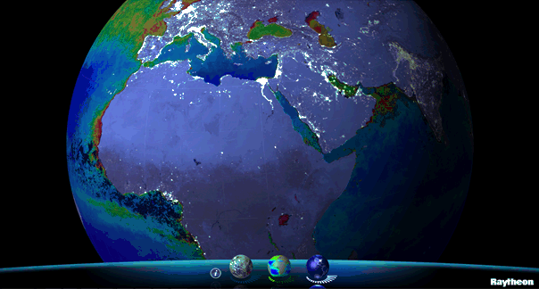
Available for iPhone, iPad and Android, VIIRS View provides mobile device users a look into the type of data meteorologists and climatologists use every day to track the weather and monitor Earth’s environment.
Based on data generated by the Visible Infrared Imaging Radiometer Suite aboard Suomi NPP, VIIRS View combines visible light imagery, low-light nighttime imagery and ocean chlorophyll concentration onto a full Earth globe, rotatable and zoomable on any location on the planet.
A desktop version of the VIIRS View app, launched in February, has been downloaded more than 90,000 times.
An original large format VIIRS View interactive tabletop display is being shown at Raytheon Booth #203 at the the 30th Space Symposium, being held this week in Colorado Springs, Colorado. GPS World Defense Editor Don Jewell is providing coverage from the symposium.
The app can be downloaded by searching VIIRS View at the Google Play and Android stores, or by clicking here:
It’s been two years since I wrote a column entitled Mobile Device Operating system wars: Android vs. iOS vs. Windows Mobile. After traveling and attending countless conferences and listening to a large number of mobile device users in the geospatial user community, I think it’s time to touch on this subject again, and what a crazy and confusing landscape it is. First of all, let’s frame the discussion in terms of the geospatial users, because that’s the soup we swim in.
At the end of the day, we are driven by the geospatial software we use, so this limits the type of mobile device we can select from. For example, Esri’s ArcPad runs on Windows Mobile and Windows desktop. If that’s the software you want to use, then you can’t use an Android device, an iPad, or a Windows Phone device. In another example, AutoCAD 360 for mobile, which I used a few weeks ago in the field, runs only on Android and iOS devices, not on Windows Mobile devices.
Chart Source: The Wall Street Journal, Gartner
While it appears Android is the dominant mobile operating system of the future, it depends on who you talk to. Right or wrong, some (maybe a lot of) enterprise organizations are scared of Android. They are scared because of one word: security, or more specifically, the perception of the lack of security. Android is open source, and it scares the heck out of enterprise IT (information technology) departments. It scares some to the point that they are shutting down projects that are proposing to deploy Android devices in the field. Is the fear justified? It’s probably more hyped up than it deserves, but IT folks are pretty conservative these days.
Where does that leave the enterprise organizations? iOS or Windows?
Some organizations are going with iOS, but the number of enterprise geospatial apps for iOS is very limited, and most of those that exist aren’t very powerful. They can’t even deal with datum transformations. That means the hardcore iOS enterprise users are left developing their own software, which some are doing. The other limitation of iOS is the hardware device selection. Since Apple doesn’t license iOS to anyone, you have the iPad and the iPhone and that’s about it. Not much selection.
That leaves us where we started…Microsoft Windows.
Dell Venue Tablet
My gut tells me that Windows is making a comeback among geospatial users, even though Windows operating system market share is minuscule compared to Android and iOS on mobile devices. Part of the reason is a plethora of high-quality, Windows-based tablets and pads. Recently, I’ve had the chance to handle some Windows-based tablets such as Dell Venue tablet and Panasonic ToughPad. They are nice tablets for field use. Thank Apple for driving manufacturers to produce good quality tablets at a reasonable price. The other part of the reason, and the major driver, is security. IT departments simply trust the security features that Microsoft provides more than iOS and Android. In the age of security breaches such as the recent Heartbleedbug, the emphasis on computer security is at an all-time high.
Panasonic ToughPad
Security may be the catalyst that pushes Windows back into the forefront of operating systems for the enterprise geospatial user. That’s good news for geospatial software developers. Pressure has been mounting for geospatial software manufacturers to introduce Android- and iOS-compatible versions of their software. Now, with the security issue at the forefront and the availability of high-quality Windows-based tablets at reasonable prices, developers may have some breathing space.
But wait: Which version of Windows?
Windows Mobile? Windows Phone? Windows Embedded Handheld? Windows Desktop? Windows RT?
They aren’t all the same, and they all don’t run the same software. For example, software built for Windows Mobile won’t run on Windows Phone or Windows Desktop.
Microsoft’s mobile operating system strategy has been confusing at best. In past years, it’s been clear that mobile devices run Windows Mobile. It’s not so clear any longer. Microsoft discontinued mainstream support for Windows Mobile 6.1 and 6.5 in January 2013. It’s not as bad as it sounds because in the three years I’ve owned a Win Mobile 6.5 Pro device, an update was never issued. But what it does say is that Microsoft is done with it. No new devices will be designed with Windows Mobile 6.5. However, that’s not to say that Windows Mobile devices are going away. Microsoft just renamed it to Windows Embedded Handheld 6.5, which Microsoft says it will provide extended support for until January 2020. So, all is well, just a different name.
Microsoft’s mobile strategy has turned off manufacturers, and it shows. Given that Microsoft has stopped supporting new devices running Windows Mobile since January 2013, how many devices have you seen introduced since then that support Windows Embedded Handheld? The answer is, not that many, and the ones that do support it are handhelds selling at a premium price, upwards of $1,500 or more. That’s tough to justify when you can buy a tablet or pad for equal or less. And…..the tablets and pads are running full Windows, not the mobile, handheld or phone version so they’re able to run a greater number of off-the-shelf software programs.
Given the above, I feel the tide is turning, at least for the geospatial user community. Windows is going to make a comeback and be the go-to operating system for mobile devices, at least for tablet and pad devices. Don’t misunderstand me though: Android and iOS will still dominate the market share numbers by far, but that’s the consumer user community, not the enterprise geospatial user community. Windows Mobile devices will still have a niche place in the geospatial user community, but I have to wonder if software makers will continue to support that environment if the sales aren’t significant enough.
Sidebar: For those of you who feel I’ve errantly left out the discussion about ruggedized devices vs. non-ruggedized or semi-rugged consumer devices, I’ll say this. Whenever I’ve encountered an enterprise that has deployed consumer mobile devices in an industrial environment (such as iPad), it invariably answers the question about device reliability with “We’ve had very few problems.” The reality seems to be that enterprise users are taking special care of these devices in the field. Program managers are saying, “Even if each person breaks one per year, it’s still half the price of industrial devices.” The reality is that small percentages are failing.
However, one can’t ignore the outdoor usability issue. The displays on some consumer devices don’t handle sunlight very well, and if the display isn’t sunlight readable, the device is severely limited in the field. The same can be said for wide temperature ranges. Both extreme heat and extreme cold can torture a mobile device that isn’t built to withstand that environment. Test before you deploy. Heat it up in your oven, cool it down in your freezer, and see how it behaves.
There’s certainly a niche market for ruggedized mobile devices, but the significant price difference between those devices and consumer devices are making enterprise organizations think twice about where to spend their money. Lastly, many consumer devices are trending towards semi-rugged as manufacturers are discovering this is one way to differentiate them from the ultra-price-competitive mobile device market.
When one talks about the worldwide location industry, mobile resource management — fleets and trucks, for instance — aren’t sexy at all, but they make money. What is supposed to be sexy is location-based advertising. According to many analysts, location-based advertising has been hampered by a few things: education for both consumers and mobile advertisers, privacy issues, and relevant proximity information so folks can use it to make purchases. Another concern could be the expense of rolling out indoor beacons.
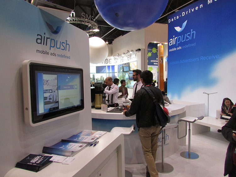
BARCELONA—Major consumer privacy concerns aside, companies are starting to see growth in location-based advertising, with new markets emerging in Europe. While the numbers of mobile advertising companies has decreased at the Mobile World Congress, held here in February, from just two years ago, the remaining players are seeing a more mature market.
Mobile advertisers are beginning to realize that location is the Holy Grail for growth, said Cameron Peeples, Airpush vice president of marketing. “People going into New York from Newark during rush hour can receive a different call to action because of a created geo-fence. Advertisers can determine whether the traveler is there on business or looking for a hotel and other travel deals,” he said.
Before Mobile World Congress, Los Angeles-based Airpush partnered with AirX, a large mobile ad exchange company. The majority of the AirX inventory, about 120,000 Android applications, includes highly-sought-after GPS location data, the company said.
There are large differences between the North American and European markets for mobile advertising, Peeples said. “The mobile advertising market [in Europe] is definitely evolving. The European market is key for us, dramatically higher than other markets,” he said. “[The European] market seems to have people connected to a lot of things — they are more mobile, use public transportation more, and always have a phone that is more centric to who they are.”
Making location-based advertising relevant to the consumer is still a major challenge. “Our focus next year is on native advertising. Native advertising combines not only the right message, but the right delivery vehicle,” Peeples said. “No one bicycling enthusiast wants ads tailored for someone who wants flowers.”
Peeples said the privacy issues are a big deal, but his company’s services are opt-in. “A lot of it is loyalty advertising. It’s all opt-in,” he said.
xAd Partners with Waze, Sees UK Growth
Another mobile advertising company, New York-based xAd, is also making inroads in Europe. “We are in the UK right now, which is really WiFi-focused. A lot of our early [location-based] advertising efforts are in education — to educate consumers and the advertising agencies about the power of location and mobile,” said Monica Ho, xAd vice president of marketing. “Not all location is created equal. The real value of [location-based advertising] is the proximity target to market to.”
Right before Mobile World Congress, Waze selected xAd as its third-party provider of search and display mobile ads in the United States. Waze, which was bought by Google in a deal worth more than $1 billion, is a top three map and navigation app in the iTunes store — a ranking that was probably helped by the Apple Maps debacle in 2012.
The companies say the deal will place xAd’s mobile ad targeting technologies into Waze’s location-based advertising platform.
Ho said there are still two areas of concern for location-based advertising: relevancy to the consumer and privacy issues. “There was privacy backlash from Nordstrom collecting consumer information from their Wi-Fi system,” she said, referring to the controversy last year when the retailer was accused of capturing consumer information during an indoor positioning test.
Apple to Roll out Upgraded Maps on iPhone 6
Speaking about Apple Maps, many industry analysts says the company has come a long way since the very public embarrassment nearly two years ago over map inaccuracies and flaws. The company recently released iOS 7.1, but is expected to rollout iOS 8 when the iPhone 6 debuts later this year.
With the debut of the iPhone 6, an updated version of Apple Maps will also be released, according to published reports.
Last year, Apple bought two companies, HopStop and Locationary, to allow the company to entrench itself once more in the location business. How firmly those roots prove to be, and how well they serve the company against archrival Google, remain to be seen.
Apple has been stockpiling companies and mapping software since its introduction of Apple Maps on iOS devices, which had a rough start. GPS World’s LBS Insiderreported extensively on the problems Apple encountered with its mapping software. Some of these problems included sending drivers to a wrong location and direction.
After the mapping software problems were made public, Apple CEO Tim Cook apologized for the mapping software’s problems and even suggested that users go to such competitors as Waze, MapQuest, and Microsoft’s Bing.
In other location news:
A Wall Street Journal reporter basically said there was nothing much new at Mobile World Congress — and that the excitement and action was at the outlying conferences at Fira Montjuic. One of these more interesting conferences, Four Years From Now, or 4YFN, featured start-up companies making pitches and displaying their new products, some of which included location capability.
The Mobile World Congress final stats. Organizers said MWC had more than 85,000 attendees from 200 countries — an increase of 13,000 from the previous year. It’s now being touted as the biggest and best wireless show.
In February, GPS World reported that TruePosition had purchased Skyhook for an undisclosed price. Skyhook provided location services to a number of companies including Apple and Samsung. The interesting issue is Skyhook’s lawsuit with Google, which alleged that the Internet giant influenced smartphone manufacturers to abandon the Boston-based company. According to published reports, the legal action still is going forward.
AT&T Mobility is shuttering its location-based Alerts marketing program. The company said it would release an updated version later this year. AT&T Mobility launched Alerts in late 2012. It featured free opt-in, location-based text message alert service. Participating retailers included Stapes, Gap, Zales, Neiman Marcus, and others.
I didn’t go to South by Southwest. Is my cool-guy card revoked? One of the reasons I didn’t is because, outside of meetings that were not part of the conference, there was not one location industry announcement made there. Maybe something will change my mind next year, but call me an old fogey — I just didn’t see the need to go to Austin this year.
GeoSpatial Experts’ GeoJot+ field data collection system now runs on Windows Mobile devices. According to GeoSpatial Experts, companies can seamlessly transfer GeoJot’s app component across Apple, Android, and now Windows Mobile 6.x devices such as Trimble and Juniper handheld GPS units.
GeoJot+ enables users to capture geotagged photos on mobile devices along with descriptive attribute information for each photo. The data is then automatically uploaded to the cloud and processed back in the office.
Using GeoJot+, organizations create reports and ArcGIS or Google Earth maps for managers and clients. GeoJot+ data is fed into a company’s backend database for further analysis and archiving. The system provides functionality from field data collection to final reports.
One subscription can now cover all Android, Apple, and Windows Mobile devices. Licenses can easily be transferred across operating systems using the GeoJot Administrator’s Dashboard, as they are not tied to specific devices.
“While smartphones and tablets are opening GIS mobile data collection to a larger audience, there are still many circumstances where people need higher GPS accuracy,” said John Clark, GeoSpatial Experts’ Director of Business Development. “With an intuitive interface and minimal training requirements, GeoJot+ now makes high-end GPS equipment more accessible to people outside of the GIS department.”
GeoJot+ meets a need for any organization requiring field asset inventory, proof of performance, compliance documentation, site assessments, situational awareness, or damage assessment. GeoJot+ captures location, condition and other data about real world conditions at a specific place and time.
This information helps companies solve business problems, gain competitive advantage, speed cash flow, and reduce expenses.


 This augmented reality (AR) navigation employs an AR-native framework, Apple’s ARKit. Blippar touts its AR City app for something it calls “urban visual positioning…which localizes users with higher accuracy than GPS, thanks to computer vision.” The app uses visual inertial odometry, interpreting movement seen through the camera, to minimize position errors, that is, in a sense, to correct GPS.