PassTime asset-tracking company has launched Encore 3, the third-generation of its wireless GNSS tracking platform.
Encore 3 builds upon the device platform introduced in 2019. It’s low power consumption results in extensive battery life, as much as several years. It can select and switch among four power modes so that customers can choose the features and reporting frequency they desire while balancing the battery-life options that meet their business objectives.
The compact Encore platform is self-powered, offering customers the ability to place an Encore device on an endless number of mobile assets within seconds. An optional, external power cable can be used to enhance the device’s functionality even further. Encore 3 features an updated, modern USB-C connector for the optional external cable, for improved ease of use and connectivity.
Encore 3 is built with Cat-M1 LTE cellular technology for connectivity and provides 5G compatibility.
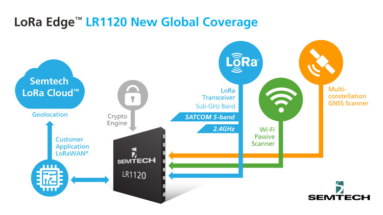
The new LoRa Edge LR1120 enables satellite-based networks and simplifies terrestrial network interoperability
Image: Semtech
Semtech Corp. has added multi-band capabilities to its LoRa Edge device-to-cloud geolocation platform.
The LoRa Edge LR1120 allows for direct satellite-connected internet of things (IoT) applications in supply-chain management and logistics with seamless low-power geolocation on a global scale, the company said.
“Semtech’s LoRa is targeting track and trace challenges faced by the logistics industry today with a geolocation IoT platform adapted to global transportation and mass-scale asset management,” said Marc Pégulu, vice president of IoT product marketing for Semtech’s Wireless and Sensing Products Group. “With the launch of multi-band LoRa support, coupled with LoRa Cloud services, it has never been easier to expand ubiquitous IoT connectivity and geolocation globally.”
With LoRa Edge LR1120, intercontinental logistics companies can leverage highly integrated, ultra-low-power trackers with enhanced interoperability, more versatile connectivity for a simpler operation, and global mobility across multiple regulatory regions, Semtech said. Additionally, the possibility to offer a low-power and low-cost sensor with satellite connectivity unlocks a multitude of use cases in infrastructure monitoring, agriculture and environmental monitoring that require deployment in remote areas, which tend to be capital intensive.
“Combining LoRa with small, relatively low-cost LEO satellites will change the game for LoRa and IoT,” said Christopher Taylor, director, RF & Wireless with Strategy Analytics. “Adding satellite communication capabilities in the S-band to LoRa can help replace aging SCADA monitoring and opens up new applications and markets, especially in remote regions. So far, LoRa has attracted the interest of several satellite companies including EchoStar and Lacuna.”
Key Features of LoRa Edge LR1120:
multi-band LoRa capability (sub-GHz, 2.4 GHz and licensed S-band for satellite) and multi-technology geolocation using GNSS for outdoor and Wi-Fi for indoor, as well as areas where satellite coverage is poor
LoRa Cloud geolocation solver, which transfers the location processing workload from the device to the cloud, making “deploy once” battery life possible
RedLore has launched a high-resolution version of Locus Site, its patented solution for high-accuracy onsite positioning. The real-time location system (RTLS) pinpoints assets down to one-half foot or 15 cm without requiring wiring throughout the facility.
Locus Site provides high-accuracy tracking for companies and facilities where installing wires is not possible. A 200,000-square-foot facility can be equipped with positioning capability in one day.
“The world’s logistical processes are today stretched to the breaking point,” said RedLore CEO Niek Van Dierdonck. “Keeping track, in real-time, of the location and condition of assets onsite and during loading and unloading provides an immediate improvement in efficiencies. Locus Site offers exactly that at a fraction of the cost and burden of other systems.” The system uses wireless sensors and asset tags, configured with a desktop app and supported by a mobile app.
Locus Site is used by manufacturers, healthcare service providers, construction companies, logistics companies and others to track everything in their facility without manual intervention.
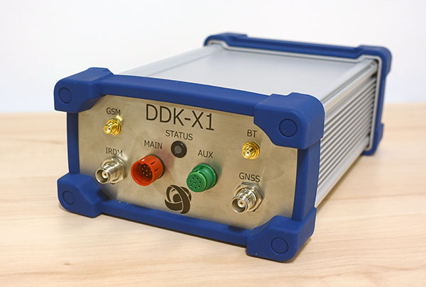
Oceaneering International Inc. and DDK Positioning Limited have entered into an agreement for the provision of GNSS augmentation service and all associated software and hardware supporting Oceaneering’s C-Nav Positioning Solutions group offerings.
Oceaneering provides engineered services and products primarily to the offshore energy industry. C-Nav uses precise point positioning corrections with worldwide accuracy of better than 5 cm horizontally and 15 cm vertically.
DDK Positioning’s services are delivered through the Iridium satellite communications network coupled with hardware developed by partner Topcon. This pairing will enhance the ability of Oceaneering’s customers to precisely position their assets globally. The unified solution offers several benefits to Oceaneering’s positioning customers, such as two-way communication enabling machine control and feedback, and redundancy to cover potential signal losses.
From launch, DDK Positioning will provide its MAX service to Oceaneering clients, which can achieve accuracy to less than 10 cm (2 sigma). The MAX service uses GPS, Galileo, and GLONASS constellations with further systems to be added within a year.
“Significant advances have been made in communications infrastructure and satellite positioning technology over the last several years,” said Eric Smith, director of Survey Services at Oceaneering. “With this agreement, Oceaneering will be able to offer enhanced positioning technology allowing us to build on our strong industry track record while continuing to serve the positioning needs of our clients now and into the future.”
“We are absolutely delighted to have signed an agreement with Oceaneering to provide our precise and reliable GNSS positioning solution to Oceaneering’s customers in the maritime energy industry,” said Kevin Gaffney, CEO at DDK Positioning. “This agreement demonstrates the need for an alternative GNSS augmentation service that increases the reach of services from pole to pole, with the added benefit of Iridium’s resilience and reliability.”
Rx Networks has added a new extended ephemeris service called StarCourse.
According to the company, real-time ephemeris services provide GNSS chipsets in connected mobile devices a headstart in determining position accurately and quickly. For devices with limited connectivity, typical extended ephemeris solutions have provided a headstart with 7-14 days of ephemeris data.
With the evolution of the internet of things (IoT), low power consumption and a limiting of connection time are essential for extending the usable life of a device. This creates a challenge for IoT vendors seeking an extended ephemeris offering that can minimize onboard resource usage without compromising accuracy.
The new StarCourse service provides a 50% reduction in RAM requirements, 90% reduction in CPU cycles, and ephemeris accuracy exceeding that of previous market offerings. This empowers Rx Networks customers to extend the usable life of their products while delivering an excellent positioning experience, the company said. Full data customization is offered to StarCourse subscribers, allowing them to create optimal solutions for their needs.
StarCourse enables autonomous positioning on a wide array of connected GNSS IoT devices, including asset tracking, wearables, in-dash navigation and mobile devices. For situations where accuracy is paramount, StarCourse Premium provides ultra-precise predicted ephemeris for the first 24 hours.
“GNSS assistance services are essential to solving the spatial intelligence requirements of the booming IoT world,” said Chris Perriam, product owner at Rx Networks. “StarCourse endeavours to quickly enlighten all connected devices with location.”
Rx Networks provides location information to strengthen the connection between people, devices and businesses by improving the GNSS experience and creating enhanced opportunities for next-generation products and services.
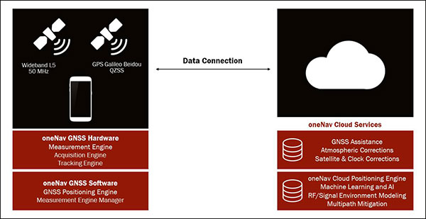
Using artificial intelligence (AI), the oneNav receiver improves accuracy and reliability for location-dependent applications and services.
A new L5-only GNSS receiver is now available from oneNav. The mobile receiver provides high location accuracy with half the footprint of existing solutions.
OneNav has signed a strategic partnership agreement with In-Q-Tel Inc., providing U.S. intelligence and defense agencies with a GNSS technology solution that is the first of its kind, according to the company. The company also closed a $21 million Series B funding round, led by GV, with participation from Norwest Venture Partners and GSR Ventures, bringing total funding to $33 million.
“Navigation satellite constellations are getting a major upgrade — L5 signaling. oneNav has built the first Pure L5 mobile receiver to leverage these modernized signals, and we will deliver our solution in a flexible licensing model, as a scalable and customizable IP core,” said Steve Poizner, co-founder and CEO of oneNav. “I’m proud to be working with such an outstanding team of GNSS experts, as well as our top-notch investors GV, Norwest and GSR.”
“Pure L5 is a more cost-, size- and power-efficient method to enable the benefits of modernized signals compared to current hybrid solutions,” added Paul McBurney, oneNav co-founder and CTO.
Other GNSS solutions that fuel location-based services — rideshare, smartphone navigation and 911 emergency calls — depend on L1 satellite signals developed in the 1970s. According to oneNav, legacy L1 systems can have significant accuracy deficiencies, especially in dense urban areas, placing users on the wrong side of the street or on the wrong block.
L1 signals are also susceptible to jamming. Recently, satellite constellations have been upgraded with state-of-the-art L5 signaling. L5 enables higher accuracy, broadcasts in a protected frequency band, has modern error correction and is transmitted at higher power.
OneNav’s Pure L5 solution is built from the ground up to fully leverage modernized L5 signals from the GPS, Galileo, Beidou and QZSS navigation satellite constellations. Unlike current L1+L5 hybrid solutions that must first acquire on L1, oneNav’s Pure L5 solution both acquires and tracks on the new L5 signals, without L1 aiding, thereby taking full advantage of L5 benefits.
By eliminating the need for L1 circuitry, oneNav cuts GNSS RF size, power and cost in half. Supercharged by AI/machine learning, oneNav Pure L5 delivers much higher accuracy, even in challenging areas such as urban canyons. OneNav Pure L5 is ideal for highly space-constrained devices such as smartphones, wearables and IoT tracking modules. The solution is delivered in a semiconductor IP license package that includes register-transfer level (RTL), software and reference designs that can be integrated into a system on a chip (SOC) or built as a discrete chip.
The oneNav L5 mobile GNSS system architecture. (Image: oneNav)
Pure L5 Use Cases
OneNav’s technology will dramatically improve location-based services that are used every day by individuals across the world to pinpoint their location. Common use cases include:
Rideshare. Today’s mobile positioning technologies often place users on the wrong side of the street, or on the wrong block, making rideshare services very difficult to use. oneNav enables riders to more effectively match up with their drivers in downtown areas and other heavily blocked environments.
Smartphone Navigation. It is sometimes difficult to establish your exact location, or to determine which way to turn when using a mobile navigation application in a dense urban area. oneNav’s high availability and precise accuracy enables reliable turn-by-turn directions.
Emergency Calls. First responders need to accurately pinpoint the location of accidents in order to get to the right place quickly. oneNav’s reliable positioning and high accuracy get the right location information to ambulances, fire and police, enhancing public safety.
Asset Tracking. COVID-19 has increased the need for supply-chain assets to be transported and tracked with precision. oneNav enables accurate position reporting for asset tracking and other IOT applications.
“The mobile device industry — from phones to wearables — has made tremendous progress over the last 20 years,” said Karim Faris, GV general partner. “What’s surprising is that location-based services continue to have a significant margin of error, which can make all the difference when locating a rideshare passenger or pinpointing an emergency situation. With oneNav’s Pure L5 Mobile GNSS receiver, OEMs and application service companies will have the opportunity to provide their customers with state-of-the-art location-based services, driving competitive advantage.”
DDK Positioning’s precise GNSS positioning solution provides an accuracy of less than 5 cm
NSSLGlobal has entered a strategic alliance with DDK Positioning, to incorporate enhanced GNSS positioning navigation and timing solutions into NSSLGlobal’s maritime portfolio.
NSSLGlobal will now provide, install and service DDK’s GNSS precise point positioning (PPP) solution which enhances the ability of NSSLGlobal’s customers to precisely locate and track their assets.
DDK’s independent GNSS technology is provided exclusively through Iridium’s global satellite constellation, and creates a robust, resilient and completely independent GNSS solution that has an enhanced accuracy of less than 5 cm, compared to the standard GPS accuracy of 10 m.
“This partnership is a fantastic fit for DDK Positioning,” said Kevin Gaffney, DDK Positioning CEO. “We are now in a place to provide our clients with our precise positioning solutions globally and we are delighted to formalize our working relationship with NSSLGlobal with the signing of this new strategic alliance.
Photo: DDK Positioning
“To continue the journey with such a strong and well-respected company such as NSSLGlobal, and with their reach in the market, makes great sense and we are looking forward to the journey that we will have together.”
“DDK Positioning is leading the field in advanced GNSS positioning,” said Paul Rutherford, service director, NSSLGlobal. “We’re pleased to partner with such an innovative company and to be able to add this technology offering on top of the already extensive navigation and communication portfolio we offer our customers. The system will provide greater location accuracy, along with the ability to help detect and mitigate spoofing.”
A new enterprise platform available this summer provides real-time location and asset tracking across a campus with Bluetooth technology.
Link Labs’ AirFinder OnSite is an internet of things (IoT) asset-tracking platform for campus-based environments. Using a Bluetooth Low Energy (Bluetooth LE) radio to support both Bluetooth LE and phase ranging brings location accuracy with Bluetooth LE tags to the sub-meter level.
According to Link Labs CEO Bob Proctor, AirFinder OnSite eliminates the need to choose between high-cost/high-accuracy ultra-wideband solutions or low-cost/low-accuracy traditional Bluetooth LE solutions.
Proctor sees it potentially used in distribution centers and warehouses, as well as IoT applications in manufacturing, healthcare and logistics management. With seven patented or patent-pending Link Labs technologies, AirFinder OnSite was developed on Nordic Semiconductor’s nRF52833, a general-purpose multiprotocol system-on-chip with a Bluetooth LE direction-finding-capable radio.
Innovations at the firmware level solve an array of technical challenges for an enterprise-grade solution: ranging methodology, interference avoidance, a location algorithm, power efficiency and scalability to high-tag densities.
These innovations allow asset location to be fine-tuned to the sub-meter level, making it a precise Bluetooth-based location technology.
AirFinder does not require an internal Wi-Fi system and is capable of operating on its own secure network layer via Link Labs’ Symphony Link or other third-party network layer technology, such as Bluetooth mesh technologies. The AirFinder platform provides remote monitoring and device management, allowing the system to be optimized for different use cases.
This spring, early adopters will support pilot deployments of AirFinder OnSite.
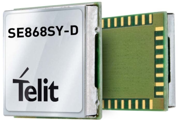
Telit has launched the SE868SY-D multi-frequency, high-precision GNSS receiver module for applications that require high accuracy, fast updates, multi-constellation support and multipath resistance.
At 11 x 11 mm, the SE868SY-D accommodates ultra-compact devices and IoT trackers.
Available now, the high-precision SE868SY-D module is Telit’s first multi-frequency, multi-constellation GNSS receiver module, featuring an ultra-sensitive -167 dBm (tracking) RF front end. By using both the L1 and L5 bands, the SE868SY-D supplies a significantly higher location accuracy than single-frequency devices — even in high-multipath environments such as urban canyons, Telit said.
This sub-1-meter precision is a major reason ABI Research expects more than 1 billion multi-frequency GNSS devices to ship annually by 2023.
The SE868SY-D is the first product from a new strategic collaboration between Sony and Telit, and features Sony’s next-generation CXD5610 GNSS receiver large-scale integrated circuit (LSI).
The Telit SE868SY-D is designed for battery-powered applications such as IoT trackers and wearables. With less than 45 mW in L1+L5 tracking mode, the module has low power consumption, despite using both L1 and L5 bands.
For high-dynamic applications, the SE868SY-D a high update rate of up to 25 Hz. Its high-accuracy, one-pulse-per-second signal also makes the module suitable for timing applications.
“With the new SE868SY-D, Telit is uniquely prepared to meet the burgeoning global demand for multi-frequency, multi-constellation GNSS receivers for IoT trackers, wearables and more,” said Eric Lagorce, Telit business development director. “The SE868SY-D also perfectly complements Telit’s two decades of GNSS expertise and its broad portfolio, and highlights the potential of our strategic collaboration with Sony.”
The Telit SE868SY-D provides pin-to-pin compatibility for applications based on Telit’s legacy GPS module JF2 and GNSS module SE868V3.
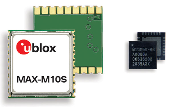
M10 receiver platform can track four GNSS constellations, even in challenging environments
Photo: u-blox
U-blox’s new M10 GNSS platform is designed for ultra-low-power high-performance positioning applications such as sport watches and asset trackers.
The M10 positioning platform can track up to four GNSS constellations at once to deliver positioning data even in challenging environments such as deep urban canyons. The receiver’s Super-S technology helps distinguish positioning signals from background noise to capture positioning data even when satellite signals are weak.
Its high RF sensitivity also enables it to work well with small antennas, making it suitable for compact product designs. In sport watches, for instance, u-blox M10 guarantees highly dynamic positioning accuracy during a run in cities, woods or under an open sky, while preserving battery life.
Low power consumption. The u-blox M10 is designed to consume 12mW in continuous tracking mode, five times less than the power consumed by previous u-blox meter-level GNSS technology, making it beneficial for battery-powered applications.
U-blox M10’s enhanced RF sensitivity also cuts the time it takes for the platform to achieve a first position fix when initialized, further reducing systemic power consumption. And switching to the improved Super-E mode can extend battery life even more.
This new GNSS platform will be supported by AssistNow, u-blox’s assisted GNSS service, to accelerate positioning and improve accuracy. Depending on the required level of assistance, the service is available free of charge or for a recurring fee.
Jamming detection. The u-blox M10 platform benefits from u-blox’s experience in building robust GNSS receivers, incorporating proven techniques for detecting spoofed signals through the analysis of raw GNSS data, jamming-detection strategies, and embedded filters to mitigate the effects of in-band RF interference.
“U-blox can be proud of over 20 years of experience with GNSS technology, and with u-blox M10 we are setting a new benchmark in ultra-low power high performance positioning applications,” said Bernd Heidtmann, product manager, Product Center Positioning, u-blox. “We have increased concurrent reception of satellite signals by a GNSS platform from three to four constellations and improved the power consumption level five-fold compared to previous generations while shrinking the chip size by 35 percent.”
U‑blox has launched a commercial internet of things (IoT) Security-as-a-Service offering. Available on both the u‑blox SARA-R4 and SARA-R5 series of LTE-M cellular IoT modules, the service protects data from malicious third parties, both on the device and during transmission from the device to the cloud, u-blox said in a press release.
Both the SARA-R4 and R5 have integrated M8 GNSS receivers.
The IoT Security-as-a-Service provides an out-of-the box onboarding process to cloud IoT platforms to speed up development, shortening time-to-market.
The IoT Security-as-a-Service offering, which is managed via the u‑blox Thingstream service delivery platform, is specifically optimized for low-power, wide-area (LPWA) deployments that use resource-constrained IoT devices. By substantially reducing data overhead and keeping the number of handshakes to a minimum, the service improves power consumption and extends the battery life, a critical metric for most IoT devices.
u-blox acquired Thingstream, an IoT communication-as-a-service provider, in April.
Central to the effectiveness of the solution is a unique symmetric key management system (KMS). Through it, an infinite number of crypto keys can be generated on the fly for each device, rather than having to rely on the storage and management of pre-shared keys (which can add to overall operational complexity and the power budget).
Keys are tied to the hardware and can be triggered from either the module or from the server/cloud, completely eliminating the need to create, deliver, and renew certificates, and bringing significant savings in terms of system cost, operational complexity, and power consumption.
The solution also leverages u‑blox’s Foundation security offering, which comprises fundamental elements that make SARA-R4 and SARA-R5 modules secure by design. These include a unique and immutable device identity that is tied to its root of trust (RoT), which forms the basis for a trusted set of advanced security functionality, including a secure boot mechanism that ensures that the module can only run trusted software. In addition, u‑blox’s proprietary uFOTA feature enables authentication of over-the-air firmware updates.
Among the relevant use cases that u‑blox IoT Security-as-a-Service can support are:
Asset tracking. Data authenticity is essential in such scenarios, as well as secure local storage of collected data and easy secure cloud onboarding. Because tracking devices are usually battery powered, they require extremely energy-efficient secure data transmission.
Connected health/eHealth. In this use case, patient confidentiality is paramount, with only authorized medical staff permitted to access sensitive data. This necessitates a high degree of protection against malware and data tampering.
Industrial monitoring. These solutions need to guarantee the integrity of real-time operational data to increase productivity, avoid downtime, and assure the safety of the workforce.
Building and home automation. Data confidentiality and authenticity need to be maintained, while allowing for data to be shared with trusted stakeholders without compromising customer privacy.
Telematics. In this scenario, the main security risks include denial-of-service (DoS) attacks, device cloning, jamming, etc.
Smart metering. Here, the authenticity of data logged by remote metering units needs to be confirmed to protect billing, and, once trusted communication is established, data transmission needs to be restricted to authorized servers.
“We implemented a true end-to-end concept that protects data from the device to the end user without making it visible to intermediate nodes or platforms, or to service providers. The modules’ symmetric KMS offers engineers a streamlined and scalable alternative to conventional public key infrastructure or pre-shared key arrangements,” says Giovanni Solito, senior product manager, Product Center Services at u‑blox. “And with straightforward onboarding to all the popular cloud IoT platforms, efforts are not taken up by security concerns and operational complexities, but can be focused on speeding up time to market and growing business.”
Telematics company SkyBitz has announced a strategic technology partnership with fleet logistics solutions provider Coretex. The partnership combines Coretex sensor-based refrigeration solution and cloud-based software platform with SkyBitz trailer tracking technology to create a complete solution for businesses needing both powered and non-powered asset tracking.
With the partnership, food, pharmaceutical and retail customers can have total visibility into the status of loads during transportation, resulting in improved food safety and quality assurance.
The SkyBitz and Coretex partnership allow customers to access and manage both reefer device data and trailer tracking data via one seamless solution, enabling greater insight, a more transparent view of their entire cold chain operation, and better decision making. Customers can now automate Food Safety Modernization Act (FSMA) compliance, allowing them to keep assets on the road for longer, monitoring them with advanced temperature tracking capabilities.
“Our customers look to us for innovative, value-driven solutions that help improve profits across their entire operation,” states Henry Popplewell, DVP and president of SkyBitz. “As leaders in the supply chain and logistics arena, we are excited to capitalize on this partnership to continue to grow our cold chain customer base and align ourselves with the foodservice industry through this technology partnership. The Coretex pedigree in last-mile food and beverage distribution is the perfect complement to our asset management technology.”
With this new offering, customers of Coretex and SkyBitz will benefit from the following:
More than 50 features of remote cold chain monitoring capabilities, including two-way reefer control, monitoring of up to six doors, and advanced power management to preserve reefer and telematics unit battery life.
Single point of access to critical and timely best-in-class trailer utilization and reefer information on one seamlessly connected platform, greatly expanding productivity and streamlining operations.
Communication between the trailer and other connected sensors with options to expand to additional Coretex products such as assurance solution CoreTemp.
An unmatched compilation of integrated driver safety, compliance, and asset management tools including the Coretex integration with trailer braking solutions and automatic tire inflation systems.
“Combining SkyBitz leading trailer and asset management technology with Coretex cloud-based software platform, two-way reefer solutions, and deep compliance capabilities create a powerful solution for both companies,” said Coretex CEO Selwyn Pellett. “At Coretex, reefer solutions have been a core part of our business for 16 years, and we’re excited to share our experience with SkyBitz. The trailer expertise of SkyBitz complements our offering, perfectly creating a solution that can help businesses increase the productivity of their assets. With the growing importance of food safety assurance for both food producers and distributors, we think both companies’ customers will find our combined fully-featured solution the best on the market.”