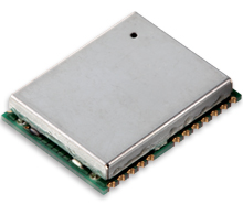
KCS BV has upgraded its successful TraceME module TM-178, targeted for tracing and controlling vehicles and other powered equipment.
The TM-178/R9H7 module has been upgraded with optional LoRa, Wi-Fi, Bluetooth Smart (BLE), ANT/ANT+ and proprietary RF, which enables easy integration with existing wireless networks and specific custom mobile apps on smartphones and tablets.
The LoRa technology offers a communication range up to 60 kilometers line of sight. The module offers an advanced indoor and outdoor location-based positioning solution, which covers a variety of Internet of Things (IoT)-applications and enables stolen object and vehicle recovery.
The TM-178 is equipped with external power and battery backup connection, basic I/O-connectivity and multiple onboard sensors. The unit contains multiple integrated antennas for GPS/GLONASS, GSM (2G/3G) and RF functionality. The functionality of the module can be remotely programmed to fit any job, from basic/general functionality to advanced/low-level application-specific detailed functionality.
With a compact size of 91 x 40 millimeters, weight of 30 grams, and a battery lifespan of more than 10 years, the module offers endless OEM integration possibilities. Optionally, the module can be ordered in a robust IP67 housing.
Eight million GPS/wireless devices are used to manage fleet vehicles, trailers, construction equipment and mobile workers, according to a new report by C.J. Driscoll & Associates, a supplier of telematics market research and consulting services.
According to the “2016-17 U.S. Mobile Resource Management Systems Market Study,” by 2019 this market will expand to more than 14 million units, and annual hardware and service revenues will grow to nearly $4.7 billion.
Growth has been strong in the local service and delivery fleet market, where the use of commercial telematics solutions is expanding at a rate of 15-20 percent per year. However, the trucking sector’s rate of growth is projected to exceed the local fleet market because of the recently issued regulations requiring the use of Electronic Logging Devices (ELDs) by interstate trucking fleets for monitoring driver hours of service.
While the largest GPS fleet management companies are becoming increasingly dominant, this has not discouraged new players from entering the market, some with considerable success. Overseas suppliers also continue to be drawn to the U.S. market due to its size and rate of growth.
The 323-page market study provides in-depth information on each major MRM market segment, including the markets for vehicle-installed GPS fleet management solutions for local service and delivery fleets and long haul trucking fleets. The market for driver behavior management systems is also examined, along with the emerging market for managing mobile workers with GPS-equipped smartphones and tablets. In addition, the study covers the markets for monitoring mobile assets, such as fleet trailers and heavy equipment.
The study assesses the current market penetration of MRM systems and services and projects annual subscriber and revenue growth through 2019. Detailed profiles are provided on more than 140 suppliers of MRM systems and services, including target markets, key features, installed base and pricing.
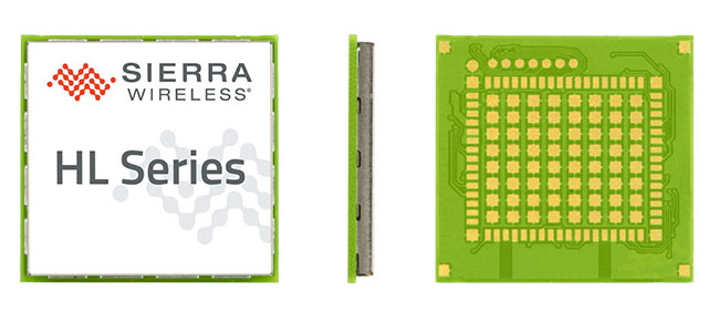
Maestro Wireless Solutions Limited, a provider of tracking devices for Internet of Things (IoT) applications globally, has announced its first LTE Cat-1 tracker based on the AirPrime HL Series from Sierra Wireless.
Maestro’s newest tracker, the ruggedized MT-44, provides fleet and asset tracking capabilities in harsh mobile environments using the LTE Cat-1 module with maximum data rates of 10 Mbps downlink and 5 Mbps uplink.
The Maestro MT-40 Series is a compact range of rugged micro-trackers for the vehicle tracking market.
“We have been integrating Sierra Wireless modules into our products for more than 15 years and we have always trusted the company to deliver on leading edge cellular technologies that improve product performance,” said Xavier Dupont, chief executive officer of Maestro. “The HL Series provides us with a single footprint for 2G and 3G global coverage and the LTE Cat-1 module is utilizing the same compact design in our newest tracker.”
“Today, we are seeing strong interest in our LTE Cat-1 embedded modules optimized for lower bandwidth and power requirements,” said Dan Schieler, senior vice president, OEM Solutions for Sierra Wireless. “We are pleased to have Maestro deploying our latest LTE technology in their tracking devices. The HL Series Cat-1 module provides the next step in the evolution for our customers, as service providers are continuing to transition their networks to LTE technology.”
The HL Series uses the CF3 form factor from Sierra Wireless that is footprint-compatible across product lines and network technologies, and is fully interchangeable with future versions of the modules, including LTE-M variants when they become available.
LTE-M is a Low-Power Wide Area (LPWA) technology that will provide a highly efficient cellular option with lower radio-frequency complexity, significantly reduced power consumption (up to 10 years of service on a single AA battery), better in-building signal penetration and lower costs. Sierra Wireless is an active contributor to the LTE-M standard definition process within the 3GPP and has committed to launching compatible modules timed with network deployments, expected to begin in 2017.
The LTE Cat-1 modules from Sierra Wireless will be commercially available in January 2016 on the HL Series.
The AL3RT asset tracker is designed for the power sports industry and runs on the AT&T network.
Kika Enterprises announced at CTIA Super Mobility this week that its AL3RT asset protection unit will be available as an accessory for Polaris electric bikes worldwide, beginning January 2016. The AL3RT trackers will be sold at sports dealerships in the United States.
Powered by AT&T, AL3RT is a stand-alone, customizable asset locator and fleet management tool designed for theft protection of on- and off-road vehicles, motorcycles, snowmobiles and personal watercraft.
AL3RT customer benefits include: real-time location alerts, anti-theft alerts, accident panic alerts, historical location data, coverage in locations around the globe, long battery life (up to seven days) and a water- and dust-proof housing. The product line will also include several accessories, such as a multi-use cradle for easy mounting and Bluetooth multi-sensors that can be programmed individually.
Supported by GPS, GSM, Wi-Fi and Bluetooth technologies, users can use their AL3RT smartphone app to locate their asset, as well as arm and disarm sensors and configure geofences virtually anywhere in the world. AL3RT can be configured to send individual or group alerts via email or SMS.
“We are excited about the launch of the AL3RT, because it represents the first true anti-theft alert solution designed for the power sports industry,” commented Ricardo Salguero, president of Kika M2M. “The AL3RT offers superior features, reliability and AT&T connectivity, making it a tremendous extension of our growing line of customizable M2M solutions. This addition truly positions Kika M2M uniquely in the market with a broad range of proprietary M2M solutions for the power sports industry.”
Kika M2M will showcase the AL3RT at CTIA Super Mobility, taking place Sept. 9-11 in Las Vegas, as a part of AT&T’s Booth #3724.
Telit, a global enabler of the Internet of Things (IoT), today announced that Cellocator, a Pointer Telocation division, has selected the Telit IoT Platform as the underlying IoT Cloud infrastructure for its new CelloTrack Nano system. The platform, powered by deviceWISE, automatically performs all the critical connection, management and integration functions to simplify deployments of the Nano system across markets and industries worldwide.
The CelloTrack Nano system enables real-time status monitoring of goods in transit. That includes location and a variety of critical operational sensing of the cargo or asset in real time, using a portable hub and a short range Wireless Sensor Network (WSN). The sensors monitoring capabilities include temperature, humidity, light, pressure, impact, movement, tampering and sound. It ensures continuous recording, enables event-triggered logic and “management by exceptions” through flexible programming of business rules to eliminate supply chain mistakes, avoid delays or damages and reduce insurance expenses.
“We see high demand for the CelloTrack Nano in our traditional markets and count on Telit’s platform to bring us to the new IoT market,” said Joshua Rozanski, VP sales & marketing, Pointer Telocation. “By using the scalable, comprehensive Telit IoT Platform, Pointer has been able to concentrate on the rapid creation of a compelling, market-driven end-to-end solution.”
“Pointer has been a valued customer of Telit’s modules for almost a decade and we are pleased that they have now also selected the Telit IoT Platform as the go-to-market technology solution for their newly announcement Nano system,” said Gideon Rogovsky, SVP of Sales and Marketing, Telit IoT Platforms. “The deviceWISE Ready certification offers CelloTrack Nano instant exposure across our thriving deviceWISE ecosystem and opens instant opportunities with our global network of business partners and customers.”
The Telit IoT Platform connects “things” to “apps” — integrating any devices, production assets and remote sensors with web-based and mobile apps and enterprise systems. The platform reduces risk, time-to-market, complexity and cost of deploying solutions for monitoring and control, industrial automation, asset tracking and field service operations across all industries and market segments around the world. The Telit IoT Platform offers extensive developer resources and support and a free trial can be accessed here.
This photo shows drifting icebergs from the Amundsen during research expedition. (Photo: courtesy of Greg McCullough, University of Manitoba)
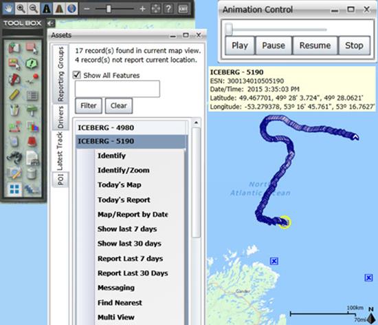
A Canadian expedition team used GeoDecisions’ GeoILS platform to help track icebergs during a voyage to better understand how icebergs drift. An intelligent location server using the EsriArcGIS platform, GeoILS enables users to monitor and locate assets and facilitate quick and coordinated responses.
GeoDecisions, an information technology company specializing in geospatial solutions, partnered with Solara Remote Data Delivery Incorporated, Canada’s Carleton University and Esri during the project.
Led by University of Manitoba Scientist David Barber, the crew of Canadian Coast Guard Icebreaker Amundsen sailed off the coast of Newfoundland and Labrador to research ice hazard mitigation, the effects of climate change, and polar region technology requirements. GeoILS location intelligence helped crew members visualize, analyze, and leverage project-pertinent data.
“During the expedition, researchers and scientists used GeoILS to assess drifting through sensor monitors attached to the icebergs,” said Brian Smith, vice president of commercial solutions with GeoDecisions. “In addition to reporting and notifications, GeoILS provided the project team with maps that were tailored by selecting desired iceberg information and the geographic area of interest based on user-defined criteria.”
Above is a representative snapshot of GeoILS’ features and range of functionality used during the Canadian iceberg expedition.
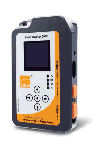
GeoDecisions’ data portal was used with Iridium Solara tracking devices during the iceberg research project. “We are excited to provide tools to scientists who are gaining critical insights into the behavior of icebergs and global climate change,” said Tom Tessier, president of Solara Remote Data Delivery Incorporated.
Solara Field Tracker 2000.
“GeoILS and the satellite tracking beacons worked very well during this project,” added Derek Mueller, assistant professor and physical geography program supervisor with Carleton University. “Thanks to our partners’ efforts, we now have a great new suite of tools for examining our data.”
The GN-87 multi-GNSS receiver by Furuno Electric Co.
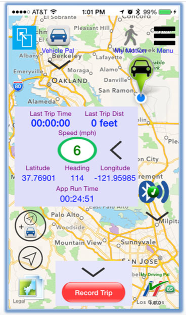
Furuno Electric Co.’s latest multi-GNSS receiver module, the GN-87, has been adopted for use in the new My Driving Pal (MDP) device.
The MDP device and app communicate with each other via Bluetooth low energy (BLE). When the MDP device and a phone running the MDP app are within range of each other (approximately 15 meters), the device keeps its internal GPS in idle mode. When the phone is out of Bluetooth range and the object that is carrying the MDP device is moving (for instance, under the seat of a stolen bicycle or in the pocket of a wandering child), the MDP device activates its built-in GNSS receiver and cellular modem, tracks the asset, and immediately notifies the user on a phone via remote push notification.
The range is unlimited, because the MDP device will track the asset anywhere in the world, with an accuracy level of meters. To protect user’s privacy, all tracking data remains locally on the phone and is not transmitted to any backend server.
In April, the GN-87 receiver was adopted for the new quadcopter Bebop Drone, made by Parrot SA. The GN-87 provides positioning accuracy and smooth ground tracking because of its multi-GNSS technology, which allows it to receive more satellite data even in harsh environments such as urban canyons.
My Driving Pal (MDP) is a technology startup based in Silicon Valley that develops advanced Internet of Things solutions. MDP’s mission is to improve road safety by enabling vehicle to vehicle and vehicle to infrastructure communications. A small percentage of new vehicles are connected, but still the vast majority have no connectivity, not including motorcycles and bicycles. The MDP product delivers a suite of security, monitoring, and tracking applications, from delivering remote notification on phone if interior temperature of car gets too high, to automatically tracking the bike, if it’s ever stolen.
For more information on the MDP device (capabilities, availability, distribution, retail or partnerships), send an email to [email protected], or follow MDP on Facebook.
Jamming Signals Criminal Activity in Intermodal Ports
By Logan Scott
More than 25 million containers pass through U.S. intermodal ports every year, with port operations valued at more than $1 billion per day. Measured in 20-foot equivalent units (TEU), the World Bank reports that worldwide, more than 600 million TEU passed through intermodal ports in 2012: 155 million through Chinese ports, 95 million through the EU ports and 43 million through U.S. ports.
The Port of Long Beach alone handled 6,820,806 TEU in 2014. GPS is a central component of automated port operations, but because GPS is widely used in asset tracking and monitoring, it has also become a target for denial-of-service attacks. If we look to the history of computer security, the initial attacks were mostly nuisances, but as criminals figured out how to monetize attacks, the attacks became more damaging, more sophisticated and more profitable.
In January, the U.S. Coast Guard held a public meeting on Maritime Cybersecurity Standards at Department of Transportation headquarters in Washington, D.C. Brett Rouzer, chief of Maritime Critical Infrastructure and Key Resources Protection, Coast Guard Cyber Command, described how a major East Coast intermodal shipping facility was degraded by a GPS disruption for more than seven hours. Two ship-to-shore cranes ceased operation due to loss of position, and two others were degraded. Ports are highly automated; ship-to-shore cranes are just one of the container-handling systems critically reliant on GPS. Fully automated ports providing services for unmanned container ships, trucks and trains lie within the realm of feasibility in the near future.
Rouzer did not specify the motivates for the disruption, how the attack was mounted, or if the shipping facility was even the intended target of the attack (I suspect it was not). Jamming is not a highly selective process, and it can affect numerous unintended targets.
In June 2014, I reported to the PNT Advisory Board on how every third or fourth truck on Highway 30B near Portland (Oregon) International Airport was radiating at or near the GPS L1 frequency. This highway leads to several nearby Port of Portland intermodal terminals west of the airport. The Federal Bureau of Investigation recently reported that “In 46 reported incidents, the thieves placed one or more GPS jammers in cargo containers with stolen automobiles” (italics mine). High-end automobiles command premium prices in foreign markets and are stolen and shipped out of the country within hours, usually via intermodal container. Active jammers can affect not only the automobile’s GPS tracker, but also trackers on other containers, ship’s navigation systems, straddle carriers and ship-to-shore cranes. Again, jamming is not selective.
Of particular note as cited above, criminals are beginning to use multiple jammers. Car theft rings are not unique in this. According to the Pharmaceutical Cargo Security Coalition in July 2014, “a tractor and trailer hauling $2 million worth of pharmaceutical products was stolen from a truck stop in Cartersville, Georgia, with the thieves deploying two separate GSM jammers.” The criminal’s motivation is that tracking devices can be hard to find and disable; just because you found one doesn’t mean that there isn’t another. The use of multiple jammers in criminal enterprise is indicative of a threat escalation where bad actors are seeking higher effect. This could lead to higher jamming powers and so on; and also more collateral damage.
Response
What is a correct and measured response to threats against navigation and timing? The key is to be on the lookout for emerging threats and to have a flexible response. Early detection usually yields a more effective and lower cost response; witness Ebola and ISIS. Following a public health model would seem to offer better prospects for protecting access to PNT. To this end, I would argue that situational awareness is the first important step.
One of the most striking comments that Sarah Mahmood (DHS) made at last June’s PNT Advisory Board meeting was about how backup systems are often not activated or used because the GPS receiver fails to recognize that there is a problem. As we move towards resilient PNT architectures, one of the most critical needs is to be able to distinguish good signals from bad signals and act accordingly.
Most GNSS receivers already have fairly advanced jamming detection capabilities by virtue of having an automatic gain control. Sudden changes in precorrelation input power levels are not normal and can indicate jamming or RF spoofing. Many GNSS receivers, particularly those that go into embedded mobile applications, also have sophisticated spectrum- and temporal-analysis capabilities, used mainly for diagnostic purposes in looking for interference sources from other components of the device. This same capability can be used in detecting and fingerprinting jammers. We already have the smoke alarms; we must amplify their use and visibility to the wider community of GNSS users and beyond.
Detection
One notable aspect of the port incident was the duration: more than seven hours. Rapidly finding and disabling the jammer was clearly a problem in this case. The old adage is that to find a stationary source (jammer) you need to be moving, and to find a moving source, you need to be stationary. Trucks and trains entering or leaving a port all pass through gates that can act as a simple chokepoint for detecting and finding active jammers. Properly hardened ship-to-shore cranes and straddle carriers can also act as a chokepoint. Straddle carriers used in moving containers around the yard and between modes could be very good at finding stationary jammers.
There are numerous relatively low-cost approaches for finding jammers in support of enforcement actions. One additional point: law enforcement officials need to be better educated as to why they should be interested in jammers; jammers point towards a crime much like smoke points to a fire.
Given the economic criticality of port operations and the concentration of assets (and asset trackers), we may see increased incidence of GPS disruptions. The situation is not critical yet, but it does bear watching. If jamming events increase or it takes too long to find and disable jammers, improved operational resilience will be needed.
Inertial measurement units are already used in many critical applications, but they don’t offer long-duration capability. They drift. Using adaptive arrays in critical equipments is another possibility, but they are not a panacea. Adaptive arrays are physically large, and standard null-steering approaches are not compatible with RTK processing. Precise positioning systems based on GNSS require specialized antenna-receiver designs to achieve a high level of jam resistance.
While I strongly believe eLoran is an urgently needed augmentation for resilient wide area navigation, it is not capable of the centimeter-level precision required for machine control, for example ship-to-shore cranes and straddle carriers.
High-precision local-area positioning systems based on optical systems, RFID and/or Locata-style systems may be the best approach for creating a defense in depth.
And then there is the cybersecurity question, which I will leave for another day.
Note: A video of the Coast Guard meeting is on YouTube. Rouzer’s talk starts at 36:30, with the port jamming incident mentioned at 48:51.
Logan Scott has 35 years of military and civil GPS systems engineering experience. He is a consultant specializing in radio frequency signal processing and waveform design. At Texas Instruments, he pioneered approaches for building high-performance, jamming-resistant digital receivers. He is a co-founder of Lonestar Aerospace, an advanced decision analytics company in Texas. Logan is a Fellow of the Institute of Navigation and holds 37 U.S. patents.
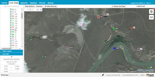
Integrated Tracking (iTrack) Solutions Loki Gen 6 is a web-based mapping software derived from a series of other Loki software products focused on asset tracking for large fleets of vehicles.
The maps are provided by Bing, but custom mapping can also be used with the support of Esri ArcGIS REST services and shapefiles.
iTrack Solutions is based in Calgary, Canada, and provides GPS tracking, mobile data communications and display software. The Loki Gen 6 features are listed below.
Home Home is a configurable dashboard showing plans, schedules, calendars and other details.
Live View Live View shows the live BING map from anywhere in the world, which includes maps, satellite and aerial imagery as well as maps provided by the user. Video streams are supported, and a 3D viewing feature is provided from Cesium. A user can add or draw features on the map to share with other users.
Photo: Integrated Tracking Solutions
Communication With this feature, users can communicate one-to-one or through a chat room, which includes video chat functionality.
Management An administrative user can assign tracking devices to vehicles, assign vehicles to subgroups, assign subgroups to larger groups or drivers to vehicles. An administrator also can set privileges for individual users.
Access to data Users can generate and view a replay on the fly as well as generate reports for vehicle tracking, hours in service, mileage, stop location and speed.
Observations, Analysis The forum feature provides a place group discussion, which becomes part of the Loki database, is searchable and can be linked to reports and replays.
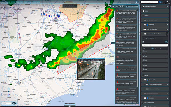
IDV Solutions’ Visual Command Center is a physical security and risk visualization (PSRV) software that unites data from external sources, enterprise systems and internal devices into a real-time, common operating picture of risk and security. Photo: IDV Solutions
IDV Solutions, a corporation that specializes in business intelligence, physical security and risk visualization software, has formed a technical partnership with Geofeedia, producer of a cloud-based social media monitoring platform. Through the partnership, Geofeedia’s location-based social media monitoring data will now be integrated into IDV Solutions’ Visual Command Center Enterprise Risk Visualization (ERV) software.
The companies say the combination of the two technologies enables security, supply chain and business continuity teams to gain instant intelligence from multiple social media networks for a myriad of risk events — from a political demonstration to a natural disaster. The location-based visualization filters out excess noise to show important social media posts in the context of locations of interest, such as facilities, employee locations, supply routes or traveling executives.
“Companies are looking for ways to efficiently gain actionable intelligence from social media,” said Ian Clemens, chief technology officer and co-founder of IDV Solutions. “The immediacy of social media combined with the alerting and locational context offered by Visual Command Center enables organizations to make more effective use of social media to protect employees, facilities and business continuity.”
The Visual Command Center provides a real-time, common operating picture of assets, personnel and operations in relation to potential threats to those assets. It unites information on global sources of risk — such as weather, terrorism and natural disasters — with data from internal data stores and physical security systems on an interactive map and timeline. When a risk is detected near an asset or employee location, the Visual Command Center automatically generates an alert and provides tools to assess whether the risk is a threat and take immediate action to mitigate the impact of the threat.
The Geofeedia integration complements the Visual Command Center’s Twitter Visualization and Alerting Module by providing information from more social media networks and visualizing all posts within a selected area.
Geofeedia enables organizations to filter and analyze social media content by location in real time across multiple sources. Users search for a city, address or location name, draw a virtual perimeter around the specific area of interest,and access geo-tagged social media content from within those boundaries.
“Location resolves the challenge of monitoring the massive amounts of cluttered data to identify meaningful, real-time on-the-ground intelligence when and where it matters most,” said Phil Harris, CEO and co-founder of Geofeedia. “We are thrilled to be able to help more organizations take advantage of our real-time, geotagged social media data to prevent, protect and respond to valuable intelligence.”
A decade’s progress: on the left, the 2004 AXTracker. On the right, the 2014 GTO.
Over a decade ago GPS World covered the introduction of the first battery-powered asset tracking device that operated over satellite networks, the AXTracker (“Going the Distance,” October 2003). More than ten years later, the technology has proven the market, and opened new markets. Battery powered tracking devices today are used for the expected, like enterprise asset tracking for trailers, containers, and field equipment, to the unexpected like tracking sea currents, ranging sheep, and weather balloons.
The newest products are dramatically smaller, have much longer battery life, and pack accelerometers and Bluetooth for mobile phone connectivity and wireless sensor interface. Yet power management, cellular and satellite communications, and environmental ruggedness remain the technical challenge.
Battery Technology. Advances have occurred in rechargeable technologies, largely driven by cellular telephones, military and automotive, but advances in primary batteries for industrial use are limited. Environmental operation is the problem. It remains extremely difficult to produce a primary cell that retains power for a decade while exposed to industrial temperature extremes. Global GPS tags for industrial use must operate in industrial temperature ranges of -40 C to + 85 C (-40 to + 185 F) while limiting self-discharge to enable operation over many years. Primary cells providing utility over the industrial temperature range with low self-discharge rates remain the same as available ten years ago.LiMnO2 (lithium/manganese dioxide) and Li-SOCl2 (lithium-thionyl chloride) are still the leading chemistries.
Lessons learned from field deployments have produced quality improvements and better field longevity and yield. Not all AA batteries with the same paper specifications survive equally, so developers must be wary. Through power reductions in satellite communications and GPS technology discussed below, the asset tag of today can enjoy a volumetric and cost reduction for batteries while achieving the same service duration.
GSatellite Network Technology
Ten years ago, the available global commercial satellite machine-to-machine (data) networks included Iridium, Orbcomm, INMARSAT and Globalstar. Though several of the satellite network service providers are replacing retired satellites, the technology remains unchanged and developers are left with the same choices today as ten years ago. Each satellite network offers different strengths and weaknesses for specific M2M field applications with different power budgets required. The AXTracker of a decade ago utilized the Globasltar simplex capability specifically because of the power budget profile for data delivery. From a satellite network power perspective, the limitations of one-way (field to cloud) satellite solutions employed by that first tracker continue to out-weigh other satellite network offerings.
In order to utilize the available satellite networks, the asset tag must integrate satellite communication circuitry. In a world of continuous technology improvements, the satellite transceiver evolution has been slow. Over the past decade most of the major satellite network providers have next-generation transceivers. However, the new technology has only marginally improved the power issues for battery-powered industrial GPS tags. For example, Iridium’s first OEM transceiver, the 9601, required peak power of 7.5W, with average power of 1.8W. Their latest transceiver, the 9603, is much smaller physically but still requires the same 7.5W peak, though average power is now 1W. Average power for an Iridium data packet delivery is the measure of the power used over message transmit and receive as well as idle times while accessing the satellite network. This average power for Iridium is the parameter used for calculating message delivery per a given battery capacity but peak power must also be supplied in any design that seeks to use the data service. Orbcomm and INMARSAT technology have similar power budgets due to their communications handshake requirements to access the network. For these systems, it remains difficult to source this power capacity and peak current requirements at -40C environmental temperature using batteries only.
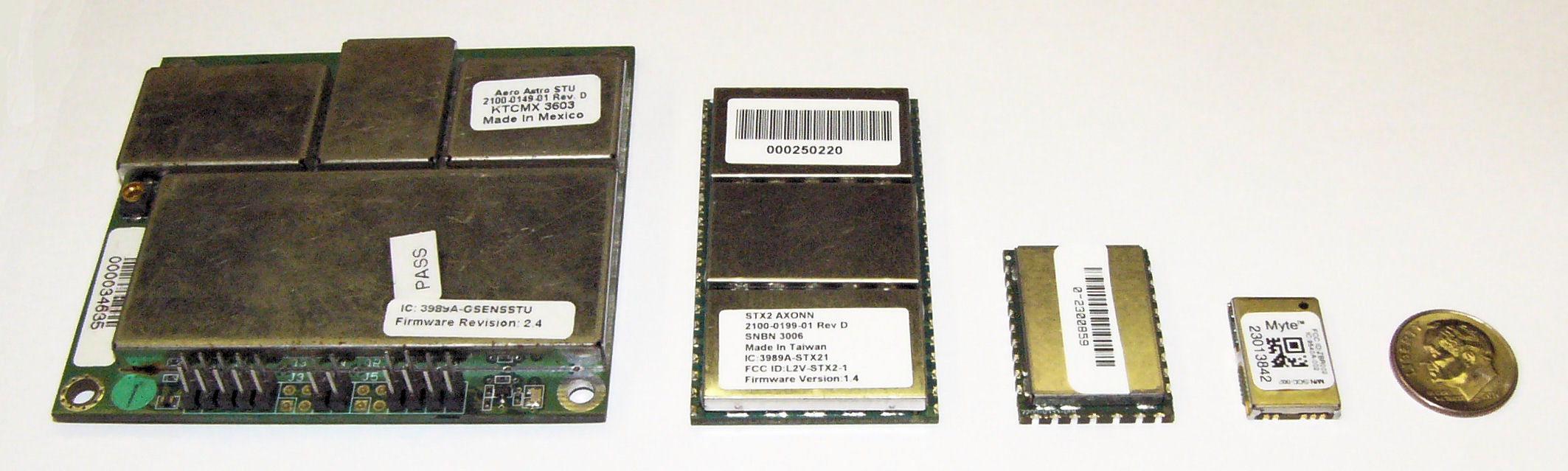
(From left) STX1, STX2. STX3, MYTE.
Similar power improvements are available in the Globalstar simplex system. The Globalstar system is different than the other commercial M2M satellite networks in that data is merely transmitted one-way from the GPS tag to the network, thus removing the power needs for handshaking with the network to deliver data. The STX1 radio transmitter of eleven years ago required a whopping 6W during transmit, but thankfully was soon replaced with the STX2 radio transmitter. The STX2 is still the primary simplex transmitter in use today and requires 1.65W during the one-way short-packet bursts. The much lower and short duration requirements for power were, and are, the deciding factor for network selection for the original battery operated GPS tag. Today, the Geoforce MYTE radio transmitter embedded in the GT1 and GT0 devices requires 1.1W peak, an 82% reduction from the short-lived STX1 and a 33% reduction from the STX2. For simplex service, the peak power is used to calculate message delivery per available battery capacity since there are no network access or receive power requirements. Ten years of simplex transmitter evolution and size reduction enable fundamentally smaller asset tags while providing a 30% to 40% reduction in power required for satellite data delivery.
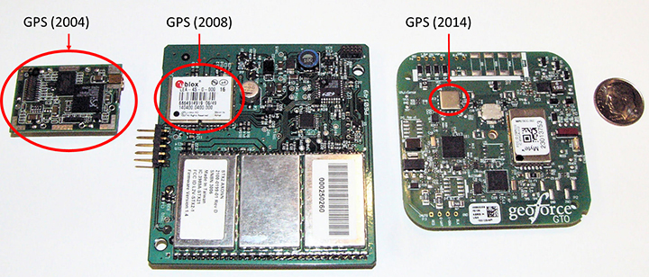
GPS Technology. Improvements here have made the greatest power budget impact for tag developers, greatly reducing the total power and current required to ascertain a location. GPS chipsets of ten years ago would kill today’s smartphones in hours. The newest GPS cores operate at much lower voltages and operating currents.The GPS engine of the first AXTracker operated at 3.3V and required 70 mA operating current for an average cold-fix time of 45 seconds (10.4 Wsec of battery power). Geoforce’s GT1 and GT0 embed the Origin Spider GPS module that incorporates the SiRFstarIV GPS chipset. This GPS engine operates at 1.8V with 37 mA operating current and an average cold-fix time of 35 seconds (2.3 Wsec). Even for challenging GPS field deployments, this represents a conservative 75 percent power reduction for location determination.
The power budget rule of thumb ten years ago was 20 percent went into idle sleep current, with the remaining 80 percent split roughly equally between satellite communications and GPS location determination. Improvements in satellite transmitter and GPS power technology have shifted the power budget ratio to 40 percent satellite communications and roughly equal power between idle sleep current and GPS location determination, for a net overall power reduction of roughly 33 percent.This means that the tag of today can last 50 percent longer than the tracker a decade ago with the same battery capacity. Alternatively, today’s tracker can have 33 to 50 percent fewer batteries to achieve the same service life depending on operational configuration.
GPS chipset evolution: from 2004 (left) to 2008 (center) to 2014 (right).
What about Cellular? Ten years ago cellular M2M systems were as much in their infancy as satellite systems. The advance of cellular telemetry tracking systems has exploded far faster than satellite systems for powered fleet-type assets, yet there are far fewer battery-powered cellular systems than satellite today. Two primary contributing technology factors impede the introduction of battery-powered cellular systems: network availability and network power requirements. Cellular tracking services have good availability as long as the asset operating area greatly overlaps consumer cellphone service.International and industrial applications have lower cellular regional overlap. As a result, battery powered cellular asset tracking devices remains a niche market.
Even if network coverage is acceptable, power budget asserts real technical problems for the developer.Cellular transceivers have similar power requirements as two-way satellite network, with high peak currents and relatively long network access dwell times. A multi-year, industrial temperature GPS asset tag operating over cellular is similar to a two-way satellite, requiring large capacity primary batteries, or rechargeable configurations that require frequent access to line power.For this reason, these battery-powered cellular asset tag technologies are seeing slower market insertion, leaving unpowered, industrial and international asset management applications to simplex satellite solutions.
Environmental Packaging
The largest product evolution observed in battery-powered asset tag technology is industrial packaging. Electronic and battery technology has remained fundamentally unchanged, however the packaging of these devices has changed significantly. Over the past ten years, the GPS asset tag has transitioned through many design and package iterations, all seeking to improve the reliability and service life of the industrial tag. Conflicting use-case requirements have contributed to field failures. Customers often demand features similar to commercial electronics systems such as rechargeable or replaceable batteries, or connectivity of remote sensors. While these features are highly desirable, they also lead to field failures in rugged, industrial environments. Chief among environmental failures is water intrusion.
Customer expectations for wired sensor connectivity or battery replacement require connectors for wiring or panels to access the battery compartment with gaskets to prevent water intrusion. The stressors of industrial, multi-year fielded devices are unlike consumer electronics systems. Industrial tags are subjected to directed pressure washing, often at forces sufficient to cut plastic. And unlike commercial electronic systems, the industrial tags see the full temperature range of automotive-grade electronics while still providing compartments for battery replacement (something that most automotive electronics products do not require). Beyond liquid water intrusion, many products succumb to water vapor intrusion that subsequently condenses inside the device due to large temperature swings. Gaskets designed to prevent water are less able to prevent passage of small amounts of atmospheric vapor due to a vacuum created on temperature drop. The effect is easy to visualize if we apply the ideal gas law, PV = nRT where P is pressure, V is volume and T is temperature (n and R are constants). For a given volume inside the tag, the pressure changes proportionally with temperature, thus a tag that experiences a drop in temperature will also experience a drop in relative pressure and will pull in minute amounts of water vapor, which over time will condense and cause product failure.
Several obvious solutions exist, starting with removal of internal air volume through encapsulation (potting). Encapsulation seeks to take V to zero, thus making the device impervious to vapor intrusion caused by temperature swings. Additionally gaskets can be removed at the tradeoff of inaccessible batteries.
Putting It All Together
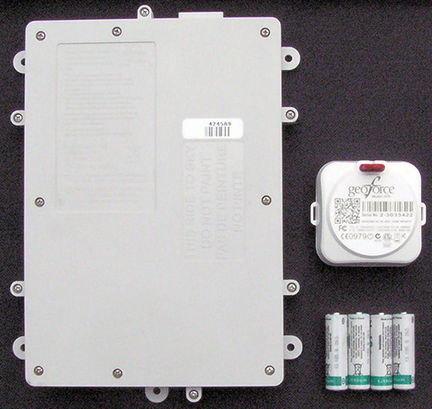
The Geoforce GT0 leverages over a decade of lessons learned. It incorporates the smallest, lowest power simplex transmitter, salvaging 33% of power required for satellite communications. It also uses the Origin Spider GPS module, which includes the latest SiRFstarIV GPS chipsets, harvesting 50% of the power for location fixes. The GT0 also incorporates the latest circular polarized antenna technology from Tallysman, with unparalleled performance compared to previously available commercial patch antennas.
The combined antenna design and power savings enable the GT0 to require only half of the batteries with an 85% reduction of device volume to achieve the same or better field service life compared with the tracker of ten years ago. The lower volume alone reduces the risk for water intrusion, but the risk is further reduced by the use of encapsulation and non-replaceable batteries. The GT0 is therefore fully sealed, disposable and encapsulated. This packaging concept makes the GT0 extremely rugged and impervious to directed water or water vapor intrusion. Thus, the GT0 is truly in a class of its own. The technology advancements and lessons learned over the past decade have enabled mechanical footprint and volumetric reduction of the global, battery-powered GPS asset tag.
The GT0 combines the smallest, lowest power satellite and GPS engines with innovative packaging to create the smallest, industrial-grade global satellite asset management tag available anywhere, setting the bar for size, value and performance.
Asset managers today need more than dots on a map. They need asset utilization metrics that provide actionable information for improving operations. Knowing where an asset is and where it is moving is sometimes enough, and for these applications GPS enabled, battery-powered tags provide supreme value.New tags provide the value of track and trace, but also can relay data from nearby sensors using short-range Bluetooth wireless interfaces.This capability will evolve the utility of yesterday’s global tag, closing the gap from location only toward satellite-based telematics, but that is a story for another day.
Gary Naden serves as Chief Technology Officer at Geoforce, manufacturer of satellite telemetry asset tags for oilfield and hazardous environment use.
KCS BV has launched a new tiny tracker, the TM-202LAR. It’s the newest addition to the KCS family of TraceME products. The KCS GPRS/GPS range of modules enable users to remotely track and trace people, animals and a variety of objects, such as vehicles, containers, motorcycles, lawn mowers, or other valuable assets.
KCS TraceME TM-202LAR is targeted for personal use, or any other application that needs a small size with long battery life while still featuring the options and server connection that full-size units have.
The TraceME TM-202LAR is KCS’s smallest full featured GPS tracker at 46 x 21 x 6.5 mm, weighing 7 grams. Other features and options include:
GPS, RF and GSM antennas
advanced power saving, down to 2.5µA
10 years of operation from one Lithium C-Cell
RF connectivity, up to 2 km
location-based positioning (LBS/Wi-fi/GPS)
onboard sensors for compass, temperature, acceleration

 The TM-178/R9H7 module has been upgraded with optional LoRa, Wi-Fi, Bluetooth Smart (BLE), ANT/ANT+ and proprietary RF, which enables easy integration with existing wireless networks and specific custom mobile apps on smartphones and tablets.