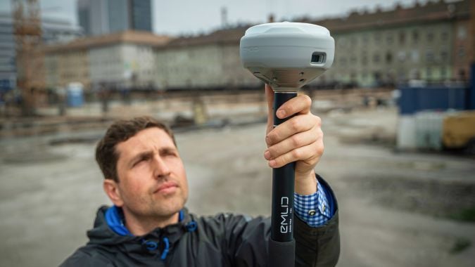
Emlid has introduced a new generation of all-band RTK receivers including the Reach RX2, Reach RS4 and Reach RS4 Pro. They are built for surveyors, GIS specialists and construction teams seeking reliable, high-accuracy positioning with consumer-level ease of use. This EU-based developer of high-precision GNSS receivers and software is on a mission to make professional-grade precision simple, fast and scalable.
The Reach RS4 and RS4 Pro mark a significant step forward from previous Emlid models, combining rugged engineering with faster workflows and uncompromised accuracy. The flagship Reach RS4 Pro introduces innovative camera-vision technology that blends traditional RTK with visual positioning to cut survey time and simplify work in complex environments.
Image: Emlid
Both receivers support all-band RTK reception (L1/L2/L5/L6) across every major satellite constellation, ensuring consistent performance even under canopy or in urban canyons. An integrated antenna system with diversity LTE, dual-band Wi-Fi and Bluetooth provides a clean GNSS signal and stable fix, while the Emlid multi-band radio system — up to 2W and interoperable with third-party gear — offers flexible correction transmission at 450MHz and 915MHz for both licensed and licence-free use.
Further enhancements include next-generation IMU tilt compensation that initializes up to five times faster than before, a durable magnesium alloy body with IP68 protection, and Made for iPhone certification enabling smooth integration with iOS applications such as Esri ArcGIS. A new quick-release survey pole mount ensures fast and accurate setups, even when tilted.
AR-based stakeout and measurement from images. Building on the RS4 platform, the RS4 Pro adds dual factory-calibrated full-HD cameras that enable augmented reality (AR) stakeout and measurement from images. The AR interface projects geometries directly in the Emlid Flow app, guiding users intuitively to stakeout points. The image-based measurement feature allows for accurate coordinate capture from photos, which is ideal for hard-to-reach places such as facades or active roadways. Together, these vision-based tools streamline fieldwork and reduce reliance on total stations in difficult conditions.
For users prioritizing mobility, the Reach RX2 delivers professional RTK performance in a compact, plug-and-play format. Like its larger counterparts, it supports all-band RTK signals and features a second-generation IMU tilt compensation system for level-free measurements. A new quick-release mount enables rapid setup in the field.
Designed for GIS, construction and asset management teams managing multiple projects, the Reach RX2 integrates seamlessly with Esri ArcGIS for data collection and Pix4Dcatch for mobile terrestrial scanning.
Complete field-to-office workflow. Emlid’s product ecosystem — including the Emlid Flow mobile app and Emlid Flow 360 cloud platform — creates a complete field-to-office workflow for professionals who value simplicity without sacrificing precision. The system enables companies to assign surveying tasks to non-surveyor teams, reducing training requirements while maintaining professional accuracy standards.
The Open Geospatial Consortium (OGC) has formed the Geo for Metaverse Domain Working Group (DWG), which will serve as a forum for the collective geospatial expertise of the OGC community to gather to help build and expand the open Metaverse. The group is open to both OGC members and non-members.
The group plans to contribute its expertise in 3D, modeling and simulation, artificial intelligence, digital twins, streaming, augmented and virtual realities, routing, mapping and more — all at scale.
The group will work on pieces of the Metaverse that pertain to geospatial applications and standards by identifying standardization activities and best practices based on FAIR (making data Findable, Accessible, Interoperable and Reusable) data principles.
The DWG will be the primary point of contact with the Metaverse Standards Forum, of which OGC is a founding and principal member.
3D geospatially anchored data is powering innovation across a range of industries. This same data — relied upon for construction of the real world — is now driving the creation of virtual/digital worlds that will form parts of the Metaverse.
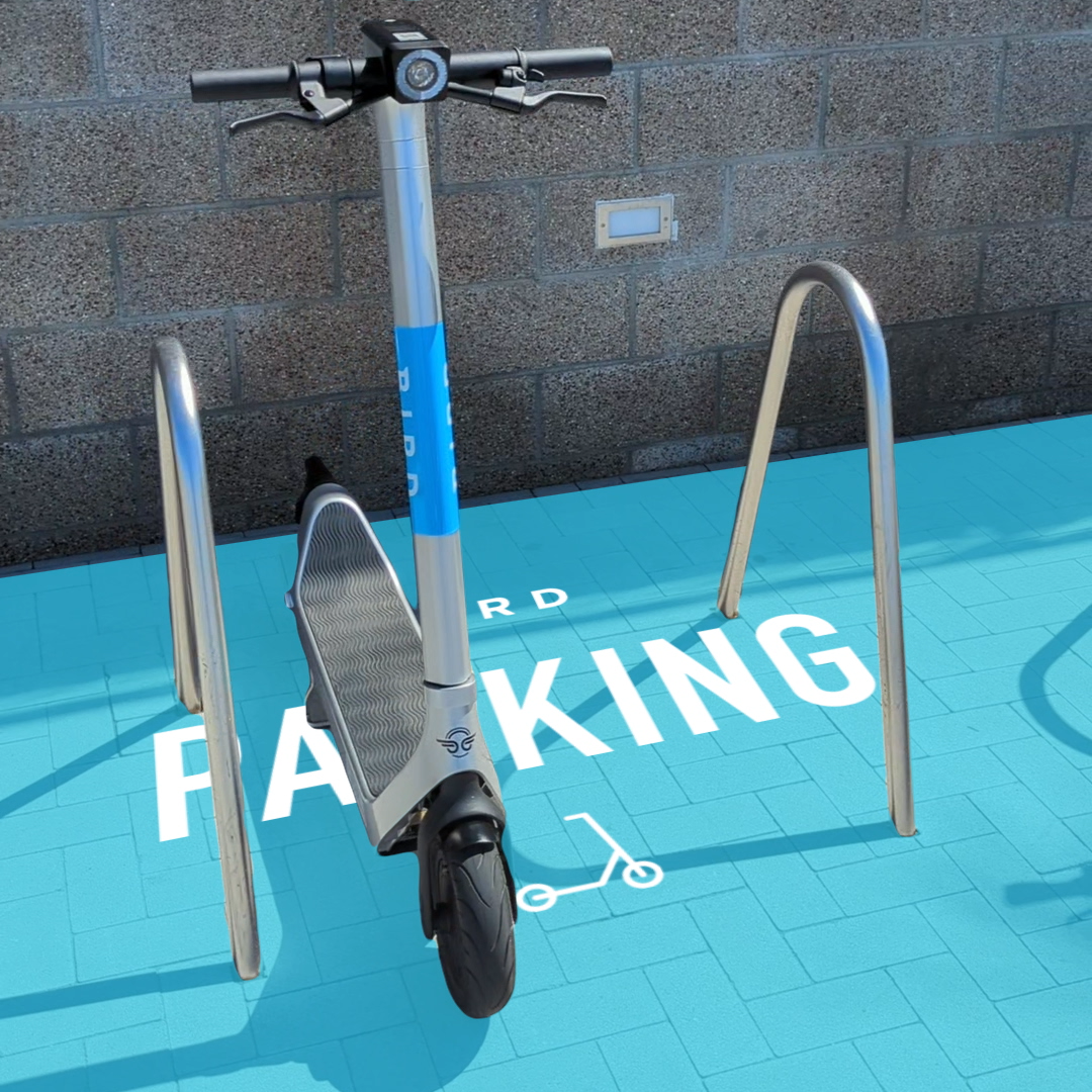
Bird uses the ARCore Geospatial API to enable a scooter parking app. (Image: Bird)
Google has launched the ARCore Geospatial API in ARCore software development kits (SDKs) for Android and iOS across all compatible ARCore-enabled devices.
The application programming interface (API) is available at no cost to download and opens up nearly 15 years of Google Maps data to help developers build more useful and immersive augmented reality (AR) experiences.
“The Geospatial API provides access to global localization — the same technology that has been powering Live View in Google Maps since 2019, providing people with helpful AR-powered arrows and turn-by-turn directions,” explains a Google blog.
“Based on the Visual Positioning Service (VPS) with tens of billions of images in Street View, developers can now anchor content by latitude, longitude and altitude in more than 87 countries, without being there or having to scan the physical space, saving significant time and resources.
“For end users, discovering and interacting with AR is faster and more accurate as images from the scanned environment are instantaneously matched against our model of the world,” the blog states. “This model is built using advanced machine-learning techniques, which extract trillions of 3D points from Street View images that are then used to compute a device’s position and orientation in less than a second.
“In other words, users can be anywhere Street View is available, and just by pointing their camera, their device understands exactly where it is, which way it is pointed and where the AR content should appear, almost immediately.”
Early-access partners include the NBA, Snap and Lyft, who are exploring and building applications in areas such as education, entertainment and utilities. For example, micromobility companies Bird, Lime and WeMo are using the API to remove friction from parking e-scooters and e-bikes, adding pinpoint accuracy so that riders know exactly when their vehicle is in a valid parking spot. Lime has been piloting its app in London, Paris, Tel Aviv, Bordeaux, Madrid and San Diego.
View from a weather balloon at 100,000 feet. (Photo: NOAA)
“We’re at 103,000 feet. As you look up the sky looks beautiful but hostile. …Can see for over 400 miles. The sky [above me] is absolutely black. …I can see the beautiful …deep, dark, indescribable blue [sky below], which no artist can ever duplicate. It’s fantastic.”
— Capt. Joseph W Kittinger, USAF, Operation Excelsior III, August 16, 1960
This month, our journey begins in the future. Imagine you are in Alamogordo, New Mexico, a town with a rich history in America’s space program. You are here for a proof-of-concept, real-world exercise. After two years spent training, you are on a team that will test the viability of a stratospheric airframe, or high-altitude platform station (HAPS).
The exercise is a joint venture between several large corporations and U.S. government agencies. The HAPS began as a telecommunications support platform, but now includes many different industries. It will test backup systems for GPS and other sensing technologies.
Remote sensing is an obvious use case, and sensors are onboard to collect hyperspectral and thermal images, synthetic aperture radar, lidar, magnetometry, weather and other types of data. Some equipment is mounted on top of the platform to point toward space to monitor satellites and orbital debris. Also aboard are are satellite relays and space-based communications systems. Additionally, a Hubble-like observatory will support NASA research.
On the ground at the command center, other teams are working on the project. A mapping and survey team is in the field to ground truth the precision, accuracy and resolution of the HAPS data.
Autonomous vehicle manufacturers are testing telemetry data from the HAPS for improved precision navigation. Teams of imagery analysts and geospatial analysts are assessing the quality and value of the products, including full-motion video live-streamed from the HAPS.
Aerospace engineers are studying the performance of the airframe and monitoring its structural integrity. Meteorologists are providing upper air wind and weather forecasts. Several teams of engineers are managing various robotics systems onboard, and more scientists and engineers from multiple companies and agencies are testing their equipment.
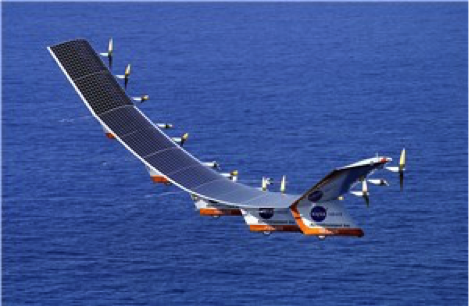
The solar-powered Helios in flight. (Photo: NASA/Aerovironment)
Your Mission as a Stratonaut
Most tests and modifications are being handled remotely, but some require replacing the systems. This can only be accomplished by physically going to the sub-orbital station. Imagine this is your job.
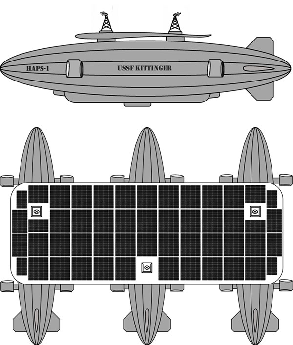
You are a remote sensing technician specially designated as a stratonaut. Your training familiarized you with the various systems onboard. You trained how to use your pressure suit — its dangers, risks and capabilities — and how to interface with the suit’s augmented reality system. You know how the HAPS operates, its schematics, and the interiors of the three connected dirigibles. You can navigate your way around the HAPS and access the various decks and compartments as well as the sensors, equipment, charging ports, fuel cells and motors. You can fly the drones, dock with the station, and enter its hangar bays. You can do maintenance on the autonomous robots and the remote-controlled robots onboard the station. You know the security and safety protocols. All this you know and more; and, if things go wrong, you know what to do.
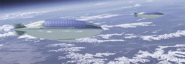
Vision of the Alpha, Bravo and Charlie HAPS stations. (Image: William Tewelow)
On this mission day, it’s early morning. Sunlight is beginning to pierce the sky above the Alamogordo base station. Two technicians are helping you into your pressure suit. Another technician at a desk has your helmet hooked up to the computer. The LED lights encircling the facemask blink slowly, indicating data is being uploaded. The augmented reality face shield glows a soft blue as the data flashes across it.
Overnight at the command center, operators controlled descent of the HAPS from 100,000 feet. It takes 10 hours to reach 65,000 feet, the altitude for your rendezvous with the station. You will fly up to the HAPS in a cargo delivery drone and dock at the forward hangar bay of Station Bravo (the second dirigible). You’ll be installing an enhanced high-resolution hyperspectral sensor array in the station’s lower observation deck.
While you are busy with the installation, the autonomous robot onboard will be in the hangar bay, swapping out the station’s spent fuel cells with fresh ones carried up by the cargo drone. Each weighs 250-pounds. After this task, the cargo drone will fly to Stations Alpha and Charlie and swap out their spent fuel cells.
Once all three are completed, the cargo drone will return to Station Bravo and take you to the top of Station Charlie to install a satellite laser relay (SLR) communications system. A remote-controlled robot operated by the engineering team at base command will meet you and carry the SLR up to the tower. While you are installing the SLR, the cargo drone will dock and recharge for your return trip. The entire mission will take seven-hours and 45 minutes.
“Many functions currently done with satellites could be performed for tactical and operational commanders using near-space assets, much more cheaply and with much greater operational utility. By operationally grouping near-space with space, the functional expertise synergies would allow much more efficient delivery of space effects to the joint commander.”
— Lt. Col. Edward B. Tomme, Ph.D., USAF, Air Power Research Institute
Two Types of Pseudolites
High-altitude, long-endurance (HALE) airframes — also referred to as pseudo-satellites, pseudolites and stratolites — are of two types.
Heavier than air. The heavier-than-air (HTA) type is a lightweight, fixed-wing aircraft with extremely long wingspans. It can stay aloft for a month or more.
HTAs are limited to carrying small payloads. They typically rise to 100,000 feet during the day powered by their solar cells, and at night descend to 60,000 feet, repeating this cycle until the batteries need replacing. The HTA platform is good for short-term missions over a broad area of interest because it normally flies in large circular patterns.
Lighter than air. The other type of pseudo-satellite is a lighter-than-air (LTA) airframe. The typical example is a dirigible, but these platforms can take on many shapes and sizes. LTAs can be enormous, with lifting capacities upward of 100,000 pounds. They operate as geostationary platforms loitering indefinitely over an area of interest and remain at the same altitude day and night. An LTA can last for 10 years or more.
The best solution is a combination of the two. A large LTA can serve as a base station to support several small HTA platforms.
“Together, NASA and the Space Force seek to advance, protect and sustain activities in, from and to space. This is truly a new era of strategic collaboration that will benefit commercial, civil and national security in space.”
— John W. Raymond, General, Chief of Space Operations, United States Space Force
A stratosphere-based telecommunications platform proposed by the Elefante Group. (Image: FCC)
HAPS Alliance
Furthering the development of the pseudo-satellite industry is a consortium of 49 companies and universities called the HAPS Alliance, which advocates for investment in this area.
The stratosphere has become increasingly important for commercial interests and national security. HAPS can provide the best of what manned aircraft operating at lower altitudes can offer, combined with the benefits of satellites, minus much of the downside of each.
Limits of aircraft. Aircraft operating at lower altitudes offer high resolutions and targeted collection. They can be easily retasked and rerouted, and equipment can be easily repaired or replaced. Aircraft are limited by constraints of time, fuel, weight, distance and weather.
Limits of satellites. Satellites, on the other hand, provide broad area coverage and long-term, operational endurance, but they are 240 miles or more above the Earth traveling at 17,500 miles per hour, or they are 18,000 miles above the Earth to maintain a geostationary orbit. It is a trade-off between resolution and dwell time.
Other drawbacks of satellites are their expense. Launching is costly and recovery is nearly impossible to make repairs. Doing so is impractical.
HAPS do not have those limitations. They can provide long-term, persistent operations over an area of interest at very high resolutions. They also can carry a complete package of sensors and equipment with the additional benefit that most everything can be repaired or replaced with minimal cost.
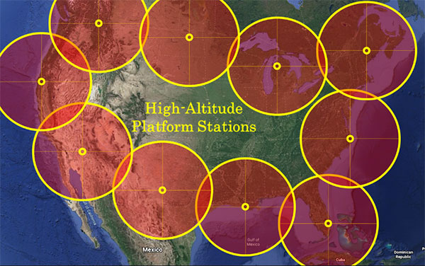
Locations of HAPS to cover the borders of the Continental United States. (Image: William Tewelow)
How HAPS Will Improve Geospatial Data
These systems are going to improve geospatial information. HAPS will improve spectral resolutions by a factor of 10x or better. The improved location accuracy data will impact navigation, surveying, construction, emergency services, logistics, transportation, aviation, agriculture and most other industries.
The HAPS will act in tandem with cellular networks on the ground to improve internet connectivity and telecommunications. They will improve national security while monitoring the effects of climate change, deforestation, urban sprawl, ozone, pollution and natural disasters such as floods, forest fires, tornadoes, hurricanes and more.
Provided testing proves HAPS a success, the pseudosatellite era is going to greatly impact most everyone’s life. If you are lucky, you might actually become a stratonaut. If you are interested, now is the time to prepare.
“This point of observation commands an area nearly 50 miles in diameter. The city, with its girdle of encampments, presents a superb scene. I have pleasure in sending you this first dispatch ever telegraphed from an aerial station.”
— Thaddeus S. C. Lowe, First Chief Aeronaut, Union Army Balloon Corps, Civil War, 1861
William Tewelow
William Tewelow is a Senior Aeronautical Information Specialist for the Federal Aviation Administration. He is a designated Geographic Information Systems Professionals (GISP). He served on special assignment to the U.S. Department of Transportation and led a national strategic geospatial initiative under the authority of the White House Open Data Partnership. He was among the first in the nation to earn a Geospatial Specialist Certification from the U.S. Department of Labor while working at NASA Stennis Space Center.
He is a 2016 graduate of the FAA’s management fellowship Program for Emerging Leaders. He has degrees in Geographic Information Technology and Intelligence Studies and is earning a master’s degree in Organizational Leadership with a focus on Performance Management. He is a mentor with the FAA’s National Mentor Program.
Tewelow retired from the U.S. Navy after serving 23 years as a Geospatial and Imagery Intelligence Specialist, a Naval Aviator, a Meteorologist, and a Tactical Oceanographer earning three achievement medals. He is married, enjoys traveling, connecting people, solving problems, and interested in new technology. His favorite quote is, “A man’s mind changed by a new idea can never go back to its original dimension.” ~ Oliver Wendell Holmes
Orbit Logic’s SpyMeSat mobile app (available via the Apple App Store and Google Play) now includes an augmented reality (AR) interface for better awareness of overflying imaging satellites. The AR view overlays the orbit and position of satellites that can image your location, providing a better understanding of satellite viewing geometry and potential obstructions. For example, it makes it possible to know if an image taken by that satellite of your position would be obscured by a tree or a building. The AR interface also displays relevant information about the satellite and its capabilities, including the timing and dynamic geometry of the pass as well as the resolution achievable by satellite sensors.
In addition to real-time imaging satellite awareness, SpyMeSat provides on-demand access to recent archive satellite imagery and the ability to request new tasking directly from a mobile device. Multi-phenomenology data (optical, infrared, synthetic aperture radar, and more) is available through an in-app process of preview, select, payment, and delivery that can be completed in seconds, providing archived satellite imagery for any location on demand. When archive imagery is insufficient and new data is required, users can review available satellites, better understand the data collection environment through the AR interface, and purchase tasking based on cost, responsiveness, and capability.
While the standard SpyMeSat enables marketplace interactions between the public and commercial satellite imagery providers, Orbit Logic also develops custom mobile applications for better situational awareness and easier data-access/tasking supporting specific missions. The new AR interface will enhance these users’ mission effectiveness by facilitating better understanding of how data collection might be impacted by surrounding terrain or other spatial factors. Examples of bespoke SpyMeSat deployments include government versions for government assets and versions for awareness of satellite communications opportunities for contact scheduling, data transfer, and command uplink.
Orbit Logic specializes in mission planning and scheduling solutions for aerospace and geospatial intelligence. Its COTS products create better plans faster with fewer resources for all mission phases. Orbit Logic services are available to configure, customize, and integrate its mobile, web-based, desktop, and flight software applications to provide turn-key operational solutions that leverage the latest available technologies to meet customer goals and exceed their expectations.
The surveying profession has experienced a plethora of advancing technology over the past two decades and it does not look like there will be a slowdown any time soon. From robotic total stations to laser scanning to the use of multiple GNSS constellations, the profession is constantly adapting these emerging technologies into a useful tool for daily applications. For most practicing surveyors, it is a challenge to keep up with not just the hardware of these advancements, but also with software, which is being developed in parallel. Have you tried to open and draw a simple figure in any of the industry standard CAD programs lately?
The complexity of these programs, while advancing the capability of many technical professions, forces even the casual user to maintain a regular habit of software education and training. While it may seem primitive to say that a practitioner is a “practicing” surveyor, on-the-job training never stops. Just when the profession thinks there are no more significant advancements, something comes out of left field that truly blindsides us. (See the adoption of UAVS by the surveying profession compared to the public sector…) What do I think will be one of the next “big things” to revolutionize surveying? The technology is already here, and we need to seriously get on board with adoption before we miss another opportunity to highlight the expertise of the profession.
VIRTUAL REALITY and AUGMENTED REALITY (VR & AR)
First, we need to know that virtual reality (VR) and augmented reality (AR) are different, even though many people use these terms interchangeably. The differences are as follows:
Virtual Reality (VR)
VR is a virtual world generated by computers and programming.
VR is a closed environment that is fully immersive.
VR requires a device (specialized glasses and/or a headset).
Users in the VR experience are limited by the programming and their computer’s abilities.
The VR experience may be based upon real-world conditions but is a fictional setting.
Users of VR can travel and experience conditions in real and fictitious places.
VR can allow users to have experiences that are not physically possible in the real world.
VR is 75% virtual + 25% real (industry “rule of thumb”)
Augmented Reality (AR)
AR is typically based on actual physical places.
AR is an open environment that is partly immersive.
In AR, the user controls the environment.
AR combines virtual elements and experiences with real world conditions.
Experiences in AR can be accessed by computer, tablet, and smartphones.
AR is useful for product visualization and evaluation.
AR is 75% real + 25% virtual (industry “rule of thumb”)
It is important to know these difference between the two technologies in order to implement the correct one for the task at hand. However, both will play an important in surveying for generations to come.
One of the surveyor’s biggest responsibilities is to complete an accurate site conditions model by topographic methods. Once the topographic survey is completed, site designers will utilize this information to create a unique project that works with the existing site conditions. Advances in CAD software and technology allow engineers and architects to design in 3D and blend the new site with the existing conditions, drainage, and utilities. These designs can be further refined into virtual reality models to give the project’s stakeholders a better indication of what the final product will be when construction is completed.
The key takeaway here is that the surveyor is responsible for delivering the existing conditions model. A model that accurately represents the subject site but in digital form enables the design of the project to be more efficient and realistic to meet the client’s expectation. Surveyers, however, will not use virtual reality as much as augmented reality, for many good reasons.
USES OF AUGMENTED REALITY TECHNOLOGY FOR SURVEYING
AR is still in its infancy. Because surveyors have an interest in the existing and proposed conditions of sites, the use of AR becomes an important tool for the future. Merging proposed information with existing site conditions can become the norm, but like many emerging technologies, the profession will need to learn how to embrace it.
To get a better idea of how the technology works and why surveyors need to consider using it, let us look at an application that showcases AR: Pokémon Go. Yes, the smartphone game app that took the world by storm in 2016 and captivated many “trainers” to search the streets for Ultra Balls and characters. (There are still more than 100 million active players worldwide.) Players of all ages have continued to search for elusive items and characters in a high-tech scavenger hunt that is constantly changing, and all based upon the real world around us. By merging a real-time view with game entities at random geographic locations, players move about our world using one of the best examples of AR.
How does this apply to the surveying profession? Surveyors could utilize AR in everyday tasks but that would require having a fully developed 3D design model that could merge with the existing conditions in their visual device. There are a variety of devices for utilizing AR, including smartphones and tablets. Many of the new data collectors running Windows and Android operating systems can also be used for incorporating AR into the field operation. Here are some examples of AR how can be utilized for surveying tasks:
While construction staking, AR can be used to assist with structure and improvement location. A quick visual check can help confirm staking calculations are consistent with engineering design.
Use AR to visually check installed improvements, including curbs, utility structures, and paving. Any deviation from the proposed design should be quite evident.
When establishing property corners, AR will help the field crew quickly determine whether the calculated location is accessible. This can be used for staking out pre-calculated boundary points and/or proposed lot corners in a new subdivision.
Here are a few ideas as to how surveyors could utilize AR in everyday tasks in the future:
As public utilities are becoming more available within GIS shape files with geographic locations, they could be utilized with AR to help visually establish locations in the field. Mainline utilities and service lines would become easier to physically verify using AR.
Another GIS shapefile entity, the parcel line layer, could be used to help the surveyor understand where the property owner believes the line(s) to be as opposed to the actual monumented location.
All reference monuments and benchmarks established by public agencies using geographic location information could enhance the “treasure hunt” of confirming local datum points.
SURVEYING USING AR TO PROTECT THE PUBLIC
Geospatial information has revolutionized our world, so using AR to help when trouble strikes can potentially be a lifesaver. Recently, an oceanfront condominium in Florida collapsed due to structural failure. While the age of the structure precluded it from having any digital geographic location data, any new similar development could be measured and recorded to assist with future emergency needs. Almost all new development has digital surveying, engineering, and architecture and must use local horizontal and vertical datums. Using the proposed information and verifying with post-construction record drawings, the digital record can be created.
It doesn’t take a design flaw to create a public hazard. For instance, a gas leak could render any building, such as the Florida condo, susceptible to catastrophic damage. By having a digital model of the underground structure, emergency crews could use AR to help locate potential open spaces in the building. As is the case with installing fire suppression systems and emergency exits, the cost to create a digital model of a completed building will be well worth it to save lives.
Underground utility corridors within cities, campuses, or manufacturing facilities could also utilize geospatial locations to establish a digital map for future use with AR. It will take time and significant cost to map existing facilities, yet it should be required for new sites to provide this information for emergencies and for use when designing expansions within the site. Having this utility information to use with AR during the design phase could lead to identifying potential problems before construction starts.
Haiti after an earthquake. (Photo: 1001nights/E+/Getty Images)
Another reason to plan for future safety is how much uncertainty we face in today’s society. At press time, we are coming up on the 20th anniversary of 9/11. We also just watched Haiti suffer another devastating earthquake. The 2021 hurricane season has also been very active, so that danger looms large, too. Disasters happen all the time with little to no warning. Our world is much more advanced than we were at the turn of the century, so we can use these advancements to map our infrastructure. Let us hope we never need to use the digital information for another disaster akin of 9/11. Instead, let us use it to ensure that we can get to someone in a remote spot if necessary.
THE ROAD TO FUTURE MAPPING AND AUTOMATION
As previously discussed, establishing a digital twin of our world could help provide a better map for establishing parcel ownership, reducing construction conflicts, and offering better planning tools for future expansion. Will it be completed within my lifetime? No, and I doubt it will be done within the next couple of generations after me.
We can, however, get a significant start on capturing the necessary information to begin the process of digitization. Technology has exceeded my expectations just within the past decade, so I can only hope that more advancements will help with building this digital beast. More architects and engineers are utilizing BIM (building information modeling) for 3D design and collaboration. Most municipalities and counties have built some form of GIS that uses one of the standard geographic datums. Surveyors have fully embraced GNSS technology so state plane and national geographic coordinate systems have become the norm. In addition, we are seeing a wide number of consultants use autonomous vehicles (aerial, hydro, and terrestrial) with photogrammetry, LiDAR, and SLAM remote sensing. Another bit of good news is that computing power is higher than ever and that storage space is cheap for all this data. We should also include how 5G has expanded our reach and, with cloud storage, we can work from just about anywhere. We can do so much more than most of us ever dreamed of, so we need to leverage that into creating a digital entity that can be helpful.
Photo: RyanJLane/E+/Getty Images
HOW TO IMPLEMENT THE LATEST TECHNOLOGY
Augmented reality is one of many new technologies surveyors need to introduce into their toolbox. Many of you may be asking where to begin; my answer, depending on your age, may offend you.
Hire a Gen Zer. Really.
As a Gen Xer, I have come to realize my limitations on technology and being able to fully implement it. The Z generation, while lacking the experience of us wily old guys, see things much differently. The smartphone/tablet/computer, and even the latest data collectors, are designed with them in mind. They grew up playing computer games based in virtual reality, developed excellent hand-eye coordination, and find efficient ways of getting things done. Our surveying world is almost completely digital (when is the last time a client only wanted paper copies of a plat?), so now is the time to make the leap and ditch the drafting table. We have as much to learn from them as they do from us. Together, we can get the surveying profession ready for the next generations. It has been a great profession for us, so let us hand it off to the Z generation. They will (eventually) be glad we did.
Hexagon AB has acquired Immersal Oy, an innovator of spatial mapping and visual positioning solutions for producing augmented reality (AR) applications.
AR applications enhance real-world experiences by augmenting a user’s visual perception with the display of digital content in the physical world.
AR’s ability to weave context-specific, 3D information into physical spaces provides endless opportunities to save time, improve performance and reduce costs across a wide range of industries and applications — from surveying, construction, public safety and manufacturing to maintenance, training and navigation applications.
An immersive experience can help boost task efficiency, improve safety protocols, optimize workflows and increase collaboration.
The Immersal SDK (software development kit) allows developers to merge and “anchor” digital content to real-world objects – with precise accuracy to their actual location in the physical space — by enabling a user’s mobile device to locate and orient itself in the surrounding physical world using machine-readable maps.
The maps, which are used for visual positioning, are constructed from image data supported by various mapping devices (including mobile phones) and hosted in the Immersal Cloud Service.
“Hexagon has long been a leader in delivering smart digital realities that combine inputs from reality capture sensors with advanced visualisation software and tools to enable remote, location-based intelligence. This acquisition puts the power of these insights into the hands of those on-site, enhancing their field of view with superimposed digital information, meaning they can literally do more with what they see,” said Hexagon President and CEO Ola Rollén. “For example, direct access to information about an asset — while working with that asset — including step-by-step instructions on how to repair it, can streamline maintenance tasks while reducing material waste and re-work.”
Immersal has years of experience developing AI and machine learning-based spatial anchor technology, which “anchors” virtual objects or models for viewing on different devices in the same position and orientation. This unlocks a wide variety of location-based solutions and services — from consumer-oriented augmented reality applications in gaming and media and entertainment to digital twin solutions on an enterprise scale.
Immersal’s technology can map large spaces — both indoors and outdoors — and works both offline on-device and online using the Cloud Service.
Founded in 2015 and headquartered in Helsinki, Finland, Immersal will operate as part of Hexagon’s Geosystems division. The acquisition has no significant impact on Hexagon’s earnings.
Drone company Parrot is partnering with Rapid Imaging, a technology provider delivering geospatial augmented reality (AR) and situational awareness solutions to government and enterprise users.
The partnership pairs Parrot ANAFI USA platform drones and the FreeFly SDK with Rapid Imaging’s SmartCam3D SDK, a geospatial augmented reality and situational awareness platform for unmanned aircraft systems.
SmartCam3D overlays geospatial data such as street vectors, road names, points of interest, polygons and other pertinent map entities onto real-time, full-motion video (FMV) provided by ANAFI USA’s 4K HDR video, 32x zoom and live video streaming capabilities. This provides mission personnel with advanced situational awareness as they perform critical drone operations.
SmartCam3D also allows end-users to interact with live drone video in the same ways they would a map display, such as dropping a pin to mark a location or geocoding a selection from the real-time video stream.
These situational awareness capabilities provide opportunities across a variety of mission sets: airborne law enforcement, insurance, industrial inspections, natural disaster response, real estate and search-and-rescue operations.
The SmartCam3D SDK is a turn-key solution for UAS platform providers seeking to enrich their offerings with geospatial augmented reality and situational awareness tools. Features include geospatial AR, allowing users to enjoy a “Google Maps” type experience but with live drone video as the background layer rather than a satellite image. Granular declutter options allow users to select the types of map entities displayed on their live video feed.
Custom GIS data integration allows users to import their own geospatial data to display. Pin-dropping allows users to mark locations within the live video with AR annotations and communicate those locations to a map display.
Also, forward- and reverse-geocoding allow professional drone pilots to designate a point in the video and immediately receive the geospatial data associated with that point (lat/long or address) or designate a location and mark the location with an AR annotation within the video display.
Finally, cross-Cuing allowing end-users to simultaneously navigate a full-motion-video display and map display.
“Leveraging Parrot ANAFI USA’s precise GPS coordinates and advanced flight features, SmartCam3D® provides first responders and military personnel with up-to-date geospatial AR overlays on live video, combining the benefits of both a 2D map display and a Full-Motion-Video display into a single operating picture.” said Jerome Bouvard, director of Strategic Partnerships, Parrot. “This new partnership will provide easy-to-comprehend data to better assist first responders into making quick and accurate decisions during high-stress missions.”
All data captured through SmartCam3D during sensitive missions is secure, as Parrot drone users must opt-in to share flight data with Parrot’s secure to store footage. Parrot ANAFI USA also features secure digital (SD) card encryption, which ensures complete protection of photos and videos if the drone or the SD card is lost.
The SmartCam3D SDK is available for Android, iOS, Linux, and Windows systems for use with ANAFI and ANAFI USA platform drones.
The physical and digital world are integrating. We are nearing the edge of the analog universe. Physical immersion is giving way to virtual immersion. It is the virtualization of products and services in the evolution of technology. Michael Saylor calls it the sixth wave of software engineering. We are moving away from externally experiencing data and are moving towards actively interfacing with data directly in virtual space.
“You can Zoom anywhere at the speed of light and bend time and space.” — Michael Saylor
The world of tomorrow is already here. We are waking up to it. The blips of information at the fringes are coming nearer. The horizons of time are as far as one can see into the future and the past. How far can you see? From wherever you are there are others who can see a little further. Look forward. Look back. Others are ahead and behind. They exist where time is most comfortable for them. Some take up positions living in the past. Some stake their place as far into the future as they are able. Look towards those early adopters. Ask them what they think. They see more clearly the blips of information out on the horizon.
What are those blips? How will they impact the geospatial community? How can you position yourself to take advantage of the coming trends?
America needs to go back to work and America’s infrastructure is old and in disrepair. In 2019, Congress introduced H.R.4687, the SMART Infrastructure Act, a $2 trillion bill but it never made it out of the House. However, that bill is being reintroduced. This time it will become a bill putting America back to work and its price tag will likely eclipse the previous bill. It will address infrastructure — all types of infrastructure: physical, data, cybersecurity, health, financial, transportation, energy, and communications. It will be a primary theme for the next two decades. Get ready! Change can happen fast and it’s about to accelerate.
“The future happens slowly and then all at once.” — Kevin Kelly
Rebuilding this infrastructure will require geospatial technologies. STEM has been the siren call for the past 30 years and for good reason. Those who heeded the call and invested their education into coding, engineering, data science, geospatial technologies, mathematics, artificial intelligence, and other STEM related fields are going to lead the coming workforce. Now is the time to get certified and establish your credentials.
Take the case of architectural design and construction. It used to be blueprints drawn on light tables. That is how I learned to do it back in the 1970s. Then it all moved to computer aided design (CAD) drawings. Now, urban planners and architects create immersive 3D virtual reality (VR) visualizations. That is becoming standard practice.
Project managers used to spend their day making their rounds walking the site ensuring the project was being built to specifications. However, that is changing. Soon, each worker’s safety glasses will have built-in augmented reality (AR). They will build their portion of a project exactly to plan. Project managers will connect with workers in the field and see the project they are working on progress in real-time while in their office on 3D models.
When the project manager does walk the site he or she will be wearing augmented reality (AR) head-up displays and able to compare the physical construction to the digital model in real-time. Backhoe and excavator operators will grade to exact precision. Robots will be common at construction sites assisting operations and enhancing current capabilities. Unmanned aerial vehicles (UAV) will fly regular patterns over construction sites. Heavy-lift UAVs will supplement cranes for some operations. Subsurface structures, whether buried beneath the ground or behind a wall will be digitized with precise location data making future replacements and repairs swift and easy. The uses of geospatially dependent technologies will continue to grow. The construction worker of tomorrow will be very different than the one of today.
Photo: Trimble
The new infrastructure will be built with smart technologies and incorporate renewables and “green energy” initiatives with a responsible approach to sustainability; for example, roadways will have embedded peizo-electric crystals in the asphalt to generate electricity from passing vehicles. The electricity will charge batteries that will power smart sensors embedded in the street and provide power to street lights with sensors and 5G networks along the roadways. Excess power will transfer to other microgrids for use elsewhere. Energy will also come from capturing wind on top and along the sides of buildings, along roadways, and at tunnel exits and entrances. Thermocouples will capture heat and generate electricity.
Solar power will be generated from panels, windows, films, and even paint surfaces. All of these sources together will feed into microgrids. Some of this renewable energy will convert water to hydrogen for fuel cells, and some will power carbon dioxide (CO2) converters to extract CO2 from the atmosphere and create synthetic fuels. In 2010, Sunexus submitted a geospatial study of the solar reforming process to the Office of Scientific & Technical Information (OSTI). The study showed that nearly 58% of industrial CO2 waste from power plants, cement plants, ethanol production, and natural gas processing could be converted to synthetic diesel fuel.
Image: U.S. Office of Energy Efficiency and Renewable Energy
Besides energy, other smart materials will be used such as small sensors that are geospatially sensitive nanodevices embedded in roads, bridges, tunnels, buildings and other structures. They are wirelessly connected to one another creating a 3D mesh network. These nanodevices continuously report their structural health. This 3D mesh network can detect vibrations passing through it that cause distortions in the mesh framework.
Geospatial artificial intelligence (GeoAI) will profile devices based on their normal statistical ranges. If any data such as location, temperature, humidity, pressure, acoustics or health status exceed the device’s standard deviation the GeoAI will analyze surrounding nodes in the mesh network to depict patterns. Suspect events will immediately come to the attention of emergency services. These microdevices can provide early detection of cracks in a structure or deterioration of a surface protection layer.
The use of these devices extends beyond structural monitoring. More broadly, they have societal applications too, such as for security purposes. When fitted with acoustic sensors they can detect sounds, and by geospatially analyzing the data from many thousands of devices the epic center of a noise event can immediately be located. Take for example a gun shot, fireworks, an explosion, or a vehicle accident. The increased acoustic signal would trigger the GeoAI monitoring the devices to plot a spatial analysis of the acoustic report. The map would alert area would flash red on the monitor at the control center and nearby cameras would zoom in on the location providing images and live video feeds all within moments of the triggering event. The analysts at the control center could immediately assess the situation and dispatch the proper response units.
Embedded devices also serve as seismic sensors blanketing broad areas and are able to record surface vibrations moving through the mesh network. An earthquake would appear as a moving wave field along the network.
Additionally, data from the mesh network can integrate with other devices. It can provide smartphones with precise location data. Imagine no longer standing on a street corner turning in circles trying to figure out which way to go. When connected with the mesh network and looking through AR glasses or the smartphone view screen the path will be illuminated. Autonomous vehicles will connect with the mesh network and have absolute positional accuracy and have awareness of other vehicles, bikes, and pedestrians ensuring a more safe and efficient experience for everyone.
The mesh network can be used as a base layer for georeferencing the world. Notifications, warnings and requests for information can be sent to smartphones within an exact georeferenced location. Imagine being in your third-floor apartment sitting in your chair, listening to music on your headphones and reading an ebook. You are oblivious to the noise outside. An audible alert is sent to your phone and calls your attention. You look at your phone and a message is requesting information related to a possible gunshot at DD°MM’SS.sss N, DD°MM’SS.sss W. You click on the notification and a map opens up. You see it is right outside your window. You go to the window, look outside and see two people duck into a car. You watch as red tail lights drive away. You look back at the location on the street where the vehicle had been and a person is slumped over leaning against a stairwell.
On your phone you press the red alert button on the map application triggering a distress signal and confirming the incident may have been a gunshot and someone has possibly been injured. Emergency services immediately dispatch. Others nearby received the same alert message because it was automatically generated and sent out to all phone numbers within the area defined by the geospatial acoustic solution. Surveillance cameras on the corner of buildings were also triggered by the alert and automatically focused on the origin of the noise. Images of the assailants were captured along with the license plate of the vehicle. As the vehicle drove away a network of surveillance cameras continued following it turn by turn until it was finally intercepted and the occupants apprehended.
This world is nearer than it seems. The technologies are already here. Once the infrastructure bill is passed construction projects will begin and our physical world will begin to integrate with the digital world. The engineers design it. The construction workers and robots will build it. And it will be geospatial technologies holding it all together.
William Tewelow works for the Federal Aviation Administration. He is a graduate of the FAA management fellowship program. He served on special assignment to the U.S. Department of Transportation leading a national strategic geospatial initiative for the White House Open Data Partnership. He is a Geographic Information Systems Professional (GISP) and a speaker for the Maryland STEMnet Scholar program. He was among the first in the nation to earn a Geospatial Specialist Certification from the U.S. Department of Labor while working at NASA Stennis Space Center. He has degrees in Geographic Information Technology, Intelligence Studies, and is completing a masters degree in Organizational Management. William is a 23 year veteran for the U.S. Navy serving as a Geospatial Specialist, Imagery Intelligence Specialist, a Naval Aviator, a Meteorologist, and a Tactical Oceanographer. He is married, enjoys writing and traveling. His favorite quote is, “A man’s mind changed by a new idea can never go back to its original dimension.” — Oliver Wendell Holmes
Agreement focuses on increasing development and capacity for ultra-compact, low-power laser-beam scanners to expand the market
STMicroelectronics and OQmented, a startup focused on MEMS-mirror technology, have agreed to collaborate on the advancement of the technology for augmented reality and 3D-sensing markets. Micro-electro-mechanical systems (MEMS) combine tiny 3D mechanical structures and electrical circuits on a chip to sense and actuate activity.
The joint effort aims to build on the expertise of both companies to advance the technology and products behind the leading MEMS-mirror-based laser-beam scanning solutions in the market.
ST manufactures MEMS sensors, actuators and related components including drivers, controllers and laser-diode drivers. ST is contributing its MEMS design and manufacturing resources to the collaboration.
OQmented plans to further industrialize and mass produce its Bubble MEMS technology, a patented 3D glass-encapsulation method of hermetic vacuum sealing of MEMS micro-mirrors. The glass bubbles eliminate environmental contaminants and minimize light-refraction effects.
Automotive grade. Vacuum sealing is a key element for meeting automotive-grade requirements, while simultaneously reducing power consumption by an order of magnitude and enhancing performance for resonant, bi-axial scanners, where the MEMS mirrors move in both axes at their resonant frequency, creating an ultra-compact and power-efficient scanning solution. The resonant mirrors are suitable for display and 3D sensing applications in mobile devices.
“In teaming with ST, we’ve chosen a solid semiconductor partner that has demonstrated its leading position in design and manufacturing of MEMS products, particularly MEMS mirrors, over the past 20 years,” said Ulrich Hofmann, CEO/CTO and co-founder, OQmented. “Combining ST’s expertise in developing, marketing, and manufacturing key components for laser-beam scanning solutions with OQmented’s knowledge and intellectual property will contribute greatly to our product offering, manufacturing capacity, and marketing channels, while also expanding the market in numerous application areas.”
“Our goal in working with OQmented is to leverage our shared expertise and deep understanding of laser-beam scanning technologies with the mutual vision to continue the adoption and growth of laser-beam scanning in key applications, such as augmented reality and 3D sensing,” said Anton Hofmeister, vice president and general manager, MEMS Microactuator Division, STMicroelectronics.
From the joint effort, ST and OQmented plan to market a wide range of scanning solutions. These would include MEMS mirrors, MEMS drivers and controllers, and complete reference designs of laser-beam scanning engines for a range of applications. The companies also intend to collaborate on a laser-beam scanning roadmap and the development of future technologies and products.
Trimble’s Earthworks Grade Control Platform version 2.0, unveiled at ConExpo-Con/Agg 2020, includes new features for all machine types.
Trimble also released the Trimble Earthworks Assistant App for in-cab learning material.
ConExpo-Con/Agg 2020 is North America’s largest trade show for construction machinery, building material machines, mining machines, construction vehicles and construction equipment. The Trimble booth is located in the Las Vegas Convention Center North Hall #N-1140.
New Features
The improvements are designed to enable faster return on investment, increase productivity and decrease training time for operators.
Horizontal Steering Control for dozers automatically controls the machine to follow any horizontal alignment such as a back of a curb, breakline, roadway centerline or bottom of slope, without operator assistance.
Augmented Reality for excavators enables users to easily understand 3D models, cut/fill information, slope data and other bench points and reference points on the in-cab display in context, without the need to interpret complex 2D plans or stakes.
A new mastless motor grader configuration gives operators an improved range of blade motion, allowing for machine control in applications where it was previously not possible.
Integrated Trimble Loadrite Payload Management displays grade control and accurate payload data on one screen, increasing mass haul productivity and efficiency by preventing underloading, and improving safety by avoiding overloading. Contractors can maximize their investment in Trimble Earthworks by leveraging the versatility of these added options.
Trimble Earthworks is also now available for compact grading attachments with dual GNSS, single GNSS and total station guidance options.
Horizontal Steering Control for Dozers
Horizontal Steering Control allows the operator to focus on the grade and machine productivity rather than worrying about steering, reducing operator fatigue and errors. It enables the machine to follow the horizontal guidance from the 3D model, providing operators increased awareness of their surroundings, better accuracy and improved productivity with decreased overlap and fewer passes.
“Trimble is on the forefront of innovation and cutting-edge technology along the path to automation,” said Scott Crozier, vice president, Trimble’s Civil Engineering and Construction. “Using proven steering technology from Trimble Agriculture, we are continuing to advance construction machine control yet again.”
Mastless motor grader
A new mastless motor grader configuration gives operators an improved range of blade motion. (Photo: Trimble)
Trimble Earthworks for motor graders mastless configuration mounts one GNSS receiver on the cab and one on the gooseneck of the machine to eliminate masts and cables traditionally located on the blade. Mastless GNSS receivers are ideal for the blade’s maximum range of motion, which is needed for steep slope work and complex designs with tight tolerances. The new configuration enables contractors to decrease risk of damage to the machine, keep valuable receivers safer as well as reduce the time needed to remove and reinstall them each day.
Augmented reality for excavators
Augmented Reality was first released in the Trimble SiteVision™ system and is now available on excavators with Trimble Earthworks. Using a camera mounted on the outside of the machine, operators can view 3D models in a real-world environment at a true-life scale, in the context of existing surroundings. On the Trimble Earthworks display, the model is overlaid onto the existing ground giving the operator a better understanding of the work that needs to be done. Visibility of the bucket gives operators better situational awareness to be able to keep surrounding people and objects safe.
“With the intersection of physical and digital worlds, Trimble is empowering contractors to accelerate their business,” said Cameron Clark, business area manager, Trimble’s Civil Engineering and Construction. “Augmented Reality simplifies complex concepts by allowing users to see a blend of digital content and real-world environments.”
Earthworks Assistant App
Trimble now has an easier way to access critical Earthworks learning material and documentation, allowing for a shorter learning curve and less downtime for operators. This stand-alone app consolidates and simplifies access to training guides and videos inside and outside of the cab. The Earthworks Assistant App makes it easy to learn and troubleshoot using an Android cell phone, even from remote sites.
The development of augmented reality as a tool to manage and visualize hidden infrastructure assets has taken a major step forward following the announcement of a partnership between two technology companies.
MGISS, a U.K. geospatial specialist, has partnered with Canada-based vGIS to transform traditional GIS, BIM and CAD data into stunning augmented-reality visualizations.
Augmented reality provides an interactive experience of an environment where objects that reside in the real world, such as underground pipes, are displayed and enhanced with additional intelligence such as attribute information and maintenance records.
A specialist in the use of geospatial technology in the utility, infrastructure and environment sectors, MGISS said it understands the demands for improved spatial data quality and the requirement to communicate complex, asset dense, 3D environments in an easy-to-consume way.
Photo: MGISS
By combining authoritative survey-grade positions and associated data with consumer-grade hardware MGISS enables users of vGIS to access augmented reality visualizations from any suitable smart device.
vGIS is the leading augmented and mixed reality visualization technology for GIS data. Using the vGIS system, field personnel can see an augmented view that includes holographic infrastructure objects, improving environmental assessments and increasing situational awareness.
“Initiatives such as digital twinning and the expectation of ‘business as usual’ operations require the capture and representation of increasing complex real-world environments. Asset owners and operators face a number of challenges and opportunities including the need to improve safety, reduce risk and ensure what lies beneath our feet meets future infrastructure needs,” said Mike Darracott, managing director and founder of MGISS.
“vGIS truly understand the needs and the challenges facing these sectors. In fact, vGIS goes further than any other Augmented Reality solution by providing a full range of 3D spatial data capabilities; all within a platform that works with existing enterprise systems and data structures,” added Darracott.
“Value is often hidden deep within the structure of data. By helping people ‘see’ data in more intuitive ways, they gain new insights and can subsequently do more with that information. That’s been the core operating philosophy of vGIS,” said Alec Pestov, founder and CEO of Canada based vGIS. “To achieve this we are building an ecosystem bringing together top experts to work jointly towards a common goal. MGISS possesses deep expertise in the spatial services and solutions sector and we are looking forward to joining forces to deliver augmented and mixed reality visualizations in the UK.”