AeroVironment Inc., a maker of unmanned aircraft systems (UAS) for defense and commercial applications, has formed a joint venture to develop solar-powered high-altitude long-endurance (HALE) UAS for commercial operations.
This category of unmanned aerial systems (UAS) is also referred to as high-altitude pseudo-satellites, or HAPS.
The joint venture will fund the development program up to a net maximum value of $65,011,481.
The joint venture, HAPSMobile Inc., is a Japanese corporation that is 95 percent funded and owned by Japan-based telecommunications operator SoftBank Corp. and 5 percent funded and owned by AeroVironment.
The solar-powered Helios in flight.(Photo: NASA)
AeroVironment is committed to contribute $5 million in capital for its 5 percent ownership of the joint venture, and has an option to increase its ownership stake in HAPSMobile up to 19 percent at the same cost basis as its initial 5 percent purchase.
“This is a historic moment for AeroVironment. For many years, we have fully understood the incredible value high-altitude, long-endurance unmanned aircraft platforms could deliver to countless organizations and millions of people around the world through remote sensing and last mile, next generation IoT connectivity,” said Wahid Nawabi, AeroVironment chief executive officer.“We were searching for the right strategic partner to pursue this very large global opportunity with us.Now we believe we are extremely well-positioned to build on the decades of successful development we have performed to translate our solar UAS innovations into long-term value through HAPSMobile Inc. Our entire team is excited, and we look forward to transforming this strategic growth opportunity into reality.”
AeroVironment pioneered the concept of high-altitude solar-powered UAS in the 1980s, and developed and demonstrated multiple systems for NASA’s Environmental Research Aircraft and Sensor Technology, or ERAST program, in the late 1990s and early 2000s.
In August 2001, the AeroVironment Helios prototype reached an altitude of 96,863 feet, setting the world-record for sustained horizontal flight by a winged aircraft.
In 2002, the AeroVironment Pathfinder Plus prototype performed the world’s first UAS telecommunications demonstrations at 65,000 feet by providing high-definition television (HDTV) signals, third-generation (3G) mobile voice, video and data and high-speed internet connectivity.
Multiple U.S. government agencies funded the development of the hybrid-electric Global Observer unmanned aircraft system from 2007 through 2011. Global Observer represents a solution for extended operation over high northern and southern latitudes during local winters, when the sun’s energy is insufficient to maintain continuous solar aircraft operation at high altitude.
SoftBank Corp. and AeroVironment, Inc. have agreed to license certain background intellectual properties to HAPSMobile, which will own the newly developed UAS intellectual property and possess exclusive rights for commercial applications globally, and non-commercial applications in Japan.AeroVironment will possess exclusive rights to the resulting intellectual property for certain non-commercial applications, except in Japan.AeroVironment will also possess exclusive rights to design and manufacture all such aircraft in the future for HAPSMobile, subject to the terms of the Joint Venture Agreement.
For additional information, please see AeroVironment’s Form 8-K, filed with the Securities and Exchange Commission on Jan. 3.
SkyX Systems Corporation has successfully completed an unmanned data-collection flight of 100 kilometers (km), one of the longest journeys in its class.
The firm flew its SkyOne unmanned aerial system (UAS) on an autonomous data mission over more than 100 km of gas pipeline in Mexico. The robotic flight was programmed and monitored remotely from the company’s Greater Toronto Area SkyCenter mission control, with a support crew of engineers on the ground in Mexico.
Using high-resolution imagery, the longest of multiple flights identified more than 200 potentially significant anomalies along the remote pipeline, ranging from unauthorized buildings and cultivation, to a fissure possibly caused by seismic activity.
More than $38 billion is spent annually monitoring oil and gas pipelines using less efficient means. The SkyX System flight gathered data in a little more than an hour that would have taken a person well over a week. It identified more than 200 georeferenced anomalies the customer was unaware existed, pinpointing precise coordinates for rapid investigation and remediation.
The SkyX System consists of a vertical takeoff and landing (VTOL) drone, the SkyCenter control room, which allows for real-time and secure mission monitoring from remote locations, as well as the company’s proprietary SkyBoxes that enable SkyOne to recharge and continue long-range missions without having to return to home, a factor that limits many drones.
Using the system, a client doesn’t need a trained pilot to operate a remote-control unit — the entire mission is programmed and carried out autonomously, from takeoff to landing. Plus, the VTOL drone eliminates the need for runways, launchers or capture devices.
Drone Delivery Canada (DDC) is expanding its commercial testing program to the United States at the New York Griffiss International Airport unmanned aircraft systems (UAS) test site in Rome, New York.
DDC anticipates that the U.S. Pilot Program will begin in this quarter of 2018 and run through the balance of the year.
The new initiative expands DDC’s testing program to include geographies within the U.S. using its Sparrow X1000 drone, which achieved Compliant UAV Status with Transport Canada in December 2017.
For testing, DDCs will use its proprietary FLYTE management software to support semi-autonomous flight, as well as BVLOS (beyond visual line of site) flights designed for commercial drone deliveries.
The Griffiss International Airport UAS test site in Rome is a Federal Aviation Administration (FAA)-approved facility designated to conduct research vital to integrating UAS into the national airspace system. The site is the fifth of six test sites that are operational in the U.S.
The U.S. testing initiatives will complement DDC’s extensive Canadian testing program scheduled for 2018, which will include testing its BVLOS capabilities at the Transport Canada-approved UAS Centre of Excellence in Alma, Quebec.
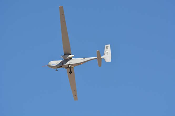
The U.S. Air Force has awarded a $48 million contract to Aurora Flight Sciences for the continued development of the Orion unmanned aircraft system (UAS). Aurora Flight is a Boeing company.
Orion is a twin-engine high-performance UAS that can stay aloft over 100 hours at a time with payloads in excess of 1,000 pounds.
Development of the Orion started in 2006 and its first flight was in August 2013. In December 2014, the Orion established the UAS world endurance record with an 80-hour, 2-minute and 52-second flight.
The new contract funds the development of a certified version of Orion that will be suitable for deployment anywhere in the world. The work will be performed in Columbus, Mississippi, and Manassas, Virginia.
Boeing completed the acquisition of Aurora Flight Sciences in November 2017.
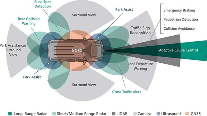
Renesas will use NovAtel’s high-performance SPAN tightly coupled GNSS and inertial navigation system (INS) technologies with GNSS correction services for live autonomous vehicles and advanced driver assistance systems (ADAS) demonstrations throughout CES.
SPAN GNSS+INS products provide position, orientation and time solutions that are critical for autonomous applications.
NovAtel’s assured positioning technology not only delivers solutions based on signals from satellite constellations but also uses vehicle behavior modelling, inertial sensor integration and GNSS correction signals to improve accuracy and significantly reduce interruptions in availability.
Image: NovAtel
Renesas relies on NovAtel products to provide high integrity and accurate positioning for autonomous driving, ADAS, connected car feature demonstrations and automotive solutions that will be showcased at CES 2018.
With the commitment to ensure autonomous vehicles have assured positioning solution, a team of engineers formed the Safety Critical Systems Group at NovAtel to meet the exceptional performance and safety requirements of autonomous vehicles at the necessary production volumes and price point required.
Since its formation, the group has made many positive partnerships in the automotive industry.
NovAtel and Renesas are currently collaborating on implementing NovAtel’s high-performance GNSS+INS positioning solution with the Renesas R-Car H3 system-on-chip (SoC). The R-Car H3 is compliant with the ISO 26262 functional safety standard for automotive applications, which aligns with NovAtel’s automotive strategy.
NovAtel has a long history providing industry leading high-precision GNSS solutions that are high quality and reliable. As an ISO 9001 certified company, NovAtel is also developing an extensive product line of receivers, antennas, correction signals, positioning algorithms, sensor fusion solutions and systems that fulfill specific safety requirements of the automotive industry such as ISO 26262.
Q: How will safety issues raised by increasing autonomous traffic — in the air and on roads — affect the GNSS industry?
Sanchit Agarwal, VP, Field Operations, Nearmap
A: Due to increasing autonomous traffic, the GNSS industry will have to adopt the concepts of collective tracking mechanisms in the shared ecosystem. Inherently, all the cars/drones (rovers) will have the sensors to track the traffic “on-the-fly” and make intelligent navigation decisions, but in case of any system malfunction, the collective tracking of devices can facilitate “social” interactions between the rovers. This will serve as an added layer of security in case an autonomous social member goes rogue!
Zak M. Kassas, Assistant Professor, University of California, Riverside
A: Future autonomous vehicles will demand full situational awareness and extremely reliable, accurate and secure navigation systems. GNSS will not meet the stringent demands of these autonomous vehicles. To address the inevitable situations where GNSS signals become unusable (due to attenuation or interference) or untrustworthy (due to spoofing), receivers should be coupled with sensors such as IMUs, lidar and cameras, and exploit the plenitude of ambient signals of opportunity such as cellular, digital TV and Wi-Fi.
Jonathan Auld, VP of Engineering and Safety Critical Systems, Novatel
A: Safety issues raised by increasing autonomous automotive and airborne traffic will escalate the product development standards and performance requirements of GNSS software, hardware, and correction services used. The GNSS industry is challenged to increase accuracy on lower cost platforms by utilizing multi-frequency, multi-constellation, sensor fusion and precise point positioning. To be able to rely on GNSS in auto-guidance applications, the industry also needs to incorporate GNSS integrity functionalities into our products.
BAE Systems and the University of Manchester has successfully completed the first phase of flight trials with MAGMA — a small-scale unmanned aerial vehicle (UAV) that uses a blown-air system to maneuver. The UAV design paves the way for future stealthier aircraft designs, according to BAE Systems.
The new concept for aircraft control removes the conventional need for complex, mechanical moving parts to move flaps that control the aircraft during flight. The new design could provide greater control as well as reduce weight and maintenance costs, allowing for lighter, stealthier, faster and more efficient military and civil aircraft.
The two technologies to be trialed using the jet-powered MAGMA, are:
Wing Circulation Control, which takes air from the aircraft engine and blows it supersonically through the trailing edge of the wing to provide control for the aircraft.
Fluidic Thrust Vectoring, which uses blown air to deflect the exhaust, allowing for the direction of the aircraft to be changed.
The flight trials are part of an ongoing project between the two organizations and wider long-term collaboration between industry, academia and government to explore and develop innovative flight-control technology.
Further flight trials are planned for the coming months to demonstrate the flight control technologies with the ultimate aim of flying the aircraft without any moving control surfaces or fins. If successful, the tests will demonstrate the first use of such circulation control in flight on a gas turbine aircraft and from a single engine, BAE Systems said.
“The technologies we are developing with the University of Manchester will make it possible to design cheaper, higher performance, next-generation aircraft,” said Clyde Warsop, engineering fellow, BAE Systems. “Our investment in research and development drives continued technological improvements in our advanced military aircraft, helping to ensure UK aerospace remains at the forefront of the industry and that we retain the right skills to design and build the aircraft of the future.”
“These trials are an important step forward in our efforts to explore adaptable airframes. What we are seeking to do through this programme is truly ground-breaking,” said Bill Crowther, a senior academic and leader of the MAGMA project at The University of Manchester.
Additional technologies to improve the performance of the UAV are being explored in collaboration with the University of Arizona and the NATO Science and Technology Organisation.
Drone operational rules have quite a few restrictions, largely aimed at keeping unmanned aircraft away from manned and commercial aircraft operations. The Federal Aviation Administration (FAA) has set a boundary limit for UAV operations to stay a minimum of 5 miles away from any airport. So it’s a little surprising that at least one airport is actually carrying on trials to fly drones within airport property.
The reason is birds. Most airports are large, open spaces where birds love to land in large numbers to seek food and to rest, so airports and aircraft have to cope with the problem of avoiding bird-strikes in the critical phases of take-off and landing.
Airports have used remotely compressed air cannons, and manually fired ordinance that “screams” or explodes making various forms of loud noise, or dogs or even hunting falcons of different species. Birds, however, become habituated to cannons and guns, and neither dogs nor hunting falcons can be relied on to actually herd birds away from runways.
All this is in an effort to drive flocks of birds away from runways and low-altitude aircraft traffic corridors. At high altitude, a bird strike is usually survivable and an aircraft still has sufficient energy to be able to glide in the event of a complete engine-out situation, giving the pilot time to find a landing place. U.S. Air’s Chesley Sullenberger was a great airman to save his passengers and aircraft, but he was also lucky to have the Hudson right there to ditch into. He was some cool dude when he put his Airbus A320 down on the river, once losing both engines at low altitude on take-off after flying through a flock of Canada Geese.
Enter Robird, a drone that looks — and behaves, in the right operator’s hands — like a female peregrine falcon, with flapping wing propulsion and attack moves emulating the predatory bird. Flown by a pilot and accompanied by an observer whose primary job is to ensure the UAV “bird” stays away from runways, the pair seeks resting flocks of birds that pose risk to aircraft within the boundaries of an operational airport.
https://youtu.be/-gc8kBmzOOI
Clear Flight Solutions in Holland has recently undertaken a trial at Edmonton airport in Alberta, Canada, where it obtained special flight clearance to fly within the airport grounds to demonstrate how its mechanical falcon could clear birds away from airport danger zones.
Of course, drones and aircraft don’t mix either, so flight rules within the drone systems (GPS/autopilot?) apparently include geofenced no-go areas corresponding with runways and approach areas, and there is a shutdown mode in case of loss of signal or other failure — avoiding runway incursion is all important.
Registration is back on
Since U.S. Federal Aviation Administration (FAA) regulations requiring registration of small UAVs (sUAV) and model aircraft were struck down last spring by the appeals court, the need to register has been in abeyance. However, Congress has rolled a new requirement back into the recently signed $700 billion National Defense Authorization Act, making registration of any sUAS or recreational model aircraft a legal requirement, subject to fines for lack of compliance.
The FAA has continued to advocate registration as a means to track wayward operators and to enforce separation of drones from manned aircraft. AUVSI has also continued to support the FAA position. A 2012 law, on the other hand, was said to prevent the FAA from making rules covering “model aircraft,” defined as “unmanned aircraft” flown for recreational purposes.
The new regulation within the Defense Authorization Act has now apparently clarified and overcome any contradictions — recreational model aircraft and drones all have to be registered.
DJI claims and counter-claims
The U.S. Immigration and Customs Enforcement’s (ICE’s) recent claims that manufacturer DJI could be spying for the Chinese Government have been refuted by DJI.
DJI has responded that allegations are wrong and that ICE should consider withdrawing or correcting unsupportable assertions. But claims persist that the Chinese government may be using information gathered by DJI UAVs to target potential assets for purchase.
A large wine producer in California used DJI UAS to survey its vineyards and monitor grape production, but soon afterwards a number of Chinese companies apparently purchased vineyards in the same area. So it’s being alleged that the companies appear to somehow have used DJI data.
DJI UAVs collects reflective images of leaves to calculate the nitrogen levels of plants using a specialized infrared scanner. The scanner enables growers to deduce how much nitrogen to add to the soil to optimize plant growth. Information on the location and stages of crop growth can also be collected. As of May, it’s been reported that DJI’s only customers using this particular scanner were wine producers along California’s Pacific Coast.
Most UAVs would seem to be capable of collecting location and geographic information data; however, these claims are being leveled at manufacturer DJI. In a website statement, DJI denied any wrongdoing but hinted that some of its data storage may have been compromised.
This story may be far from over.
Potential new aircraft control systems?
I recall climbing around in the fuselage of a Jet Provost training jet back in my apprenticeship years at BAE in the UK — I was wiring in auxiliary systems. But the thing I remember most was the mass of control cables running down the top center of the aircraft and winding their way to control surfaces via pulleys, with in-line tensioners and rubber lined holes to pass through bulkheads. I thought, How reliable could this be? Of course, it’s the way almost every aircraft control system has been constructed since Wilber, Orville and wing-warping. Up until we got fly-by wire and electrical actuators, that is — then mechanical cables became less prevalent, except for reversionary back-up.
But making surfaces pop up into the airstream around an aircraft is how we’ve been able to take off, maneuver and land aircraft/UAVs — up to now. Elevators, rudders, ailerons, leading and trialling edge flaps, speed brakes — all of them control pitch (up and down), yaw (left to right), roll and manage lift. These mechanical control surfaces sprout out of the wings and horizontal and vertical stabilizers, and provide control for the pilot, autopilot or onboard flight computer.
Now BAE Systems and Manchester University (MAN U) in the UK have come up with a different way to control a flying vehicle without using moving control surfaces. If the smooth surfaces of a stealth aircraft were to be never disturbed, the stealth radar signature of the vehicle would remain unchanged even during maneuvering — a handy enhancement to have to keep an aircraft as invisible as when it’s “clean” in level flight.
The BAE/MAN U innovation, incorporated into a new MAGMA drone, uses internal, redirected air from the engine to “blow” the aircraft into a different direction. The small demonstration UAV has apparently completed a successful first flight.
These innovations could both reduce mechanical complexity and improve the integrity of a stealth signature, by removing conventional control surfaces. Wing circulation control redirects supersonic air from the engine and blows it through the trailing edge of the wing. Thrust vectoring changes the direction of the aircraft’s exhaust.
When used together, these control the direction of the aircraft by manipulating the air around it. Hydraulic and electrical actuators have been replaced by air redirecting ducts and air blowers, which may simplify build and flight controls without making the air vehicle more visible to radar. Of course, taking additional airflow from the engine means the engine has to be more powerful to provide the additional airflow, so this doesn’t come for free.
The technologies being developed may enable cheaper, higher performance, next-generation aircraft. Its hoped that R&D will contribute towards technological improvements for advanced military aircraft. These trials are an important step forward in the exploration of adaptable airframes — along with other work to improve the performance of UAVs in collaboration with the University of Arizona and NATO Science and Technology Organization.
MicroPilot adds sense and avoid
MicroPilot in Manitoba, Canada, is a leading supplier of autoflight solutions for the UAS industry. The latest MicroPilot autopilots include integrated control datalinks, and they are small, lightweight and interface with a wide range of sensors. MicroPilot has now integrated its UAV autopilot with the FLARM sense and avoid system, adding an essential element for autonomous and beyond-visual-line-of-sight (BVLOS) operations.
FLARM is a traffic awareness and collision avoidance technology used by light aircraft and UAVs. When integrated with MicroPilot’s autopilot, the system alerts the autopilot of any close-by, suitably equipped aircraft. FLARM outputs the velocity and altitude of these detected targets, and the autopilot then decides how to avoid them.
FLARM collision avoidance systems, used by manned aircraft for more than a decade, now come with an ADS-B out option that broadcasts the UAV’s position to alert other aircraft to its location. Together, the MicroPilot autopilot and integrated FLARM system offer a unique combination of automated flight control and sense-and-avoid capability for UAS developers.
Summary
So bird-hunting, wing-flapping, bird-like UAVs being used to clear airports to prevent collisions between birds and aircraft; you will need to put down your $5 registration fee with the FAA if you want to fly your own UAV because new legislation has replaced that previously struck down in the courts; DJI and the U.S. ICE seem to be on some sort of a collision course; BAE and MAN U appear to be on the verge of a potentially revolutionary system with which to affect flight control of aircraft and a combined system for autoflight and collision avoidance — just a few of the many things happening this month in the UAV industry.
Harxon has launched the HX-DU2017D, a frequency-hopping OEM modem designed to provide strong anti-jamming and signal receiving capability for complex data-intensive applications.
HX-DU2017D is a miniature, dual-frequency, software-selectable 840 MHz and 900 MHz data link modem. It provides a power switching of 0.5 W, 1 W and 2 W, 20 ms/30 ms/40 ms/50 ms/ frequency hopping interval, and supports point-to-point, point-to-multipoint network.
Its full duplex mode ensures secure data transferring and stable long-range communication, the company said.
HX-DU2017D also provides short latency of data transmission and communication recovery in millisecond level.
According to Harxon, HX-DU2017D allows fast and secure, simultaneous data communication for mission-critical applications, especially in the fields of precision agriculture and UAVs, including unmanned plant surveys, UAV plant protection and automatic mowers.
It could easily be placed on a UAV with its extremely small footprint for tight OEM integration and design flexibility. Meanwhile, its frequency hopping transmission ensures the data security and flight stability.
A free Cognizant Autonomous Systems for Safety Critical Applications (CASSCA) Workshop will be held 8:30 a.m.-5:30 p.m. on Jan. 29 at the Hyatt Regency Reston in Reston, Virginia. This is scheduled to take place the day before and at the same location as the Institute of Navigation’s International Technical Meeting and Precise Time & Time Interval Systems and Applications (ION ITM/PTTI) 2018 conference.
The workshop consists of a full day of presentations and discussions on the opportunities and challenges associated with developing fully autonomous systems that are cognizant and trustworthy for safety-critical applications by leading experts in the field. Speakers include:
David Corman, Program Manager, Cyber-Physical Systems Program; National Science Foundation (NSF). Dr. Corman’s current research interests are in the field of Cyber Physical Systems (CPS), security for CPS, unmanned systems, manufacturing, and technologies supporting Smart and Connected Communities.
Paul DeBitetto, Vice President, Software Engineering; Top Flight Technologies. Dr. DeBitetto leads all Top Flight’s Software and Embedded Systems Development. That includes product-related flight control, simulation, computing, sensing, data communications, security-related controls and software solutions.
Finch Fulton, Deputy Assistant Secretary for Transportation Policy; Department of Transportation (DOT)
Joao Hespanha, Professor and Chair of Department of Electrical and Computer Engineering; University of California, Santa Barbara. His current research interests include hybrid and switched systems; multi-agent control systems; distributed control over communication networks (also known as networked control systems); the use of vision in feedback control; stochastic modeling in biology; and network security.
Robert Peterson, Professor and Director of Center for Insurance Law and Regulation; Santa Clara University.
Mr. Peterson teaches torts, insurance law and regulation, evidence and products liability, and other courses. He is a past chair of the California State Bar Standing Committee on Insurance Law, and is director of the Law School’s Center for Insurance Law and Regulation.
Signe Redfield, Roboticist and Mission Manager; Naval Research Laboratory (NRL). Dr. Redfield’s primary interests include performance evaluation of autonomous systems, foundations of robotics, and cooperative behaviors for autonomous underwater vehicles.
Giorgio Rizzoni, Professor and Director of Center for Automotive Research (CAR); The Ohio State University. The CAR is an interdisciplinary university research center that conducts research on advanced automotive and transportation technologies and systems engineering, focusing on sustainable mobility, advanced propulsion systems, human safety and the environment.
Steven Rogers, Senior Scientist for Automatic Target Recognition and Sensor Fusion; Air Force Research Laboratory (AFRL). Dr. Rogers serves as the principal scientific authority and independent researcher in the field of multi-sensor automatic target recognition and sensor fusion.
Registration is also now open for the ION International Technical Meeting (ITM) and Precise Time and Time Interval Systems Applications Meeting (PTTI), which begin the next day (January 30-February 1) at the same location. See www.ion.org/itm for more information.
Long established as a key component within defense applications, navigation technology from Honeywell is now available to a wide range of new industries that can benefit from the advanced precision and performance of reliable, rugged and easy-to-install inertial measurement units (IMUs).
Honeywell’s newest IMU offering — the HG4930 — applies the principles of reliability, dependability and performance from aerospace and defense. It’s tailored for “straight out of the factory” integration and use in various non-defense and non-aerospace industrial applications, the company said.
Applications include autonomous vehicles, surveying and mapping, ground and underwater robotics, unmanned aerial vehicles and gimbal stabilization.
IMUs help people, vehicles and machines measure motion and calculate changes in position, anywhere in the world, even where GPS signals are intermittent. In industries where automation is taking hold and working conditions where GPS may be out of touch, an IMU can help fill in the moments of disconnect and keep things like an autonomous underwater vehicle or a robot in a factory informed about how they are moving relative to their surroundings.
“For more than a decade, we’ve designed our IMUs to perform in the extremely harsh and demanding environments for our aerospace and defense customers,” said Chris Lund, senior director, industrial IMUs, Honeywell Aerospace. “But there is no shortage of possibilities for how that same IMU technology can support a wealth of markets hungry for the next level of enhanced navigation and control. The HG4930 tactical grade IMU is a highly competitive and cost-efficient variant of our industry-leading navigation technology. Whether helping your industry evolve toward autonomy or augmenting a platform or solution’s precision in domains where GPS is unreliable, the HG4930 delivers the needed performance.”
In addition to the HG4930 IMU being an extremely small, lightweight and low-power product for spearheading new uses or bolstering current navigation capabilities, Honeywell’s HG4930 IMU is not classified under an International Traffic in Arms Regulation category, but instead is free from the burden of an export license for all but a few military-related use cases. This means a broader availability for customers around the world.
With more than 500,000 tactical-grade IMUs produced to date, the HG4930 builds on a proven Honeywell legacy of reliable inertial technologies. According to Honeywell, it is the highest-performing microelectromechanical system (MEMS)-based IMU of its size and price, and benefits from world-class inertial sensor development, calibration and compensation.
The HG4930 has been tailored to provide significantly improved gyroscope and accelerometer performance for the environments and use cases experienced by non-aerospace and non-defense users.
For industries that depend on less reliable MEMS or large, power hungry and expensive fiber-optic gyroscopes for navigation and control capabilities, the HG4930 offers three off-the-shelf performance grades for easy replacement and new capability.
Lear Corporation, a global supplier of automotive seating and electrical systems, has entered into a definitive agreement to acquire Israel-based EXO Technologies, a developer of GPS technology providing high-accuracy solutions for autonomous and connected vehicle applications.
EXO Technologies has operations in San Mateo, California, and Tel Aviv, Israel. Financial terms of the transaction were not disclosed.
EXO Technologies has developed core technology that addresses the need for high-accuracy positioning in a vehicle. Its proprietary technology works with existing GPS receivers to provide centimeter-level accuracy anywhere on the globe without the need for terrestrial base-station networks.
EXO Technologies offers a software-based GPS approach — PICO pinpoint positioning software — that enhances GNSS receivers. By correcting satellite orbit error and clock error, it eliminates the inherent error sources within navigation messages. Its algorithms reduce complementary errors and construct a full positioning solution.
The integration of EXO’s technology with Lear’s vehicle and connectivity expertise will enable a superior vehicle positioning solution, the companies say.
“EXO has developed technology that is essential for the future of connected and autonomous vehicles,” said Nuri Golan, EXO co-founder and CEO. “We are extremely excited to join the Lear family where we will provide unparalleled solutions for vehicle-to-vehicle, autonomous driving and other applications.”
“Lear is a leader in automotive connectivity solutions including Vehicle-to-Vehicle and Vehicle-to-Infrastructure communications,” said Matt Simoncini, Lear’s president and chief executive officer. “The acquisition of EXO Technologies will provide Lear with a differentiated technology to significantly improve GPS accuracy and reliability, thereby enhancing vehicle safety and enabling autonomous driving.
“The combination of EXO Technologies with Lear’s existing resources further strengthens our connectivity capabilities,” Simoncini said. “We see excellent growth opportunities for our E-Systems business as the proliferation of connected and autonomous vehicles will drive increased demand for improved accuracy and reliability in vehicle positioning.”