Digital Mapping Group, a pioneer in high-accuracy GNSS solutions for more than two decades, has released FastXY, a powerhouse mapping application for iOS and Android.
FastXY is designed to transform standard mobile devices into professional-grade data-collection tools for geospatial information system (GIS) and architecture, engineering and construction (AEC) professionals.
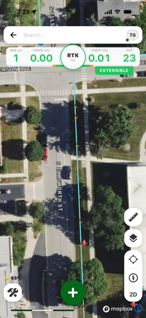
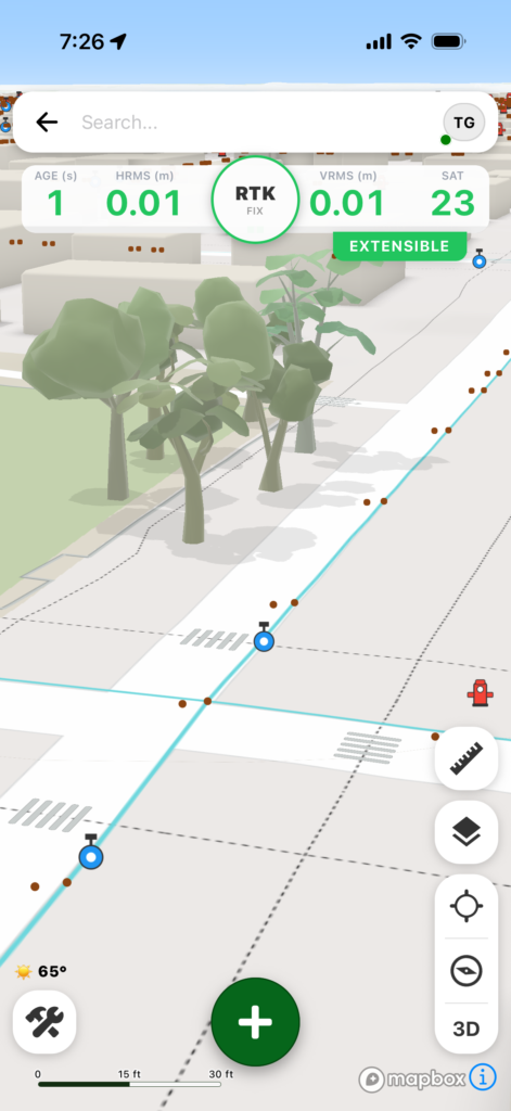
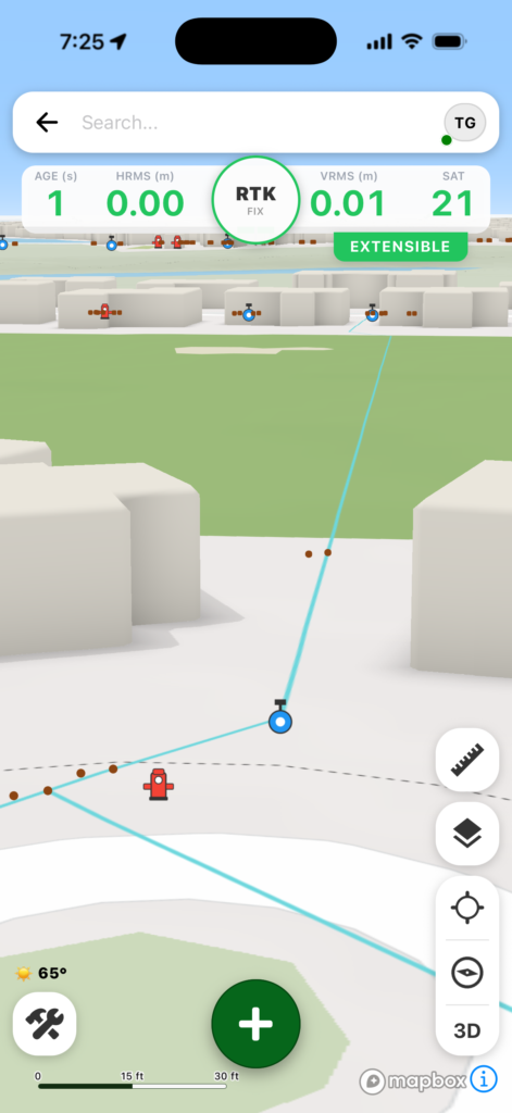
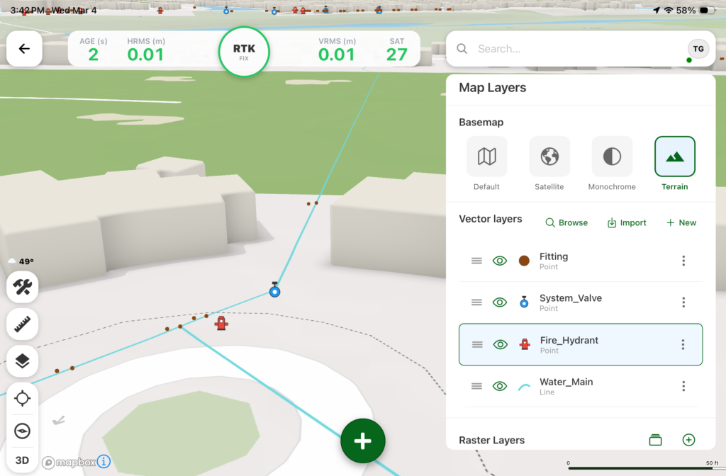
As the industry shifts away from bulky, proprietary hardware, FastXY offers professionals the ability to collect point, line and polygon data with the devices already in their pockets. Unlike “lite” mapping apps, FastXY delivers advanced capabilities including 3D basemaps, construction staking, topographic surveying, on-the-fly datum transformations, and survey-grade elevations.
Credit: Digital Mapping GroupCredit: Digital Mapping GroupCredit: Digital Mapping GroupCredit: Digital Mapping GroupCredit: Digital Mapping Group
One of FastXY’s most disruptive features is its built-in Bluetooth data parser. This allows users to configure the app to collect data from virtually any instrument supporting BLE Bluetooth or RS-232 — including echosounders, radiation sensors, laser rangefinders, barcode scanners and more — and marry that data instantly with precise GNSS coordinates.
“Our goal to create the most useful GNSS field data collection software for iOS/Android that uses the latest software tools,” said Ryan Skeele, software engineer. “The power of iOS/Android mobile devices increases every year, and we intend to iterate quickly to provide users more powerful solutions in the field.”
Available in two versions: Free and Premium
Essentials (free version)
High-accuracy ready. Works with device internal GNSS or Eos Positioning Systems’ Bluetooth receivers.
Offline-first approach. No internet connection required for field editing/data collection.
Rich visualization. 3D basemap featuring satellite, terrain and building overlays.
Smart logic. Attribute picklists with computational operations.
Survey-grade datum support. Real-time horizontal and vertical datum transformations.
Professional powerhouse (premium version)
Advanced point staking, auto-topographic data collection and cross track navigation.
Hardware integration. Full support for Eos Positioning Systems’ Skadi Tilt compensation and Smart Handle hardware.
Sensor hub. Connect to echosounders, laser rangefinders, barcode readers, radiation sensors, and other instruments with the external instrument configurator.
Advanced field workflow. Import Trimble Data Dictionaries, CAD/GIS files, KMZ/KML, and drone-captured raster imagery.
Post-processing. RINEX data collection and direct OPUS submission for static post-processing.
“We’re excited to offer an app for high-precision AEC users that runs on the mobile device in your pocket,” said Eric Gakstatter, principal GNSS consultant and former GPS World survey editor. “Separately, the unique Sensor Hub feature allows FastXY to consume data from almost any external instrument, combining it with high-precision GNSS data.”
FastXY is available for download today on the Apple App Store and Google Play. For more information, visit fastxy.com.
Digital Mapping Group
Founded 24 years ago, Digital Mapping Group has deployed tens of thousands of high-accuracy GNSS solutions globally. Their expertise spans utilities, public works, AEC, environmental, transportation and government sectors.
Singular XYZ has released the Sfaira One GNSS receiver. The portable size, centimeter-accurate receiver provides users with an entry-level network real time kinematic (RTK) rover.
Sfaira One is equipped with a GNSS module with 1,408 channels for GPS, BDS, GLONASS, Galileo and QZSS tracking — providing centimeter positioning in harsh environments. It also features advanced RTK and an anti-interference algorithm.
The GNSS receiver connects via Bluetooth and can be configured to conduct surveying tasks on a smartphone. Additionally, Sfaira One supports SingularPad and SingularSurv software and is also compatible with mainstream field survey or GIS software.
Sfaira One is IP65 dustproof and waterproof, which makes the receiver suitable for all weather conditions. It has a 4,800 mAh battery life with 16 hours working time and type-C interface that can be charged on-the-go with power bank.
The Sfaira One GNSS receivers are online at SingularXYZ’s website and are available now.
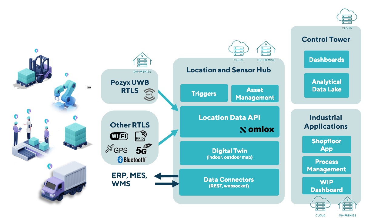
The Pozyx Platform is an asset tracking and identification solution for seamless indoor and outdoor tracking, based on the omlox hub and supporting multiple location technologies.
The omlox hub is an open standard for real-time location systems (RTLS) that combines location data from GPS, ultra-wideband, 5G, radio-frequency identification, Wi-Fi and Bluetooth.
The Pozyx Platform offers a seamless indoor/outdoor transition with zoom-in from a worldwide map to a detailed indoor map, showing highly accurate locations up to 10 cm. It is designed for smart manufacturing, providing a supply-chain solution that supports Industry 4.0.
It tracks and identifies any asset, providing real-time data to facilitate warehouse and inventory control, keep track of critical tools, and slash lost asset costs.
Leveraging Bluetooth direction finding technology, the solutions demonstrate sub-meter level position accuracy for a variety of industrial and consumer applications
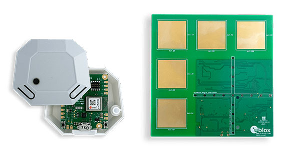
Photo: U-blox
U-blox has released two explorer kits for product developers to evaluate the potential of Bluetooth direction finding and high-precision indoor positioning. Designed for low power consumption, simple deployment, and low cost of ownership, the u-blox XPLR-AOA-1 and XPLR-AOA-2 explorer kits will test the technology’s capabilities to enable a variety of applications including access control, collision detection, smart appliances, indoor positioning and asset tracking.
Recognizing the growing demand for more accurate indoor positioning solutions, the Bluetooth special interest group (SIG) released Bluetooth direction finding, offering a major improvement over previous receiver signal strength indicator (RSSI)-based solutions.
Bluetooth direction finding makes it possible to determine the direction that radio signals travel from a mobile tag to one or several fixed anchor points. Using angle-of-arrival (AoA) technology, anchor points comprising antenna arrays connected to Bluetooth receivers can detect the direction, or angle, to the mobile tag, which transmits a Bluetooth signal. When a constellation of such multi-antenna anchors is deployed, AoA technology can be used to triangulate the precise location of a mobile device or tag.
The u-blox XPLR-AOA-1 and XPLR-AOA-2 explorer kits showcase one of the first complete Bluetooth-based tracking solutions – from the tag to the cloud – to reliably offer sub-meter-level accuracy in indoor environments.
Eos Positioning Systems, the global manufacturer of Arrow Series GNSS receivers, has released Eos Bridge, which enables almost any instrument to become iOS Bluetooth compatible.
Photo: Eos Positioning
The Eos Bridge is a small, pocket-sized device that connects to instruments via Bluetooth Classic or serial port, and transmits data from them to any Apple iOS device, such as iPhone or iPad, Android device or Windows mobile device.
The Eos Bridge offers two connectivity methods to virtually hundreds of instruments:
First Method: Bluetooth Classic to Apple iOS Bluetooth
Instruments that are equipped with non-iOS Bluetooth are now able to connect to Apple iOS devices using the Eos Bridge, including laser rangefinders and utility-locating instruments.
Second Method: Serial port to iOS, Android and Windows devices
With the Eos Bridge, instruments whose only connectivity option is a serial port may now be connected to any iOS, Android or Windows device via Bluetooth. This includes any instrument or sensor with an RS-232 serial port, for example.
The Eos Bridge is lightweight, at approximately 150 grams (about 5.3 ounces). It can be worn clipped to a belt, stored in a pocket, or mounted to an instrument or sensor. The battery lasts 48 to 72 hours.
The Eos Bridge expands the potential pairings of legacy instruments and sensors by making them Bluetooth compatible with modern mobile devices and Arrow GNSS receivers. Two immediate applications for current Arrow GNSS users include Eos Laser Mapping for ArcGIS offset data-collection, and Eos Locate for ArcGIS for underground utility mapping. Both solutions are available on iOS.
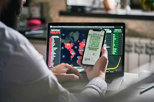
According to a study by Future Market Insights, the contact tracing applications market is set to grow 15% CAGR through 2030.
“Functional advantages of contact tracing applications include superior data quality, easier tracking and monitoring of larger numbers of people in a time effective manner, the ability of real time analysis, and the significant improvements to management and coordination of manual contact tracing teams,” said a lead analyst at Future Market Insights.
Key highlights noted in the report include that the market for contact tracking applications is projected to display exponential growth through the forecast period on the back of the ongoing coronavirus crisis; decentralized, Bluetooth-based applications are likely to gain strong traction as a result of data privacy concerns; Android platforms are likely to contribute significantly to adoption owing through higher penetration of associated smartphone models; and Europe is expected to be a prominent market, with East Asia showing lucrative growth prospects on the back of mandatory use in China.
COVID-19’s impact on the contact tracing applications market
The COVID-19 pandemic has played a role in the contact tracking application market’s growth: according to the study, the pandemic has been the primary driver for the development, deployment and adoption of contact tracing applications. Government initiatives toward social distancing and patient tracking has influenced the industry’s growth, as well.
The study also has projected an increase in disease control applications as a result of the COVID-19 pandemic.
According to the study, countries such as Ireland and South Korea have been able to use contact tracing applications to gain promising results towards breaking chains of coronavirus patients, limiting the risks of community transmission.
Despite the market’s growth, demand for these applications has been limited to countries with high rates of smartphone penetration. In addition, ethical problems in terms of transparency, privacy and accountability have restrained adoption during this period.
“However, prospects for contact tracing applications remain positive for the post-pandemic era, owing to potential for use in controlling other infectious disease outbreaks worldwide, albeit at a smaller scale,” the report said.
This report analyzed various strategies employed by major companies operating in the contact tracing applications market. Some of the participants operating in the contact tracing applications market include IBM, Oracle, Microsoft, Apple, T-Systems, SAP SE, Salesforce.com, Siemens AG and ServiceNow.
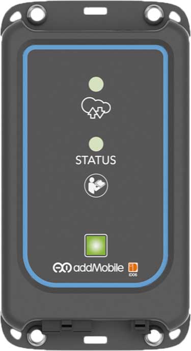
u-blox’s Bluetooth low-energy module NINA-B1 has been chosen by AddMobile, Swedish provider of devices and services for construction site management, as the basis of its short-range equipment-tracking beacons, AddTrackers.
Photo: AddMobile
In addition to NINA-B1, the AddMobile Toolbox features the u-blox MAX-M8 GNSS module and the u-blox GSM/GPRS cellular module SARA-G3.
AddTrackers is among the latest enhancements to the company’s AddMobile Toolbox platform and involves adding radio beacons to any tools or equipment that need tracking.
The AddMobile Toolbox helps site managers control mobile work orders, log fleet vehicle mileages, secure entry to work sites, register staff as they come and go, as well as handling fleet management and equipment safety.
It uses a variety of hardware to enable these Connected Construction Site’s services, including stationary hubs and entrance control units with Bluetooth low-energy and cellular connectivity, as well as an RFID reader, and mobile hubs with GNSS, Bluetooth low energy and cellular connectivity.
“The AddTracker beacons and hubs rely upon a combination of GNSS positioning, cellular connectivity, and Bluetooth low energy short-range radio interfaces,” said Bo Lyvall, business development manager at AddMobile. “U-blox was able to provide all three key technologies for our solutions, as well as providing great local support in the Malmö area.”
In use, the beacons equipping tools and equipment communicate with suitably equipped smartphones or other AddMobile hardware infrastructure. When one of these devices picks up an asset’s signal, the asset’s unique ID and GNSS coordinates are sent to AddMobile’s cloud platform, which can then show managers an image of the asset and its position on a map, list the equipment’s features, and show where it is on its planned maintenance schedule.
Trackers don’t have to be static. In one use case, a vehicle is fitted with a mobile hub that includes a GSM connection, GNSS positioning, and a Bluetooth low energy interface in the luggage area.
Tools can be tracked on-site by static hubs, and then followed as they are put into company vans for use offsite. This means that staff scheduling offsite jobs can know the location of all their mobile personnel, and whether they have the right tools with them to undertake each task.
The company was also attracted by the cost efficiency of u-blox’s offering, and what is already a vast installed base of interoperable Bluetooth low energy technology. In the future, the collaboration between AddMobile and u-blox may extend to the use of a longer-range variant of Bluetooth, to further reduce the cost of asset tracking on large and complex sites, and exploring the appropriate use of cellular technology in asset tracking.
From left: Left to Right: Esri Director of Global Business Development Jeff Peters, Eos Sr. Marketing & Content Strategist Sarah Alban, Eos CTO Jean-Yves Lauture, Esri President Jack Dangermond. (Photo: Eos Positioning)
The award for “Energizing the Market with a Bundle” recognizes Eos’ seamless integration of its Arrow Series GNSS receivers with Esri mobile apps.
Eos Positioning Systems Inc., provider of submeter Bluetooth GPS and GNSS solutions, has received a 2019 Esri Partner Conference award in recognition of Eos’ contributions to Esri mobile applications.
Esri ArcGIS users benefit from bundling the Eos Arrow GNSS receivers and Esri mobile apps to create real-time, high-accuracy field GIS solutions on consumer devices such as iPads, tablets, and smartphones.
Photo: Eos Positioning
“As a long time Esri partner, this ‘Energizing the Market Award’ highlights the ongoing value Eos brings to our shared customers,” said Francis Kelly, Esri manager of Global Partner Programs. “Their thoughtful approach to connecting the field worker to the enterprise GIS creates customer satisfaction and significant ROI across our business sectors.”
“Eos has done tremendous work bringing affordable high-accuracy receivers to the Esri user community, whilst taking advantage of the latest Esri technology including Collector for ArcGIS and Survey123 for ArcGIS,” Esri Canada Director of Strategic Alliances Paul Salah said. “I couldn’t be more pleased to have them recognized for their innovation that brings such great value to field workers everywhere.”
Eos’ mission is to turn the complex world of high-accuracy submeter and RTK location into simple and affordable integrations to the Esri ArcGIS platform. This is achieved with behind-the-scenes transfers of high-level GNSS information with Esri mobile apps.
The exchange is nearly transparent to the end-user, and therefore minimizes the knowledge required for anyone to capture survey-grade 3D locations.
“It used to be really hard to collect high-accuracy data,” said Christa Campbell, Esri Global Water Practice Industry Specialist. “But now it’s very easy and affordable, so there are no limits any more. Anyone can do it.”
2018 saw small-system water utilities, municipalities, consultancies, co-ops and others adopt high-accuracy GIS at increasing rates. Eos believes this is due to a changing understanding of how easy and affordable high-accuracy data collection can be with the Eos/Esri bundle.
“We are showing that anyone can map an entire system, regardless of the size or the person’s familiarity with GNSS and GIS,” Eos CTO Jean-Yves Lauture said. “We are showing that it is simple, affordable, and profitable.”
The adoption of high-accuracy solutions among GIS users coincides with a general shift toward digitized asset management, away from paper maps and CAD drawings.
The shift is the natural result of more affordable and easier to use technologies, the proliferation of smart devices, and industry trends including increased regulations.
“Now more than ever, customers want to start taking advantage of the tremendous flexibility GIS has to offer,” Lauture said. “And the first step in creating an accurate system of record is field mapping with GPS.”
In 2018, Eos released two new innovative solutions for ArcGIS users.
The first was the result of a three-way partnership between Eos, Esri and Laser Technology, Inc.
Known as the “World’s First Laser Offset for Collector for ArcGIS,” this laser mapping solution allows field workers to collect highly accurate (submeter or centimeter) locations on their iPads and iPhones in otherwise challenging environments.
This includes GNSS-impaired environments, where view of the sky is obscured or limited, and places where occupying an asset would be unsafe or expensive (such as a manhole located in a road intersection).
“With the new collector-based laser mapping solution, organizations can save money, minimize risk and boost the efficiency of their field operations,” Esri Field Apps Product Lead Jeff Shaner said. “Without having to occupy assets in challenging environments, field workers can capture asset locations within inches of accuracy using the Eos Arrow and LTI rangefinder. This unique partnership provides advanced field data collection capabilities and drives new opportunities to extend the reach of ArcGIS.”
The second solution feeds real-time orthometric heights (Z values) directly into Collector and Survey123 for ArcGIS. By supporting real-time GEOID models, Eos eliminates the need to transform ellipsoidal heights into local vertical datum manually back at the office. This reduces time-consuming post-processing as well as makes accurate elevations instantly available for use in the field.
Eos is dedicated toward providing its customers with innovative solutions like this, which allow Esri users to stay within their existing ArcGIS mobile environments.
“This award acknowledges the work Eos has accomplished so far in bringing innovative solutions to our mutual customers with Esri,” Lauture said. “It is quite an honor for everyone at Eos, and we are especially thankful to all the Esri employees who have made the journey in getting here so enjoyable. It’s what makes us look forward to doing more in the future.”
Bluetooth has added a new direction-finding feature to help meet the growing demands of the location services market.
The feature, which allows devices to determine the direction of a Bluetooth signal, was added to Bluetooth in version 5.1 of the Bluetooth Core Specification, released Jan. 28.
To make use of the direction-finding feature, Silicon Labs has released new software for the Wireless Gecko portfolio, a comprehensive connectivity solution for the internet of things (IoT).
Silicon Labs’ commercial, industrial and retail customers can enhance their location-based services — indoor navigation, asset tracking, space utilization and point-of-interest engagement — using the direction-finding feature, the company said.
The new feature supports multiple methods for determining signal direction including angle-of-arrival (AoA) and angle-of-departure (AoD).
Silicon Labs’ implementation of the new Bluetooth feature enables detection of signal direction within 5 degrees.
To date, Bluetooth asset tracking and indoor positioning solutions have typically provided location accuracy within a range of 3-4 meters. With the Silicon Labs Bluetooth 5.1 solution, developers can create products that improve location accuracy down to the sub-1-meter level, opening the door to applications previously not possible.
“The Silicon Labs Bluetooth direction finding solution provides a huge leap in location services accuracy for the industry,” said Matt Johnson, senior vice president and general manager of IoT products at Silicon Labs. “The combination of the Silicon Labs wireless solution and the new features added in Bluetooth 5.1 will help developers transform industries and improve people’s lives.”
In addition to improved location services, Bluetooth 5.1 also helps developers:
reduce power consumption with sleep clock accuracy updates.
improve smart home connection performance using GATT caching functionality.
optimize beaconing for Bluetooth mesh in crowded RF environments with the advertisement channel index feature.
“The Bluetooth community continues to find ways to meet evolving market needs and open new opportunities,” said Mark Powell, Bluetooth SIG executive director. “The addition of Bluetooth direction finding demonstrates this commitment to drive innovation and support the incredible growth opportunity within the location services market.”
Silicon Labs’ direction-finding software, including support for the AoA method, is available to customers through the Silicon Labs Simplicity Studio development kit.
Orthometric height support (survey-grade elevations) enables Arrow GNSS receivers to collect high-accuracy, survey-grade vertical data with any data-collection software.
Eos Positioning Systems Inc. has added support for GEOID height models within its Arrow Series GNSS receivers. Eos manufactures high-accuracy GNSS receivers for any app running on iOS/Android/Windows devices and using the Eos Arrow Series.
“You can use Arrow Series receivers with any data-collection software in the world, and benefit from accurate orthometric heights,” Eos CTO Jean-Yves Lauture said. “Our Arrow receivers will output accurate GNSS elevations no matter which data-collection software you use to capture it.”
Image: Eos Positioning
With support for GEOID models, Arrow receivers automatically output survey-grade elevations to all iOS and Android data collection software. Support will also soon be available for Windows devices.
The Arrow receivers now support the entire United States to provide survey-grade elevation in NAVD88 orthometric heights through the GEOID12B (US) model. The Arrow receivers also support the Canadian CGG2013a and HTv2.0 GEOID models for the CGVD2013 and CGVD28 vertical datums, respectively. Additional GEOID models for other countries are planned.
“Eos is intensely focused on supporting high-accuracy GIS, engineering, surveying and construction users by supporting the latest GEOID elevation models within our GNSS monitoring software,” Lauture said. “Our roadmap remains focused on high-accuracy BYOD users by supporting all iOS, Android and Windows users with this capability.”
The problem is that typical Bluetooth GNSS receivers usually provide inaccurate, built-in elevation models. This inaccuracy is reflected in the Mean Sea Level elevation output by those receivers. By outputting orthometric height, the Arrow now solves this problem and turns any smartphone or tablet into a 3D, survey-grade accurate data collection device, the company said.
Eos has designed this new feature so that users will easily be able to update to new GEOID models as they become available.
Field technicians in pipeline, construction, engineering, architecture, water and any other industry are finally able to enjoy GNSS location with survey-grade vertical accuracy on their iOS and Android devices, with the data-collection app of their choice and their Eos Arrow receivers.
Telit GE310-GNSS IoT Module fills European demand for GSM/GPRS compact form factors, and is part of Telit’s migration-support program that helps customers leverage 2G’s low cost and broad coverage while preparing for 4G and 5G.
The GE310-GNSS module. (Image: Telit)
Telit has released the GE310-GNSS, an internet of things (IoT) module with GSM/GPRS, multi-constellation satellite positioning and Bluetooth functionality in a 270-millimeter-squared form factor.
The GE310-GNSS enables original equipment manufacturers (OEMs) and system integrators in application areas such as asset management, utilities and telematics, meet strong demand for low-cost, highly compact devices without tradeoffs in performance, reliability and functionality, particularly in regional markets such as Europe, where 2G is forecast to remain in strong growth in number of IoT connections for many years.
The GE310-GNSS features a miniature form factor packaged in an LGA 94-round-pad format. It is designed to meet the robust demand in Europe, Latin America and other regional markets for compact devices such as health and wellness monitors, smart residential and commercial thermostats, commercial fleets and IoT-connected grid equipment for smart utilities.
With support for Europe’s Galileo as well as other satellite positioning constellations, the GE310-GNSS is suitable for IoT applications that require location awareness throughout Europe and the rest of the world. The module’s Bluetooth 4.0 capability makes it easy for OEMs to add connectivity to proximal area network devices, Telit said.
The GE310-GNSS is part of Telit’s future-proofing program, which helps customers leverage 2G’s low cost and gapless European coverage immediately while retaining absolute control of when they switch to a compatible 4G module in the Telit family lineup.
The lineup includes multiple roadmap paths to upgrade to 4G and later to 5G based on the customer business strategies and specific market conditions.
Research firm ABI Research estimated in its “ABI IoT Market Tracker – Worldwide – October 2018” that 2G cellular IoT connections will continue to grow in Europe from 100 million in 2018, reaching a peak of 148 million connected devices in 2022 before slowly dropping to about 89 million in 2026.
“The GE310-GNSS is the newest in our lineup of updated 2G modules for markets like Europe and Latin America which still show a sustained pull for over half a decade,” said Yossi Moscovitz, president products and solutions, Telit. “This svelte module combines proven, reliable 2G connectivity with the latest satellite positioning and Bluetooth technologies, all backed by Telit’s decades-enduring migration-support program. Telit has helped thousands of customers through cellular generational transitions and is now helping 2G customers in Europe, Latin America and other regions develop business-enhancing roadmaps to 4G and 5G.”
For more information about the GE310-GNSS and other Telit IoT solutions, visit booth A.b80 at European Utility Week, Nov. 6-8 in Vienna, Austria.
June’s Geointelligence Insider article on Jack Maple was the human interest article. One of the readers of June’s article had the opportunity to meet Jack Maple. I appreciate the feedback. This month’s article is based upon the recommendation of Geospatial Solutions Managing Editor Tracy Cozzens to cover the technical side of GIS and crime fighting.
Recap
Fighting crime with GIS sounds simple enough — map where the crimes are happening and where the bad guys are and send in the cops. That would be a gross over simplification. As always, there’s more to the case.
The first CompStat was founded in the pre-internet days of 1994 on a Commodore 64, harkening back to the days of 128-MB floppy disks and MS-DOS, a Jurassic period of computer evolution that marked some of the first steps into crime fighting’s digital era. The graph above is the current CompStat 2.0 from the NYPD. It is a GIS-based system, interactive, user-friendly and available to the public. Take note of the highlighted number.
Since CompStat was introduced, crime has fallen precipitously. As of this writing (Aug. 25, 2018) New York City has 183 reported murders year to date. By comparison, in 1990, prior to CompStat, there were 217 murders per month on average. More murders were committed per month in 1990 in New York City than what it will experience in all of 2018. Murders have dropped nearly 90 percent. In other words, nine out of 10 who would otherwise have been killed are alive to return to their families, parents, classmates and colleagues, and friends. The difference is staggering, providing tangible proof geospatial science is a benefit to humanity.
The arsenal of geospatial applications available for the crime fighter is enough to make any superhero envious. The list of these high-tech, integrated intelligence systems push the limits of science fiction.
The underlying strength of these systems is the robust GIS/GPS platform they are built on. Security cameras are geospatially connected to the network with dynamic mapping capabilities. This allows the surveillance video to be overlaid on GIS software in order to interact with more information and create actionable intelligence.
Cameras use a host of software algorithms that are able to recognize aggressive behavior, patterns, anomalies, change detection, biometric features, objects and text. Systems can integrate real-time information like social media feeds as well as live video, including facial recognition software scans for wanted individuals in real time. This information is shared with police officers in the field.
Police cars are becoming mobile command centers outfitted with a suite of sensors, and will eventually include drones. Police officers wear smart glasses augmenting information about who they are looking at in an intelligence and location-based context.
The police officer’s belt is Bluetooth enabled, connecting all these devices, as well as monitoring the officer’s vital signs. The officer’s gun is also Bluetooth enabled, reporting when it is drawn, the direction it is pointed and if it fired. The gun also comes with a chip for tracking purposes and to ensure only the officer it belongs to can fire the weapon.
The vest-worn camera is woven into the seamless geospatial network of sensors and records the officer’s experience from a first-person perspective.
Imagine this scenario. A crowd gathers at an intersection triggering an anomaly detection sensor due to the number of people gathering in that location at that time. Out of the thousands of security cameras being monitored at the Command and Control Center (C3), this video scrolls around and flashes yellow, bringing attention to the possible situation. Other mounted cameras that have that intersection in the field of view automatically align along the edge of the main security video projecting their imagery onto a 3D data model of the area. Police officers in the field nearest to that location are simultaneously alerted. No action is taken at this point except the police begin heading in that direction. Facial recognition software scans the video images for faces of known suspects. Social media and texts scroll next to the video and geospatially link to those in each frame of the video. Colored sentiment indicators showed levels of concern. Boxes outlining people in various colors correspond to threat levels determined by datamining multiple databases. Semi-persistent motion trails lag behind each box showing the speed and direction of people in the video. Pattern identification looks for convergence, divergence and synchronous movements.
Video analytics identify several people converging on a car that just pulled up. The license plate reader linked to the security camera reports the car as stolen with two traffic violations. Based on this preliminary information, the situation is elevated. A police officer is dispatched but before arriving, a drone launches from the police car outfitted with a true color camera and a stereographic infrared camera. The stereographic imagery pair is streamed live to the police officers entering the area of interest through their smart glasses and to a team of imagery specialists at the C3. The video analytics of the police drone are seamlessly integrated with the security camera videos focusing on the car and the individuals as it arrives on scene and surveils the area. Object recognition identifies three possible weapons on the persons of interest. The boxes around those individuals turn red. They are tagged for persistent surveillance by all security cameras in the area. The order is given to apprehend them for probable cause. More police officers are called in and before they arrive they know who they are looking for, where the person is located, and that they may be armed and dangerous. In less than a minute, the police arrive. The suspects flee. The drone follows one of them up the street into an alley. Two of the officers pursue him. The other two suspects jump into the car and drive away. License plate readers and security cameras track the car on a map showing the vehicle’s route and speed with corresponding real-time video as the vehicle passes into view of each camera. As the vehicle travels south a police officer steps out from a cross street and shoots an electromagnetic dart into the speeding vehicle, disabling it. The police officers approaching the car shine a disorienting laser light weapon called a dazzler at the suspects, preventing their eyes from focusing. The occupants are apprehended without incident. They are searched for probable cause and arrested for carrying handguns without a permit.
The other suspect fled on foot. The drone followed him relaying live imagery to the police officers’ smart glasses. Their smart glasses showed a real-time map of their locations and the suspect’s. They cornered him in a fenced area. Guns drawn, the smoky red light of the laser cutting through the air pointed at the suspect. He surrendered. No gun was found on the suspect but the drone video the gun being thrown into a dumpster. One of the officers went back and retrieved the gun.
Gun traces were run on the three confiscated weapons and one was identified as stolen, matching a description of a gun used in a recent homicide. One of the suspect’s fingerprints match those found on shell casings at a nearby location reported by gunshot acoustic sensors. Based on this information, there is probable cause and a tap and trace is approved electronically by a special task force judge. The phone records of the three suspects are searched linking them to the el Diablo gang. Several unknown numbers are also in the call logs. Those numbers are added to the case file to be investigated later.
Only one of the suspects has a known address. The other two have no known location. Activity extracted from phone records show their whereabouts over the preceding days pin pointing their main locus of operation. Search warrants are issued. Within hours of arresting the suspects, the locations are raided and searched. Officers discover a cache of weapons, drugs, laptops and other useful information.
Everything described above is already available — it is only a matter of time and money. And, if Dubai is any indication of things to come, police could soon be arriving on hoverbikes.
The police arriving within minutes is key to the success of preventive policing. Time saves lives. The goal is to intervene before crime happens. But how is it possible? Before answering, let’s look at some numbers.
By the numbers
In 2017 almost 84 percent of the population of the United States was considered urban residing within 106,400 square miles. The Bureau of Justice Statistics reports there are only 758,854 sworn officers in the United States. Maintaining the same 84 percent ratio as the population means only 634,847 officers cover those urban areas. Specifically, it breaks down to six police officers per square mile. It is one police officer for every 431 residents except that police, like all of us, work 40 hours a week, have days off, take vacations, etc., so, only one out of every six police officers is on duty at any given time. That is one police officer for every 2,153 residents; however, police often operate in pairs, so 4,306 residents depend upon two brave souls to protect them from danger.
Victims of violent crime are 2.1 percent of the population. In a sampling of 4,306 residents that equals 90 victims of violent crime every year. In the top 10 cities it is far worse. Police officers have an incredible responsibility placed on them and they rightly deserve our praise, support and respect for the dangers they face every day.
Why not more officers you ask? Police protection comes at a cost of $100 billion annually. Our relative safety is not cheap. Crime is a huge expense. Jails, trials, public defenders, prosecutors, judges and incarceration all cost money. Safety is expensive. Budgets are stretched thin. The answer for increased safety and security isn’t more police. The answer is integrated and intelligent technology systems leading to increased efficiency. Technology has benefitted most other professions. Now, the field of law enforcement and crime prevention are benefitting. Cost is the driving need. These efficiencies are being realized on a grand scale. Making matters more urgent is the worldwide mass migration as populations move towards cities. It is imperative to manage crime now rather than later.
Enter predictive policing — putting the power of open data, cloud computing, machine learning, geoscience and artificial intelligence in support of law enforcement and prevention. Basically, cities are broken up into grid patterns, typically 500×500 feet. Within each grid, crime data is compiled using multiple factors and resources, such as historical data, 9-1-1 calls, recent crime reports, and residences of known offenders and parolees. Even considerations such as the time, day of week, celebrations and cyclical events are taken into account. Information derived from security cameras, license plate readers, social media and financial transactions help the algorithm. The algorithms take into account information collected by authorized wire taps, call logs and other confidential sources. The goal of the algorithms are to include all available resources to develop the most complete and reliable dataset upon which the heatmaps base their probabilities. This helps police departments allocate their resources, know what to prepare for and, most importantly, know where to be to protect the public at large.
University of Montana, Research and Training Center (Data: U.S. Census Bureau)
Police tighten their patrols around the hotspots. Throughout their shifts those hotspots are subject to change depending upon new data. Mobile units simply focus their patrol efforts accordingly. Once a threat is reported, automated navigation routing systems show police the fastest route to the incident and their expected time of arrival. Officers continue to receive intelligence about the incident while en route to anticipate the situation prior to arriving. Knowing where the areas of highest probability are expected to occur focuses non-human assets too, such as geofencing the areas of interest and monitoring more closely for key indicators. This technology is not too different than numerical weather forecasting models predicting what and where weather events will occur in the next hour, three hours, six hours and so on. Numerical models continue to evolve making forecasting more and more reliable. And, although the past does not predict the future, it is a strong indicator. The disclaimer would be similar to the ones most have seen before, “Past performance does not guarantee future returns.” Sometimes preventing a crime is saving a life, sometimes it’s protecting property and almost always it is stopping someone from doing something they will later regret. All crime cannot be prevented but for every crime that is prevented there is a family spared from tragedy.
Preventive policing does more than help keep communities safer. It improves economic viability. Crime has an inverse relationship with a community’s vibrancy. As crime increases, prosperity decreases. Real estate values go down, the tax revenue goes down, employment opportunities go down, and safety, happiness and well-being go down. Crime is a societal disease. Reducing crime reverses those affects. Home values, employment, affluence and the quality of life all go up, which correlates to increased tax revenues. Thus, reduce crime and the city’s revenues increase. That means politicians can divert money into other programs to benefit the citizens. For these reasons there is bi-partisan support for computer based policing.
If you do the research you will see opposition efforts against artificially intelligent systems to fight crime, but those opponents are not well supported. Communities want to feel safer. Politicians want to be able to say they are using the latest technologies to keep the community safe. Companies want to prove their systems work in decreasing crime and capturing criminals. Crime prediction causes the greatest concern because it borders on Minority Report, but it is the echo of Jack Maple and William Bratton putting police where they need to be to support the people they need to protect. It is the essence of community based policing.
This article only touches on the front side of GIS and law enforcement, but there is another world on the back side piecing crime scenes together with forensics in artificially replicated environments. That too is a fascinating topic to explore.
Do yourself and your neighborhood a favor. Thank the police officers in your community for the job they do. They are foundational to the fabric of our society.