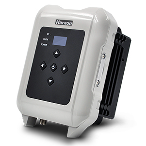
Harxon has introduced the smart eRadio, a member of its radio modem series. The eRadio is a long-range and power-efficient solution designed to support high-precision GNSS real-time kinematic (RTK) applications in surveying and precision agriculture.
Harxon eRadio is enabled with intelligent serial baud rate identification for different RTK devices. It can automatically identify RTK serial baud rate with a radio data cable and provide a plug-and-play form for easy connection between the eRadio and RTK, the company said.
Photo: Harxon
Due to its high transmitting power (5-35 Watts), transmission data can be up to 19200 bps/s over a connection distance of 50-80 kilometers, depending on the environment.
The eRadio offers surveyors an easy-to-use radio modem that provides dependable performance as either a base or repeater working with other Harxon radio modems in challenging environments. In the store and forward operating mode, eRadio receives messages, buffers the received data and transmits further to another substation.
The user programmable eRadio also supports the Bluetooth of APP to configure data and update radio status. Its diagnostic reporting software can realize the built-in reliability monitoring, such as internal temperature, environment status and battery level and channel inspection. According to the company, these features allow users to both anticipate and deal with potential issues efficiently.
In addition to compatibility with radio protocols by Trimble and Satel, eRadio is equipped with its unique ETALK communication protocol, which uses Harxon’s exclusive algorithms and advanced processors. Under the same conditions, ETALK protocol can significantly reduce the bit error rate of weak signals and the communication distance can be increased by 20 percent.
The compact, rugged eRadio is particularly well suited for heavy-duty outdoor use. It is designed for easy mobile use with an organic light-emitting diode display screen for demanding field conditions. The IP67 full metal cover provides dust and water resistance that keeps surveyors working with confidence and efficiency.
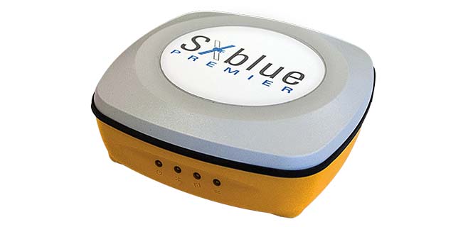
Geneq has launched the SXblue Premier GNSS receiver, which is available in a submetric version (GNSS) or centimetric version (real-time kinematic, RTK).
The new SXblue Premier GNSS receiver is equipped with the Pacific Crest Maxwell 6 Trimble technology with BD910 (GNSS version) and BD930 (RTK version) OEM boards, delivering 220 channels to acquire and track GNSS signals from all constellations in view. It makes effective use of GPS, GLONASS, Galileo, BeiDou, QZSS and SBAS signals for outstanding highly precise positioning.
The SXblue Premier is small and light weight, and rugged for field work. It is equipped with dual mode for Bluetooth V2.1 and Bluetooth V4.0, ensuring the unit’s wireless communication with any Android or Windows terminal. With its two models, the user will have large efficiency and flexibility on the field either with SBAS corrections or RTK reference networks.
In addition, SXblue Premier can be configured for Wi-Fi hotspots, allowing users to connect and access a web management platform. It also can be used as a data link, providing a quick connection to the internet to receive corrections from reference station (CORS) networks so that it can process RTK measurements.
With its internal memory using an 8-GB solid state disk, SXblue Premier provides enough storage space for field data collection or raw data recording for a high data sampling rate.
Multiple compatible software programs — including FieldGenius, Carlson, Collector for ArcGIS — will meet the users’ diverse need, making SXblue Premier more powerful and flexible.
Positioning on a micro-scale is the task of a new sensor that reports on range of motion (ROM) achieved in stretching exercises and other post-operative activities by at-home patients after discharge from hospital. Telit, a company active in sensors for the Internet of Things (IoT), announced that U.K.-based 270 Vision Limited has selected Telit’s BlueMod+SR Bluetooth module for its BPMpro Mark 2 sensor for remote, precision measurement of patient ROM.
The BPS (Body Performance Measurement) wearable sensor is a medical device that measures patient ROM before and during rehabilitation. Post-surgery, patients are discharged to be remotely monitored at home as they undertake their daily routine using a BPMpro sensor. The captured sensor output displays on a patient tablet running BPMpathway software and streams live to the clinician, who can use this data to assess the patient’s progress. With the patient recovery data collected by BPMpathway, clinicians can tailor an orthopedic patient’s post-operative support to meet their individual needs, without having to wait for a face-to-face consultation.
The BlueMod+SR module is a very small form factor dual-mode Bluetooth 4.0 module (17 x 10 x 2.6 mm). Range in line of sight is about 100 meters. Dual mode means it supports classic Bluetooth basic rate (BR) and enhanced data rate (EDR) operations as well as Bluetooth low energy (LE).
New app promises better-than-GPS urban guiding
Attention, GPS World readers living in or visiting Central London, Mountain View, California or San Francisco. Public beta of a new app (iOS only) will take you by the hand — er, phone — and lead you around the fair city; those cities only, at present. More intriguing, it claims to deliver “better than GPS accuracy.”
This augmented reality (AR) navigation employs an AR-native framework, Apple’s ARKit. Blippar touts its AR City app for something it calls “urban visual positioning…which localizes users with higher accuracy than GPS, thanks to computer vision.” The app uses visual inertial odometry, interpreting movement seen through the camera, to minimize position errors, that is, in a sense, to correct GPS.
Holding the phone in front of one’s face in tourist fashion, the user receives nearby points of interest based on what he or she can actually see. The app feature three layers of information:
AR Basic Navigation. A visualization of walking routes through augmented reality.
Enhanced Map Content. Overlays of information and content related to user location in AR — for example, streets and points of interest.
Urban Visual Positioning. Recognition, positioning and directional information via computer vision.
AR basic navigation, available everywhere that is supported by Apple Maps, visualizes routes with arrows shown in augmented reality. AR basic navigation uses GPS to estimate the absolute position of the user, and visual inertial odometry (VIO) to track their local movement. Blippar integrates GPS and VIO by building on the ARCL library, which uses Apple’s ARKit for VIO and Core Location for GPS.
GPS alone doesn’t give a high enough level of accuracy when looking at the map and has an average error rate of 16 m in cities, according to Blippar, which claims its urban visual positioning provides more than twice its accuracy.
Integrations of MEMS sensors with signal conditioning and radio communications form “motes” with extremely low-cost and low-power requirements and miniaturized form factor. Now standard features in modern mobile devices, MEMS accelerometers and gyros can be combined with absolute positioning technologies, such as GNSS or other wireless technologies, for user localization.
Navigation has been revolutionized by micro-electro-mechanical systems (MEMS) sensor development, offering new capabilities for wireless positioning technologies and their integration into modern smartphones.
These new technologies range from simple IrDA using infrared light for short-range, point-to-point communications, to wireless personal area network (WPAN) for short range, point-to multi-point communications, such as Bluetooth and ZigBee, to mid-range, multi-hop wireless local area network (WLAN, also known as wireless fidelity or Wi-Fi), to long-distance cellular phone systems, such as GSM/GPRS and CDMA.
With these technologies, navigation itself has become much broader than just providing a solution to location-based services (LBS) questions, such as “Where am I?” or “How to get from start point to destination?”
It has moved into new areas such as games, geolocation, mobile mapping, virtual reality, tracking, health monitoring and context awareness.
MEMS sensors are now essential components of modern smartphones and tablets. Miniaturized devices and structures produced with micro-fabrication techniques, their physical dimensions range from less than 1 micrometer (μm, a millionth of a meter) to several millimeters (mm).
The types of MEMS devices vary from relatively simple structures having no moving elements to complex electromechanical systems with multiple moving elements under the control of integrated microelectronics.
Apart from size reduction, MEMS technology offers other benefits such as batch production and cost reduction, power (voltage) reduction, ruggedization and design flexibility, within limits.
Wireless sensor technology allows MEMS sensors to be integrated with signal-conditioning and radio units to form “motes” with extremely low cost, small size and low power requirements.
New miniaturized sensors and actuators based on MEMS are available on the market or in the development stage.
Today’s smartphone sensors can include MEMS-based accelerometers, microphones, gyroscopes, temperature and humidity sensors, light sensors, proximity and touch sensors, image sensors, magnetometers, barometric pressure sensors and capacitive fingerprint sensors, all integrated to wireless sensor nodes.
These sensors were not initially intended for navigation. For instance, accelerometers are used primarily for applications such as switching the display from landscape to portrait as well as gaming.
These embedded sensors, however, are natural candidates for sensing user context. Because of their locating capabilities, people are getting used to the location-enabled life.
MEMS accelerometers and gyros, for instance, can be employed for localization in combination with absolute positioning technologies, such as GNSS or other wireless technologies.
WIRELESS OPTIONS IN SMARTPHONES
Various wireless standards have been established. Among them, the standards for Wi-Fi, IEEE 802.11b and wireless PAN, IEEE 802.15.1 (Bluetooth) and IEEE 802.15.4 (ZigBee) are used more widely for measurement and automation applications.
All these standards use the instrumentation, scientific and medical (ISM) radio bands, including the sub-GHz bands of 902–928 MHz (US), 868–870 MHz (Europe), 433.05–434.79 MHz (US and Europe) and 314–316 MHz (Japan) and the GHz bands of 2.4000-2.4835 GHz (worldwide acceptable).
In general, a lower frequency allows a longer transmission range and a stronger capability to penetrate through walls and glass.
However, due to the fact that radio waves with lower frequencies are more easily absorbed by materials, such as water and trees, and that radio waves with higher frequencies are easier to scatter, effective transmission distance for signals carried by a high-frequency radio wave may not necessarily be shorter than that of a lower frequency carrier at the same power rating.
The 2.4-GHz band has a wider bandwidth that allows more channels and frequency hopping and permits compact antennas.
Wireless Fidelity. Wi-Fi (IEEE 802.11) is a flexible data communication protocol implemented to extend or substitute for a wired local area network, such as Ethernet. The bandwidth of 802.11b is 11 Mbits and it operates at 2.4 GHz frequency.
Originally a technology for short-range wireless data communication, it is typically deployed as an ad-hoc network in a hot-spot. Wireless networks are built by attaching an access point (AP) to the edge of a wired network.
Clients communicate with the AP using a wireless network adapter similar to an Ethernet adapter. Beacon frames are transmitted in IEEE 802.11 Wi-Fi for network identification, broadcasting network capabilities, synchronization and other control and management purposes.
Timers of all terminals are synchronized to the AP clock by the timestamp information of the beacon frames. The IEEE 802.11 MAC (Media Access Control) protocol utilizes carrier sensing contention based on energy detection or signal quality.
RSSs and MAC addresses of the APs are location-dependent information that can be adopted for positioning. For localization of a mobile device, either cell-based solutions or (tri)lateration and location fingerprinting are commonly employed.
Bluetooth. A wireless protocol for short-range communication, Bluetooth (IEEE 802.15.1) uses the 2.4-Hz, 915-MHz and 868-MHz ISM radio bands to communicate at 1 Mbit between up to eight devices. It is mainly designed to maximize the ad-hoc networking functionality (Wang et al., 2006).
Compared to Wi-Fi, the gross bit rate is lower (1 Mbps), and the range is shorter (typically around 10 m). On the other hand, Bluetooth is a “lighter” standard, highly ubiquitous (embedded in most phones) and supports several other networking services in addition to IP. For positioning either tags (small size transceivers) or Bluetooth low energy (BLE) iBeacons are common.
Each tag has a unique ID that can be used for localization. iBeacon is a low-energy protocol developed by Apple; compatible hardware transmitters, typically so-called beacons, broadcast their identifier to nearby portable electronic devices.
The technology enables smartphones, tablets and other devices to perform actions when in close proximity to an iBeacon whereby a universally unique identifier picked up by a compatible app or operating system is transmitted.
The identifier and several bytes sent with it can be used to determine the device’s physical location, track customers, or trigger an LBS action on the device such as a check-in on social media or a push notification.
One application is distributing messages at a specific point of interest — for example, a store, a bus stop, a room or a more specific location like a piece of furniture or a vending machine. This is similar to previously used geopush technology based on GNSS, but with a much reduced impact on battery life and much extended precision.
Another application is an indoor positioning system, which helps smartphones determine their approximate location or context. With the help of an iBeacon, a smartphone’s software can approximately find its relative location to an iBeacon.
iBeacon differs from some other LBS technologies as the broadcasting device (beacon) is only a one-way transmitter to the receiving smartphone, and necessitates a specific app installed on the device to interact with the beacons.
This ensures that only the installed app (not the iBeacon transmitter) can track users, potentially against their will, as they passively walk around the transmitters. Localization is based on proximity sensing and cell-based solutions.
ZigBee. ZigBee is an IEEE 802.15.4-based specification for a suite of high-level communication protocols used to create personal area networks with small, low-power digital radios.
ZigBee operates in the ISM radio bands: 2.4 GHz in most jurisdictions worldwide, 784 MHz in China, 868 MHz in Europe and 915 MHz in the U.S. and Australia. Data rates vary from 20 kbit/s (868-MHz band) to 250 kbit/s (2.4-GHz band).
It adds network, security and application software and is intended to be simpler and less expensive than other WPANs such as Bluetooth or Wi-Fi.
Owing to its low power consumption and simple networking configuration, ZigBee is best suited for intermittent data transmissions from a sensor or input device.
Applications include wireless light switches, electrical meters with in-home displays, traffic management systems and other consumer and industrial equipment that requires short-range low-rate wireless data transfer.
Distances are limited to 10–100 m line-of-sight, depending on power output and environmental characteristics. ZigBee localization techniques usually use measurement of signal strength (RSS-based positioning) in conjunction with (tri)lateration and fingerprinting.
COMPARING STANDARDS
Table 1 compares the three wireless standards most suitable for a wireless sensor network. The standards also address the network issues for wireless sensors. Three types of networks (star, hybrid and mesh) have been developed and standardized.
TABLE 1. Comparison of Wi-Fi, Bluetooth and ZigBee.
Bluetooth uses star networks, composed of piconets and scatternets. Each piconet connects one master node with up to seven slave nodes, whereas each scatternet connects multiple piconets, to form an ad-hoc network. ZigBee uses hybrid star networks of multiple master nodes with routing capabilities to connect slave nodes, which have no routing capability.
The most efficient networking technology uses peer-to-peer mesh networks, which allow all the nodes in the network to have routing capability. Mesh networks allow autonomous nodes to self-assemble into the network and allow sensor information to propagate across the network with high reliability and over an extended range.
They also allow time synchronization and low power consumption for the “listeners” in the network, thus extending battery life. When a large number of wireless sensors need to be networked, several levels of networking may be combined.
For example, an IEEE 802.11 (Wi-Fi) mesh network comprised of high-end nodes, such as gateway units, can be overlaid on a ZigBee sensor network to maintain a high level of network performance.
A remote application server (RAS) can also be deployed in the field close to a localized sensor network to manage the network, to collect localized data, to host web-based applications, to remotely access the cellular network via a GSM/GPRS or a CDMA-based modem and, in turn, to access the internet and remote users.
ESTIMATION METHODS
The three most common position estimation methods are cell-based positioning (cell-of-origin, CoO), (tri) lateration and location fingerprinting, regarding achievable positioning accuracies as well as their advantages and disadvantages.
They provide different level of accuracies ranging from dm up to tens of m. Compared to (tri)lateration and fingerprinting, the principle of operation of CoO is the most straightforward and simplest. Disadvantages range from the requirement of a large number of devices or receivers as well as their performance in dynamic environments.
All these techniques provide absolute localization capabilities. Their disadvantage is that position fixes are lost if no coverage or signal availability is available.
Thus, combination with other technologies to bridge loss of lock of wireless signals (for example, no GNSS reception) is required. In smartphones, motion sensors exists that can be employed for inertial navigation (IN). In this article, these sensors are also referred to as inertial sensors.
In the simplest case, a position solution can be obtained from the relative measurements of the inertial sensors via dead reckoning (DR). The accelerometers, for instance, can be used by a pedestrian to count steps while walking and the gyroscope and magnetometer can provide the direction of movement.
These sensors have therefore substantially won on importance for navigation solutions.
MEMS LOCATION SENSORS
For many navigation applications, improved accuracy and performance is not necessarily the most important issue, but meeting performance at reduced cost and size is.
In particular, small navigation sensor size allows the introduction of guidance, navigation and control into applications previously considered out of reach. In this context, the small size, extreme ruggedness and potential for very low-cost and weight means of MEMS gyros and accelerometers have been, and will be, able to utilize inertial guidance systems — a situation that was unthinkable before MEMS.
The reduction in size of the sensing elements, however, creates challenges for attaining good performance. In general, the performance of MEMS inertial measurement units (IMUs) continues to be limited by gyro performance, which is typically around 10 to 30 deg/h, rather than by accelerometer performance, which has demonstrated tens of micro-g or better.
MEMS has struggled to reach high-accuracy tactical-grade quality.
MEMS Accelerometors. MEMS accelerometers are either pendulous/displacement mass type or resonator type. The former use closed-loop capacitive sensing and electrostatic forcing while the latter are based on resonance operation.
Both can detect acceleration in two primary ways: either displacement of a hinged or flexure-supported proof mass under acceleration, producing a change in a capacitive or piezoelectric readout, or frequency change of a vibrating element caused by a change in its tension induced by a change of loading from a seismic-proof mass.
Pendulous types can meet a wide performance range from 1 mg for tactical systems down to 25 μg. Resonant accelerometers or VBAs can reach higher performance down to 1 μg.
MEMS-Based Gyroscopes. For MEMS INS, attaining suitable gyro performance is more difficult to achieve than accelerometer performance. Fundamentally, MEMS gyros fall into four major areas: vibrating beams, vibrating plates, ring resonators and dithered accelerometers.
Gyroscopes are usually built as hybrid solutions, with sensor and electronics as two separate chips. The operational principle for all vibratory gyroscopes is based on the utilization of the Coriolis force.
If a mass is vibrated sinusoidally in a plane, and that plane is rotated at some angular rate Ω, then the Coriolis force causes the mass to vibrate sinusoidally perpendicular to the frame with amplitude proportional to the angular rate Ω.
Measurement of the Coriolis-induced motion provides knowledge of the angular rate Ω. This rate measurement is the underlying principle of all quartz and silicon micro-machined.
These gyroscopes are usually designed as an electronically driven resonator, which are often fabricated out of a single piece of quartz or silicon. The output is demodulated, amplified and digitized. Their extremely small size, combined with the strength of silicon, makes them ideal for very high-acceleration applications.
For purely surface micro-mechanical gyroscopes, given their small sizes and capacitances, monolithic integration is an option to be considered not so much for cost as for performance.
Combined IMUs. Further interest in all-accelerometer systems, which are also referred to as gyro-free, arises because high-performing small gyroscopes are very difficult to produce. Two approaches are typically used. In the first, the Coriolis effect is utilized.
Typically, three opposing pairs of monolithic MEMS accelerometers are dithered on a vibrating structure (or rotated). This approach allows the detection of the angular rate Ω. In the second, the accelerometers are placed in fixed locations and used to measure angular acceleration.
In both approaches, the accelerometers also measure linear acceleration, enabling a full navigation solution. In the direct approach, however, the need to make one more integration step makes it more vulnerable to bias variations and noise, so the output errors grow by an order of magnitude faster over time than when using a conventional IMU.
However, these devices only provide tactical-grade performance, and are most useful in GNSS-aided applications. The concept of a navigation-grade all-accelerometer IMU requires accelerometers with accuracies on the order of nano-g’s or better, and with large separation distances.
Use of all-accelerometer navigation for GNSS-unavailable environments will likely require augmentation with other absolute positioning techniques. Further sensor size reductions are underway through the combination of two in-plane (x- and y-axis) and one out-of- plane (z-axis) sensors on one chip. These multi-axes gyroscopes and accelerometer chips produce IMUs as small as 0.2 cm3.
Barometric Sensors. Barometric pressure sensors embedded in smartphones and other mobile devices demand small size, low cost and high-accuracy performance. The key element of a pressure sensor is a diaphragm containing piezoresistors which can be formed by ion implantation or in-diffusion.
Applied pressure deflects the diaphragm and thereby changes the resistance of the piezoresistors. By arranging the piezoresistors in a Wheatstone bridge, an output signal voltage can be generated. The measurement sensitivity of the pressure sensor is determined by the strain at the bottom plane of the diaphragm, whereby larger strain leads to higher sensitivity.
These altimeters are increasingly used in smartphones and other navigation systems. They can enable altitude determination of the user, for example, to determine the correct floor in a multi-storey building.
Pedestrian Dead Reckoning (PDR). The MEMS accelerometers embedded in the mobile device can be used to estimate the distance traveled from the accelerations made while walking, and magnetometers and gyroscopes to obtain user heading. Starting from a known position, determined by GNSS or other absolute positioning technique, the current position of the user can then be dead-reckoned using observations of the inertial sensors.
DR techniques differ from other localization techniques because the position is always calculated relative to the previously calculated position and no correlation with the real position can be made. PDR can give the best available information on position; however, it is subject to significant cumulative errors, i.e., either compounding, multiplicatively or exponentially, due to many factors as both velocity and direction must be accurately known at all instants for position to be determined accurately.
The accuracy of PDR can be increased significantly by using other, more reliable methods — GNSS or another absolute positioning technique such as Wi-Fi — the combination with inertial sensors produces more reliable and accurate navigation.
Altitude Determination. For navigation, determination of the altitude of the user can be of great importance, for example in determining the correct floor in a multi-storey building. Barometric pressure sensors can provide this data, augmenting the inertial sensors that can usually only provide reliable 2D localization.
Furthermore, if only three GNSS satellites are visible, providing a 2D positioning solution, pressure sensors can aid 3D localization.
Altitude determination with a barometric pressure sensor can be performed relatively from a given start height — for example, obtained from GNSS outside the building or from a known height point in the indoor environment.
As the user walks inside the building and up stairs or elevator to other floors, differences in air pressure can be calculated using a simple relationship between the pressure changes and height differences.
For conversion of the air pressure in a height difference, the mean value of the temperature at both stations is also required; MEMS infrared temperature sensors are increasingly found in smartphones to provide this.
Activity Detection. Low-cost inertial and motion sensors provide a new platform for dynamic activity pattern inference. Human activity recognition aims to recognize the motion of a person from a series of observations of the user’s body and environment.
A single biaxial accelerometer can classify six activities: walking, running, sitting, walking upstairs, walking downstairs and standing.
Until recently, sensors on the body have been used for activity detection, and until recently only a few studies have used a smartphone to collect data for activity recognition.
Smartphone accelerometers recognize acceleration in three axes as shown in Figure 1. Different motion sequences can thereby be ascertained.
Figure 1. Smartphone coordinate frame (left) and global horizontal coordinate system (right).
If a smartphone is held horizontally in the hand during a forward motion, then an acceleration in the y-axis is induced. When working with accelerations, two approaches can be applied to measure the linear displacement: integration of the accelerations or step detection combined with step size estimate.
In the first case, the distance traveled can be theoretically calculated by integrating the accelerations once for velocity, twice for distance.
Due to the double integration, however, any error in the signal will propagate rapidly, so the drift on the received signals from the accelerometer makes it impossible to use integration for walks of more than a few seconds.
The Zero Velocity Update (ZUPT) technique, where the velocity is reset to zero between every consecutive step when the foot is stationary for a small amount of time, can overcome this. Any error produced during one step has no influence on following steps. ZUPT can only be used when the accelerometer is placed on the foot, taking advantage of the stationary period between footsteps.
In the latter case, the distance traveled is obtained from step counts by processing the fluctuating vertical accelerations, which cross zero twice with every step. When the number of steps and the step size are acquired, the distance can be calculated by multiplication.
Figure 2 shows the recorded acceleration of a walking person in the z-axis, with significant maxima and minima that enable step-counting. Correction for the gravity effect on the x-, y- and z-axes of the smartphone’s local coordinate system is key to the correct determination of accelerometer-derived distance traveled. The MEMS-based three-axis accelerometer allows the device to detect the force applied along the three axes in order to accomplish specific functions based on predefined configurations.
Figure 2 . Typical recording of accelerometer sensor data in z-axis of a walking user.
The mobile device can be oriented in such that one of the axes is aligned in the direction of movement or heading (for example, y-axis), the positive x-axis is pointing rightward and the positive z-axis is upward (compare Figure 1). When the y-axis is horizontal, the gravity effect will be fully reflected on the z-axis.
However, a cell phone will most likely be placed by a user into a pocket or bag. Therefore, most existing step detection algorithms cannot be used directly — adjustments have to be made to take into account the orientation of the accelerometers. Because a phone can be placed with any side up or down, the accelerations are observed to determine which axis is the most vertical one.
The accelerations of the axis that is pointing directly to the center of the Earth has a value of 1 g due to gravity. So if the smartphone is lying flat on a table, with the display side up, then the z-axis of the accelerometer would theoretically have a value of 1,000 mg.
If the phone is put crooked (not along one of the axes) in someone’s pocket, the values will be lower than 1,000 mg. So to detect which accelerometer has the most vertical axis, the absolute average of the last 30 samples, or 1.2 seconds, of all three axes of the accelerometers of which the absolute value is closest to 1 g, is the most vertical axis and the accelerometer to use.
SYSTEM COMPARISON
Table 2 compares the most commonly used location sensors and systems in mobile devices classified depending on their positioning capability — absolute or relative — and on their type. A meaningful combination in form of a hybrid solution will produce the best performance for localization of a mobile smartphone user.
TABLE 2. Specifications of the most commonly used location sensors and systems in mobile devices.
Combining MEMS, Wireless. For the majority of indoor navigation systems, the combination of MEMS sensors and wireless options provides the optimal solution. MEMS sensors can provide relative positioning information, with an unbounded accumulation of location errors over time. Wireless systems provide an absolute position in either a local or global coordinate frame, independent of previous estimates without integrating measurements over time. The combination of these two technologies takes advantages of the strengths of both, producing a more robust position solution.
CONCLUSIONS
The increasing ubiquity of location-aware devices has pushed the need for robust GNSS-like positioning capabilities in difficult environments.
No single sensor or technique can meet the positioning requirements for the increasing number of safety- and liability-critical mass-market applications.
Integration is one approach to improving performance level, but a significant step change in high-performance positioning in GNSS-difficult environments, higher performance level are required from MEMS and wireless technologies.
ALLISON KEALY is a professor of geospatial science at Royal Melbourne Institute of Technolgy University, Australia. She holds a Ph.D. in GPS and geodesy from the University of Newcastle upon Tyne, UK. He is co-chair of FIG Working Group 5.5. Ubiquitous Positioning and vice president of the International Association of Geodesy (IAG) Commission 4: Positioning and Applications.
GÜNTHER RETSCHER is associate professor in geodesy and geoinformation at the Vienna University of Technology, with a Ph.D. in applied geodesy. He is co-chair of IAG Sub-Commission 4.1 on Emerging Positioning Technologies and GNSS Augmentation and of the IAG/Fig Working Group on Multi-Sensor Systems.
Geneq has introduced the SXblue Platinum, the latest model in the SXblue series. This high-accuracy GNSS receiver is compatible with iOS, Windows and Android Bluetooth, and provides real-time professional-grade positioning information.
Powered by 394 channels, the SXblue Platinum uses all constellations (GPS, GLONASS, Galileo, BeiDou and QZSS) with triple frequency, and provides the ability to use global or local coverage for corrections (SBAS, L-band and RTK).
With the scalable SXblue Platinum Basic, users can activate any frequency or constellation at anytime following initial purchase. The receiver is also field-upgradable, which means that these options can be remotely activated when convenient.
The Platinum was developed on the success of the proven SXblue receivers that were designed to optimize SBAS performances under tree canopy and in rugged terrain. In addition to location performances when working in a restricted environment, the SXblue Platinum is introducing an L-band signal correction via the Atlas service. This worldwide satellite-based correction system can deliver up to sub-decimeter accuracy. Thanks to its new Tracer technology, the receiver can sustain its level of accuracy when the Atlas signal is interrupted. The Atlas service can also stream data over the internet (NTRIP) while ensuring the best available vertical and horizontal accuracy.
Another innovative feature integrated on the Platinum model is the aRTK technology. This feature will allow RTK corrections to be received via the Atlas service, when RTK corrections have not been received for a period of time. For an Atlas-subscribed user device, a high accuracy will still be available at the subscribed service level until RTK is restored.
The new receiver is the same compact, lightweight, palm-sized unit as the SXblue series, which is completely dustproof and ruggedized. The internal, rechargeable, field-replaceable Li-Ion battery has on-board LEDs for easy access to battery life information.
The SXblue Platinum is targeted at GPS/GIS mapping and survey professionals in industries such as forestry, utilities, agriculture, environmental and other natural resource industries in addition to local, state and federal government users.
With a wide variety of compatible software and mobile devices, the support team can help users choose the perfect solution for their applications. A free iOS application for NTRIP/DIP configuration, named iSXblue RTN, is available from the App Store.
Telit has launched BlueMod+S42M, a Bluetooth low-energy (BLE) 4.2, standalone, single-mode module with embedded 3-axis accelerometer, temperature and humidity sensors.
The cost-effective component is optimized for efficiency and simplicity in end-device design and manufacturing, delivering reliable BLE functionality with robust endpoint security, motion and environmental sensors and essential features that reduce development costs, bill of materials, and time to market.
Designed for large-scale projects, the BlueMod+S42M expedites device design across a wide range of industrial and consumer applications areas, the company said. The embedded sensors are for high-value, fragile asset tracking, and time- or temperature-sensitive applications such as cold chain monitoring in the pharmaceutical and agriculture industries.
The release of the certified BlueMod+S42M complements the Telit portfolio of Bluetooth and BLE modules and directly addresses the demand in the rapidly growing BLE-dependent market. A report released by IndustryARC Analysis, forecasts Bluetooth Low Energy enabled devices shipments to increase to 8.4 billion units by 2020 at a CAGR of 29 percent.
“Cost, power, and reliability are critical to the success of IoT applications that demand efficient BLE solutions,” said Ronen Ben-Hamou, Telit EVP of products and solutions. “Our new qualified Bluetooth module caters to designers of all levels with tight development, materials and manufacturing cost constraints and even tighter timelines. The beauty of the +S42M is it’s simplicity: single-chip SoC (system on chip), feature packed, sensibly priced, exceptional power savings and extensive interoperability.”
Full applications can be embedded in the BlueMod+S42M, which is a self-contained SoC requiring no additional external supporting components. It is equipped with an on-board micro controller, integrated chip antenna, passive components, T°/Humidity sensor, and an accelerometer.
Leveraging a rich subset of features from Telit’s diverse family of BlueMod+Sx modules, including a GATT interface and terminal I/O profile combination, the new BlueMod+S42M greatly simplifies and accelerates the development of applications, Telit said.
In addition to efficient performance and low power consumption, BlueMod+S42M includes value-added features that further streamline development:
Bluetooth v4.2 Qualified Module
RED, SRCC Certified
Generic GATT Client and Server
LE Secure Connections
Configurable DIS (Device Information Service)
LE Data Length Extension
Terminal I/O for Easy Transparent Data Transfer (BLE- SPP like)
Embedded Sensors
Over-the-Air Updates
Sample Code for iOS and Android
WeChat Air Sync Protocol
Designers using the BlueMod+S42M have access to comprehensive development and integration tools including evaluation and development kits.
Visit Telit at the Sensors Expo in San Jose, California, June 27-29, booth 1244.
Fathom, a Bluetooth real-time location system (RTLS) asset tracking company, has signed an agreement with Gimbal, a manufacturer for enterprise-grade mobile engagement and location intelligence.
The partnership presents customers with the combined strengths of each company: Gimbal’s reliable beacons and over-the-air security and Fathom’s high-accuracy indoor location platform, the companies said in a joint press release.
The agreement includes joint marketing and sales referrals to common prospective enterprise customers. It also enables Fathom to distribute Gimbal beacons and leverage Gimbal Secure Mode functionality.
“With Fathom to monitor and locate their beacons, both existing and new Gimbal deployments will enjoy the best each company offers,” said Fathom CEO Guylain Roy-MacHabée. “We are building a partner ecosystem with the best global beacon vendors and we are proud to work with Gimbal. Fathom’s asset tracking customers can now purchase Gimbal beacons directly from us, including the popular coin-sized Gimbal S10 — an ideal form factor that enables exciting and secure asset tracking scenarios.”
Fathom offers next-generation indoor location technology, utilizing Bluetooth to enhance asset tracking systems. Fathom complements asset tracking systems by providing greater coverage than RFID, greater accuracy than Wi-Fi and at a lower cost than other real-time location systems like ultra-wideband (UWB).
“Fathom’s location expertise and ability to accurately locate beacons indoors without the need for a mobile app is a natural fit for the asset tracking market,” said Brian Dunphy, general manager for Gimbal’s enterprise business. “We are delighted to be working with Fathom to expand the reach of each other’s products in the marketplace.”
Gimbal harnesses the power of location and proximity to drive value and create personalized experiences for customers, using location-specific events, geofences and beacons to access deep data analytics via a sophisticated location management platform.
Asteri Navigation will introduce a new line of rugged, compact and fully integrated GNSS receivers on Nov. 15 at the 2016 Autodesk University in Las Vegas, Nevada.
Suitable for geospatial field data collection and inspection applications that require high accuracy positioning, the Asteri X-Series receivers are light enough to be mounted to external sensors or worn on the body or arm.
Asteri Navigation will debut the affordable X-1 and X-2 receivers in booth No. 1783 at Autodesk University, which runs from Nov. 15-17 at The Venetian in Las Vegas. The X-3 is scheduled for release in December.
The compact Asteri receivers were designed with safety and ease of use in mind. Each device weighs just 11.3 ounces with the 12-hour lithium battery. Their 2.8-inch by 5.4-inch size allows them to fit safely in shoulder or arm pouches.
The internal single-frequency antenna enables users to capture accuracies of well under 10 centimeters with RTK/VRS corrections. This integrated design allows users to work in difficult terrain without worrying about equipment and antennas getting snagged or broken.
Engineered to provide centimeter-level accuracy with Real-Time Kinematic (RTK) or Virtual Reference Station (CRS) correction when connected to an external antenna, the Asteri GNSS receivers support a generic NMEA 0183 GNSS data protocol. This makes them compatible with data collection and field mapping applications supporting the same protocol and ideal for users who want to develop their own software applications for inspection and GIS data capture activities.
The new receivers can communicate via Bluetooth or cable with most popular devices used for field data collection, including utility line locators, ground penetrating radar, data loggers, laser rangefinders, smartphones, and tablets.
Asteri expects the X-Series will be used extensively in mapping and survey applications related to asset management, pipeline operation, utility construction, forestry, electric staking, and underground utility location.
For users needing higher accuracy, an external multi-frequency antenna can be added to the provided port on the receiver. In addition, the Asteri X-3 will be compatible with Atlas GNSS satellite-based real-time correction services worldwide.
The three products in the X-Series provide varying levels of accuracy:
X-1 provides sub-meter accuracy out of the box.
X-2 offers accuracy of 1 meter down to 1 centimeter with RTK/VRS.
X-3 will achieve 1 centimeter with RTK/VRS, 30 centimeters with Atlas H30, 4-10 centimeters with Atlas H10.
u-blox has announced ARM mbed OS 5 support for the ODIN-W2 wireless Internet of Things (IoT) gateway module and the NINA-B1 Bluetooth low energy module.
The ARM mbed OS 5 incorporates a real-time operating system (RTOS) in the core of the operating system. This open environment provides all the features needed to rapidly deploy and develop connected IoT products based on an ARM Cortex-M microcontroller, including security, connectivity and drivers for sensors and I/O devices. On existing u-blox ODIN-W2 and NINA-B1 hardware, customers can now rapidly develop wireless IoT applications making it easier to cut costs, development time and footprint, the company.
At ARM TechCon, held Oct. 26-27 in Santa Clara, California, u-blox will showcase the NINA-B1 and ODIN-W2 in a powerful and responsive IoT sensor-to-gateway-to-cloud scenario. In the live demonstration, the ODIN-W2 will read sensor data via Bluetooth low energy technology from NINA-B1-equipped sensors, and simultaneously stream it via Wi-Fi to an IBM cloud server, allowing for real-time data visualization and analysis.
“The unique combination of u-blox’s ODIN-W2 and NINA-B1 with ARM mbed OS 5 creates the best performing complete IoT architecture solution for applications from sensor data collection to flexible intelligent gateway processing and cloud connectivity, with full support for customer code — all based on the most proven embedded application platform,” said Hakan Svegerud, head of Product Strategy, Short Range Radio, at u-blox.
The already certified ODIN-W2, NINA-B1 and wireless stacks are designed for typical embedded applications, which require a small footprint implementation with responsive, high-performance hardware and an open CPU architecture. Usage scenarios include IoT, and medical and industrial applications, that use multiple sensors and/or smart gateways linked by Wi-Fi and Bluetooth. ODIN-W2’s 1-MB of flash memory offers ample space for all the customer software required to create a powerful gateway.
The ARM mbed development environment, with its extensive tools and libraries, gives embedded application designers and developers full access to each u-blox module’s ARM Cortex-M4 based microcontroller. This allows them to avoid the need for an external host CPU — not only saving bill of materials costs and development resources, but also keeping the board footprint to an absolute minimum.
In addition to providing a consistent development process across multiple products, this environment allows an extremely broad range of sensor and actuator-based IoT designs to be implemented on a single, compact, certified wireless module. Moreover, the u-blox open standard approach ensures ease of IoT connectivity, while still accelerating type approval certification by controlling access to the wireless stacks. All of these advantages combine to reduce time to market to a minimum.
Eos Positioning Systems has announced its most advanced high-accuracy Bluetooth GNSS receiver, the Arrow Gold. The Arrow Gold is the first high-accuracy iOS, Android and Windows Bluetooth GNSS receiver to implement all four constellations (GPS, GLONASS, Galileo, BeiDou), three frequencies (L1, L2, L5) and satellite-assisted RTK.
The Arrow Gold provides 1-cm real-time accuracy in more places, and on all iOS, Android, and Windows devices. The palm-sized Arrow Gold works with any data-collection app designed for iOS, Android or Windows, which means that apps like Esri Collector, Esri ArcPad, Survey123 and others work with Arrow Gold right out of the box.
The Arrow Gold introduces an innovative RTK feature for poor cellphone coverage areas — SafeRTK. The SafeRTK feature uses satellite corrections to fill in when the user’s RTK network connection is lost. Even in populated urban areas, wireless connectivity has dead spots. For traditional RTK receivers, this is a deal-breaker. For the Arrow Gold, SafeRTK takes over when wireless coverage fails, allowing users to continue working with centimeter accuracy for up to 20 minutes, free of charge.
Another pioneering feature of the Arrow Gold is 8-cm real-time accuracy anywhere in the world, at a revolutionary price point. On all iOS, Android and Windows devices, the Arrow Gold Basic delivers 8-cm real-time accuracy anywhere in the world using all four satellite constellations and the Atlas satellite correction service.
The Arrow Gold is built for tough environments. It is palm-sized, waterproof, dust-proof and weighs under one pound. It works in the rain, dust, dirt and in rugged environments. The user can mount the Arrow Gold on a range pole or slide it in a vest pocket. The Arrow Gold’s long-range, rock-solid Bluetooth radio stays connected to your mobile device up to 1,000 meters away, and it’s field-replaceable rechargeable battery pack lasts all day.
Owing to its support of all global satellite constellations (GPS, GLONASS, Galileo, BeiDou) and all planned satellite signals, the Arrow Gold will provide cutting-edge, high accuracy for the next decade, providing a return on investment (ROI) that will serve its users for years to come, Eos Positioning said. It doesn’t matter if user decides to switch from iOS to Android to Windows during the same project or years from now, the Arrow Gold has universal Bluetooth compatibility that supports all mobile devices for the forseeable future.
The Arrow Gold is targeted at high-accuracy applications such as GIS, environmental, agriculture, electric/gas/water/telecom utilities, surveying, machine control, and federal/state/local government.
Swedish-based survey and GIS equipment maker Satlab Geosolutions is offering a multi-purpose handheld that sends centimeter-level NMEA position data to the user’s tablet or smartphone.
The SLC RTK handheld brings professional high-precision positioning in a new design concept with Bluetooth connectivity for Android, Windows and iOS Bluetooth low-energy (BLE) smart devices, according to the company.
Alternatively, it can be used as a fixed sensor for any compatible NMEA driven positioning application.
The design includes a mounting plate to attach the user’s tablet device so it acts as the SLC’s display. Connectivity also is available via a USB/RS232 port. With a built-in wireless modem and optional remote antenna and pole- or fixed-mount accessories, the SLC can be configured as a sensor for machine control or other mobile applications.
SLC is flexible — it can be paired with data-collection software running on Windows, Android or iOS BLE with compatible applications. Its RTK positioning information can be used in numerous markets including land surveying, high-accuracy GIS, web-based facility management, utilities, pipelines, precise farming, hydrography, geophysics or aeronautics. With 32-GB internal memory, the SLC is also able to record RAW data to be used for post-processed applications.
The SLC has a built-in lithium ion battery and GNSS antenna for up to 12 hours of portable operation. It includes a Telit 3.5G GSM modem for operation as an RTK base or rover, transmitting or receiving corrections from NTRIP networks or via Satlab’s free Internet RTK service. Satlab Internet RTK allows users to stream corrections via IP to any of three Satlab servers around the world; any Satlab rover device can then connect to that same IP connection to receive full GNSS constellation corrections.
“Our new Scandinavian-designed SLC handheld is a different concept, offering RTK centimeter-level positioning at an incredible price in a flexible form factor,” commented Bjorn Agardh, CEO of Satlab. “With our simple SLC Toolbox software utility, users set up the SLC once, and it remains configured every time it’s used.”
The SLC comes in two configurations: as a handheld in a soft case with two tablet/panel mounting plates and a charging USB cable; or bundled with external geodetic antenna, cable and pole mount.
Geneq has introduced a new NTRIP client app for iOS that works with iSXBlue receivers.
iSXBlue RTN is used alongside other geospatial information systems (GIS) and surveying apps to obtain real-time centimeter accuracy on an iPhone or iPad.
Key features include real-time kinematic (RTK) alarm configurations with NTRIP and DIP modes. The easy-to-use app allows users to update their receiver with the latest firmware, the company said.
Other features include real-time map location with accuracy and satellite skyplot for GPS, GLONASS and SBAS. The app supports all current and future constellations such as BeiDou and Galileo, the company said.iSXBlue and SXBlue GPS Receiver users include GIS and surveying professionals in industries such as agriculture, environmental, government, mining, natural resources, surveying and utilities.