Tag: California

  • Amazon to start drone delivery service in California

    Amazon to start drone delivery service in California

    Photo: Amazon
    Photo: Amazon

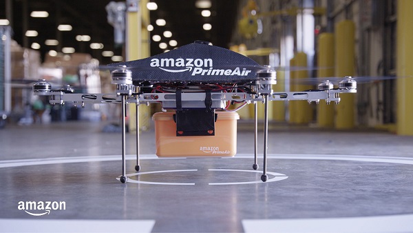
    Amazon customers in Lockeford, California, will be among the first to receive Prime Air drone deliveries in the United States, later this year. According to an Amazon blog, the company has been working for almost a decade to make it a reality.

    Customers in Lockeford will see Prime Air-eligible items on Amazon. They will place an order as usual and receive an estimated arrival time with a status tracker for their order. For these deliveries, the drone will fly to the designated delivery location, descend to the customer’s backyard, and hover at a safe height. It will then safely release the package and rise back up to altitude.

    Customer feedback about Prime Air, with drones delivering packages in their backyards, will help Amazon create a service that will safely scale to meet the needs of customers everywhere, according to the company.

    “Lockeford residents will soon have access to one of the world’s leading delivery innovations,” said California State Assemblyman Heath Flora, whose district includes Lockeford. “It’s exciting that Amazon will be listening to the feedback of the San Joaquin County community to inform the future development of this technology.”

    “We are working with the Federal Aviation Administration (FAA) and local officials in Lockeford to obtain permission to conduct these deliveries and will continue with that collaboration into the future,” the blog said.

    Amazon designed its drones’ sense-and-avoid system for two main scenarios: to be safe when in transit, and to be safe when approaching the ground. Its algorithms use a diverse suite of technologies for object detection, enabling it to identify a static object in its path, such as a chimney. It can also detect moving objects on the horizon, such as other aircraft, even when it’s hard for people to see them.

    When obstacles are identified, the Amazon Prime drone will automatically change course to safely avoid them. As the drone descends to deliver a package into a customer’s backyard, it ensures that there’s a small area around the delivery location that is clear of  people, animals or other obstacles.

    Prime Air is one of three drone-delivery companies that has gone through the rigorous process to earn an FAA air carrier certificate, which will be required to operate drones using these advanced capabilities.

  • US West Coast now has access to GNSS-powered ShakeAlert app

    US West Coast now has access to GNSS-powered ShakeAlert app

    After 15 years of planning and development, the ShakeAlert earthquake early warning system is now available to more than 50 million people in California, Oregon and Washington, the most earthquake-prone region in the conterminous U.S.

    ShakeAlert provides alerts to the general public through public alert systems such as TV, radio and mobile phones. It also slows down trains, opens firehouse doors, closing water and gas valves and

    May’s addition of Washington State to the system completes the U.S. Geological Survey and partners’ West Coast rollout of ShakeAlert.

    ShakeAlert first launched in California in 2019 and expanded to Oregon in March of this year. People in all three states can now receive alerts from FEMA’s Wireless Emergency Alert system, third-party phone apps, and other technologies.

    The ShakeAlert system relies on sensor data from the USGS Advanced National Seismic System. ANSS is a USGS-facilitated collection of regional earthquake monitoring networks operated by partner universities and state geological surveys on the West Coast and throughout the nation.

    Part of that data comes from GPS, which the USGS uses to measure crustal deformations over time. The USGS measures the precise position (within 5 mm or less) of GNSS stations near active faults relative to each other.

    USGS works closely with ANSS partners and state emergency management agencies on the system’s development as well as public communication, education and outreach.  “USGS science is the backbone of hazard assessment, notification, and response capabilities for communities nationwide so they can plan for, and bounce back from, natural disasters,” said David Applegate, associate director for Natural Hazards Exercising the Delegated Authority of the USGS Director.


    See also:

    Early earthquake warnings: GNSS could enable 10-second alerts


    “Systems powered by ShakeAlert can turn mere seconds into opportunities for people to take life-saving protective actions or for applications to trigger automated actions that protect critical infrastructure,” Applegate said. “An effort like this takes the dedication, ingenuity and hard work of dozens of partners with the same vision, and the USGS is proud to have been part of a collaborative team that made this robust public safety system available for millions of citizens on the West Coast.”

    The ShakeAlert earthquake early warning system can save lives and reduce injuries by giving people time to take protective actions like drop, cover and hold on before potentially dangerous earthquake shaking arrives at their location.

    In addition to supporting public alerts to mobile phones, ShakeAlert system data has, since late 2018, been used to develop applications that trigger automated actions. Automatic actions can be used to slow down trains to prevent derailments, open firehouse doors so they don’t jam shut and close valves to protect water and gas systems.

    The technology will continue to improve over time with the addition of more seismometers to the network, by expanding alert delivery area and by improving messaging speeds.

    A GNSS station in the Pacific Northwest geodetic array. (Photo: Central Washington University)
    A GNSS station in the Pacific Northwest geodetic array. (Photo: Central Washington University)
  • A new angle on mapping cliffs on California’s shore

    A new angle on mapping cliffs on California’s shore

    Photo: Trimble
    Photo: Trimble

    Cliff surveys are traditionally performed with fixed-wing aircraft that collect nadir photos. However, a photogrammetry company accurately triangulated oblique images and mapped them in 3D stereo, developing a new technique in the process.

    The erosion survey — along Pacific Coast Highway 1 in Cayucos, California — required imaging the side of the cliff to produce a precise orthomosaic and topographic map of its structure and integrity. The project required a 0.5-inch orthomosaic, a 1.2-inch 3D topographic contour map and a vector-based digital terrain model accurate to 1.2 inches.

    Surveyor Paul Reichardt and Robert Lafica, owner of Central Coast Aerial Mapping, placed ground control points around the property and beach, and then used a Trimble R8 GNSS receiver to measure their positions to within 0.04-foot accuracy. They also established four checkpoints for quality control in the photo triangulation process. The R8 and a Trimble 5600 total station were used to collect property corners and top-of-surface elevations to integrate into the 3D topographic map.

    At an altitude of 131 feet, the UAS covered the site from both nadir and oblique camera angles in nine passes, collecting 158 photos at an average ground sample distance of 0.5 inches. To capture the cliff side, Lafica flew the UAS about 90 feet from its face and angled the camera at 40 degrees.

    The photos and position data were loaded into Trimble’s Inpho UASMaster photogrammetric software to automatically triangulate the images. The software pinpointed 6,368 common features with multiple connections to match images to each other. After initial triangulation, precise coordinates were attached to each control point, a final triangulation was completed to create the maps, and a new technique for mapping cliff faces was born.

  • GeoComm provides GIS for California’s Next Generation 9-1-1

    Photo: sturti/E+/Getty Images Plus
    Photo: sturti/E+/Getty Images Plus

    GIS company GeoComm is partnering with Atos Public Safety LLC on its contract with the State of California to transform the state’s 9-1-1 system.

    The upgrade will turn the state’s system to a broadband communication platform. The upgrade will give California — a state with a population of 40 million, more than many countries — the ability to intelligently route, manage and deliver a broad array of real-time information to 9-1-1, including text messages.

    The change also allows for an exchange of information within the 9-1-1 centers to reduce response time, enhance situational awareness and increase first responder safety.

    GeoComm, in partnership with Atos, will serve as the State of California’s statewide Next Generation 9-1-1 (NG9-1-1) GIS data services provider.

    Reliable and up-to-date GIS data is critical in NG9-1-1 to ensure accurate routing of 9-1-1 calls in an Emergency Services IP Network (ESInet). GeoComm’s public-safety GIS solution will power the underlying GIS data quality delivered through the Atos NG9-1-1 IP network and the regional networks as the authoritative NG9-1-1 GIS data for the state.

    In August 2019, Atos was awarded a five-year, $198 USD million contract with the State of California to transform the state’s 9-1-1 system to leading-edge broadband communication platforms that advance emergency services for the public, 9-1-1 professionals and first responders.

    “Access to a secure, reliable NG9-1-1 IP network will have a tremendous impact on the effectiveness of communications between emergency callers and first responder resources within communities,” said Phil Rotheram, Atos. “Atos Public Safety has been entrusted to migrate some of the world’s most mission-critical environments and we are happy to partner with GeoComm in the State of California for the critical statewide GIS element,”

    “GeoComm continues to be recognized throughout the country as the leader in NG9-1-1 GIS solutions and services,” said Erik Loberg, GeoComm vice president of product management. “We are honored to be working with Atos Public Safety LLC and the State of California for this exciting NG9-1-1 transformation project as the state migrates its 9-1-1 network, advancing emergency services for the public, 9-1-1 professionals, and first responders.”

  • Seen & Heard: Golf play, corn mazes and Google Maps

    Seen & Heard: Golf play, corn mazes and Google Maps

    “Seen & Heard” is a monthly feature of GPS World magazine, traveling the world to capture interesting and unusual news stories involving the GNSS/PNT industry.


    There’s an app for that

    For 17 years, Kersey Valley Attractions in Archdale, N.C., created its annual corn maze by using a GPS-enabled tractor to cut paths out of grown corn. Instead of being limited by a tractor’s turning radius, this year’s “Maize Adventure” used a GPS planter programmed with a maze design from the MazePlay app. Based in Idaho, MazePlay provides maze design and cutting services throughout North America. The Apollo 11 example here is from Richardson Adventure Farm in Spring Grove, Illinois.


    Photo: BMW
    Photo: BMW

    Just hit it already!

    To speed play, officials for the PGA European Tour are using a GPS tracking system. Tracking devices were placed on one golf bag in each group in the BMW Championship, held Sept. 19–22 in Surrey, UK. When a group completed a hole, the information was sent to officials and displayed at five holes. Next year, all 18 holes will have displays, which include player names and indicate if the group is behind. The tour plans to increase fines for pace-of-play violations.


    Photo: iStock.com/gchapel
    Photo: iStock.com/gchapel

    GPS makes it (too?) easy

    Animal rights groups are suing California over rules that allow animals to be hunted with the aid of hunting dogs wearing GPS tracking devices on their collars. The Animal Legal Defense Fund called the hunting method “unusually cruel and unfair” because tracking devices allow dogs to chase prey to the point of exhaustion, and then hunters follow the GPS signal to find an animal that can no longer flee and is easily shot. The lawsuit says the commission violated state environmental law by failing to conduct an assessment of how the use would affect wildlife.


    Photo: Google
    Photo: Google

    Google Maps come alive

    Google Maps is beta testing a new Live View feature, allowing travelers to use augmented reality (AR) to better see which way to go. Arrows and directions are placed in the real world to guide the walker. Google has tested Live View with its Local Guides and Pixel community for several months, and has now expanded the beta to Android and iOS devices that support ARCore and ARKit.

  • Seen & Heard: Microsatellites, tethered drones and ladybugs

    “Seen & Heard” is a monthly feature of GPS World magazine, traveling the world to capture interesting and unusual news stories involving the GNSS/PNT industry.

    Tethered drone

    Spanish police used a tethered drone system for traffic monitoring, crowd control and surveillance of the UEFA Champions League Final, played June 1 at the Wanda Metropolitano stadium in Madrid. An Elistair tethered U06 Plus drone oversaw 67,000 fans in the stadium and 200,000 in nearby streets. Use of the drone was in response to a heightened terrorist threat level in Spain, making it part of the largest security operation for any sporting event in the Spanish capital. Continuously supplied with power, the drone maintained its position at 50 meters high for 8 hours.

    CYGNSS satellite launch. (Artist’s concept/NASA)
    CYGNSS satellite launch. (Artist’s concept/NASA)

    Tricky Signals

    NASA’s eight CYGNSS (Cyclone Global Navigation Satellite System) microsatellites collect radio signals from GPS beacons to characterize hurricanes. A month after launch in December 2016, the CYGNSS team noticed the signals were wavering when the U.S. began to boost the radio power on 10 GPS satellites as they passed over northern Syria. The swings don’t interfere with other scientific uses of GPS, but for CYGNSS the measurements of high winds varied by 5 meters a second or more — the difference between a category-2 and category-3 hurricane. After two years of work, the CYGNSS team has compensated by repurposing a secondary antenna on the satellites to measure GPS signal strength.

    The ladybug blob tracked by Doppler radar. (Image: National Weather Service)
    The ladybug blob tracked by Doppler radar. (Image: National Weather Service)

    Ladybug, ladybug, fly away home

    In this case, California. In June, a millions-strong swarm of ladybugs showed up on radar as a weather event when the insects took to the sky to hunt for aphids. One explanation for the unusual swarm is that a large population of ladybugs had been spread out in a mountainous area, and rising temperatures triggered their mass migration to valleys where they might find an abundance of aphids to eat.

    New Zealand joins Aussies on SBAS

    Land Information New Zealand (LINZ) will work with Australian counterpart Geoscience Australia to investigate ways to deliver a regional satellite-based augmentation system (SBAS) to significantly improve GPS accuracy. The proposed SBAS will support emergency helicopter crews, providing pilots with accurate vertical guidance for landing, enabling them to reach people faster in difficult terrain and bad weather. The SBAS will also improve the safety of self-driving cars. The new system will improve accuracy to less than a meter, and in some devices to 10 centimeters.

  • California, Hawaii drone operators get shortcut to authorizations

    California, Hawaii drone operators get shortcut to authorizations

    Commercial drone operators in California and Hawaii — as well as a few areas in Nevada, Utah and Arizona — now can get quickly authorized to fly in controlled airspace, Skyward announced.

    Screenshot: Skyward
    Screenshot: Skyward

    Skyward is an FAA-approved airspace vendor. With Skyward, pilots can access the FAA’s LAANC (Low Altitude Airspace Notification Capability) across the five states.

    This means that pilots with a Part 107 license can get permission to fly in regulated airspace in seconds compared to manual authorizations that can take months, making it significantly easier for businesses of all sizes, particularly in the construction and warehousing industries, to manage a fleet of drones to access valuable, cost-saving data.

    The LAANC platform lets UAV operators take advantage of this digital timesaver. Skyward was the first provider approved by the FAA to offer LAANC, and Skyward saw quick adoption by its customers as soon as the prototype was released on Oct. 23, 2017.

    This phase of Skyward’s LAANC expansion includes airspace in some of the country’s busiest metro areas, including Los Angeles, the Bay Area, San Diego, Las Vegas and more than 50 smaller air markets. It will help the full diversity of businesses in the west find new ways to use drones in their operations through LAANC capability.

    Below is the full list of airspace covered in the latest rollout of LAANC (download a PDF, “The Complete Guide to the 2018 LAANC Rollout”).

    Los Angeles Air Route Traffic Control Center (ZLA)

    Blythe Airport (BLH), Blythe, CA

    Imperial County Airport (IPL), Imperial, CA

    Needles Airport (EED), Needles, CA

    St. George Regional Airport (SGU), St. George, UT

    Tonopah Airport (TPH), Tonopah, NV

    Jacqueline Cochran Regional Airport (TRM), Thermal, CA

    Meadows Field (BFL), Bakersfield, CA

    Chino Airport (CNO), Chino, CA

    McClellan–Palomar Airport (CRQ), Carlsbad, CA

    San Gabriel Valley Airport (EMT), El Monte, CA

    Grand Canyon National Park Airport (GCN), Grand Canyon Village, AZ

    Long Beach Airport (LGB), Long Beach, CA

    Montgomery – Gibbs Executive Airport (MYF), San Diego, CA

    Brackett Field (POC), La Verne, CA

    Palm Springs International Airport (PSP), Palm Springs, CA

    Gillespie Field (SEE), El Cajon, CA.

    Santa Monica Municipal Airport (SMO), Santa Monica, CA

    Zamperini Field (TOA), Torrance, CA

    North Las Vegas Airport (VGT), Las Vegas, NV

    Van Nuys Airport (VNY), Los Angeles, CA

    Hollywood Burbank Airport (BUR), Burbank, CA

    Ontario International Airport (ONT), Ontario, CA

    John Wayne Airport (SNA), Orange County, CA

    Santa Barbara Municipal Airport (SBA), Santa Barbara, CA

    Los Angeles International Airport (LAX), Los Angeles, CA

    San Diego International Airport (SAN), San Diego, CA

    McCarran International Airport (LAS), Paradise, NV

    Camarillo Airport (CMA), Camarillo, CA

    Oakland Air Route Traffic Control Center (ZOA)

    Eastern Sierra Regional Airport (BIH), Bishop, CA

    Mammoth Yosemite Airport (MMH), Mammoth Lakes, CA

    Paso Robles Municipal Airport (PRB), Paso Robles, CA

    Red Bluff Municipal Airport (RBL), Red Bluff, CA

    Lake Tahoe Airport (TVL), South Lake Tahoe, CA

    Ukiah Municipal Airport (UKI), Ukiah, CA

    Yuba County Airport (MYV), Olivehurst, CA

    Merced Regional Airport (MCE), Merced, CA

    Sacramento McClellan Airport (MCC), Sacramento, CA

    Reno-Tahoe International Airport (RNO), Reno, NV (already live)

    Fresno Yosemite International Airport (FAT), Fresno, CA

    Visalia Municipal Airport (VIS), Visalia, CA

    Napa County Airport (APC), Napa, CA

    Buchanan Field Airport (CCR), Concord, CA

    Hayward Executive Airport (HWD), Hayward, CA

    Livermore Municipal Airport (LVK), Livermore, CA

    Palo Alto Airport (PAO), Palo Alto, CA

    Reid–Hillview Airport (RHV), San Jose, CA

    Stockton Metropolitan Airport (SCK), Stockton, CA

    Charles M. Schulz–Sonoma County Airport (STS), Santa Rosa, CA

    Monterey Regional Airport (MRY), Monterey, CA

    Oakland International Airport (OAK), Oakland, CA

    Sacramento International Airport (SMF), Sacramento, CA,

    Norman Y. Mineta San José International Airport (SJC), San Jose, CA (already live)

    San Francisco International Airport, (SFO) San Francisco, CA

    Honolulu Area Control Facility (ZHN)

    Waimea-Kohala Airport (MUE), Kamuela, HI

    Lanai Airport (LNY), Lanai City, HI

    Hilo International Airport (ITO), Hilo, HI

    Kahului Airport (OGG), Kahului, HI

    Daniel K. Inouye International Airport (HNL), Honolulu, HI

  • HxGN SmartNet, AZGPS to expand GNSS correction services in US

    HxGN SmartNet has partnered with AZGPS LLC to expand access to quality network correction services for GNSS users in the southwestern United States.

    HxGN SmartNet, a high-precision, high-availability GNSS network correction service, is provided by Hexagon’s Geosystems division. AZGPS, based in Florence, Arizona, serves professionals across Southern California and Arizona who rely on high-precision GNSS with network correction services, professional support and training.

    The company will remain the local point of contact in the region and now has access to the infrastructure and resources of HxGN SmartNet, including HxGN SmartNet stations and a wide array of Hexagon services.

    “Our number-one goal is to help our customers succeed,” said Travis Thompson, AZGPS. “The ability to leverage the resources of HxGN SmartNet will enable AZGPS to provide even more benefits to GNSS users. We look forward to continuing the superior service our customers have come to rely on for more than 13 years while staying on the leading edge of technology.”

    HxGN SmartNet is fully open to all makes and models of GNSS equipment and is designed to provide the highest reliability and accuracy 24/7. Launched in 2010, HxGN SmartNet is a commercial GNSS network that offers a single connection point for coverage across North America.

    Built on the most advanced GNSS reference station software platform in the world, Leica Geosystems GNSS Spider, HxGN SmartNet provides high-precision, high availability network real-time kinematic (RTK) corrections for any application, the company said.

    A variety of different subscription plans are available at the state, regional and national level for any application requiring precision GNSS corrections. With more than 1,300 stations in 45 states and eight provinces, HxGN SmartNet North America offers extensive network coverage.

    “GNSS users across all applications know they can rely on HxGN SmartNet to make the investments and partnerships needed to provide the easiest, fastest and most precise positions in the industry,” said Wendy Watson, director of operations for HxGN SmartNet North America. “AZGPS has a long track record of providing excellent service to GNSS users in the Southwest through the AZGPS and CALVRS networks. This cooperation between two familiar names in the positioning services industry underscores HxGN SmartNet’s commitment to ‘any constellation, any application and open to all.’”

  • "Scariest commute of my life": California wildfires erupt

    Two fires erupted Monday in Southern California, fueled by strong Santa Ana winds. The Thomas fire in Ventura County started Monday night and has burned 45,000 acres and destroyed more than 150 structures. The Creek fire is burning near Sylmar and has prompted officials to evacuate more than 8,000 homes.

    Now a dramatic new wildfire erupted in Los Angeles early Wednesday. Flames exploded before dawn on the steep slopes of the Sepulveda Pass, which carries heavily traveled Interstate 405 through the Santa Monica Mountains where ridgetops are covered with expensive homes, including Bel Air. It is also the site of the Getty Center arts complex.

    More than a third of Ventura, California, residents have been forced from their homes. About 38,000 of the coastal city’s 100,000 residents have been evacuated since the fires started Monday night.

    Esri is providing this interactive map to keep up-to-date on events around the fires.

  • Study warns Southern California beaches eroding from sea-level rise

    Using a newly developed computer model called CoSMoS-COAST (Coastal Storm Modeling System – Coastal One-line Assimilated Simulation Tool), scientists predict that with limited human intervention, 31 to 67 percent of Southern California beaches may become completely eroded (up to existing coastal infrastructure or sea cliffs) by the year 2100 under scenarios of sea-level rise of one to two meters.

    Exposed bedrock on the beach, below the University of California, Santa Barbara, in February 2017. (Credit: Daniel Hoover, USGS.)
    Exposed bedrock on the beach, below the University of California, Santa Barbara, in February 2017.
    (Credit: Daniel Hoover, USGS.)

    “Beaches are perhaps the most iconic feature of California, and the potential for losing this identity is real,” said Sean Vitousek, who was a post-doctoral fellow at the U.S. Geological Survey when he conducted this study.

    “The effect of California losing its beaches is not just a matter of affecting the tourism economy,” Vitousek said. “Losing the protecting swath of beach sand between us and the pounding surf exposes critical infrastructure, businesses and homes to damage. Beaches are natural resources, and it is likely that human management efforts must increase in order to preserve them.”

    Vitousek is now a professor in the Department of Civil and Materials Engineering at the University of Illinois at Chicago, and lead author of a new study accepted for publication in Journal of Geophysical Research: Earth Surface, a publication of the American Geophysical Union.

    Installing large boulders as rip-rap to armor the shore against further erosion at Goleta Beach in Southern California. The tide is very low (negative). (Credit: Daniel Hoover, USGS.)
    Installing large boulders as rip-rap to armor the shore against further erosion at Goleta Beach in Southern California. The tide is very low (negative).
    (Credit: Daniel Hoover, USGS.)

    Although a majority (72 percent) of beaches in Southern California show historical trends of accretion or getting larger (due to large artificial beach nourishments since the 1930s), future predictions indicate that nearly all of the beaches will experience erosion (will get smaller) due to accelerated sea-level rise.

    “Beaches in Southern California are a crucial feature of the economy, and the first line of defense against coastal storm impacts for the 18 million residents in the region,” said USGS geologist and coauthor, Patrick Barnard. “This study indicates that we will have to perform massive and costly interventions to preserve these beaches in the future under the erosive pressures of anticipated sea-level rise, or risk losing many of the economic and protective benefits beaches provide.”

    Important for coastal hazard assessment and management planning, CoSMoS–COAST is a numerical model used to predict shoreline-change due to both sea level rise and changing storm patterns driven by climate change.

    Exposed bedrock on the beach during very low (negative) tide at Isla Vista, California, in February 2017. (Credit: Alex Snyder, USGS.)
    Exposed bedrock on the beach during very low (negative) tide at Isla Vista, California, in February 2017.
    (Credit: Alex Snyder, USGS.)

    The model takes into consideration sand transport both along the beach (due to longshore currents) and across the beach (cross-shore transport) by waves and sea-level rise.

    Although Southern California beaches are a complex mixture of dunes, bluffs, cliffs, estuaries, river mouths and urban infrastructure, the model is applicable to virtually any coastal setting.

    Additionally, the CoSMoS-COAST model uses information about historical shoreline positions and how beaches change in response to waves and climate cycles such as El Niño, to improve estimates and improve confidence in long-term prediction of coastline changes in Southern California.

    Although shoreline change is difficult to predict, scientists are confident in the accuracy and reliability of the model’s predictive capability applied to the forecast period (2010-2100), because of how accurately the model is able to reproduce the historical shoreline change between 1995 and 2010.

    An example of the shoreline data for La Jolla Shores, used in the CoSMoS COAST model. The many squiggly colored lines indicate the changing location of the shoreline through time. [Basemaps from Google Earth] (Credit: USGS.)
    An example of the shoreline data for La Jolla Shores, used in the CoSMoS COAST model. The many squiggly colored lines indicate the changing location of the shoreline through time. [Basemaps from Google Earth]
    (Credit: USGS.)
    “The public already has to overcome obstacles in getting to the beach, from limited public transportation to illegally blocked pathways,” said California Coastal Commission Executive Director John Ainsworth.

    “The prospect of losing so many of our beaches in Southern California to sea-level rise is frankly unacceptable,” Ainsworth said. “The beaches are our public parks and economic heart and soul of our coastal communities. We must do everything we can to ensure that as much of the iconic California coast is preserved for future generations.”


  • Esri’s disaster recovery tools at work in Louisiana, California

    Esri technology has been in full force in Louisiana during both the search-and-rescue phase and cleanup and disaster recovery efforts following massive flooding in Baton Rouge. Esri’s ArcGis Online is providing a way to collect, monitor and report field activities to be sure all departments are on the same page using real time imagery, data and apps.

    In an emergency situation, location is a key component in response efforts — from maps showing affected areas to first responders; to where relief supplies are located; to evacuation routes and impending weather.

    Baton-Rouge-Esri-disaster-O
    The Esri Story Map references the locations of civil air patrol photos.

    Esri’s Disaster Response Program provides software support, data support, and consulting/technical support for active disasters. The program is available to any agency supporting a disaster, regardless of whether they are an Esri customer.

    Currently, the Esri Disaster Response Program is supporting the efforts to respond to the wildfires in California as well as the flooding in Louisiana, but the tools are called into action on countless disaster situations and are available at any time.

    For the flooding, a Public Information Map is updated continuously with multiple data streams such as social media and weather reports. There are also a Flooding Story Map and a Local Impact Map available. Similar resources are available for the wildfire emergency.

  • New California Legislation Limits Paparazzi’s Use of Drones

    Gov. Jerry Brown signed legislation Tuesday to expand privacy protections to prevent paparazzi from flying drones over private property, reports sUAS news.

    The bill, AB 856, changes the definition of a “physical invasion of privacy” to include sending a drone into the airspace above someone’s land to make a recording or take a photo.

    Brown previously vetoed in September a proposal that would have made flying a drone above someone’s property without permission a trespassing violation, writing in a veto message, “While well-intentioned, [the bill] could expose the occasional hobbyist and the FAA-approved commercial user alike to burdensome litigation and new causes of action.”

    The governor also rejected three bills that would have prohibited civilians from flying aerial drones over wildfires, schools, prisons and jails. Some of the proposals were intended to prevent interference with firefighting aircraft — a recurring problem, according to fire officials — and prevent inmates from receiving airborne contraband. Brown rejected the bills because they would create new crimes.