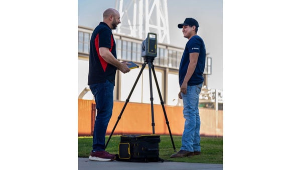
Trimble has provided advanced geospatial equipment to Fresno State’s Geomatics Engineering Program in collaboration with California Surveying & Drafting Supply, a Cansel company (CSDS). The equipment is designed to facilitate experiential learning in optical surveying, photogrammetry, GIS, GNSS and scanning workflows, helping to equip geomatics students with the skills needed for future careers. As part of this collaboration, Fresno State will open a Trimble Technology Lab on campus in 2026 as a place for students to get hands-on experience and training.
As the nation’s first four-year, nationally accredited geomatics program and California’s only Accreditation Board for Engineering and Technology-accredited four-year offering, Fresno State has long been a hub for training the geospatial professionals who power land surveying companies throughout the Western U.S., including entities like Caltrans and PG&E. CSDS, with its expertise in bridging academic needs with industry solutions, was instrumental in bringing Trimble on board to expand the program’s equipment inventory, foster innovation and ensure the program’s sustainability as a talent pipeline for California’s geospatial industry.
“This strategic alliance is key to revitalizing and aligning educational offerings with the cutting-edge tools that define the profession,” said Tom Cardenas, senior vice president at CSDS. “Beyond offering students a hands-on learning approach, this project establishes a scalable model for addressing the surveyor shortage through industry and education collaboration. It’s a clear commitment to reshaping the future of geospatial education in California.”
The Bureau of Labor Statistics reports a significant decline from 56,200 employed surveyors in the U.S. in 2010 to 47,770 in 2020. In California, where more than 2,000 surveyors depend on advanced technologies to support a booming construction and utility sector, the shortage poses a tangible threat to projects ranging from highway expansions to renewable energy installations.
“Fresno State is a critical pipeline for California’s geospatial workforce. The collaboration with CSDS and Trimble amplifies our collective mission to align educational offerings with the state-of-the-art tools that meet the demands of a rapidly evolving industry,” said Bryan Gibert, director of sales enablement at Trimble. “This collaboration is about creating an ecosystem that draws in talent and prepares them for immediate impact.”
The equipment includes Trimble GNSS base receivers, data collectors and network capabilities; Trimble S7 robotic total stations; Trimble DiNi digital levels; Trimble X9 3D laser scanners with T10x tablets; and licenses for Trimble Business Center, Trimble RealWorks and other highly technical software such as Trimble’s aerial photogrammetry module for TBC and Trimble eCognition. Trimble also outfitted Fresno State’s Geomatics Engineering program with several C5 mechanical total stations for a complete, turnkey solution. Both Trimble and CSDS provide configuration, calibration and on-site training for the technology.
“We emphasize hands-on training in our facility, complete with high-end computers, advanced distance learning tech and collaborative research projects with local agencies like CSDS,” said Scott Peterson, associate professor and program coordinator of the Geomatics Engineering Program at Fresno State. “While we had solid foundations from previous industry partnerships, we needed to expand with Trimble technologies to align our geomatics education with what the overwhelming majority of California professionals use every day. This turnkey solution, from GNSS to scanners and software, prepares our students for real-world challenges across geomatics and construction, leveraging our control network for practical training.”
My September GPS World newsletter highlighted the new California Spatial Reference Network, labeled CSRN Epoch 2025.00. These coordinate changes will impact geospatial users across California, and understanding the transition process is important for preparing for the modernized National Spatial Reference System (NSRS), expected to be adopted in 2026.
CSRC, founded in 1997 and formally dedicated in 2001, develops and maintains a modern network of GPS control stations to provide a reliable spatial reference system for California. Created as a partnership of surveyors, engineers, GIS professionals, the National Geodetic Survey (NGS), Caltrans, and the geodetic and geophysical communities, the CSRC’s mission is to produce a self-sustaining, up-to-date geodetic control network for the state.
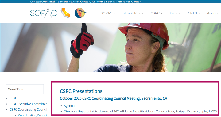
The CSRC holds Coordinating Council meetings to review CSRC activities and related state surveying and mapping efforts. The box titled “CSRC Coordinating Council 2025 Fall Meeting” lists the agenda for the most recent meeting. I attend these meetings virtually; they are consistently informative and I enjoy participating.
Image: CSRS website
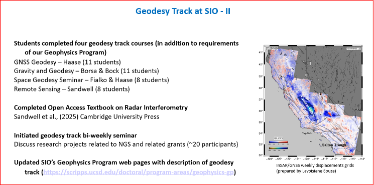
Dr. Yehuda Bock’s Director’s Report (SOPAC/CSRC Director, Dept. IGPP, Scripps Oceanography, UCSD) is available for download from the CSRC website: http://sopac-csrc.ucsd.edu/index.php/csrc-presentations/ (note: large file). At the Fall Coordinating Council Meeting Yehuda opened with a presentation on the new California Spatial Reference Network, CSRN Epoch 2025.00. I encourage readers to download the presentation or read my September GPS World newsletter, which highlighted CSRN Epoch 2025.00. This newsletter will focus on the Geodetic Program at Scripps Institution of Oceanography (SIO).
Image: CSRC website
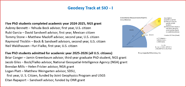
In my November 2023 GPS World newsletter, I noted NGS’s announcement of the NOAA FY23 Geospatial Modeling Competition awardees. In my March 2024 GPS World newsletter, I highlighted Scripps Institution of Oceanography’s (SIO) proposal. As noted there, Yehuda’s proposal included three activities:
Create a formal Geodesy Program at SIO to address the nationwide deficiency of geodesists. Expand current geophysics curriculum – funding for five graduate students.
Develop an IFDM to supplement the NSRS for users in regions with significant ground motions, using GNSS and InSAR/GNSS displacement fields (funded by NASA projects) and underlying geophysical models. CSRC will exercise the IFDM through its community of public, private and academic users of precise spatial referencing in our challenging region of secular and transient crustal movements.
Investigate a unified vertical reference frame, including a marine geoid optimized to be consistent with the full spectrum of observations from modern gravimetric geoids (e.g., GRAV-D, ICGEM), remotely sensed observations (e.g., SWOT, ICESat-2), in situ ocean observations and assimilating ocean models and the TRF.
As mentioned in the Director’s report, they have initiated bi-weekly geodesy track seminars to discuss research projects related to NGS and other grants. Four videos by students discussing their projects were shown during Yehuda’s presentation.
The following are the titles and presenters of the four research projects:
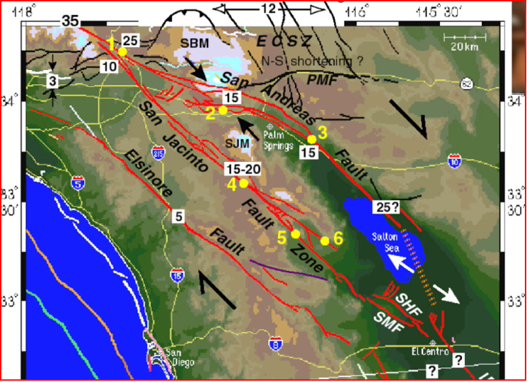
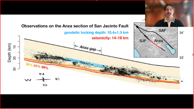
San Jacinto Fault Zone by Neil Waldhausen
Probing Antarctic basal ice state using airborne geodesy by Briar Conger
Repeat Pass Interferometry by Rubi Garcia Gonzalez
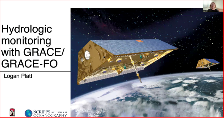
Hydrologic monitoring with GRACE/GRACE-FO by Logan Platt
San Jacinto Fault Zone by Neil Waldhausen
I have included a few bullets summarizing their project and a few captured images from the videos. I would encourage everyone to download the presentation to listen to the short videos by these students. The presentations are only 90 seconds but are very interesting. Readers can contact the speakers through the University to find out more about their research.
Summary of the “San Jacinto Fault Zone” video:
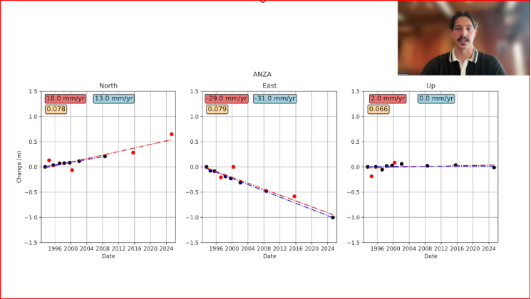
Neil uses GNSS to measure velocities and strain rates around the San Jacinto Fault.
He focused on the Anza gap, a 20-km segment of the fault.
He re-surveyed about 50 monuments that had been occupied over past decades.
His work has lowered uncertainties in many site velocity measurements.
His aim is to further reduce uncertainties in strain-rate and slip-rate estimates to better understand the Anza gap’s mechanics.
San Jacinto Fault Zone by Neil Waldhausen.San Jacinto Fault Zone by Neil Waldhausen.Image: CSRC website
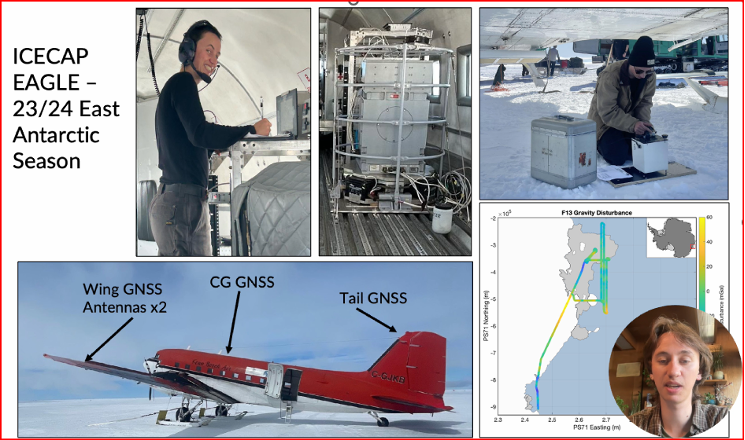
Summary of the “Probing Antarctic Basal Ice State Using Airborne Geodesy” video:
Briar’s project uses gravity and radar data to study basal hydrology — water flow beneath glaciers and ice sheets, including subglacial lakes, channels, and pressure-driven water movement.
He conducted fieldwork on the East Antarctic Ice Sheet during the 2023–24 season.
He collected airborne gravity and GNSS data from a converted DC-3 aircraft.
Data processing uses both PPP and differential positioning methods.
His aim is to improve long-term sea-level rise predictions.
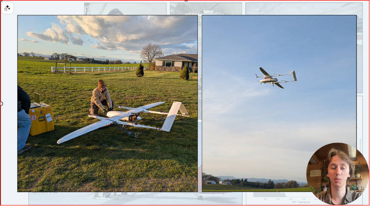
He is also developing a fixed-wing UAV capable of collecting lidar, gravity, and photogrammetry data.
Probing Antarctic Basal Ice State Using Airborne Geodesy by Briar Conger
Probing Antarctic Basal Ice State Using Airborne Geodesy by Briar Conger.Image: CSRC website
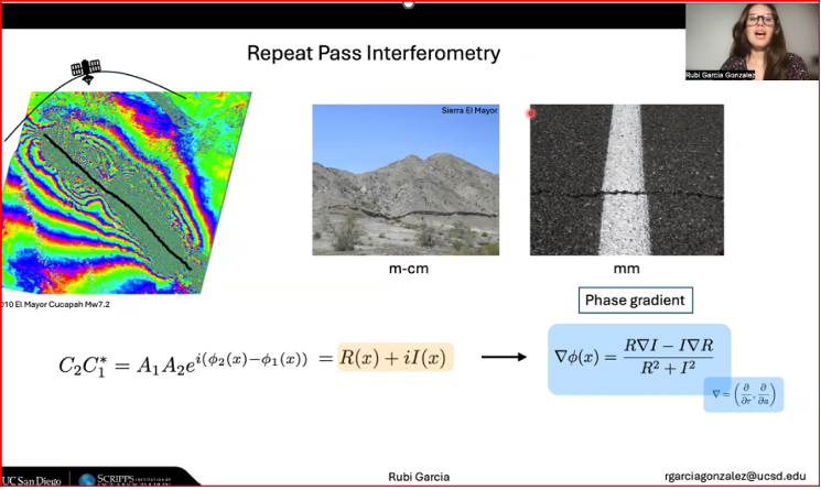
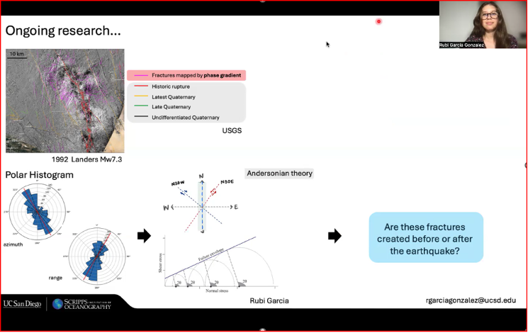
Summary of the “Repeat Pass Interferometry” video:
Rubi used repeat-pass interferometry (phase gradient) to map small-scale surface deformation.
The phase gradient is the change in interferometric phase between neighboring pixels; unlike the ambiguous single-pixel phase (wrapped within 2π), the gradient gives a continuous local rate of change useful for analysis.
She compared fractures identified by phase-gradient analyses with historic fracture databases.
Her ongoing work includes applying Andersonian faulting theory to assess whether fractures formed before or after earthquakes.
Andersonian faulting (Anderson’s theory of faulting) is a geological framework for interpreting crustal stress and fault geometry; it’s used to interpret InSAR-measured deformation. While not a method of analysis for InSAR data itself, it serves as a critical interpretive tool for understanding the ground deformation patterns measured by InSAR.
Repeat Pass Interferometry by Rubi Garcia Gonzalez
Repeat Pass Interferometry by Rubi Garcia Gonzalez.Image: CSRC website
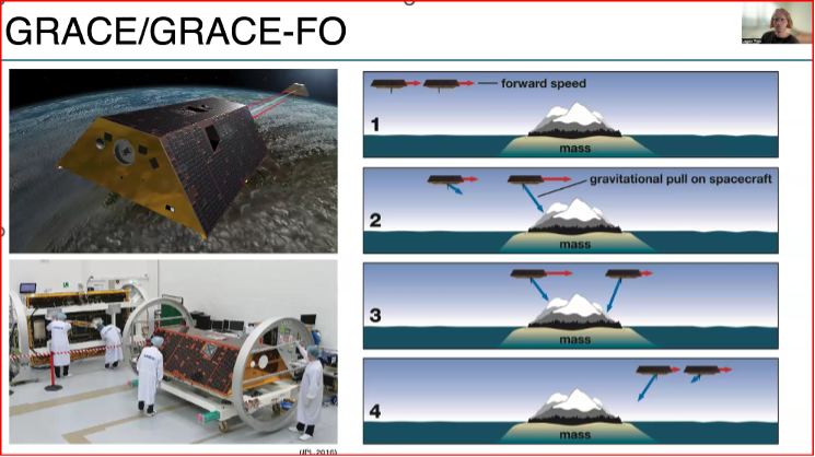
Summary of the “Hydrologic monitoring with GRACE/GRACE-FO” video:
Logan described using satellite measurements of tiny changes in Earth’s gravity to track mass movement and better understand groundwater and the water cycle.
He relied on GRACE and GRACE-FO data.
The Gravity Recovery and Climate Experiment (GRACE) and its successor mission, GRACE-Follow On (GRACE-FO), are Earth-observation missions that use twin satellites to precisely map changes in Earth’s gravity field over time. This unique method allows scientists to track the movement of mass, primarily water, around the planet
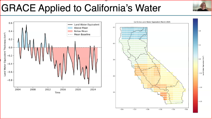
He used the GRACE data to look at changes in California’s Water storage from 2004 to 2024.
Results indicate a decline due to drought and heavy ground water usage, with more water being stored in northern California than southern California.
This research supports water management, climate-change impact assessment, and strategies for sustainable groundwater use.
Hydrologic Monitoring with GRACE/GRACE-FO by Logan Platt
Hydrologic Monitoring with GRACE/GRACE-FO by Logan Platt.Hydrologic Monitoring with GRACE/GRACE-FO by Logan Platt.Image: CSRC website
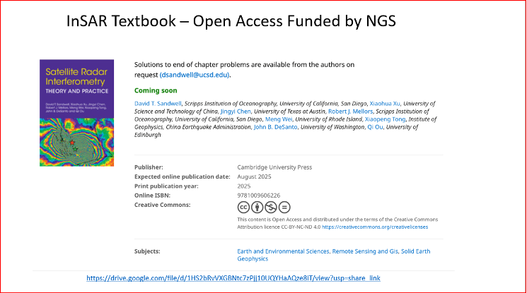
A new InSAR textbook, authored by several internationally recognized researchers, was also announced. Funded by the National Geodetic Survey and published Open Access, the book is available for free download. It’s a large file, but anyone working with InSAR data should obtain a copy.
New InSAR Textbook
Image: CSRC website
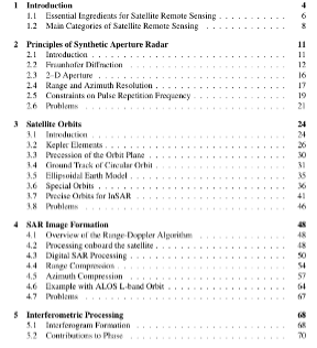
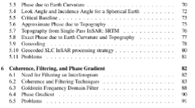
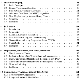
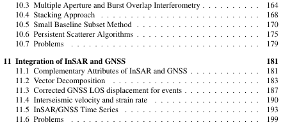
Table of Contents of New InSAR Textbook
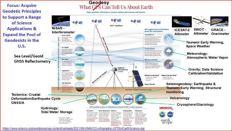
If you’ve read my newsletters, you know I’m passionate about advancing geodesy. I wanted to share one of Yehuda’s slides, “What Geodesy Can Tell Us About Earth,” because the four students are working on projects tied to real-world problems. The slide highlights geodesy’s importance and the many professions that rely on its findings.
What geodesy can tell us about Earth. (Image: CSRC website)
The California Spatial Reference Center (CSRC) modernized the California Spatial Reference Network (CSRN) on July 31, 2025. The new California Spatial Reference Network is denoted as CSRN Epoch 2025.00.
These coordinates changes affect California geospatial users, but the transition process to the new epoch is something that others should understand to prepare for the new, modernized National Spatial Reference System (NSRS), which is expected to be adopted in 2026. As I mentioned in my August 2025 newsletter, NSRS users should proactively assess their geospatial data dependencies and evaluate how adoption of the new datum will affect workflows, datasets and operational decision‑making.
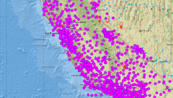
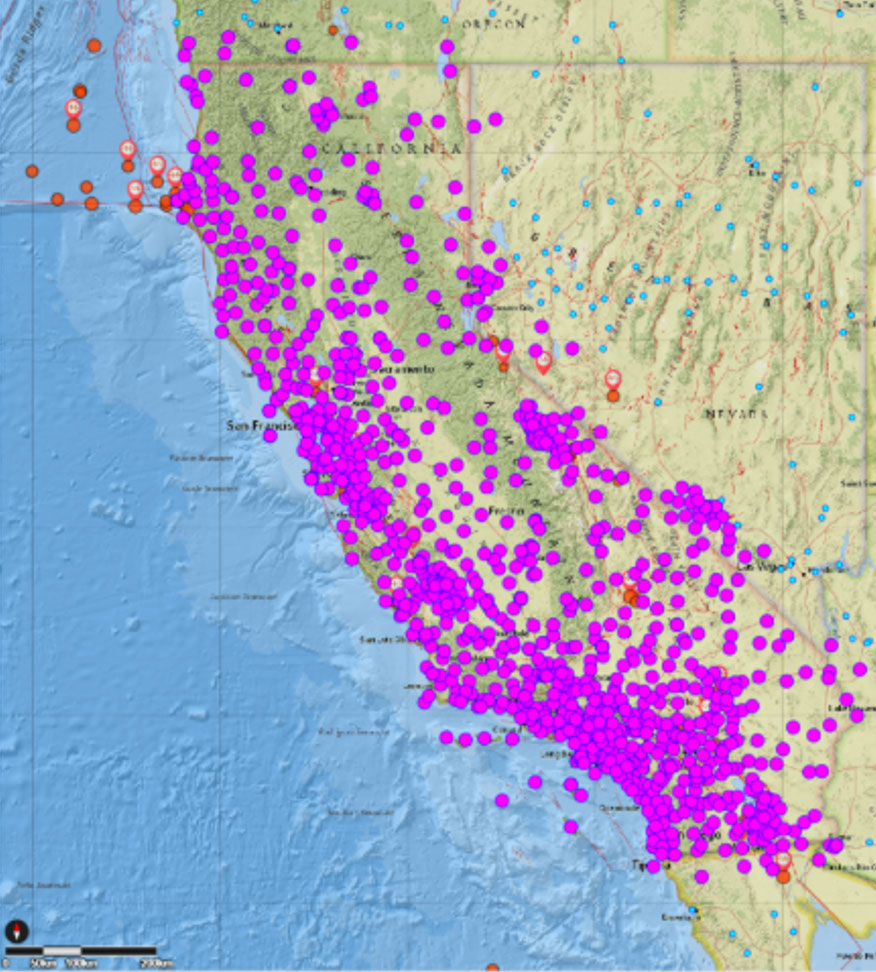
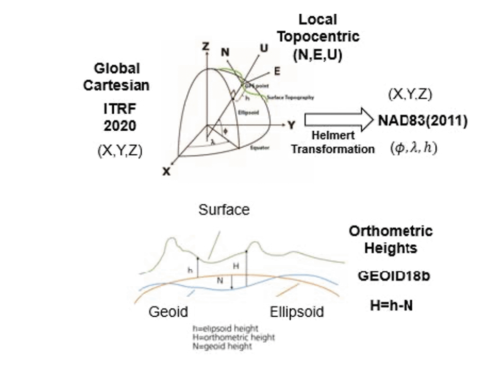
The California Spatial Reference System (CSRS) is the official geodetic datum in California, as published by the California Spatial Reference Center (CSRC) according to Public Resources Code (PRC) §§8850–8861. The image below depicts the CSRN. It is rigorously aligned to the current definition of the National Spatial Reference System (NSRS) through a set of coordinate transformations from ITRF2020 to NAD83(2011) as published by the NOAA/NOS National Geodetic Survey (NGS). The California Spatial Reference System (CSRS) is realized by the geodetic coordinates and uncertainties of the CSRN on the date of 2025.00 (January 1, 2025; GPS week 2347, day 3) of 1068 GNSS stations (881 active and 187 defunct stations) in California and at the borders of Arizona, Nevada, Oregon and Baja California. CSRN Epoch 2025.00 NAD83(2011) replaces the previous CSRS Epoch 2017.50 NAD83(2011).
The latest hybrid geoid model GEOID18 published by NGS was used to compute Global Navigation Satellite System (GNSS)-derived orthometric heights (DCOH) on the North American Vertical Datum of 1988 (NAVD 88) datum in accordance with the California PRC §§8890-8902 (California Orthometric Heights).
Plot of CSRN (Credit: SOPAC)
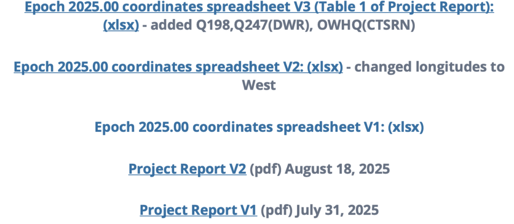
As previously mentioned, the new CSRC Epoch 2025.00 (NAD83 (2011) replaces the previously published CSRC Epoch 2017.5 NAD83 (2011). Readers can obtain the project report that provides technical information about the new realization at the following link: https://sopac-csrc.ucsd.edu/index.php/csrn-epoch-2025-00/ . The website provides web-links to the project report and a table of stations that includes information about the coordinates. See the image captioned “Excerpt from CSRC Epoch 2025.00 Web Page” for the links to the reports and tables. The CSRC Epoch 2025.00 realization is aligned with NAD83 2011, Epoch 2010.0. See the image captioned “Excerpt from Project Report V2” for the summary from the report. I have highlighted some sections of the summary that I thought others would find of interest.
This report, prepared under California Department of Transportation (Caltrans) Contract No. 52A0157, Task Order 1, documents the modernization of the California Spatial Reference Network (CSRN) by the California Spatial Reference Center (CSRC). This updated realization aligns the CSRN with the North American Datum of 1983 (NAD83 2011, epoch 2010.00).
The new reference frame, effective on January 1, 2025 (GPS Week 2347, Day 3), is called CSRN Epoch 2025.00 NAD83(2011), referred to for short as CSRN Epoch 2025.00. It replaces the previous adjustment at Epoch 2017.50 and remains a core component of the California Spatial Reference System (CSRS).
The CSRN is defined by the geodetic coordinates and uncertainties (Table 1) of 1,068 continuous GNSS stations—881 active and 187 inactive or decommissioned—located throughout California and bordering regions in Arizona, Nevada, Oregon, and Baja California, Mexico. As California’s official geodetic reference network under Public Resources Code (PRC) §§8850–8861, all Caltrans surveys using the California Coordinate System of 1983 (CCS83) must reference CSRN control stations or comply with CSRN specifications. The definition and use of CCS83 are governed by PRC §§8801–8819. This new realization is fundamentally tied to the International Terrestrial Reference Frame 2020 (ITRF2020) through the IGb20 coordinates adopted by International GNSS Service (IGS) Analysis Centers. All multi-year processing for this project was performed within this state-of-the-art global reference frame. Furthermore, the CSRN Epoch 2025.00 is rigorously aligned with the National Spatial Reference System (NSRS) maintained by the National Geodetic Survey (NGS). Epoch 2025.00 geodetic coordinates are transformed from ITRF2020 to NAD83(2011) using the NGS Horizontal Time-Dependent (HTDP) utility (Figure 1). The ITRF2020 coordinates (X,Y,Z) of the 1068 CSRN stations are transformed into geodetic coordinates (latitude, longitude and ellipsoidal height), using the GRS80 ellipsoidal parameters (semi-major axis, a = 6378137 m and inverse flattening, 1/f = 298.257 222 101).
CSRC submitted to the European Petroleum Survey Group (EPSG) definitions for datums, transformations, and coordinate reference systems for Epoch 2025.00 to facilitate unique terminology with associated metadata.
GPS data (phases and pseudoranges contained in RINEX data files) collected at the CSRN stations from June 10, 1992 to May 17, 2025, and about 300 global tracking stations of the IGS network were re-analyzed in the ITRF2020 reference frame. The complete set of RINEX data and metadata are accessible from the Scripps Orbit and Permanent Array Center data archive.
The latest hybrid geoid model GEOID18 published by NGS is used to interpolate geoid heights for each of the CSRN stations as the basis of Global Navigation Satellite System (GNSS) derived California Orthometric Heights (DCOH) on the NAVD 88 datum in accordance with the California PRC §§8890-8902 (California Orthometric Heights).
Figure 1. Reference frames for CSRN Epoch 2025.00 NAD83(2011).
As provided in the summary of the report, a diagram noted that the ITRF 2020 cartesian (XYZ) coordinates were transformed into NAD83 (2011) cartesian (XYZ) coordinates, and then into local topocentric coordinates (NEU) to obtain the CSRC Epoch 2025.00 NAD83 (2011) coordinates.
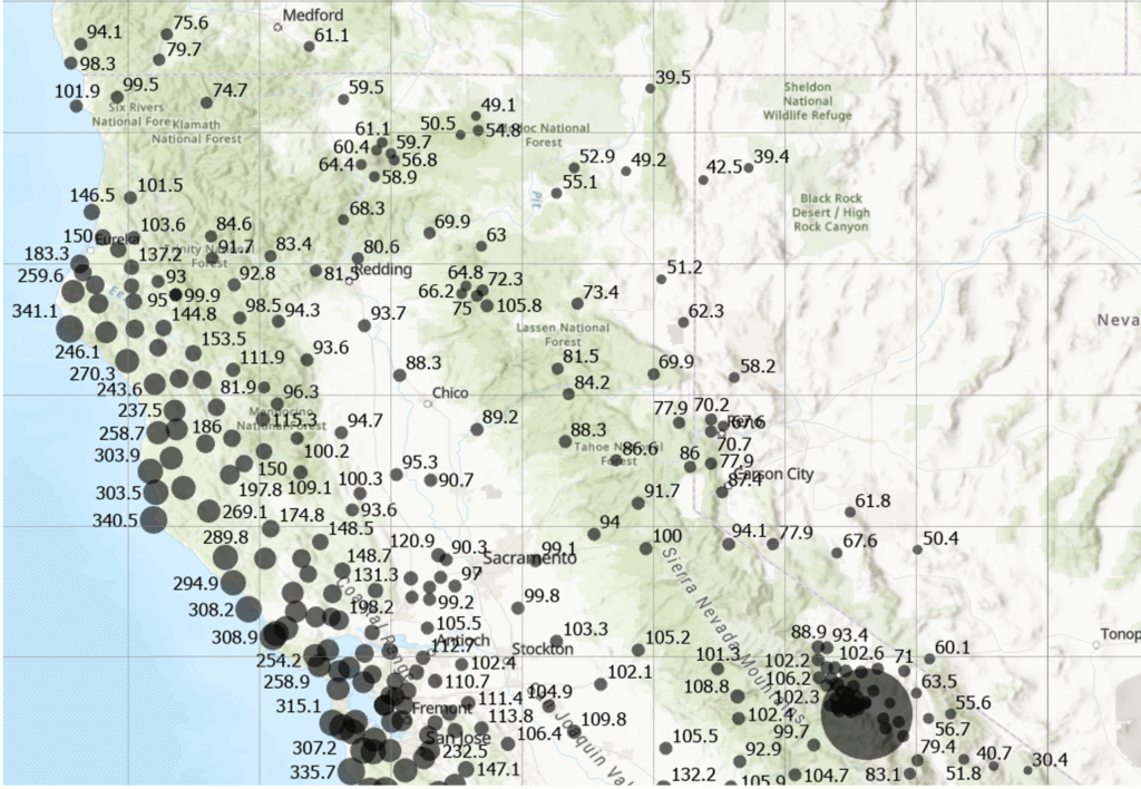
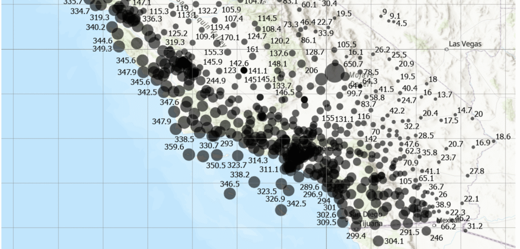
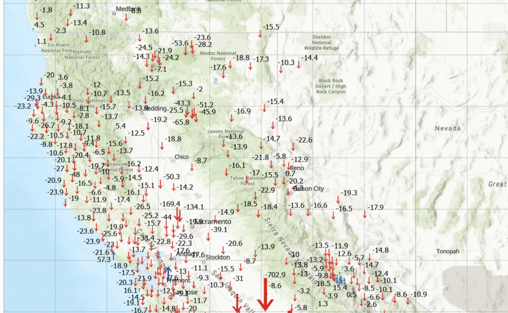
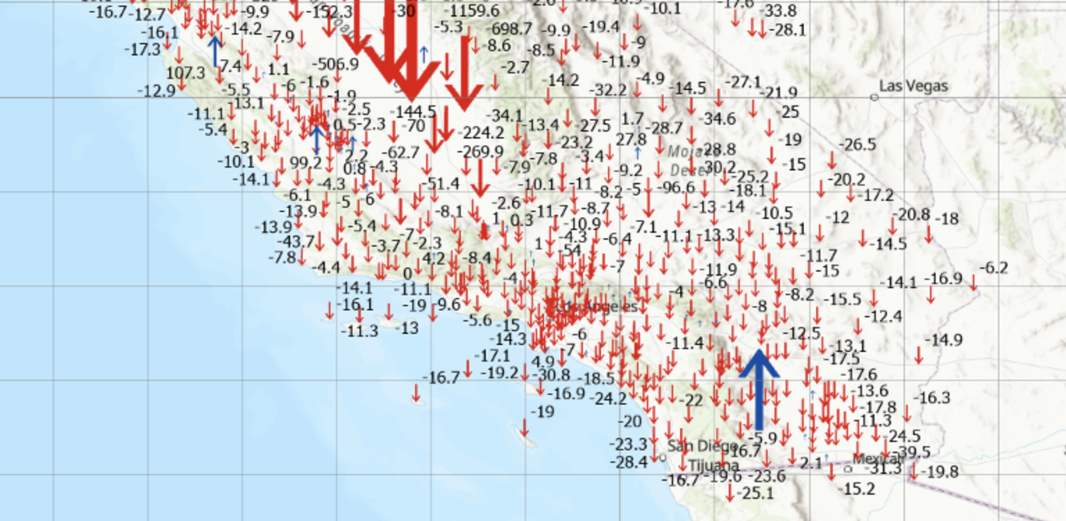
I downloaded the table of stations with their various coordinates and plotted the differences between the new CSRC Epoch 2025.00 NAD83 (2011) and the previous CSRC Epoch 2017.50 (NAD83 (2011) for stations that were designed as operational stations in 2025. The following plots depict the difference in coordinates between Epoch 2025.00 and Epoch 2017.50. One can see that there’s a reason that California needs to periodically update the coordinates of the California Spatial Reference Network. Some of the horizontal coordinates have changed over 300 mm or around one foot. The vertical coordinate changes are not as large, but some do shift more than 4 cm.
Note: The plots do not include newer stations with less than 6 months of solutions (no velocities estimated) and defunct stations (stations in Epoch 2017.50 but no data before January 1, 2025.
Differences in horizontal coordinates (N, E) between Epoch2025.00 and Epoch 2017.50 (northern section). Differences in horizontal coordinates (N, E) between Epoch2025.00 and Epoch 2017.50 (southern section). Differences in vertical coordinates (U) between Epoch2025.00 and Epoch 2017.50 (northern section). Differences in Vertical Coordinates (U) between Epoch2025.00 and Epoch 2017.50 (southern section)
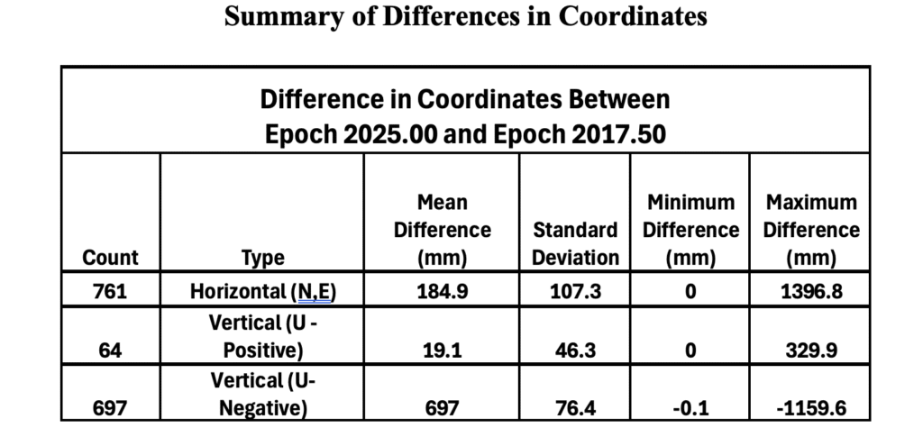
The image below provides some statistics about the differences in coordinates between Epoch 2025.00 and Epoch 2017.50.
Notes:
(1) Only includes operational stations in 2025
(2) Does not include newer stations with less than 6 months of solutions (no velocities estimated).
(3) Does not include defunct stations: in Epoch 2017.50 but no data before January 1, 2025.
This newsletter highlighted that the CSRC has adopted a new Public Resources Code–compliant geodetic datum (reference frame) for California: CSRN Epoch 2025.00 NAD83(2011), which replaces CSRN Epoch 2017.50 NAD83(2011). The updated datum incorporates secular (linear) tectonic motions across the North America–Pacific plate boundary, transient motions (such as coseismic and postseismic deformation and fault creep), vertical land motion (subsidence and uplift), and data from new stations established since Epoch 2017.50. Additionally, the new vertical datum provides a comprehensive set of California Orthometric Heights on the NAVD88 datum for all CSRN stations.
In essence, the CSRC has released three new datums. The first is tied to ITRF2020, the second to NAD83(2011), and the third to NAVD88. Transformation parameters are available between the first two datums. The NAD83(2011)-based datum satisfies California’s Public Resources Code requirements and is the recommended standard for geodetic control in the state. The NAVD88-based datum provides GNSS-derived California Orthometric Heights of 1988 (COH88).
These new datums will be added to the European Petroleum Survey Group (EPSG) database, the worldwide standard for coordinate reference systems (CRSs) and transformations. Each will receive a unique EPSG code, making it easy to reference and use. This will ensure that CSRN Epoch 2025.00 NAD83(2011), CSRN Epoch 2025.00 (ITRF2020), and COH88 Epoch 2025.00 (NAVD88) can be seamlessly integrated into industry software.
The CSRC report also noted that NGS has released a beta version of the modernized horizontal and vertical datums for the NSRS: NGS New Datums.
Once the modernized NSRS is fully published, and in response to the needs of California’s user community, CSRC will continue working to secure resources that support its partnership with NGS and ensure ongoing compatibility with national programs.
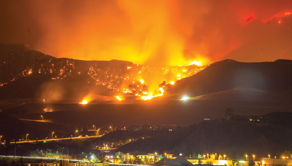
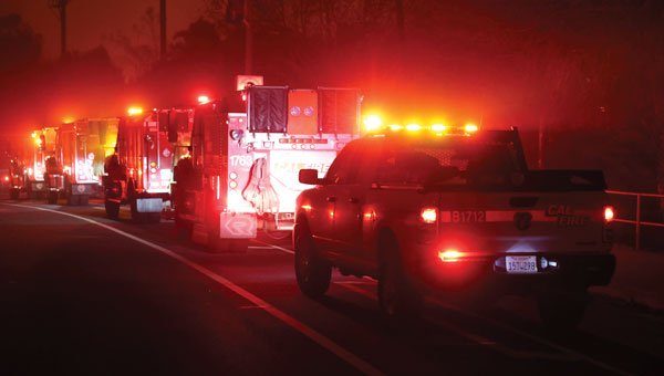
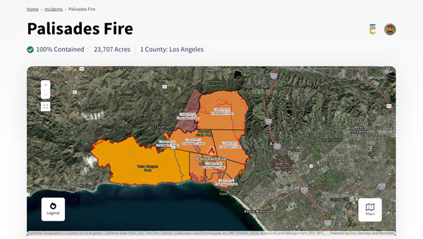
The Palisades and Eaton fires devastated parts of Los Angeles in January 2025 and are largely contained as of Jan. 20. Fueled by extreme Santa Ana winds and dry conditions, these fires have left a mark on the region’s landscape and community.
The Palisades Fire, which originated in the Pacific Palisades on Jan. 7, ultimately burned 23,448 acres, resulted in 12 confirmed fatalities and destroyed or damaged more than 6,800 structures, according to the California Department of Forestry and Fire Protection, known as CAL FIRE. The fire’s rapid expansion was particularly alarming, growing from a small brush fire to a massive conflagration within an hour.
Simultaneously, the Eaton Fire, which began near Altadena and Pasadena, consumed 14,117 acres. This fire proved even more deadly, with 17 confirmed fatalities and significant damage to more than 10,000 structures, according to CAL FIRE. Both the Palisades and Eaton fires have now been classified among the most destructive wildfires in California’s history.
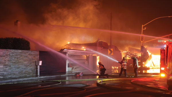
During times of emergency, geographic information systems (GIS) specialists come together to create real-time mapping tools to provide critical support to first responders and keep communities well-informed. These tools have become indispensable in modern disaster management, particularly in wildfire response.
Interactive 3D Maps
Firefighters and other specialists from federal, state, and local agencies work together to fight wildfires. GIS specialists develop interactive 3D maps to display fire perimeters, evacuation zones and other critical data. The geospatial data serves as the foundation for effective communication and decision-making, allowing firefighters and incident management teams to access information in near real-time to make informed decisions.
Fire GIS specialists Peter Rowland, Brett Adler and Dawn Hutchinson shared insights into their teams’ strategies for wildfire management. They emphasize the crucial role of geospatial tools in disaster response by delivering actionable intelligence. GPS World interviewed them during the California wildfires. Rowland and Adler were based at the Palisades fire, while Hutchinson, who is a member of a California Interagency Incident Management Team (CIIMT), was located near the Eaton fire.
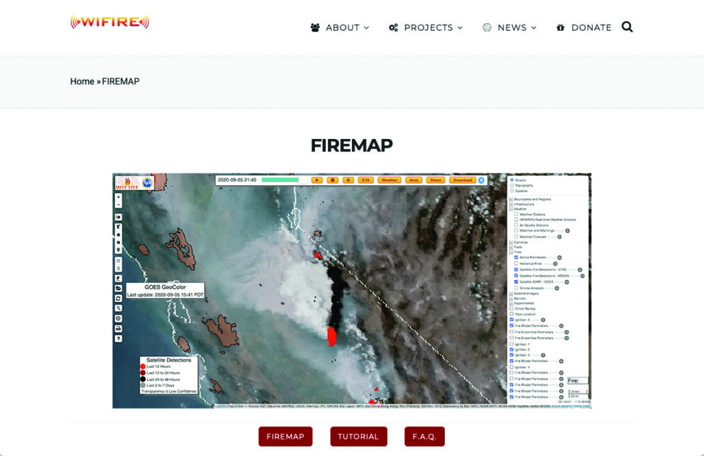
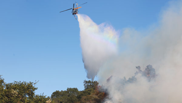
Interagency GIS teams use the Fire Integrated Real-Time Intelligence System (FIRIS) to watch for fire starts and then receive alerts from dispatch centers and satellite imagery. After locating the point of ignition, they create fire behavior models using a program called WIFIRE from UC San Diego. This tool allows them to predict the fire’s probable trajectory and size.
Photo: CAL FIRE
The team will alert the state if the data shows the fire is likely to spread. Hutchinson explains that, within minutes of the start of the Eaton fire, her team produced a fire behavior model that illustrated where the fire was most likely to go and how big it would likely get within the next three hours.
Photo: CAL FIRE
The frequency of IR flights depends on the fire’s size and intensity. Occurring anywhere from once to three times daily, including nighttime, these flights comprehensively map the landscape based on the fire’s specific traits. The decision on how often to fly the planes and collect the IR data depends on the fire’s behavior and potential threat level.
Field observers are also deployed daily to collect data down to the debris. They walk the fire’s edge and move along specific paths created for wildfire management and containment. Once a fire is contained, GIS specialists try to verify ground truth for the perimeter of the entire fire.
GIS specialists constantly update fire perimeters as they get data from the field and the planes. Once a fire is contained, they create final maps to hand over to the local agencies or the Forest Service.
Photo: CAL FIRE
Most of the data that GIS specialists use to map fires comes from field observers and infrared (IR) thermal imagery. The data is collected by third-party contractors, by CAL FIRE’s Intel shift team, or by the FIRIS program by flying manned aircraft.
IR data and information collected by field observers are then uploaded into the National Incident Feature Service (NIFS) for GIS specialists to use to map fires.
Field observers download the maps onto their devices, go out into the field, and ground truth — physically walking the perimeter of the fire and using GPS on their devices to map the fire boundaries accurately.
Photo: CAL FIRE
Paper maps are good to have “just to get everybody on the same page without having to worry about battery life or the glare while you’re working out in the field,” said Rowland.
Along with online maps, the Interagency GIS teams print PDF maps for fire personnel in the field. The field observers use Esri ArcGIS Field Maps to record their tracks. They pair their mobile devices with Avenza or other geolocating applications.
Using ArcGIS Pro, GIS specialists create online maps and dashboards, which are then distributed in print and/or digitally to the agencies that need them, such as sheriff and police departments and departments of public works. The Interagency GIS teams create different map products for different end users. For example, it works with law enforcement to create evacuation maps and zones. Local public information officers also can distribute these maps or post them on their websites.
Photo: CAL FIRE
Crews also have online access to the maps through wildfire FTP (ftp.wildfire.gov). Crews load data and maps there that contain public information. Many agencies plug into the National Interagency Fire Center (NIFC), where the CAL FIRE team edits and analyzes mobile data.
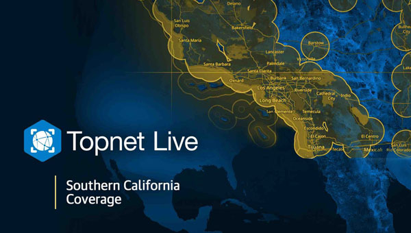
In response to the recent wildfires in Southern California, Topcon Positioning Systems is now offering free access to its GNSS correction services network for emergency recovery efforts. The company is offering a 90-day subscription to its Topnet Live service, which delivers precise positioning data crucial for assessing damaged infrastructure, surveying, utility mapping and operating construction equipment.
The technology is being made available at no cost within affected areas to support first responders, public works teams, and other professionals involved in damage assessment, infrastructure repairs, and rebuilding initiatives. The service is compatible with any brand of receiver capable of using RTCM format NTRIP corrections.
“We want to help the efforts that are ongoing and aid in the future reconstruction of the damaged communities from these wildfires,” said Jason Killpack, director of Topcon emerging business development. “The 90-day emergency subscription service is free to anybody that needs them to get their essential job done.”
Individuals or organizations seeking to activate this service can contact participating Topcon distributors in California. Contact information is available on the company’s website for those interested in utilizing the emergency assistance.
Landscape of Badwater Basin salt flats, with halite textures under a vibrant pink sky during sunset or sunrise at Death Valley National Park. (Photo: StephenBridger / iStock / Getty Images Plus / Getty Images)
The U.S. Geological Survey (USGS) has commissioned Woolpert to collect Quality Level 1 lidar data and conduct ground control surveys throughout Southern California in support of the 3D Elevation Program (3DEP) and The National Map.
Overseen by the USGS National Geospatial Program, 3DEP provides the nation’s first comprehensive, high-resolution topographic elevation data integrated into The National Map. The data will be accessible to local, state and national agencies to consider when making decisions that affect the immediate safety of life, property and the environment, as well as for long-term infrastructure planning.
Woolpert will collect roughly 60,000 km2 of aerial lidar data throughout Inyo County, California, including parts of the Mojave Desert and Death Valley National Park, using a Leica TerrainMapper. QL1 data are collected at eight points per square meter.
“Woolpert has had the honor of supporting USGS’ 3D Elevation Program since its launch nearly a decade ago,” said John Gerhard, Woolpert vice president and program director. “Critical decisions that depend on accurate and available elevation data are being made every day, and we are incredibly proud to continue our support for the U.S. Geological Survey and its commitment to completing the nation’s first-ever baseline of consistent high-resolution elevation data.”
Gerhard added that the data acquired for this project will also support the USGS 3D Hydrography Program (3DHP). The project is underway, and data is expected to be acquired by fall 2024.
K1000ULE in flight. (Photo: Kraus Hamdani Aerospace)
There was a lot of press noise in December 2023 about DOD’s Replicator program– which has been interpreted as a project to field thousands of U.S. UAVs to counter a perceived weakness in the face of China’s options for waging UAV war. Then there was a move by the Replicator program office to better explain its approach. It was reported as having at least four concurrent elements:
Encourage U.S. industry to conceive and implement ways to overcome the new aspects of conducting war and possibly use more UAVs more often.
Let China know that the United States is already on the move to not only keep up with but exceed Chinese capabilities.
Overhaul the extremely burdensome and slow existing DOD procurement machine to make large, rapid acquisitions.
Invigorate DOD military services to quickly adapt to find ways to use UAVs in multiple offensive and defensive roles.
Presumably, lessons learned in Ukraine — where both sides have been throwing both improvised and specially designed explosive drones at each other — and U.S. Red Sea encounters with Houthi rebels — have helped to frame some of Replicator’s objectives.
Anyone who has labored through a DOD request for proposal (RFP), RFP response, competitive re-bid and maybe even more competitive re-rebid that potentially led to months of questions and waiting leading to an ultimate reward or disappointment can imagine what hoops the procuring agency had to jump through. They can also imagine the time that elapsed from the definition of a requirement to a written firm procurement specification, and approval of a procurement package.
Never mind the allocation of procurement staff, establishing a budget and then processing of possibly multiple responses – this is a complex, arduous and time-consuming task for both industry and the procurement agencies. With help from the Defense Innovation Unit (DIU), it is anticipated that acquiring and fielding thousands of commercially available autonomous drones will now go quicker.
Imagine the inertia needed to change the way that military services use the materiel they’ve acquired and how difficult it might be to change what is bought and how it is used at the very front end of a war effort. When the opposition chucks many, small, inexpensive, airborne bombs at you and you do not have an immediate answer other than a limited number of multi-million-dollar interceptor missiles, it can be very painful. Matching drones with drones is essential.
Replicator was initially envisaged as a $1 billion program over two years to counter this and other problems for the warfighter.
On March 23, Congress finally passed the FY 24 $825 billion defense spending bill — almost six months late — which contained $200 million for Replicator, and DOD began to scramble to find an additional $300 million for the program’s first year. It should work out as there is money currently unspent from the FY23 budget that DOD has already requested Congress to re-allocate, and there is only a little more than six months left for this fiscal year anyway.
It is rumored that AeroVironment, with its Switchblade 600 semi-autonomous, one-way Kamikaze UAV, may benefit from an early Replicator procurement. With an anti-armor charge, Switchblade weighs about 50 lb and can fly for 24 miles and up to 40 minutes before engaging its target, allowing adequate time for manual intervention.
The U.S. Navy has selected a solar-powered UAV from a California start-up because it is the best demonstrated commercially available option for their Marine Corps scouting group.
The K1000ULE from KHAero in Emeryville, California is a long-range reconnaissance UAV.
With 24-hour flight endurance, extremely quiet and virtually radar-undetectable, the UAV provides the Marines with a suitable scouting tool – almost a launch-and-forget facility for day and night, most weather recon activities. It is also a relatively low workload for a team of only three to five personnel to transport and operate.
With vertical take-off and landing capabilities, the K1000ULE is ideal for covert autonomous operations from unprepared areas that a small squad might secure. The mission equipage includes full-motion video with target identification and classification and a secure communications systems.
With anti-jam, anti-spoofing multi-constellation GNSS, the vehicle can operate reliably in most signal-denied areas. It finds and automatically uses thermal columns to soar up to 20,000 ft and loiter undetected. It is capable of beyond visual line of sight (BVLOS) flight, can carry ADS-B for airborne collision avoidance and can be operated in swarms by a single operator when required – quite some UAV!
The Kratos XQ-58A Valkyrie Wingman UAV was developed to work with and on-behalf of high-end airborne assets, such as the F-22 and F-35, and is termed an ‘attributable’ adjunct to these ~$90 million fighter/ground-attack aircraft. Autonomous, driven by AI, and stealthy, the jet-powered UAV carries General Aviation electronics, along with other military communications. It is said to cost in the $5 to 10 million range — which makes it somewhat disposable if it is sent into a “tight or risky” location from which its fighter escort should hold back.
With a 3,000 miles range, 45,000 ft ceiling and carrying capacity of up to 1,800 lb of under-wing armaments, the aircraft can be controlled from an accompanying aircraft as a “Loyal Wingman,” or from the ground and be dispatched to carry out an autonomous, independent mission, requiring approval by a person to release weapons.
The XQ-58A was recently flown with two U.S. Marine Corps F-35 fighter jets at Eglin Air Force Base, Florida to demonstrate the capability for electronic attack and to fly alongside these fifth-generation high-end aircraft. The UAV autonomously detected, classified, and positioned multiple simulated targets during the exercise and provided target-tracking information to the F-35s.
The “Loyal Wingman” concept is still being developed and there are other companies, including Boeing Australia, flying competing prototype UAVs.
So, a more mil-spec tone to this month’s UAV updates, nevertheless a short recap of recent interesting unmanned, autonomous aircraft developments.
AUVSI XPONENTIAL 2024 will be held April 22 to 25 at the San Diego Convention Center in San Diego, California.
The event’s key themes include infrastructure and operations, technical research and development, data and analytics, cybersecurity and policy and regulations. The conference will feature keynotes, educational sessions, specialized workshops, and an XPO Hall with more than 30 exhibit categories with technologies across air, land and maritime sectors.
XPONENTIAL attracts more than 7,500 attendees each year, who attend more than 200 educational sessions as part of the full conference. The current keynote sessions include innovators with diverse perspectives and backgrounds who will speak on pressing topics and address key questions affecting the autonomous community.
Confirmed speakers include:
Doug Beck
Director, Defense Innovation Unit
Operationalizing DIU 3.0
Responsible for accelerating the Department of Defense (DoD) adoption of commercial technology through the military, Beck will discuss how defense agencies and industry can collaborate to strengthen national security. This session will be moderated by Courtney Albon, emerging technology reporter for Defense News and C4ISRNET.
Michael Brasseur
Chief Strategy Officer, Saab Inc.
To Create, To Make, To Shape
Drawing upon his role in implementing Saab’s future capabilities strategy, Brasseur’s presentation will address how individuals and organizations can foster an environment of continuous improvement and advancement.
Hal Brands, Ph.D.
Henry A. Kissinger, professor of global affairs, Johns Hopkins School of Advanced International Studies
Advancing Technologies and Their Role in World Affairs
Using his knowledge in foreign policy, international relations and security strategy, Brands will help leaders conceptualize strategies to safeguard national interests and organizations to navigate geopolitical challenges.
Henrik I. Christensen, Ph.D.
Qualcomm chair of robotics and professor, computer science, director of contextual robotics institute, UC San Diego
Looking Ahead: Robotics and Artificial Intelligence
Henrik will explore the future of these technologies and how stakeholders can form strategies that capitalize on emerging opportunities.
Harry Yeff (aka Reeps One)
AI Artist and AI for Good Activist
Undoing a Narrative of Fear
Yeff, a London-born, neurodivergent artist, will share how we can foster a constructive dialogue on responsibly integrating technologies such as artificial intelligence (AI) and autonomy. His performance art pieces, integrated with AI and voice technology, have been exhibited internationally and garnered more than 100 million online views worldwide.
Additionally, a Federal Aviation Administration (FAA) Panel titled “Getting to Go,” will cover safety standards, implementation challenges and obstacles to technology development and testing. Panelists include three representatives from the FAA: Timothy Arel, chief operating officer of the air traffic organization, Marc Nichols, chief counsel and Laurence Wildgoose, assistant administrator for policy, international affairs and environment.
Matt McCardle, head of global regulatory affairs and strategy at Amazon Prime Air will moderate the discussion.
GPS World staff will be attending the conference. To follow our live coverage, click here.
More speakers will be announced in the coming weeks. Click here to learn more and register.
The U.S. Department of Transportation (DOT) has approved $2.5 billion worth of bonds to help fund the Brightline West high-speed rail project connecting Las Vegas, Nevada, and Southern California.
The 218-mile line, estimated to cost $12 billion in total, will run along the I-15 median with electric trains capable of running at 186 mph.
The DOT previously approved private activity bonds of $1 billion for the project in 2020. The second tranche of private activity bonds brings the total to $3.5 billion. In December 2023, the DOT also awarded a $3 billion grant from President Biden’s infrastructure law to the Nevada DOT for the project.
In June 2023, DOT awarded a $25 million grant to San Bernardino County Transportation Authority (SBCTA) through the Rebuilding American Infrastructure with Sustainability and Equity (RAISE) Program to be used for the construction of the Brightline West stations in Hesperia and Victor Valley, California.
Brightline West is expected to break ground in early 2024.
savvy navvy has partnered with ProtectedSeas to bring ProtectedSeas Navigator data to boaters through the savvy navvy app.
After eight years of research and development, boaters and watersport users worldwide can now have access to comprehensive data and resources of ocean regulatory information, including marine protection areas, through the savvy navvy app.
ProtectedSeas Navigator provides boaters with 22,000 marine protected and managed areas in more than 220 countries. These areas include speed-limit zones to protect marine mammals, fisheries management areas and more.
ProtectedSeas compiles marine protection information into the Navigator database of marine protected areas (MPAs). It collects both large and small amounts of data and created the first public digital maps for more than 2,400 areas.
savvy navvy – often referred to as ‘Google Maps for boats’ – is an award-winning boat navigation app. It integrates multiple sustainable data sources from different conservation agencies and bodies.
Since launching its first global view of marine life protections, ProtectedSeas has been complimented by several industry-renowned leaders and bodies, including the U.S. National Oceanic and Atmospheric Administration (NOAA), Dr. Sylvia Earle, American marine biologist and oceanographer, and Gavin Newsom, governor of California.
Some ProtectedSeas data is already available in the savvy navvy app, with more to follow soon. Click here to learn more about the sustainable data or to download the app.
Autonomous vehicles are a truly fascinating innovation. Most modern vehicles on roadways around the world have some level of autonomy, ranging from Level 1 features such as cruise control to Level 5 fully autonomous features such as the ability to monitor roadway conditions and perform safety-critical tasks without intervention by a human driver.
Even though autonomous vehicles have been continually developed and tested for years, adoption has been minimal. According to the University of Michigan Center for Sustainable Systems, a majority of researchers, manufacturers and experts predict widespread adoption of Level 5 autonomous vehicles by 2030 or later.
Several barriers have delayed the adoption of autonomous vehicles, such as concerns about safety, data security and cyberattacks; lack of consumer demand; liability laws and lack of regulatory legislation; and doubts as to their economic viability.
While their adoption is slow, autonomous vehicles have been widely praised for the range of benefits they would provide. According to the U.S. National Highway Traffic Safety Administration, they include: much greater road safety due to features such as advanced driver assistance systems, lidar, cameras, inertial navigation systems and more; greater independence for people with disabilities, senior citizens and low-income individuals; reduced road congestion due to the lower number of crashes and an increase in ride-sharing; and environmental benefits as the automotive industry transitions to all-electric vehicles.
Several technology and automotive companies also have seen the potential benefits of autonomous vehicles for many applications and the potential impact they could have on communities worldwide. In response, these companies have supported autonomous vehicle innovation and adoption by offering new products and working closely with educators, nonprofit organizations and other groups who aim to leverage it to connect the world.
Education meets automated racing
Safran Electronics & Defense, which specializes in resilient positioning, navigation and timing (PNT) solutions, has advanced the adoption of autonomous vehicles with its simulation software while simultaneously supporting current students in their academic pursuits.
To jointly develop future PNT technology and solutions Safran’s Minerva Academic Partnership Program supports partnerships with the academic community by providing its technology for student-led research projects that use GNSS signals. Leisa Butler, the program’s chair, elaborated on its mission: “Collaborating with our customers in academia while advancing PNT education is the program’s core purpose. We provide members with access to our powerful Skydel GNSS simulation engine.”
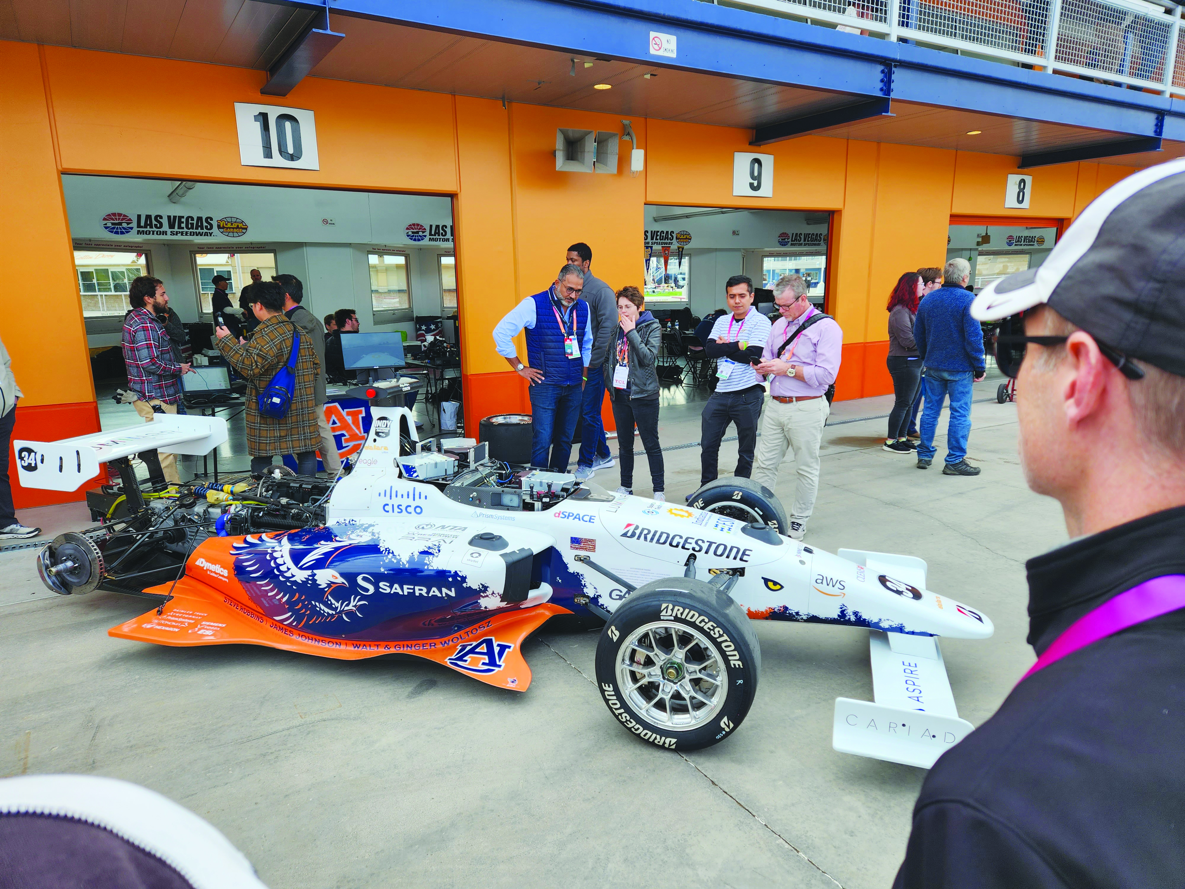
Safran and auburn university students are pictured with their autonomous F1 race car that competed in the Indy Autonomous Challenge on the Las Vegas Motor Speedway at CES 2023. Auburn students used Skydel, a Safran simulation engine, to improve the capabilities of the car and to learn how to make it safe and reliable on the track. (Image: Safran Electronics & Defense)
As a part of the program, Safran has a long-established partnership with Auburn University’s College of Engineering. Safran and Auburn University students participated in the Indy Autonomous Challenge, which took place on January 7, at the Las Vegas Motor Speedway during the 2023 Consumer Electronics Show. Nine autonomous Formula 1 race cars, representing colleges and universities from around the world, took part in a head-to-head driverless racing competition with some vehicles reaching speeds of more than 190 mph.
Safran has supported Auburn students before, during, and after this challenge by enabling them to leverage its GNSS simulators, such as Skydel and the GSG-8, which are used in the university’s autonomous vehicle lab. Butler said that giving students access to the simulation software prior to the high-speed races helped them troubleshoot and test the vehicles and improve the results.
“Resolving issues in the lab improves safety while saving time and money,” Butler stated. “The Indy car features multiple antennas. Since Skydel can support multiple instances simultaneously, the team can test heading and realistic scenarios in a simulated environment. This is before they race next to other vehicles at high speeds.
Safran also supports the general advancement of autonomous vehicle technology. Positioning and navigating autonomous vehicles involves the use of multiple technologies, including GNSS.
“Skydel is a valuable tool for the autonomous vehicle industry that wants realistic lab testing because it can support multiple, independent trajectories or antenna outputs simultaneously,” Butler said. She also pointed to the importance of developing mitigation techniques against jamming and spoofing.
“Using a simulator with the Skydel engine allows the user to test in all sorts of challenging environments before putting the wheels on the pavement. This lets the user make sure the vehicle is ready for real-world navigation and avoid costly mistakes. It also gives them a chance to practice and develop countermeasures against unintentional interference and malicious actors.”
Butler added that Safran is proud to support students who are helping to develop automated technology.
“Supporting Auburn’s Autonomous Vehicle team is an honor and a privilege. Student research represents the future of our industry,” Butler said. “We are proud to support them and see what they can accomplish with our simulation tools. We are confident that they will be able to gain valuable insights that will help them design, build and test their autonomous vehicles. It is our hope that their hard work will lead to the development of safe, efficient and affordable autonomous vehicles in the future.”
Accelerating mobility
Waymo, based in Mountain View, California, is an autonomous driving technology company. Formerly known as the Google self-driving car project, it was founded in 2009 and aimed to drive more than 10 uninterrupted 100-mile routes autonomously.
Its first fully autonomous ride on public roads took place in 2015, then Waymo became an independent self-driving technology company in 2016. It launched its first public trial of autonomous ride-hailing vehicles, called Waymo One, in Phoenix, Arizona in 2017, and has expanded its completely autonomous ride-hailing service trials to Scottsdale, Arizona, as well as San Francisco and Los Angeles.
The Waymo vehicle fleet also became fully electric this year.
360° Lidar, Radar, and cameras make up most of the technical elements of the fifth-generation Waymo fully autonomous vehicles. They also have redundant steering and braking, backup power systems, redundant inertial measurement systems for positioning, and more. (Image: Waymo)
Driving Change
According to its website, Waymo “represent[s] a diverse set of communities and interests, and we are coming together because we all share the belief that autonomous driving cars can save lives, improve independence, and create new mobility options.”
Some of Waymo’s community partners include Bike MS, the Arizona Council of the Blind, the Foundation for Senior Living, and Mothers Against Drunk Driving.
One community story to note is Waymo’s partnership with First Pace AZ — a supportive housing community for adults with autism, Down syndrome and other types of neurodiversity — to explore how Waymo could aid neurodiverse people.
Eli is a resident of First Place AZ and an adult with neurodiversity. He does not drive and relies heavily on ride-hailing services, carpooling, and the train to get to work and to volunteer. Not all public transportation is always available or accessible at certain hours. Additionally, human-driven rideshare and carpooling services can present bias from drivers and other passengers who do not understand the behavioral nuances of people who are neurodiverse.
To test the autonomous ride-hail Waymo One system, Eli and Natasha Grant, director of workplace and community inclusion at First Place AZ, hailed a ride to a local animal shelter.
After using the Waymo One service, Eli believed Waymo’s technology could help him stay connected to his community, wherever he may live in the future. Grant added that autonomous vehicles provide independence for individuals who may otherwise not be able to go to places to which they want and need to go.
Breaking social barriers
Community partners that fight food insecurity use Cruise’s autonomous vehicles to pick up left over food from businesses. (Image: Cruise)
Cruise is a self-driving car company based in San Francisco, California, and offers driverless rides in San Francisco; Austin, Texas; and Phoenix, Arizona. It was founded in 2013 by Kyle Vogt and acquired by General Motors in 2016.
Cruise first offered driverless ride-share services for its employees in 2017. In early 2020, the company began testing those driverless rides on public roads in San Francisco. Later that year, Cruise switched gears and repurposed a portion of its all-electric autonomous vehicle fleet to deliver meals to the community during the COVID-19 pandemic. It also began self-driving delivery trials in Arizona.
In 2021, Cruise announced plans for international driverless testing and expansion in Dubai and Japan. The next year, it opened its fully driverless service to public riders in San Francisco.
Delivering Hope
Cruise works with several community partners, such as the National Federation of the Blind, the SF-Marin Food Bank, and the San Francisco Giants.
“At Cruise, our commitment to social impact is a vital part of our business and an extension of our mission to improve life in our cities, especially for people underserved by transportation today,” the Cruise website stated.
In June, Cruise partnered with Replate — a nonprofit food rescue platform — to fight food insecurity and food waste in San Francisco and other communities. The partnership aims to use Cruise’s all-electric autonomous vehicle fleet, integrated with a national network of food recovery partnership from Replate, to pick up leftover food from local businesses and deliver it to organizations that help fight food insecurity.
The goal of the partnership is to create a sustainable cycle of food rescue that fights hunger and waste in local communities.
Xona Space Systems has partnered with the Air Force Research Laboratory (AFRL) and the U.S. Space Force under a $1.2 million Direct to Phase II SBIR (Small Business Innovation Research) contract to work toward a secure low Earth orbit (LEO) positioning, navigation and timing (PNT) constellation leveraging Xona’s PULSAR service.
The contract was awarded through an AFWERX SBIR Open Topic, after Xona demonstrated its LEO PNT technology using the “Huginn” demo satellite in late 2022.
Xona is developing PULSAR – a high-performance PNT service enabled by a commercial constellation of dedicated LEO satellites.
The PULSAR service aims to advance PNT security, resilience and accuracy capabilities by augmenting existing GNSS while also operating as an independent PNT constellation.
“Our partnership with the AFRL Space Vehicles directorate and USSF’s Space Warfighting Analysis Center will give Xona the expertise necessary to seamlessly integrate PULSAR into the U.S. national security space architecture,” said Brian Manning, CEO, Xona Space Systems. “Early assessment of unique DOD PNT requirements will set us up for a successful transition to operational service.”
Colonel Jeremy Raley, commander of the Phillips Research Site and director of the AFRL Space Vehicles Directorate, said the investment will contribute to force design analytics that consider contributing signals from multiple orbit regimes.
“Lessons from this effort will pave the way for future defense programs to successfully utilize commercial space assets for flexible and diverse satnav that is resilient to the adversarial threat,” Raley said.
Preceding the award, Xona became the first company to launch a privately funded PNT mission progressing from concept to on-orbit in less than 12 months. Since then, Xona has partnered with major companies such as Hexagon | NovAtel, Septentrio, Spirent, Safran, and StarNav. In April 2023, the company moved into its new headquarters in Burlingame, California, where the company plans to start the production of PULSAR satellites.