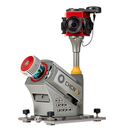
CHC Navigation has launched the Alpha3D Mobile Mapping solution, which provides a unique combination of sensor technologies and the company’s core GNSS expertise.
The Alpha3D is a high-performance, vehicle-independent mobile mapping solution that can capture mass data in continuously changing world environments, enabling geospatial professionals to get work done quickly and more accurately to increase their return on investment.
The Alpha3D can be mounted on a variety of platforms, including different type of vehicles, trains, railway trolleys and boats. It rapidly and efficiently collects high density, accurate point clouds and powerful image data. It also adds extra information from additional sensors, such as a high-resolution camera, thermal camera, echo sounder or extra profiler.
The Alpha3D combines high-performance hardware — including a long range, ultra-high speed, precise laser scanner, high-resolution HDR panoramic camera in combination with an advanced GNSS receiver and high-precision inertial measurement unit (IMU) — in one instrument in a light weight, compact yet rugged design, according to George Zhao, CEO of CHC Navigation.
“All theses features keep Alpha3D as one of most innovative system in market today,” Zhao said.
“With Alpha3D, users can collect more data faster and reduce time in the field more than 40% compared to traditional surveying instruments,” said Andrei Gobb, product manager of Mobile Mapping Solutions. “By combination of point clouds and high-resolution images, as well as information from additional sensors, there is no need to return to site for remeasurement.”
CHC Navigation has acquired the business assets and personnel of AMW Machine Control Inc. The business will now be conducted by AMW Machine Control Solutions Inc. as a subsidiary of CHC Navigation.
AMW Machine Control Solutions has more than 30 years of advanced machine guidance, machine control and GNSS experience. Its topographic and machine-control software solutions include grade, dirt, ditch, pipe, landfill and road. AMW Machine Control Solutions offers cost-effective solutions designed for equipment operators, the company said.
The offerings of AMW Machine Control Solutions will be based on turnkey, wireless CHC Navigation Android industrial tablets and CHC Navigation’s RTK GNSS receivers.
AMW Machine Control Solutions has appointed Phil Gabriel as president. Gabriel has more than 25 years of experience in the positioning industry. He previously served as president of Hemisphere GNSS Inc. and is currently serving as the general manager for CHC Navigation North America.
With these changes, CHC Navigation said it is poised to significantly grow its global market share in the agriculture civil engineering and construction industry, with products catering to small, medium and large enterprise farming and construction equipment users.
“Our customers really like CHC Navigation’s positioning products and their new Android tablets,” said Mark Williams, founder of AMW and now director of product management. “We have redeveloped our popular applications from the ground up to run Android while being more intuitive and wireless, wherever possible. With standardized hardware, AMW Machine Control Solutions will be able to better support our existing customers and to attract new ones.”
“AMW has been innovating in-machine control for many years. We are pleased to combine forces to offer the market incredible value and simple to use products,” Gabriel said.
At Intergeo, which took place Sept. 26-28 in Berlin, Germany, CHC Navigation’s George Zhao explains how the company first started exhibiting at the trade show, how the company has grown since and how the company plans to expand internationally.
CHC Navigation focused on its new GIS products at Intergeo 2016, which was held Oct. 11-13 in Hamburg, Germany. Balazs Hober discusses the LT600 GNSS handheld, DigiTerra Explorer 7 software and LT40 smartphone with L1 RTK capability that can achieve 30-centimeter accuracy.
Last year at InterGeo 2015, UAVs ruled, for at least the second year in a row, although some of its newest-thing gloss seemed to be wearing off. This year, sensor integration in both hardware and software is a dominant theme — and one with broader implications and applications.
GNSS positioning technology, aided in many cases by laser scanning, other imaging sensors, total stations, Lidar and camera systems, all collaborating as inputs to mobile mapping systems or machine-control systems, together form a durable platform for many present and future applications.
NavCom booth at InterGeo.
Among the GPS/GNSS companies exhibiting here: CHC Navigation, ComNav Technology, Eos Positioning Systems, Hemisphere GNSS, Navcom Technology, NovAtel, Septentrio, and Tallysman.
“I think it’s a must for every surveyor to participate and get updated with all the developments,” said Chryssy Potsiou, president of the International Federation of Surveyors (FIG), “to try to make the best combination of tools and software so that we can have the best output, in order to provide reliable services at affordable prices, in short time. The world needs solutions, cheap and fast.”
Smart Cities. Along with the roar of the four connected exhibition halls where many new products are being rolled out on this premier world stage, there is a lot of talk — a lot of talk — in the presentation auditoriums about vision, and smart cities, and connectedness in it many forms, electronic and otherwise.
The international trade fair for geodesy, geoinformation and land management, InterGeo can be overwhelming, with roughly 550 exhibits from 33 countries, and 16,000 visitors from 92 countries. It spans everything from surveying, geoinformation, remote sensing and photogrammetry to complementary solutions and technologies, processing, using and analyzing geodata over the Internet and exploring new applications and solutions — it’s all here. Themes include mobility, energy supply, climate protection, and liveable cities and rural areas. Citizen involvement, data protection, data security and e-government all play a key role in future developments. This year, the conference published a pre-show report on geodata and what it calls Business World 4.0.
Host city Hamburg, an economically strong, vibrant city and one of the top three shipping ports in Europe, embraced digital strategy at an early stage. Sustainable city planning, climate protection, an intelligent mobility concept and IT-controlled port management are all aspects of the city that could not work without geodata.
Making Connections. “Our [geospatial] industry is now more and more related, more and more embedded with many other disciplines,” said Nigel Clifford, CEO of Ordnance Survey UK, who gave one of the conference keynotes. “One of the key questions we are facing is: What skills will the workforce of the future need to have, in order to flourish in this interconnected world?
“Some of the more obvious ones are digital capability, looking at data sciences. Also we spoke about some of the softer skills: the ability to look across disciplines, the ability to work with different functions, and really importantly, the ability for our industry to explain its value and be part of the decision-making which is going on around us all the time.
“We’re beginning to see the first fruits of the Internet of Things. There may be some inflated expectations at this point. It’s our job to test that. I’m confident there are some brilliant use cases developing over the next five years in the fields of health, transport, and community engagement. Making a city more efficient, more livable, more secure, and more business-friendly, to draw tax dollars into the equation. What we’re able to do today is so much more data-rich, so much more connected, than we’ve ever been able to do before. ”
He cited pilot public-private partnership projects in Manchester and another unnamed UK city going forward in this regard, with involvement from Cisco, Siemens, and British Telecomm along with Ordnance Survey. “It’s a mixed economy coming together, because there isn’t one answer.”
Looking into the future, he said “Developing nations in particular require a fundamental geospatial fabric in order to boost themselves. I hope there will be a broadening of the focus from what we can do absolutely at the cutting edge of technology with reasonably affluent societies, to thinking about how we can take that into the less affluent societies, and raise all boats through the efforts of this great industry.”
Gorillas Enter Room. Intel has taken a stake in the commercial drone space with its new Falcon UAV. “Predominantly, we are looking at inspections, construction, agriculture, as well as 3D modeling.” The company was joined by Oracle and Autodesk as first-time exhibitors at the show, and they did not enter timidly; big stands.
UAV über Deutschland. In moves shadowing those in the United States, the German Minister for Transport spoke about introducing regulations to govern civil and commercial use of UAVs. The newly published draft foresees the introduction of mandatory registration for unmanned aerial systems. Pilots will need a valid license to fly drones above 100 meters.
TerraGo is partnering with Positioning Solutions International (PSI), a provider of high-accuracy positioning solutions for infrastructure, land management, agriculture and related industries.
PSI is an authorized reseller of TerraGo Edge software and offers a full range of turnkey systems and services that combine mobile data-collection software from TerraGo with high-accuracy GNSS receivers from CHC Navigation.
“What’s great about TerraGo Edge is that it’s designed to be customized out of the box, so we can give our customers and dealers a mobile solution tailored to their specific industry and unique workflow requirements,” said Charlie Towne, president, Positioning Solutions International. “And because it integrates seamlessly with the line of CHC receivers, we can provide any level of accuracy the job requires, even real-time centimeter RTK, directly on a smartphone or tablet.”
“The PSI team has decades of experience deploying high-accuracy positioning technology to meet the most demanding customer requirements, and they understand how to help organizations use BYOD solutions to seamlessly replace legacy, proprietary technology,” said John Timar, vice president, Worldwide Sales, TerraGo. “They bring the industry experience and subject matter expertise to our projects that guarantee successful outcomes for our mutual customers using TerraGo Edge, so they can improve accuracy while realizing tremendous cost savings and improving efficiency with a modern, mobile solution.”
PSI provides solutions to customers and a network of value-added dealers, and is the exclusive southeastern regional territory distributor for the CHC Navigation brand of GPS/GNSS products and network solutions.
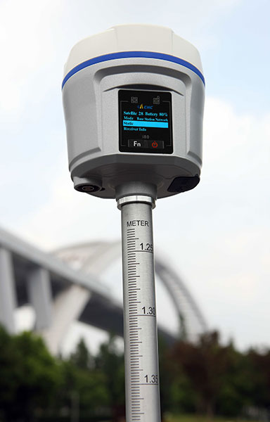
CHC Navigation has announced in a news release the availability of its new GNSS receiver, the i80.
The i80 receiver for surveyors and contractors is able to compute a true triple frequency RTK tilted pole sub-centimeter solution using all four worldwide and multiple regional constellations.
“Over two years of R&D and testing went into the creation of our Linux OS i80 platform,” said George Zhao, CEO of CHC.
The i80’s LCD GUI allows for common workflow operations, such as Static Logging, AutoBase, AutoRover, and UHF channel selection to be easily performed without the need of a data collector or computer. The CHC i80 is the smallest receiver on the market with dual hot-swappable batteries, CHC says. The receiver contains a full array of sensors and modules: multiple MEMS, Internal Tx/Rx UHF, multi-band cellular modem, Wi-Fi, Bluetooth, Serial, USB and more.
“This innovative design will allow us to add new functionality [with over the air updates] for years by combining the sensors and modules in new ways — this is illustrated by our LCD supported work modes, and our MEMS enabled unleveled pole surveying added in the last couple months during product rollout,” Zhao said. “We are bringing GNSS in to a new era of productivity and ergonomics in a low-cost open platform allowing for unrestricted third-party integration via our i80 API.”
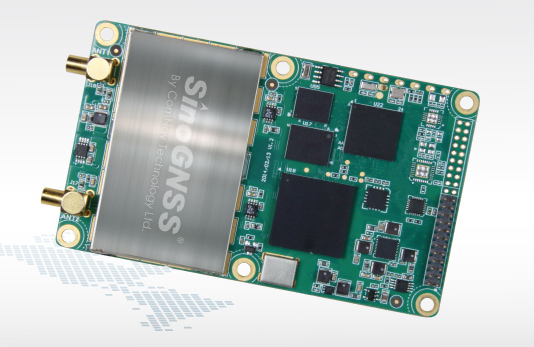
Positioning and heading for mission-critical applications
The K528G dual-frequency, multi-constellation GNSS board provides the highest accuracy in differential positioning. It benefits from numerous constellation signals because of its advanced tracking performance of both GPS and GLONASS. The K528G can provide positioning and heading information generated by two antennas. It is designed for guiding and positioning construction engines, dredges, barges, shipping container cranes, mining equipment and intelligent transportation systems.
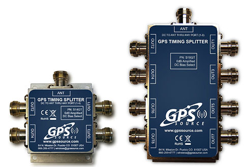
Designed for small-cell and distributed antenna systems
GPS Source has released of a line of GPS/GNSS splitters created for the small-cell wireless and distributed antenna system markets. Specifically designed for the L-band frequency, they can eliminate the cost of multiple antennas and long cable runs in wireless installations. With four or eight outputs, the new line of splitters make it possible to use a single GPS referencing antenna and cable arrangement for multiple synchronized systems. The splitters include features such as DC bias select and amplification. GPS Source RF signal splitters typically operate in conjunction with an active GPS antenna; consequently, a GPS RF signal splitter must have provisions for managing the DC voltage to the active GPS antenna. The S14GT and S18GT splitters will power an external GPS antenna from any of the RF outputs. A “hunt-and-pick” circuit is used to select only one DC input for power should more than one source be connected. Designed for redundancy, if the selected DC bias input should fail, the DC bias will automatically switch to another DC input to ensure an uninterrupted power supply to the active antenna.
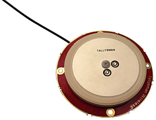
For precision industrial, agricultural and military OEM applications
A new series of L1 band wideband antennas for OEM applications is offered in three formats:
▪ TW2106/TW2108 — GPS L1
▪ TW2406/TW2408 — GPS + GLONASS
▪ TW2706/TW2708 — Galileo, BeiDou, GPS + GLONASS
Each antenna type features Tallysman’s Accutenna technology, which provides high rejection of multipath signals, with low axial ratios and tight phase center variations (PCV). Each is available with a brickwall pre-filter option to protect against saturation by high level subharmonic and L-band signals. The antenna printed circuit boards (PCBs) are 56 millimeters in diameter with four plated holes for secure mounting. They are available with a variety of connectors and custom cable lengths, and can be custom-tuned. All of them are REACH and ROHS compliant.
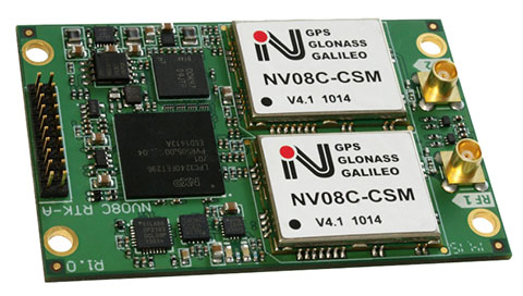
The NV08C-RTK-A is fully integrated multi-constellation L1 heading receiver with embedded real-tiime kinematic (RTK) functionality and compatibility with GPS, GLONASS, Galileo and BeiDou. The NV08C-RTK-A is designed for use in high-accuracy applications that demand low-cost, low-power consumption, a small form factor and high performance, such as construction, mining and industrial; environmental and structural monitoring; machine control; parallel driving systems; precision agriculture; UAVs; and robotics and intelligent machines.
The SLD-100 GNSS Rover accessory facilitates hydrographic measurement in bodies of water up to 100 meters in depth. it is designed for anyone who finds themselves needing to survey into bodies of water, streams and rivers. With survey-grade accuracy, the SLD-100 can be added to any brand GNSS RTK rover to allow for position and depth measurements to be made simultaneously. With a built-in 10-hour lithium battery and transmitter unit with Bluetooth connectivity, the SLD-100 provides standard-depth data streams in several industry-standard NMEA formats at 1 Hz, 4800 bps, providing compatibility with any hydrographic surveying software package. Position and depth information is externally logged on a computer or controller. Included transom mounting hardware enables easy installation.
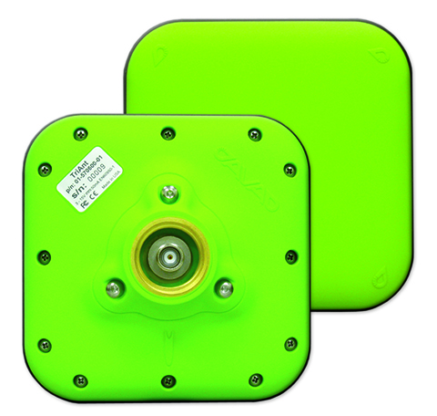
TriAnt is small, thin and rugged high-performance GNSS antenna. It measures 128 x 128 millimeters (mm) square and 39 mm thick. It can be mounted with three screws to flat surfaces. It is designed for applications such as machine control and surround anennas of the TRIUMPH-4X. The antenna cable is routed through the center of the antenna (TNC connector) for protection in harsh environments. The TriAnt can also be mounted on poles (1–14 inches thread) using its mount-pole attachment, which increases the thickness to 54.5 mm.
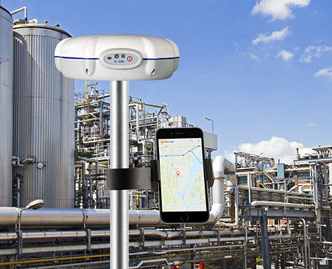
The X20i L1 GPS receiver by CHC Navigation is powered by a high-precision L1 GPS engine. Its integrated Bluetooth chip enables it to wirelessly collect submeter positions in real- time or centimeter post-processed on an iPhone or iPad. All location-aware apps on the iPhone and iPad are compatible with the X20i. Immediately after pairing and answering the security question allowing the X20i to take control of location services on the iOS device, 1 million iOS applications are capable of utilizing the high-accuracy data of the X20i, and become accurate to either 1 foot or 1 centimeter. Apps that can make use of the high accuracy include TerraGo Edge, ESRI’s ArcView Connector and those by CarteGraph Systems.
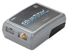
BlueStarGPS offers both GPS and GNSS options in a rugged, lightweight package. The BlueStarGPS device was designed to meet sub-meter mapping and data-collection needs in the pipeline and utility industries. It provides sub-meter precision without post-processing, and maintains accurate positioning when the SBAS signal is obstructed. This means it can function under trees, around buildings and in rugged terrain where other receivers can fail. The BlueStarGPS is designed specifically for use with Android mobile devices, such as smartphones, tablets or notebook computers, as well as cable and pipe “locating” tools with a connectivity range of up to 1 kilometer.
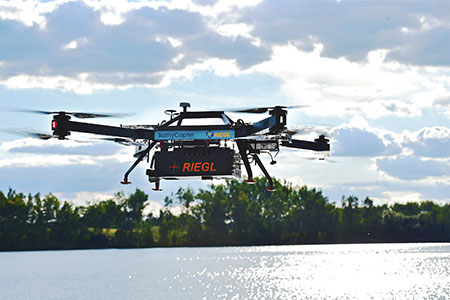
UAV measures through water surfaces of rivers, lakes
The RIEGL BathyCopter is a small-UAV-based surveying system capable of measuring through the water surface. It’s suitable for generating profiles of rivers or water reservoirs. The platform design integrates a topo-bathymetric green laser depth meter, an APX 15 inertial measurement unit (IMU)/GNSS with antenna, a control unit and a digital camera. Applications include generation of river profiles, survey of reservoirs and canals, landscaping, support of construction projects, and surveys for planning and carrying out hydraulic engineering work.
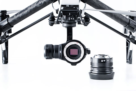
The Zenmuse X5 is a micro four-thirds (M4/3) camera designed specifically for aerial use. With a large sensor, aerial image makers will be able to capture up to 13 stops of dynamic range, enabling capture of high-resolution 16-megapixel photos or 4 k, 24 fps and 30 fps videos in complex lighting environments. It supports four interchangeable lenses. The Zenmuse X5 is designed for creation of high-quality aerial maps and 3D models, industrial and utility inspection, and professional video capture.
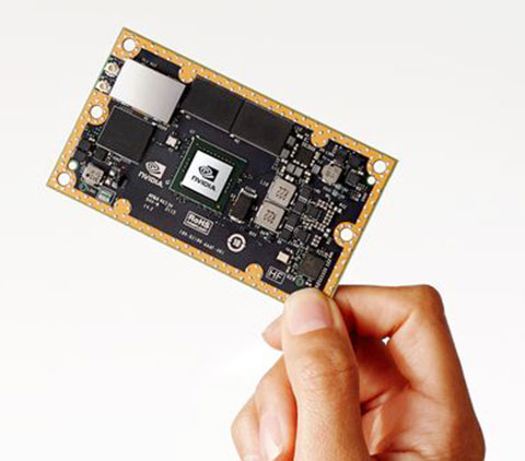
The NVIDIA Jetson TX1 module is designed to power smart devices — including drones that don’t just fly by remote control, but navigate their way through a forest for search and rescue. It is an embedded computer designed to learn to recognize objects or interpret information, incorporating capabilities such as machine learning, computer vision and navigation into a single system. This technology expands the ability of machines to operate on their own and adapt to their surroundings by recognizing images, processing conversational speech, or analyzing a room full of furniture and finding a path to navigate across it.
Lance Andre, regional sales manager for North America at CHC Navigation, introduces CHC’s new positioning products at INTERGEO 2015, which was held Sept. 15-17 in Stuttgart, Germany.
The X20i L1 GPS receiver (repurposed from the X20) now enables all apps on Apple’s App Store to have 1 foot to 1 centimeter accuracy depending on which version of the X20i is being used. By purchasing a special chip from Apple, iPhones and iPads can bond to the receiver using Bluetooth technology.
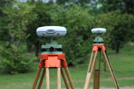
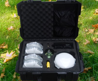
The UAV Ground Control (UAV GC) and post-processing kit for high-precision UAV systems by CHC Navigation.
CHC Navigation has launched a new UAV Ground Control (UAV GC) and post-processing kit for high-precision UAV systems. This kit is designed to provide an easy-to-operate complete system, and be cost-effective for producing centimeter-level control for UAV projects.
The standard kit includes five GNSS receivers with expansion of additional receivers in pairs. The core of the system is the X900+OPUS, a dual-frequency triple-constellation receiver capable of cm positioning of the project at 200 km in absolute geodetic space. The secondary X20+ receivers serve as ground-control points for orthorectification, project verification, and other high-accuracy positional tasks.
“Low cost and easy to use, the CHC UAV GC system is a necessity for any UAV manufacturer or operator who is interested is promoting/proving the high accuracy of their deliverables,” said George Zhao, CEO of CHC Navigation. “The UAV Package offers unrivaled performance at an unheard of low price, and fills the last remaining gap for a complete whole product solution in the UAV market.”
The UAV GC kit is now available through the existing CHC distribution channel worldwide.