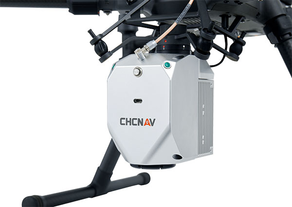
CHC Navigation (CHCNAV) has released the AlphaAir 450 (AA450) lidar system, a lightweight, compact all-in-one sensor for unmanned aerial vehicles (UAVs).
Featuring an inertial measurement unit (IMU), GNSS, 3D scanner and camera, the AlphaAir 450 solution is suitable for power-line inspections, topographic mapping, emergency response, agricultural and forestry surveys. The unit is easy to use, and can be rapidly deployed in the field to collect geospatial data.
“Despite the fact that the lidar scanning is an efficient technology to capture 3D data, it still often remains costly and complex to operate,” said Andrei Gorb, product manager of CHC Navigation’s Mobile Mapping Division. “Taking that into account, we introduce the AlphaAir 450 (AA450), a breakthrough lidar scanner that delivers user-friendly and high-accuracy capabilities at a reasonable price.”
Key aspects of the AlphaAir 450
Lightweight. The lidar’s weight is a constraint for any drone. The AlphaAir 450 weighs 1 kg, which is suitable to most drones’ payload requirements. The lighter the unit, the longer the operating time of the drone, and the greater the productivity. The AlphaAir 450 can be easily mounted on UAVs, making data capture efficient.
Advanced Accuracy. By combining industrial-grade GNSS with a high-precision IMU, the AlphaAir 450 can easily achieve an absolute accuracy of 5 cm (vertical) and 10 cm (horizontal) for small survey areas — typically adequate for the most use cases. To further improve precision and accuracy, users can apply adjustment algorithms in the CHCNAV CoPre software.
Industrial Reliability. Featuring IP64 high-level protection, the AlphaAir 450 extends its operating temperature capabilities, down to –20° C and up to +50° C in any field environment. This can increase users’ return on investment by providing more field survey days in a year.
In September 2019, the Xinjiang Institute of Ecology and Geography conducted a nine-day project on the Heishan Mining Zone in Toksun County, Xinjiang Province, China.
The CHCNAVBB4 UAV was combined with the AlphaUni 900 lidar solution to capture data and produce a topographic map of the mining area at a scale of 1:500. The point-cloud data was collected for subsequent 3D modeling to facilitate asset management and inventory work.
In another project, CHCNAV provided training and equipment for a China Railway No. 10 Engineering Bureau project. For this project, CHCNAV’s BB4 UAV was combined with the AlphaUni 1300 lidar system and deployed to study the topography of the tunnel mouth in Liangshan, Sichuan province.
The BB4 is a high-end unmanned aerial system resulting from an alliance between the two companies in their respective segments. Its scientific design and highly integrated production technology come from CHCNAV — a global manufacturer specialized in efficient geospatial measurement technologies — and its fully automated flight control system from DJI, pioneer in the manufacture of commercial UAVs.
The AlphaUni 900 and AlphaUni 1300 are high-end multi-platform lidar systems, designed and improved by CHCNAV through many years of exploration and data-capture experience. Both are fully integrated systems with high-precision, long-range laser scanners that provide unique waveform lidar technology from Riegl and a high-accuracy inertial navigation system.
The AlphaUni systems can take on demanding surveying missions in the air and on the ground that require the highest quality of data.
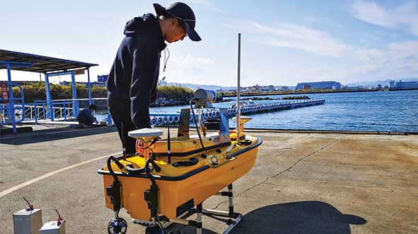
Sometimes hands-on data collection just isn’t good enough. In the busy Shizuoka harbor, Weichao Liu of CHC Navigation used the company’s Apache6 marine drone to take a bathymetric survey of a channel in preparation for dredging at a Shizuoka seaport. The Apache6 also collected 3D lidar data above the water’s surface.
In May, CHC Navigation launched the 2020 Edition of the Apache6 USV (unmanned surface vessel), which combines a dual GNSS positioning and heading receiver, stable and reliable hull attitude sensors, and an inertial measurement unit (IMU). The CHCNAV GNSS/INS control box maintains high accuracy during transient GNSS outage, according to CHC Navigation, such as providing uninterrupted surveying while passing under bridges.
Just like an aerial drone, the Apache6 has an auto return feature, and like it’s much larger manned brothers, it uses sonic radar (sonar) to avoid obstacles. Its fully autonomous survey mode is powered by CHCNAV absolute straight line technology so that the craft follows a predetermined path even in adverse current conditions.
Besides 3D bathymetric surveys, the USV has been used for positioning of underwater objects, offshore construction, underwater archaeology and wreck salvage. It is equipped with a high-performance single-beam echosounder, and can be installed with lidar to create a combined marine and terrestrial 3D high-accuracy survey in a single pass, such as for harbor and river surveys with height clearance evaluation.
Feature image: Weichao Liu, a member of CHC Navigation’s technical support staff, prepares to launch an Apache6 unmanned surface vessel, also known as a marine drone. (Photo: CHC Navigation)
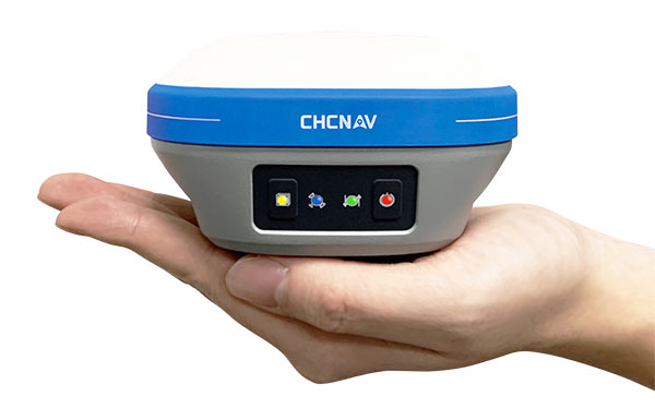
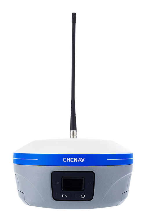
An IMU-RTK GNSS receiver that fits in your hand and a fully integrated GNSS base station add a new scale to GNSS surveying applications.
CHC Navigation (CHCNAV) has announced the immediate availability of the i73 GNSS, a versatile pocket-sized IMU-RTK GNSS rover with an integrated inertial module and the iBase GNSS, a rugged base GNSS receiver.
The combination of the i73 GNSS and the iBase GNSS offers a productive and affordable solution for measuring and staking out points in any surveying, mapping or construction application.
“Surveyors and construction professionals are forced to carry heavy and cumbersome GNSS receivers in most situations, resulting in unnecessary fatigue and lower productivity,” said Hans Huang, product manager of CHC Navigation’s Survey and Engineering Division. “Taking this into account, we have developed our pocket-sized i73 GNSS, the lightest GNSS rover powered by the latest IMU-RTK technology, and much more. Our iBase GNSS station follows the same concept of an all-in-one solution, making the need for external radio modems and other bulky accessories obsolete.”
The i73 Pocket IMU-RTK GNSS: A new scale to GNSS
The i73 Pocket IMU-RTK GNSS. (Photo: CHCNAV)
Weighing only 730 grams yet with 15 hours of operating time, the i73 GNSS is one of the lightest and most rugged RTK GNSS receivers on the market.
Easy to carry and use, the i73 will not tire out field workers. It offers superior GNSS signal tracking enables surveys beyond the usual constraints. It features full 624-channel GNSS technology and connects seamlessly to RTK GNSS networks as well as to UHF GNSS station over its embedded UHF modem.
Automatic pole-tilt compensation. The i73 GNSS internal interference-free inertial module (IMU) allows automatic pole tilt compensation of up to 45 degrees. Projects are completed 30% faster and with increased efficiency and safety when measuring hard-to-reach points.
The iBASE GNSS: Redefining the concept of GNSS base station
The iBASE GNSS receiver. (Photo: CHCNAV)
The GNSS iBase is a fully integrated GNSS base station, specifically designed to meet 95% of surveyors’ needs when working in UHF GNSS base and rover mode. The performance of the iBase UHF base station compared to a conventional external UHF radio modem is virtually identical. But its unique design eliminates the need for a heavy external battery, bulky cables, an external radio, and a radio antenna. Its 5-watt radio module provides operational GNSS RTK coverage up to 8 km.
Digital twin technology emerged a decade ago to provide 3D virtual replicas of physical assets. Today, with Big Data and internet of things (IoT) capabilities, it is a complex and comprehensive method to support the construction of smart cities.
Mapping Shanghai with the AlphaUni 900. (Image: CHC Navigation)
As a virtual model, a digital city can be an indispensable tool to visualize the life of a city in real time. It provides layered data about buildings, urban infrastructure, utilities, businesses, and the movement of people and vehicles. By providing this information, digital twins enable intelligent urban development and modernization.
Traditional methods of collecting and representing 2D spatial data, such as maps and images, are insufficient to meet the requirements for digital twin city models, where digital data provides the foundation for large-scale projects.
For example, the derived 3D models must have a high capacity to be merged and correlated with social or economic spatial data from IoT and Big Data. Because of this, a high demand exists for global, accurate, real-time geospatial data that provides high-precision 2D and 3D information.
Proof-of-concept
To illustrate a typical digital cities project, CHC Navigation (CHCNAV) carried out a proof-of-concept demonstration in the Jinshan district of Shanghai for one month in March and April.
The total area of the Jinshan district is approximately 600 km2. This area contains rich terrain features and typical characteristics of large, modern cities, such as high buildings, power lines, rivers and vegetation.
Extracted 3D mesh created from the data. (Image: CHC Navigation)
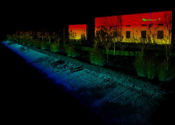
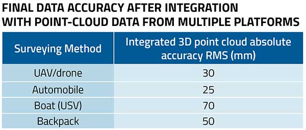
The traditional method of capturing with a single-platform lidar system may leave some areas blank in the point-cloud data. CHCNAV’s AlphaUni 900 lidar solution, with its multi-platform capability, was able to capture complete data with four different platforms: an unmanned aerial vehicle (UAV), a car, a backpack and a boat or unmanned surface vehicle (USV).
The AlphaUni series provides optimized data sets powered by advanced GNSS/inertial navigation system (INS) sensors and long-range scanners.
Point cloud from aboard an Apache6 USV mapping a water channel. (Image: CHC Navigation)
During the project, the CHCNAV AlphaUni 900 seamlessly integrated the district’s buildings in the data sets and provided a sophisticated 3D image from both indoor and outdoor environments. Its high-accuracy capability and multi-platform design can improve the way high-precision data is collected. It successfully provides an innovative solution for the problems of 3D geospatial data acquisition required for the development of smart cities.
Lidar series paired with professional drone provides multi-platform, high-accuracy 3D laser scanning for geospatial and mapping professionals
CHC Navigation (CHCNAV) has launched the multi-rotor BB4 drone and AlphaUni 300/900/1300 lidar.
Photo: CHCNAV
The combination of the AlphaUni 300/900/1300 lidar and BB4 UAV solutions creates a comprehensive and versatile range for 3D mapping and geospatial data acquisition in land, air and marine applications.
“The purchase of a 3D mobile mapping system is too often constrained to a specific purpose, such as airborne or ground survey,” said George Zhao, CEO of CHCNAV. “A lot of our customers expressed the need to have a professional lidar solution that can be used in different scenarios, offering optimal adaptability to their current and future needs.
“With our AlphaUni series, we are now introducing an innovative response with a multi-platform lidar system that can be used with an aerial or marine drone, on a vehicle or carried as a backpack,” Zhao said. “In addition, the long flight autonomy of our new BB4 UAV allows missions over large areas in a single flight for exceptional productivity.”
AlphaUni lidar series
Photo: CHCNAV
The new AlphaUni series enhances CHCNAV’s Alpha Mobile Mapping family with a light, versatile long-range laser scanner systems available on the high-end market.
The series provides optimized data sets powered by advanced GNSS/inertial navigation system (INS) sensors and long-range Riegl scanners.
AlphaUni’s design adapts to a variety of applications and can be installed on a variety of platforms, including multi-rotor UAV, fixed-wing vertical-takeoff-and-landing (VTOL) UAV, vehicles, rail trolleys, backpacks, boats and more.
BB4 UAV
The BB4 UAV is a high-end multi-rotor drone optimized for the CHCNAV AlphaUni 300/900/1300 lidar series. Its modular design simplifies deployment in just a few minutes.
Its 7-kg payload breaks the capacity barrier, and more than 45 minutes of flight time increases the airborne lidar survey ability.
The redundant CHCNAV and DJI inertial measurement unit (IMU) and GNSS units provide reliable centimeter real-time kinematic (RTK) positioning, meeting the demand for high accuracy in the geospatial and mapping industry.
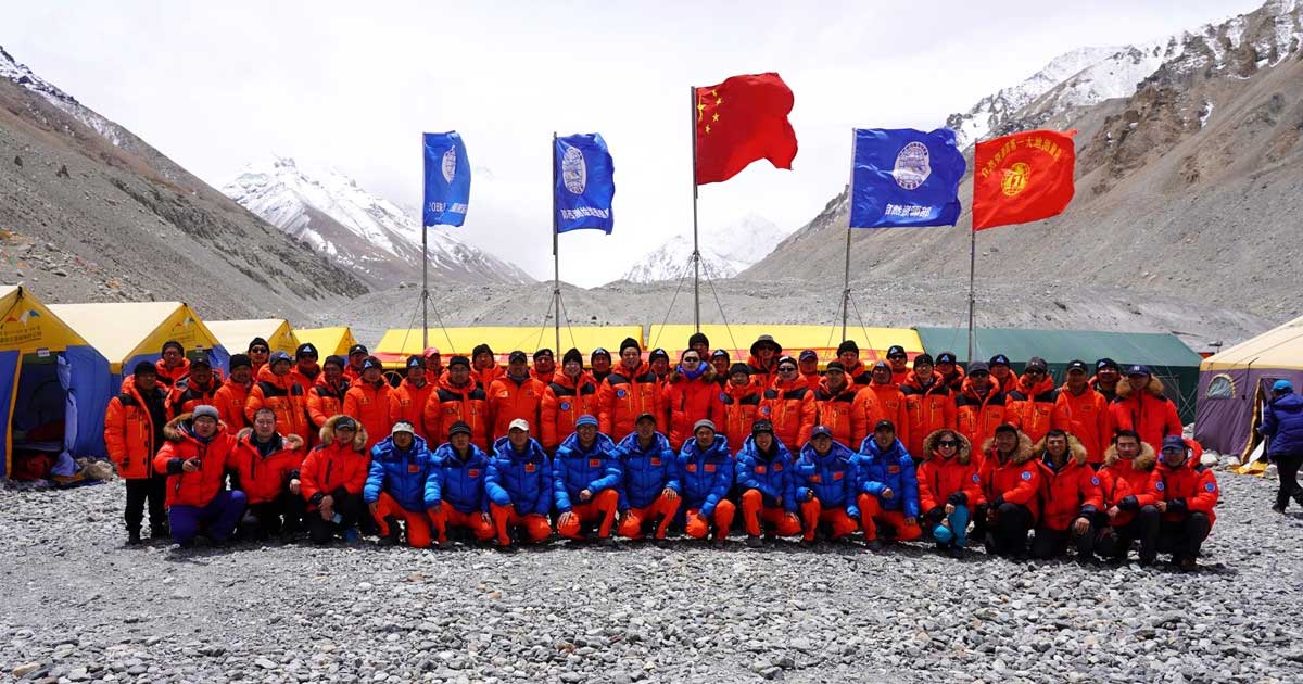
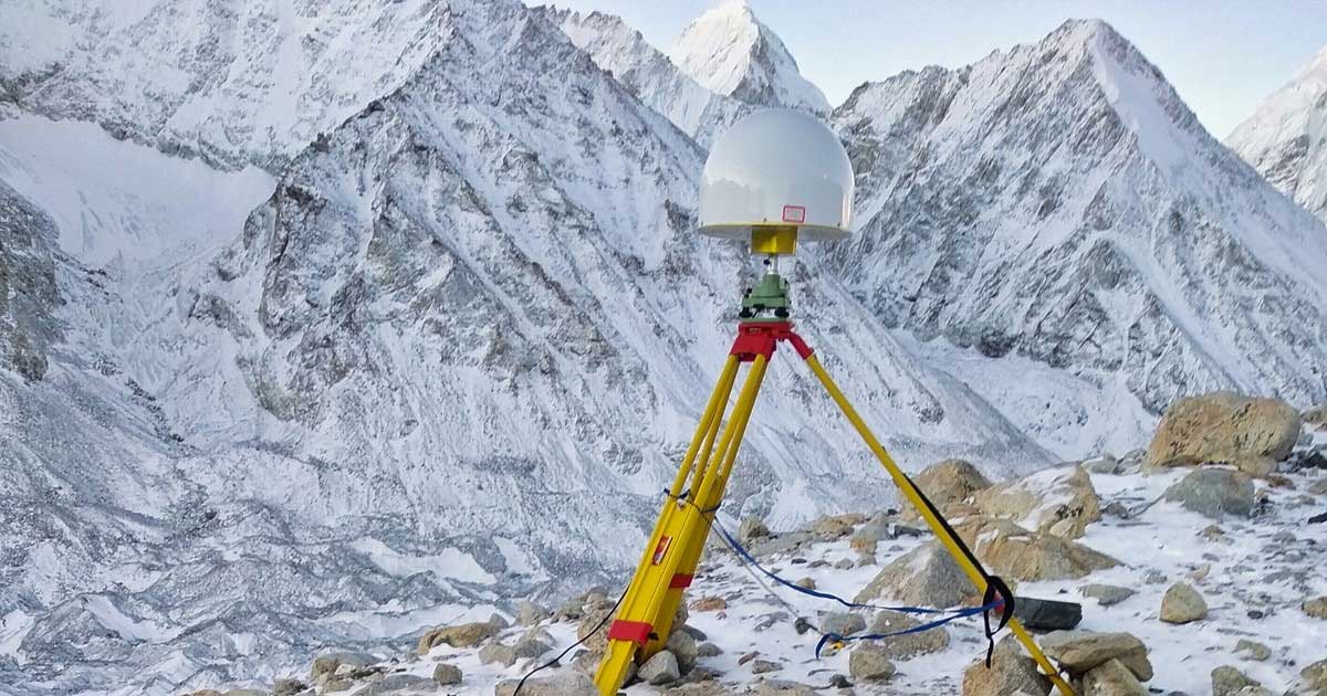
The survey team and sherpas reach the top of the world. (Photo: CHC Navigation)
China’s field work for new measurements of Mount Everest — the world’s, highest peak — are now complete. However, it will take two to three months for scientists to calculate and release its exact height, according to CHC Navigation, whose GNSS receiver was used.
The eight-member Chinese survey team reached the summit on May 27. The team erected a survey marker and installed a GNSS antenna on the snow-covered peak. The team also conducted a GNSS survey, snow depth measurement and gravity survey, said China’s Ministry of Natural Resources.
Scientists will use multiple traditional and modern measurement techniques to perform comprehensive calculations of the measurement data. After data analysis and processing, they will carry out theoretical studies and repeated verifications to determine the accurate height. Complex calculations are needed to eliminate errors caused by factors such as temperature, air pressure and the refractive environment.
CHC Navigation’s P5 geodetic GNSS receiver was successfully used by a Chinese team of surveyors to complete the 2020 Mount Everest Elevation Survey.
This is the first time that a team of Chinese surveyors has climbed the summit of Mount Everest, and it is also the first time that BeiDou-based Chinese GNSS receivers have been used to measure the height of Mount Everest, known in China as Mount Qomolangma.
China’s National Geodetic Survey Team and its Mountaineer’s Team used CHCNAV GNSS receivers. (Photo: CHC Navigation)
The Everest Project
To promote research on the Mount Everest elevation and to ensure the scientific character and accuracy of measurements, the Ministry of Natural Resources mobilized the Shaanxi Bureau of Topography and Geographic Information Mapping from the Chinese Academy of Topography and Mapping to plan and implement the measurements of the Mount Everest elevation. China’s National Geodetic Survey Team and its Mountaineer’s Team would undertake the arduous climb.
The plan set out the technical guidelines and required that the Everest Elevation Project be designed to achieve innovative and technological breakthroughs in several areas of research.
The first is to use the BeiDou satellite navigation system to perform GNSS measurements; the second is to use Chinese surveying and mapping equipment to complete the task.
Meeting Harsh Challenges
In October 2019, CHCNAV received a request from the Ministry of Natural Resources to provide GNSS equipment for the 2020 Everest Elevation Project. A dedicated team combining different departments, from R&D to manufacturing, was set up. The team elaborated the specific technical requirements from the National Survey engineers, in particular the difficulties and challenges related to the altitude of Everest.
Measuring the height of Mount Everest, especially the summit, is a challenge, not only for the limitation of the human body in such elevation environment, but also for the performance of the GNSS receiver itself.
At over 8,800 meters, the minimum temperature can reach -45°C and the atmospheric pressure is only 30 kPa (compared to the normal 101 kPa). All the surveying equipment used is exposed to both low temperature and low-pressure constraints.
In addition, the operation of the instruments must be as simple and reliable as possible in such an extreme environment. Surveyors wear thick winter clothing and lack oxygen, making every movement an extreme challenge. Finally, the measurement of the mountain peak must be completed at the first attempt, as re-measurement is impossible.
To meet these stringent requirements, CHCNAV has provided GNSS receivers that have passed the most rigorous environmental and reliability tests. The entire solution, from the GNSS receivers to the accessories, has been optimized to ensure mission success from the very beginning.
A wide temperature range of material — supporting an operating temperature range of –45°C to +85°C — were used, including redesigned lithium-ion batteries offering 12 hours of operation even at extremely low temperatures. Also used were antenna cables with a specific compound material to avoid any cracking or signal attenuation.
To ensure reliable operation of the receivers in a low-pressure environment, the GNSS receivers have built-in waterproof and breathable valves to maintain internal and external pressures. The low-pressure tests replicated a 25-kPa environment, corresponding to an altitude of 10,000 meters.
Additional ruggedized reinforcement prevented damage in the event of accidental receiver drop thanks to a robust design to keep the display and connectors safe. Following CHCNAV tests, third-party organizations were commissioned to perform environmental testing and reliability verification, including storage and operating at high/low temperatures, vibration, shock, rain, dust, humid heat, salt and fog.
From November 2019 to March 2020, CHCNAV’s GNSS equipment was supplied to the National Photoelectric Rangefinder Testing Center — under the requirements of the China Academy of Surveying and Mapping — for the most rigorous evaluation. As a result, the company’s GNSS receivers were selected to provide the peak altitude measurements of Everest in 2020.
The climb to the summit. (Photo: CHC Navigation)
Reaching the Summit
On April 5, 2020, at the Everest Elevation Survey Expedition Ceremony in Lhasa, CHCNAV officially donated GNSS equipment to the National Survey Team. Both product and technical training was provided to the team.
The 53 members of the first National Survey Team overcame the difficulties related to the environment, bad weather and the additional impact of COVID-19, and conducted a series of measurements on Mount Everest and surrounding areas such as level, gravity and GNSS.
Thirty of the 60 points of the GNSS control network were measured with CHCNAV GNSS receivers, including three of the seven Everest elevation intersection points.
On May 27, the CHCNAV GNSS receivers finally reached the summit and successfully completed the task.
The successful achievement of the Everest elevation measurement reflects the performance of the Chinese surveying and mapping industry, confirms BeiDou as a major part of the GNSS systems, and demonstrates the technical success of CHCNAV as a major player in the GNSS industry.
About CHC Navigation
Founded in 2003, CHC Navigation is a publicly listed company creating innovative GNSS navigation and positioning solutions. With a global presence across the world, distributors in more than 100 countries, and more than 1,300 employees, CHC Navigation is today recognized as one of the fastest-growing company in geomatics technologies.
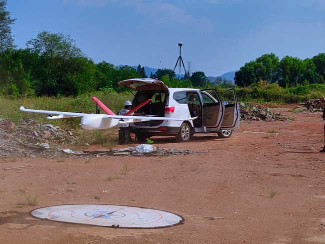
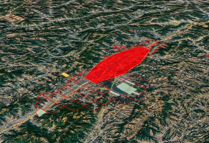
The CHCNAV P330 vertical takeoff and landing (VTOL) UAV has been deployed to complete orthophoto acquisition with a resolution of 15–20 centimeters of the city of Xichang in the Sichuan Province, China. The project involved a series of technical and operating challenges: several no-fly zones, a 700-meter flight ceiling by airspace control, tricky winds, and a total area of 900 square kilometers — all within a tight schedule.
The project involved 15 people, a fleet of four P330s and the set up of 200 ground control points.
The hybrid P330 was selected for its ability to combine the advantages of a fixed-wing UAV with extended flight time with a rotor-based VTOL UAV, which enables aerial survey missions on complex terrain.
Project area. (Photo: CHC Navigation)
Each P330s was fitted with a Sony A7R2 camera and high-accuracy GNSS positioning system. Because of its innovative design, the P330 can be assembled in less than five minutes without tools, saving the survey crew considerable time. Plus, basic operation training was completed in 2 hours.
The P330 also has one-click take-off and landing, support for breakpoint flight resuming after temporary return to base, and self-diagnostic of all sensors before take off. It has dual-rotor and parachute protection in case of emergency landing.
Other features include take-off and landing positioning accuracy within 20 centimeters and automatic return to base in case of a data communication failure. It offers survey-grade PPK accuracy.
The P330’s battery life lasts up to 2.5 hours. It will operate safely under Class 5 wind conditions at an altitude up to 4,000 meters, providing stable attitude under bad weather conditions. It also meets imaging constraints under low-light conditions.