The LBS market continues to grow strongly and with the arrival of always-on ubiquitous location, ABI Research believes that the market is ready to truly support location based advertising efforts. In Western Markets, a third generation of location-based services is now underway. It has forecast retail/shopping, ambient intelligence, hyperlocal social and personal asset tracking/BLE beacon applications to emerge as the next wave of important location based services over the next five years, with ABI Research forecasting a four-fold increase in revenues by 2019.
In emerging regions the value of location is not lost with strong local deals/offers markets already emerging. Senior analyst Patrick Connolly comments, “In Asia, ABI Research sees LBS downloads breaking 4 Billion in 2019. In China, major Internet companies can see the necessity of location and are acquiring/integrating as they move to mobile. Tencent, the Chinese Internet giant, has spent approximately $200 million to acquire an 11.28% stake in mapping company NavInfo. This follows Alibaba’s acquisition of AutoNavi. Tencent has also invested in the Chinese Yelp, Dianping, which is one of the top three players in the local deals market, which is estimated to have reached $1.2 Billion in 1Q14. Sina Weibo, which floated on the NASDAQ in April also has its own Places application.”
Furthermore, in a reversal of previous LBS application trends, ABI Research expects to see many of these companies expanding into international markets in the future. Momo is such an app, with 20 million subscribers, which is using location to go local and generate advertising revenues. It has used a round of investment to launch an English version of the application, which it hopes will enable it to expand.
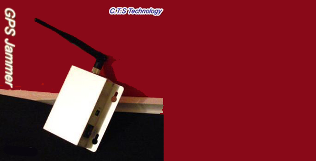
The Federal Communications Commission plans to issue the largest fine in its history against C.T.S. Technology Co., Limited, a Chinese electronics manufacturer and online retailer, for allegedly marketing 285 models of signal jamming devices to U.S. consumers for more than two years.
The FCC applied the maximum fine allowed to each jammer model allegedly marketed by C.T.S., resulting in a planned fine of $34,912,500.
“All companies, whether domestic or foreign, are banned from marketing illegal jammers in the U.S.,” said Travis LeBlanc, Acting Chief of the Enforcement Bureau. “Signal jammers present a direct danger to public safety, potentially blocking the communications of first responders. Operating a jammer is also illegal, and consumers who do so face significant civil and criminal penalties.”
C.T.S. operates a website that markets consumer electronics to individuals in the United States, where it allegedly misled U.S. consumers by falsely claiming that certain signal jammers were approved by the FCC. In fact, the use of such devices by U.S. consumers is illegal under any circumstance. C.T.S. also sold 10 high-powered signal jammers to undercover FCC personnel.
The FCC also is ordering C.T.S. to cease marketing illegal signal jammers to U.S. consumers and provide information to the FCC about any persons and entities in the United Sates that purchased its devices.
Signal jammers are radio frequency transmitters that intentionally block, jam, or interfere with authorized communications, such as cellphone calls, GPS systems, Wi-Fi networks, and first responder communications. It is a violation of federal law to market, sell, import, or use a signal jammer in the United States and its territories, except in very limited circumstances involving federal law enforcement.
The FCC is asking people to report the sale or use of an illegal jammer by contacting the FCC Enforcement Bureau through the FCC online complaint portal, or by calling 1-888-CALL-FCC (or 1-888-225-5322). To voluntarily relinquish a signal jammer, e-mail [email protected]. Additional information, including the FCC Consumer Alert on the jamming prohibitions and the FCC Enforcement Advisory to retailers regarding the marketing of illegal signal jammers, is available at www.fcc.gov/jammers.
BeiDou Releases Public Service Performance Document
In late December, director Ran Chengqi of China’s Satellite Navigation System Management Office announced the BeiDou Navigation Satellite System (BDS) Public Service Performance Standard. The document details the public service performance parameters of the BeiDou system, including service area, accuracy, integrity, continuity, and availability. It is a basic commitment to customers from BDS providers, but also an important basis for customers to choose, use, and evaluate the system performance.
Also released is Version 2 of the BDS Interface Control Document (ICD) for the Open Service Signal. Among other changes, it includes a description of the B2I signal on 1207.140 MHz.
The publishing of the Public Service Performance Standard, a common practice among GNSS operators, is also a prerequisite for BeiDou system involvement in international civil aviation, international maritime, 3rd Generation Mobile [phone] System, and other international standard-setting organization activities.
The document has Chinese and English versions. Because document download from the BDS government website can be difficult, Richard Langley has made them available at the University of New Brunswick website:
Analysis. John Lavrakas of Advanced Research Corporation posted the following comment to the online version of this news story:
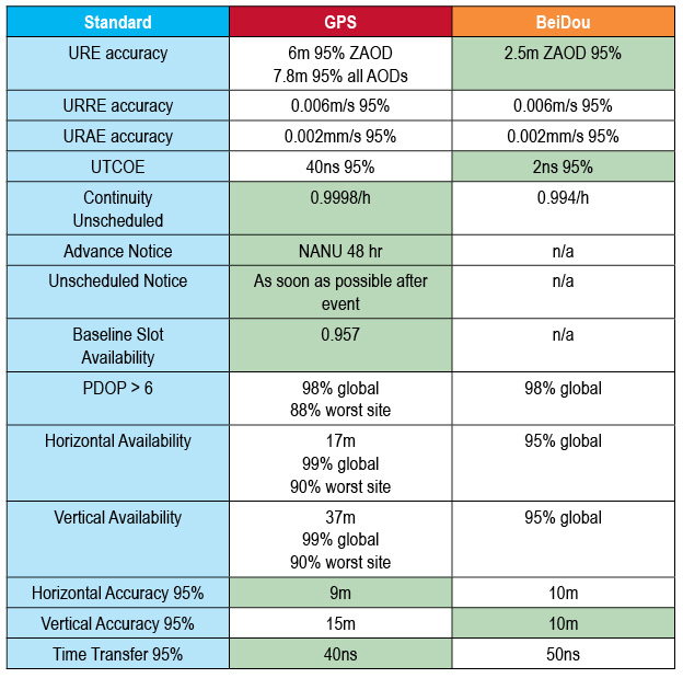
“I took a quick look at comparing the BeiDou Open Service Performance Standard with the GPS Standard Positioning Service Performance Standard and obtained mixed results.
“In some cases, the commitments from BeiDou were stronger (URE accuracy, the table to show green for the GNSS service committing to a more stringent standard over the other vertical position), and in other cases the commitments from GPS were stronger (continuity of service, advance notice of outages).
Table 1. Coded to show green for the GNSS service committing to a more stringent standard over the other. Courtesy of Advanced Research Corporation.
Galileo to Sail, Penalty-Free
Schedule Overruns Not a Problem, Avers Space Agency Director-General
Athough the European Commission (EC) sternly put in place financial penalties for late delivery and arrival on orbit of Galileo satellites, the European Space Agency (ESA) that manages the process will not suffer the consequences of a one-year delay in their launch. The EC did not sign an industrial contract with the ESA for the Galileo work, according to an announcement by ESA Director-General Jean-Jacques Dordain made the announcement in mid-January 17.
Dordain said under the agreement, the EC pays for ESA’s staff costs, while ESA acts as technical manager for the program. But the industrial contract itself to build the satellites — and specifying the penalities — was not encompassed by this agreement.
Galileo’s schedule is now firmly back on track, according to ESA,since the first OHB satellite passed thermal-vacuum testing in November, and the second satellite is in the test chamber. Signals are apparently “go” for their launch in June aboard Soyuz rocket from Guiana Space Center in South America. A second pair should launch in October, and a third in December.
Meeting an Aggressive Date. The EC committed some time ago to start initial Galileo services in 2014. Delivery on this promise has become increasingly unclear after recent testing delays. Getting new Soyuz launch dates withing this year is not a sure-fire thing, either.
The Galileo Supervisory Authority earlier announced that it had validated the four initial operating-capability (IOV) Galileo spacecraft in orbit as perform twice as well as expected in terms of signal accuracy. However, the satellites provide very limited use, about one hour per day when all are visible to the same user.
Once six satellites become visible inthe sky, sometime after the planned June launch, testing qualification of early services can begin. With eight, actual service qualification is possible but not certain. Finally, with 10 satellites — December? — early services may be able to start.
Earlier last year, EC Vice President Antonio Tajani had warned that financial penalties to those building Galileo would cover the cost overruns due to the delay in launching the system. His finger appeared to point at ESA as much as OHB AG of Germany and Surrey Satellite Technology Ltd. of Britain, who lead the industrial consortium building the satellites.
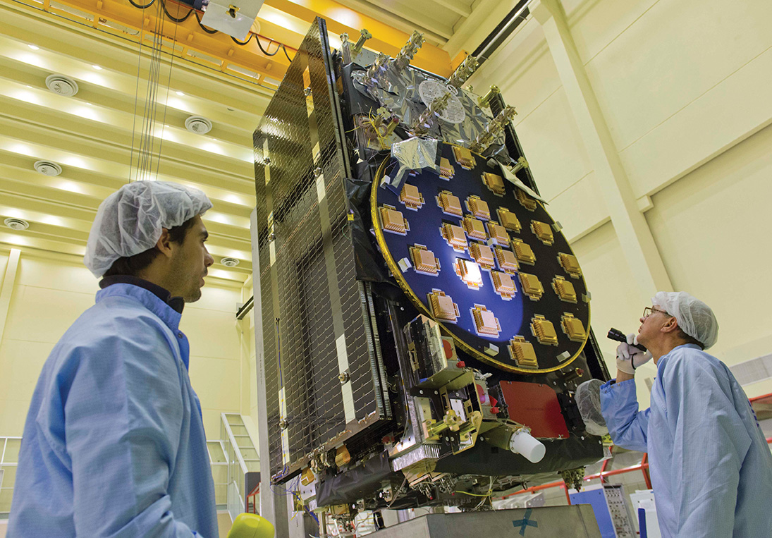
The main antenna of the second Galileo Full Operational Capability (FOC) satellite being inspected with a flashlight in advance of mass property testing at the European Space Agency’s ESTEC Test Centre in the Netherlands. Thermal-vacuum testing on the second model began in early 2014. The two FOC satellites will be launched on a Soyuz rocket from Europe’s French Guiana Spaceport in mid-2014. Whether four more can rise and begin providing initial Galileo services by the end of the year is the question of the hour.
U.S.Transport DepSec Takes Potshot at CNAV
The departing Deputy Secretary of Transportation, John Porcari, wrote a letter in the closing days of 2013 opposing the U.S. Air Force’s announced plans to begin broadcasting Civil Navigation (CNAV) message-populated L2C and L5 signals as early as April 2014. Military personnel are incensed over what they see as Porcari’s impugning, when not ignoring, the Air Force 35-year track record of broadcasting the gold standard of global navigation satellite signals — something in which Transportation has zero experience.
Porcari alludes in his December 27 letter to “non-standard engineering tools” and “non-standard operations” that he believes would come into play for early CNAV broadcast. “These have the potential to inject human error, which may result in unacceptable GPS constellation operation.”
What Porcari means by “non-standard” he does not specify, although he confesses to unease as “the ability to monitor these signals, [without which] the system will not know if the L2C and LS signals are within specification. Given these risks, DOT is concerned that the CNAV messages could provide hazardously misleading information, impacting GPS safety-of-life, protection of property, and economic security applications.” The full text of the Porcari letter is available here.
OCX Delay the Cause? Because the current GPS ground control system cannot generate CNAV, and the next-generation OCX —which can — will not be ready by April, anothercomputer will apparently develop the civil signal navigation data. However, neither the data or message is intended for actual use, nor will the FAA or any transport agency employ it. The advance project is designed to aid reciever manufaturers and developers in adpting to the new signal.
In addition to questioning Air Force 2 SOPS ability to broadcast an accurate, compliant signal containing CNAV, the letter appears to ignore — or be ignorant of — the 17 official U.S. government/military monitoring sites for GPS distributed around the world, not to mention thousands of other monitoring sites run by government agencies such as the Jet Propulsion Laboratory, the National Aeronautics and Space Administration, and the National Geospatial-Intelligence Agency, and by many universities such as Stanford, Ohio State, Cal Tech, and many other international institutions around the world. Many of these sites collaborate under the rubric of the International GNSS Service.
Finally, John Deere and Trimble Navigation both operate automated GPS signal monitoring systems that that report any anomaly in the navigation message for all GPS signals with an average two-second notification time.
“This letter is so much BS,” fumed one source who wished to remain anonymous, “coming from an agency that is in arrears in its GPS payments to the tune of more than $70 million and has no clue how to represent the global GPS user. GPS is a ubiquitous system, not just a tool for the DOT and the Federal Aviation Administration. GPS needs to implement these signals for all users and as a modernization program that was promised to be in place years ago.”
Porcari left for the private sector.
OCX Change Order to Ensure Proper M-Code Function
Raytheon Intelligence and Information Systems has been awarded a change order for work that costs up to $8.5 million on its existing contract to ensure that the new military signal, M-code, works with the GPS Operational Control System, according to an announcement from the Pentagon as reported by Space News.
Raytheon is building the ground station (OCX) for a new generation of satellites that will bring more safety and precision to GPS. The contract modification is to assure implementation of M-code capabilities across OCX Block 1 and 2. M-code is the new highly secure, anti-jam signal designed for the GPS III constellation. The current GPS ground control system lacks M-code capability.
The OCX is designed to work with the advanced GPS III positioning, navigation and timing satellites, slated to start launching in 2015, and also will be backwardly compatible with existing GPS satellites.
Raytheon won the $886.4 million prime contract to develop the OCX in February 2010. Work will be performed at Raytheon’s facility in Aurora, Colorado, and is expected to be completed by August 31, 2016.
The Air Force Space and Missile Systems Contracting Directorate, Los Angeles Air Force Base, California, is the contracting agency.
Details. Raytheon Intelligence and Information Systems, Aurora, Colorado, was awarded the unpriced change order (P00112) with a not-to-exceed of $8,595,748 on an existing contract (FA8807-10-C-0001) for M-Code Implementation on the Operational Control System. The contract modification is to assure implementation of M-Code Capabilities across OCX Block 1 and 2. Work will be performed at Aurora and is expected to be completed by August 31, 2016. Fiscal 2014 research and development funds will be obligated at definitization.
GAGAN Certified for Aviation over India
The Director General of Civil Aviation of India has certified the GPS-Aided Geo Augmented Navigation (GAGAN) system to Required Navigation Performance 0.1 Nautical Mile (RNP0.1) service level.
Aircraft equipped with satellite-based augmentation system (SBAS) receivers can now use GAGAN signals in Indian airspace for en route navigation and non-precision approaches without vertical guidance.
Mission control centers and uplink stations now operate on Indian soil. Messages carrying corrections to GPS signals are sent to satellites in geostationary orbit carrying the GAGAN payload.
The availability of the GAGAN signal over Indian airspace bridges the gap between European Union’s European Geostationary Navigation Overlay Service (EGNOS) and Japan’s Multi-functional Satellite Augmentation System (MSAS) coverage areas.
The SBAS consists of 15 Indian reference stations, three uplink stations, three mission control centers, and three GAGAN payloads broadcasting in C and L bands and with all the associated software and communication links.
GAGAN will provide augmentation service for GPS over India, the Bay of Bengal, South East Asia and the Middle East expanding up to Africa.
Car, Nav Makers Emulate NSA: Track, Store Consumer Data
U.S. Big Three automakers and some Japanese car companies track and store data from customers’ on-board navigation systems, according to a report from the U.S. Government Accountability Office. The document describes, in general fashion, practices at General Motors, Ford, Chrysler, Toyota, Honda, and Nissan, and further delves into data storage by GPS manufacturers Garmin and TomTom and nav app designers Google Maps and Telenav.
The GAO said the automakers collect data at times to assist customers with traffic updates, emergency roadside assistance, and to track stolen vehicles.None of the companies currently sell the data, according to the report, but most drivers do not know what information is being tracked and cannot opt out of the data collection programs.
The companies can “track where consumers are, which can in turn be used to steal their identity, stalk them or monitor them without their knowledge. In addition, location data can be used to infer other sensitive information about individuals such as their religious affiliation or political activities.”
The report claims the companies’ privacy policies are sometimes unclear, making it difficult for consumers to understand the potential risks of using their GPS navigation devices.
No federal law regulates GPS privacy; it is not illegal for private companies to collect, use, or sell personal information. Several proposals have been floated in Congress to protect the privacy of GPS data, but none enacted.
China’s BeiDou system claimed a user range error (URE) of 2.5 meters zero age of data (ZAOD) 95% recently. The parallel GPS specifications commit to 6 meters 95% ZAOD and 7.8 meters 95% all AODs. Does this mean that BeiDou is more accurate than GPS? Not so fast.
In late December, director Ran Chengqi of China’s Satellite Navigation System Management Office announced the BeiDou Navigation Satellite System (BDS) Public (or Open) Service Performance Standard. The document details the public service performance parameters of the BeiDou system, including service area, accuracy, integrity, continuity, and availability. It is a basic commitment to customers from BDS providers, but also an important basis for customers to choose, use, and evaluate the system performance.
A few important qualifications of BeiDou’s performance standard first:
According to the foreword of the document, “This document specifies the BDS open service performance standard at the current stage.” This is as it should be.
A paragraph on service volume, however, highlights the fact that BeiDou is as yet a regional service.
“4.4 BDS OS Service Volume
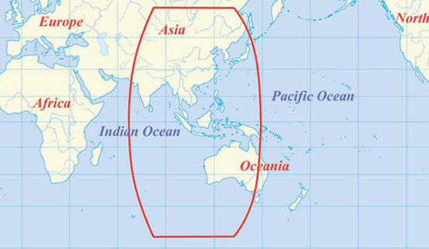
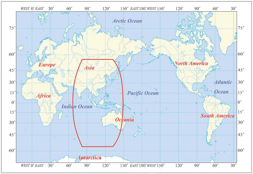
The BDS OS service volume is defined as the OS SIS coverage of the BDS satellites where both the BDS OS horizontal and vertical position accuracy are better than 10 meters (probability of 95%). At the current stage, the BDS regional service capability has been achieved, which can provide continuous OS to the area as shown in Figure 2 & Figure 3, including the most part of the region from 55°S to 55°N, 70°E to150°E.”
The BDS Service Area.
This means that BeiDou commits to 2.5 meter accuracy in China, as well as neighboring countries — and importantly, trading partners — in Southeast Asia plus Australia.
Does this mean that once BeiDou attains global status, it will provide 2.5 meter accuracy everywhere, on its basic single frequency, open service? Hard to tell. Much of its strength, its core strength, one might say, comes from 5 geostationary Earth orbit (GEO) satellites and 5 Inclined Geosynchronous Satellite Orbit (IGSO) satellites. The GEOs hover over the Equator more or less permanently, south of but in the general longitude of China’s sovereign national territory. The IGSOs move back and forth from the northern to the southern hemispheres in the same area.
When BeiDou achieves its planned global reach, an event scheduled for 2020, the constellation will consist of 35 satellites: 5 GEOs, stationed at longitudes so their footprints cover China, 27 medium Earth orbit (MEO) satellites encircling the globe in continuous paths as do those of GPS, and 3 IGSOs over the East and Southeast Asian regions.
Will globally available accuracy at that point match what is achievable in China? It takes a better geometric mind than mine to fathom this.
Even disregarding the geographic limit of the 2.5-meter claim, and ignoring for the moment the mathematical conundrum outlined above, there are reasons to scrutinize the BeiDou Performance Standard more closely, as John Lavrakas of Advanced Research Corporation has done. His notes, and an illuminating table, follow below after a bit more introduction and background on the general topic.
The publishing of the Public Service Performance Standard, a common practice among GNSS operators, is also a prerequisite for BeiDou system involvement in international civil aviation, international maritime, 3rd Generation Mobile [phone] System, and other international standard-setting organization activities.
The document has Chinese and English versions. Because document download from the BDS government website can be difficult, Richard Langley has made them available at the University of New Brunswick website:
John Lavrakas of Advanced Research Corporation posted the following comment to the an earlier online article announcing the Performance Standard document.
“I took a quick look at comparing the BeiDou Open Service Performance Standard with the GPS Standard Positioning Service Performance Standard and obtained mixed results.”
Table 1. Coded to show green for the GNSS service committing to a more stringent standard over the other. Courtesy of Advanced Research Corporation.
“In some cases, the commitments from BeiDou were stronger (URE accuracy, vertical position), and in other cases the commitments from GPS were stronger (continuity of service, advance notice of outages).
“The good news is that GNSS systems are documenting the service levels that users can expect. What we will need next is monitoring to verify these service levels are being met.
A final note. As the GPS stewards from the U.S. Air Force carefully and proudly remind us at each GNSS conference where they deliver a briefing, actual GPS performance has almost always bettered its specs over the last decade or two — often by a considerable margin.
And with that, I think we may all return to our various pursuits, secure in the knowledge that while the gold standard may — repeat, may — at times pass in limited special circumstances or under particular conditions, from system to system, overall GNSS Things Are Getting Better All the Time.
On December 27, 2013, the first anniversary of BeiDou Navigation Satellite System providing full operational regional service was held in Beijing. At the meeting, China Satellite Navigation System Management Office Director Ran Chengqi announced the BeiDou Navigation Satellite System Public Service Performance Standard.
The document details the public service performance parameters of BeiDou system, including service area, accuracy, integrity, continuity, and availability. It is a basic commitment to customers from BeiDou system providers, but also an important basis for customers to choose, use and evaluate the system performance.
Also released is Version 2 of the BeiDou Navigation Satellite System Interface Control Document (ICD) for the Open Service Signal. Among other changes, the new version now includes a description of the B2I signal on 1207.140 MHz.
The publishing of the Public Service Performance Standard is a common practice in the world satellite navigation system suppliers, and also a prerequisite for BeiDou system involvement in international civil aviation, international maritime, 3GPP and other international standard-setting organization activities. Further, it is meaningful for the promotion of international cooperation and application of the BeiDou system in the aviation, maritime and mobile communication areas, according to the China Satellite Navigation System Management Office.
Hello, everyone, I am looking for a tool/software which can generate a satellite geometry distribution map of Chinese BeiDou over Asia. Just like a GPS PDOP global map. Could anyone give me a help? Thanks a lot in advance.
We use this tool to plot satellite coverage: www.agi.com/
We have a standard mission planning tool that can do it (GPS, GLONASS, Galileo and BeiDou) and is included with our post-processing software, called EZSurv. If you’re interested to try the planner, I can send an evaluation copy of it.
You can use the (free!) Trimble online Planner (www.trimble.com/GNSSPlanningOnline/#/SatLibrary). Supports GPS, GLONASS, Galileo, BeiDou, QZSS. There was an offline tool available, too, but can’t find it anymore. Really helpful tools, thanks Trimble!
We at GMV have our own Service Volume Simulator, named polaris (www.gmv.com/en/space/Polaris/). polaris has been (and is being) extensively used in the Galileo and EGNOS programmes.
From the CANSPACE Discussion Group (ListServ)
I’d like to view broadcast SV health data that is accurate to the minute. When I use IGS stations, I can only find health data in nav files to the resolution of two hours. Could someone point me to where I could find SV health data with the granularity of 1 minute or better?
Comments
Some IGS stations stream data, including ephemerides, in real time. Presumably, any change in SV health would be reflected in an updated ephemeris. Real-time ephemeris data from the global network is provided on available Ntrip streams. Georg Weber (the scientific director in the Department of Geodesy at the German Federal Agency for Cartography and Geodesy (BKG) and a member of the IGS Real-time Working Group and the Radio Technical Commission for Maritime (RTCM) Services Special Committee (SC) 104 on Differential Global Navigation Satellite Systems (DGNSS)) kindly supplied this information:
“If I understand things correctly, then an updated navigation message is disseminated immediately when GPS operators become aware of a problem and that this is the only real-time source of information regarding SV health coming directly from the system. Hence real-time access to RTCM broadcast ephemeris messages is what you are asking for. Here is how to get it:
Pull stream RTCM3EPH for a few seconds and convert its contents to RINEX2 or RINEX3 navigation files.
Stream RTCM3EPH contains only broadcast ephemeris for GPS and GLONASS as received from the global real-time IGS network — no observations. The broadcast ephemeris repetition/update rate is 5 seconds.”
The Navigation message is only updated every two hours (currently) so the granularity you require is not possible, as the health flag is an official designation from the GPS control center. The fastest changing navigation files are in the IGS Data centers called “hourDDD0.13n” for example, for today here: ftp://cddis.nasa.gov/gps/data/hourly/2013/318/hour3180.13n.Z
This file gets updated hourly (or more) with the contributions from the navigation files of the IGS network.
A faster way of noting changes would be to monitor several worldwide data real-time streams from public stations using the BNC software to monitor the health flags, but while the data will come in real-time the changes in flag status only take place every two hours, but at least you will see a health flag change very quickly. Check out:
By Chengqi Ran, Director General of the China Satellite Navigation Office
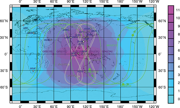
By adhering to the principles of independence, openness, compatibility, and gradualness, China has steadily pushed forward the deployment of the BeiDou Navigation Satellite System (BDS), following a planned three-step strategy. In 2000, BeiDou Navigation Satellite Demonstration System was completed. By December 2012, five geostationary orbit (GEO) satellites, five inclined geosynchronous orbit (IGSO) satellites, and four medium-Earth orbit (MEO) satellites had been launched, forming the constellation, and formally beginning service provision to the Asia-Pacific region.
The important contribution of BDS for Chinese and global users is well-recognized. It will provide services to global users by around 2020.
System Deployment
Moving forward in 2014, additional satellites will be launched to form the next constellation, while regional service performances will be advanced and expanded to worldwide scope. Approximately 40 satellites in total will have been launched by about 2020.
Current System Performance
Single-frequency horizontal, vertical, and three-dimensional positioning accuracy has been achieved at levels better than 10 meters, 10 meters, and 14 meters, respectively. Timing accuracy is better than 50 nanoseconds. Velocity accuracy is better than 0.2 meters per second. Carrier-phase differential accuracy is about 2–3 centimeters. During the past year, BDS has been continuously improved and enhanced, while its service performances in some regions dramatically surpassed the indicators given earlier.
Application Promotion
The application of BDS has played an important role in China, especially in advancing science and technology. Chinese scientists and engineers have intelligently and enthusiastically embraced China’s independent navigation satellite system and have made great progress in research and development of navigation satellite technologies, as well as new breakthroughs in the production of navigation chips, antennas, terminals, and integrated services.
In 2012, the total output value of China’s satellite navigation and location-based service (LBS) industries reached 81 billion renminbi (RMB, equivalent to $13.2 billion), which amounts to 8 percent of the global sector. At the end of 2012, BDS civil user terminals totaled 230,000 units, and BDS-related industrial output value was close to 4 billion RMB ($652 million), which is about 5 percent of the national output.
A series of policies aimed at strengthening the application of satellite navigation are under formulation in China, and the Mid- and Long-Term Development Plan for the National Satellite Navigation Industry has been issued. Satellite navigation has become one of the emerging industries with strategic importance. BDS is propelling China’s satellite navigation and LBS industries into a new era.
Distribution of visible in-orbit BeiDou satellites.
International Cooperation
China upholds and adheres to the concept of “BeiDou is of China, and also of the world,” advocating compatibility and interoperability among navigation satellite systems, and endeavoring to stimulate global widespread use of navigation satellite systems. To enable users to enjoy more reliable and ensured satellite navigation services, BDS has joined in international GNSS monitoring and assessment cooperation, making use of global monitoring stations, sharing international monitoring statistics, implementing joint assessment studies, and striving to offer trustworthy monitoring and assessment data and products to users.
To achieve BDS’ envisioned coverage area more quickly, the BeiDou+ Application Demonstration and Experience Campaign (BADEC) has been initiated. “BeiDou’s tour to the Asian-Pacific region” and “BeiDou’s tour to the ASEAN” have been kicked off to accelerate application promotion of navigation satellite systems in many countries. To popularize satellite navigation technologies, particularly enhancing its recognition and application in developing countries, BDS has provided academic education, short-term training, and thematic lectures with support from International GNSS Exchange and Training Center.
China also holds the annual China Satellite Navigation Conference, actively participates in international exchange activities on satellite navigation, and engages in academic exchanges, high-level forums, and popularization of knowledge.
Future Outlook
BDS is also committed to:
establishing navigation-satellite augmentation systems in the Asia-Pacific region and worldwide, developing better service performances, to provide decimeter-level accuracy in real time and centimeter-level accuracy after post-processing;
setting up satellite-navigation products-quality testing certification centers;
speeding up formulation of standards and intellectual property rights;
joining international organizations such as the International Civil Aviation Organization (ICAO), International Maritime Organization (IMO), and Third-Generation mobile communication standard Partnership Project (3GPP);
strengthening compatibility and interoperability with the other navigation satellite systems;
promoting BDS/GNSS applications in transportation, energy, power, finance, telecommunication, disaster reduction and relief, and so on, to realize the BDS objective of serving the world and benefiting mankind.
BDS will fully exploit the unique advantages of navigation, communication, and augmentation integration, enhance its short message service (SMS), and providing faster positioning and timing capabilities. BDS will also effectively integrate satellite- and ground-based augmentation systems, and insist on implementations of compatibility and interoperability among multi-GNSS, to enable its organic integration with mobile communication, LBS, and the Internet, and provide better quality, more reliable and efficient services to eco-social development, public security, and individual users.
Chengqi Ran is the director general of the China Satellite Navigation Office and press spokesman of BeiDou Navigation Satellite System. He graduated from Tsinghua University with a Master’s degree in industrial engineering, and previously was director of the General Technology Department in the China Satellite Navigation Project Center.
Along with booming auto sales in China has come an increase in auto accidents, which has been a headache for the Chinese government. According to police statistics, most of the accidents in the past couple of years were being caused by new drivers, who have been ignominiously dubbed “road killers.”
One year ago, the China Police Ministry decided to change the method of licensing new drivers by using stricter methods for training and testing. The new system also was designed to avoid cheating.
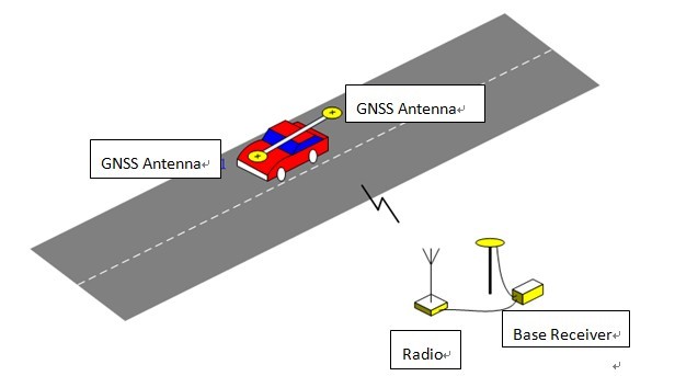
Under to the new testing system rules, the high-accuracy GNSS receiver became the ideal sensor to enforce the new testing, according to ComNav, a ShangHai-based OEM receiver maker. By offering a turnkey solution, from November 2012 to July 2013 ComNav sold more than 5,000 GNSS OEM boards/receivers for driver testing — the major share of that market.
The system uses the real-time kinematic (RTK) method to establish the accurate heading and position of the car, with a ComNav M600 GNSS receiver. A base station sends differential data to a rover installed on the car. With the help of 3G or Wi-Fi, the real-time data is transmitted to the control center. Examiners can then can judge whether the car is in the right area. Both the trainee and system will know the testing results without delay.
Surveying the testing place, marking the testing area, and measuring the car shape need to be done before the installation.
ComNav Technology Ltd. is a high-accuracy positioning solutions supplier that focuses on high-accuracy GNSS core technology R&D, manufacturing and marketing. ComNav is the first Chinese high-accuracy GNSS OEM board manufacturer and producer of a GPS+BeiDou OEM board.
System diagram. Source ComNavSide parking test. Source ComNav
I recently attended the Fourth China Satellite Navigation Conference (CSNC, held May 15–17 in Wuhan, China), as an invited speaker and panelist. I had attended the third CSNC last year in Guangzho, and as expected this year’s was a little bigger and a little better. The Chinese GNSS industry is growing quickly, as evidenced by the more than 2000 attendees with as many as 10 simultaneous sessions at some times, with more than 200 presentations over three days, and nearly 150 exhibitors on the show floor. The conference is mainly attended by Chinese, but they are working hard to attract an international audience by providing simultaneous translation of all presentations, and dual-screen projection for slides in English and Chinese if the author chooses.
I couldn’t possibly see everything, so I chose to spend most of my time in a series of sessions on industrial policy, regulations, standards, and intellectual property. I thought those sessions would provide the most unique information this conference had to offer. I expected to hear a lot of standard or official position statements without much audience discussion, but I was pleasantly surprised by the level of information from personal experience that the speakers offered and the amount of lively debate that often followed the presentations. The simultaneous translation was essential and not only allowed me to follow but created the opportunity for multi-language Q&A which allowed more complex questions to be asked.
I was particularly interested in understanding what changes were going to occur since the full release of the BeiDou Interface Controld Document (ICD) in December. One thing I noticed right away is that the term Compass has pretty much gone away. The official name, and what everyone used in their presentation, is BDS. I am not quite sure I follow the methodology, but it’s an abbreviation for the BeiDou Satellite System. I would certainly recommend to anyone meeting with Chinese business associates that you appear very up to date by using BDS instead of Compass in all your presentations, oral, written or PowerPoint.
The changing of the official name is just the first ripple in what I expect will be a wave of changes in the BDS industry (see, I learn fast). One of the most interesting talks was given by Hua Xu, whose affiliation was given in the English program as “BDS specific policies and regulations expert team, ex-director of the policy and regulations Division of Development and Reform Commission.” His talk was entitled “Thoughts of perfecting China’s BDS Industry System Construction.” He related several interesting anecdotes about the history of the satellite program, going back many years, all the way to the Cultural Revolution of the 1970s. As an example of how different the Chinese setting is for legal issues, he told us that in China, if a car hits a pedestrian, the car driver has to pay damages regardless of fault, because since he is driving the car, and the car damaged the pedestrian, he must accept responsibility. Mr. Xu spent more time talking about how China’s GNSS industry must grow in terms of industrial capability, intellectual property, and mass production, and how the government is encouraging that growth.
To date, that growth has been very rapid, as embodied by a vast array of small companies focusing on domestic Chinese applications of BDS, in particular in survey and mapping and in search and rescue. The growth impetus now moves to the automotive sector, where there is continued investment by both the national government and regional governments to promote the use of BDS in transportation projects involving trucks, taxis, and government vehicles. Some may view this as protectionist, due to the approved vendor lists and subsidies that are provided, but I think it is just a natural effort to create local centers of excellence and jobs in a new technology; this process occurs all over the world. The companies that are in this business are the 150 or so who exhibited on the CSNC show floor, and they are the little tigers of my title.
Most of the names of the little tigers are not that familiar outside of China: unicore, BDstar, Olinkstar, and many more. They have developed their own GPS+BDS chips and are selling them in moderate quantities of thousands for domestic customers. At CSNC, they presented lots of results that clearly show the advantages of multi-GNSS (GPS+BDS) within today’s BDS regional coverage area. Furthermore, the accuracy and time-to-first-fix performance of their solutions is comparable to the overall market. However, as market needs in China grow from thousands of units to millions of consumer devices, the little tigers are not quite ready yet to support the Lenovos (computers), HTCs (smartphones) and Huaweis (mobile phones and tablets).
But China wants to see BDS in all those consumer devices, to demonstrate to the world the benefit of BDS; hence the ICD was released in December. The ICD release opened the gate to China’s domestic market that previously was solely hunted by the little tigers. The wolves were waiting at the gate and they have charged in. Broadcomm, CSR, Trimble, NovAtel, and others have already publicly announced BDS support in their mainstream products, in the first few months following the release.
This was the topic of the discussions in CSNC that were most revealing for a foreigner like me to hear. I was ready to ask the tough question of what the future holds in the consumer market, because I figured no one else would. But much to my surprise, the moderator of the session put up a slide that translated to: “B1 ICD was released while Regional System is officially operational, will affect domestic BDS receiver industry? Pros? Cons?” (See opening photo.)
The ensuing discussion was quite lively but polite on both sides of the issue. Would subsidies continue for domestic suppliers? How could local companies hope to attract investment to scale up with international competition? Where could Chinese companies carve out intellectual property to protect their inventions? What could that government really do without running afoul of the World Trade Organization?
Many more questions were raised than answers arrived at, and I think most of the really interesting discussions took place away from the microphones and the simultaneous translation. So I cannot provide them for you.
Even without answers, the act of discussion was enlightening. I think the fact that these discussions are happening in public forums indicates the growth and transformation of Chinese society. There were finance people, engineers, businessmen, government regulators, all debating a difficult topic.
I don’t know the answers, but the little tigers know that the wolves are coming. And they are not running in fear. The openness of the internal debate within China indicates that the little tigers are working on a new plan, and no one should assume that the wolves are going to win. The competition in the domestic Chinese market — the very largest market, by far, of any in the world — is going to be very interesting over the next few months and years.
Greg Turetzky is a principal engineer at Intel responsible for strategic business development in Intel’s Wireless Communication Group focusing on location. He has more than 25 years of experience in the GNSS industry at JHU-APL, Stanford Telecom, Trimble, SiRF, and CSR. With this issue, he joins GPS World’s Editorial Advisory Board.
The statements, views, and opinions presented in this article are those of the author and are not endorsed by, nor do they necessarily reflect, the opinions of the author’s present and/or former employers or any other organization the author may be associated with.
The chief designer of the BeiDou Navigation Satellite System said China will advocate the use of the system, which will be compatible with new devices, “so that Beidou can function properly and independently even if something goes wrong with the GPS.”
Sun Jiadong, chief designer of BDS and an academician of the Chinese Academy of Sciences, made his comments in an interview with The Beijing News, as reported by the Chinese government’s website.
He added that this compatibility is the only way to ensure the protection of national information. “Safety issues abound in economic areas,” said Sun. “Ordinary people may have few concerns about the security of information but it is of vital significance.”
The development of Beidou also largely depends on the government’s involvement. “Even though the enterprises spare no effort in developing the system, the products they make would not be available for mass production, which will in turn be reflected by the prices. The government has to promote the research and development of the system,” Sun said. Sun cited the governments of Beijing, Shanghai, and Guangzhou as examples of local governments that were effectively helping to develop the BDS.
The use of Beidou could go beyond basic navigation functions and extend to the civilian market. It would take longer for the BDS to be available for civilians, said Sun. The use of Beidou on mobile phones relies on the development of a small and power-efficient chip. Otherwise the phone cannot be used.
When asked about when and how the cost of developing the BDS will be recovered, Sun reiterated that Beidou was developed to ensure the security of national information, and not to make profits.
The Beidou global navigation system will be available by 2020 with the launching of more than 30 satellites.
CSR plc today announced that its SiRFstarV, SiRFprima and SiRFatlas location platforms are now able to acquire and track satellites and utilize location data from the recently activated BeiDou Satellite Navigation System.
The addition of the BeiDou constellation is part of CSR’s ongoing efforts to support all global navigation satellite systems as they become available, with software or firmware upgrades, for greater performance and enhanced compliance with existing and future requirements of national GNSS systems, the company said.
“CSR is committed to supporting all current and future GNSS constellations with its location platforms to boost location performance by increasing service availability, reducing observation time and making measurements more precise for the most demanding applications,” said Dave Huntingford, director of marketing for location at CSR. “With the addition of these new satellites, our location platforms can now actively utilize GPS, GLONASS, QZSS and SBAS, in addition to BeiDou-2, and they are ready to support Galileo as soon as it becomes available to provide continuous location awareness and the best location-based services experience.”
Rob Yeh, director of product marketing for Automotive SoC at CSR, added, “All CSR’s latest multi-GNSS location platforms, including CSR SiRFatlasVI and SiRFprimaII, are now able to demonstrate live BDS (BeiDou System) navigation, and CSR will include BDS support in all future-generation location platforms. Besides providing flexibility and improved satellite acquisition and location tracking in challenging situations like urban canyons, the BeiDou support also improves CSR’s already industry-leading dead-reckoning technologies.”
CSR maintains an experienced development team in mainland China to develop and support BeiDou-related products and technology.
Also known as Compass and BeiDou-2, the Chinese BDS started operations in December 2012 and has 14 active satellites in service over the Asia-Pacific region available to general users. When fully deployed by 2020, BDS is expected to comprise a total of 35 satellites offering complete coverage around the globe.
SINA Corporation, an online media company serving China and the global Chinese communities, and AutoNavi Holdings Limited, provider of digital map content and navigation and location-based solutions in China, have jointly announced a strategic partnership to integrate and enhance each other’s social, location and mobile offerings.
As a result of this partnership, AMAP, AutoNavi’s mobile map application, users will be able to sign on using Weibo Connect and access content directly from SINA Weibo. SINA Weibo users will also have access to the content and functionality of AMAP. The companies expect such content and product integration will enhance the social networking and navigational aspects of each other’s mobile offerings.
“Over 70% of SINA Weibo users access the social media platform at least partially via mobile devices,” said Gaofei Wang, vice president and general manager of SINA Mobile. “LBS (location-based services) and mapping services will play a key role in Weibo’s mobile strategy, and we are excited to be partnering with AutoNavi to leverage their expertise in these areas.”
“In teaming up with Sina, we are proud to provide our mapping and location-based services to more than 400 million Sina Weibo users, while at the same time integrating Sina Weibo’s social content and SNS features into AMAP,” said Congwu Cheng, chief executive officer of AutoNavi. “We believe our collaboration with Sina Weibo will benefit both of our users and we look forward to future cooperation between our two companies as we continue to bring new features and functionalities to our users.”