China’s BeiDou navigation industry in 2025 achieved a total output value of 1.33 trillion yuan (US$195 billion), according to a report released Monday by the GNSS and Location Based Services (LBS) Association of China, or GLAC, reports CGTN.
The BeiDou industry includes remote sensing and geographic information systems (GIS), mobile communications and indoor positioning. The satellite navigation sector generated 629 billion yuan (US$92 billion) in 2025, up 9.24% year on year, according to the report.
China has established a complete BeiDou industrial chain and supply chain, covering chips, modules, antennas, terminals, system integration and application services, , according to the report. Domestic capabilities are becoming increasingly self-reliant, with the cumulative shipments of BeiDou-compatible chips and modules reaching hundreds of millions, supporting a secure and robust industry supply chain.
Domestic sales of BeiDou-enabled terminals exceeded 410 million units in 2025, with more than 2.2 billion BeiDou-capable devices in use across the country.
Internationally, BeiDou services and related products have been exported to more than 140 countries and regions.
A ceiling fan slowly churned, stirring the hot, humid air. Outside, warm rains pelted the muddy streets as distant langurs whooped in the thick jungle mists below.
An incessant fly caught the attention of the office’s lone occupant, hunched over a table covered with a large grid-lined sheet of paper. Pencils, erasers, French curves and straightedges lay scattered next to a stack of calculation sheets, but the man holding a pencil in one hand gripped a rolled newspaper in the other, intent on his battle with the fly.
Suddenly, the door burst open.
“Mr. Waugh!” the intruder exclaimed, panting as he rushed in.
“Radhanath,” Waugh replied in surprise, looking up from his maps. “I thought you were in Calcutta, 1,600 km away.”
“Yes, Mr. Waugh, I was, but this is too important to deliver by post.”
“Really, Radhanath. You intrigue me,” replied Waugh. “Come out with it. Your excitement is adding to this already unbearable heat.”
“Sir,” Radhanath tried to say calmly. “I have discovered the highest mountain in the world!”
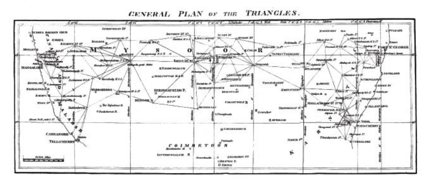
That conversation happened in 1852. It was the crown jewel of an effort that began 50 years earlier. Britain was on the ascent. Surveying was the mathematics of empire. India, Britain’s largest protectorate, had never been systematically mapped. The British East India Company needed to know what minerals, crops and commodities could be turned into profitable enterprises, where they were, and how to move them to ports. This depended on accurately mapping India. Infantry officer William Lambton proposed an audacious solution: measure the entire subcontinent with triangles.
William Lambton
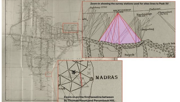
Lambton was granted the commission, and on April 10, 1802, the Great Trigonometrical Survey (GTS) of India began with a humble but critical baseline from St. Thomas Mount near Madras, 12 km south to Perumbauk Hill. Everything depended on the accuracy of this first baseline: even the smallest error would multiply as triangles spread across the subcontinent. Perfection was essential. The distance was measured with a 100-ft steel chain protected from the sun beneath A-frame tents to prevent thermal expansion. It moved slowly, 100 ft at a time from start to finish. Every link mattered. The baseline took 57 days.
To guarantee perfect alignment, Lambton relied on a massive custom-built theodolite. It weighed 1,102 lbs, requiring 12 men to carry. Surveyors planted stakes, stretched strings, and used the theodolite to correct for every change in elevation, turning a simple chain measurement into the geodetic foundation of the entire survey.
Time marched on faster than the survey. The East India Company estimated five years, but by 1818, the survey reached west to Mangalore and north to Hinganghat. It was too slow. Lambton’s vision of “an uninterrupted series of triangles…from sea to sea…to an unlimited extent in every other direction,” a complete geometric quilt covering India, proved implausible. Malaria took its toll. Lambton’s health declined and in 1823 he died at Hinganghat. George Everest inherited the survey.
The map of triangles covered Madras to Mangalore.George Everest
Everest recognized Lambton’s dream of total coverage would take centuries. Instead, he conceived a “gridiron” of chains running north–south and east–west, intersecting at right angles, scaffolding to which localized surveys could be tied. The shift is evident on the GTS map: dense triangulation in south-central India reflects Lambton’s ambition, while the more open, structural network elsewhere reveals Everest’s pragmatism.
By the 1830s, Everest’s survey party had grown into slow-moving caravans, reaching as many as 1,000 people at peak times. Contemporary accounts describe columns supported by elephants, horses and camels, with hundreds of porters carrying tents, instruments and provisions. The logistics were immense: scouts rode ahead to negotiate passage with villages, reapers with scythes gathered grass for the animals, hunters supplied fresh meat and a traveling treasury paid workers and suppliers. To villagers, an approaching column appeared like a military invasion. Negotiations for assistance and safe passage could halt the survey for days.
The survey’s path was relentless. The Great Arc bisected India along the 78th meridian, from Cape Comorin to Bangalore, across the Deccan Plateau, through Hyderabad, over the northern plains to Dehra Dun at the Himalayan foothills. They didn’t simply pass through. They stayed. Sometimes for weeks, building 50 ft masonry towers to mount the theodolites.
When daytime heat and haze made measurements impossible, Everest shifted to night surveying using powerful lanterns visible from 30 miles away. They constantly adapted due to temperature, atmospheric refraction, verification baselines measured at the chain ends. Every measurement propagated from that first line at Madras; a minor error would compound over thousands of miles.
The price was paid in lives. Malaria wiped out entire parties. Three officers died in the Terai, the malarial lowlands of northern India. Two more retired, health-shattered. Everest himself contracted malaria repeatedly, suffering partial paralysis. The climate, he wrote, was “very deadly.”
Andrew Waugh
The survey transformed the land. To achieve clear sight lines, villages were razed, sacred hills appropriated, and community supplies exhausted. Yet the work continued. In December 1841, almost 40 years since the GTS began, the 1,500-mile Great Arc was complete. The spine was in place. Everest retired in 1843, passing the work to Andrew Scott Waugh, who extended the gridiron eastward. Nepal and Tibet were closed to outsiders. Waugh understood the distant Himalayan peaks, more than a hundred miles away, would have to be measured from the border stations anchored to the GTS framework. Accuracy became even more critical. This shift in focus from Everest’s large sprawling triangles inching north like a spider’s web forming the Great Arc, to Waugh’s tight triangles hugging the Himalayan frontier is visible on the GTS map.
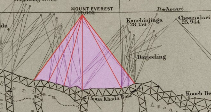
Over the next decade, Waugh’s teams pushed eastward through the jungles of Bengal, Bihar and Orissa, verifying baselines, fixing latitudes and longitudes astronomically, establishing stations that brought the peaks within mathematical reach. Along the entire border, surveyors recorded the peaks.
Close-up of the border survey stations used to observe Peak XV. (Credit: Royal Geographical Society)
To measure Peak XV, six observation stations were selected across the Terai, the deadly malarial lowlands chosen for the clear site lines to the summit. From these stations, surveyors recorded azimuth and elevation angles across multiple seasons. They measured the summit at sunrise, when the peak was first illuminated. None of the surveyors knew the height of the mountains they were observing because distance could not be measured directly. Only when all stations were plotted on a map could the peak’s position be fixed and the elevation calculated. This high-level mathematics fell to the human computers in Calcutta, led by Radhanath Sikdar.
Radhanath Sikdar
By 1851, Sikdar had risen to chief computer, directing the department that transformed field observations into verified measurements. The 1851 Survey Manual acknowledged his distinction: “Babu Radhanath Sickdar, the distinguished head of the Computing Department…whose intimate acquaintance with the rigorous forms and mode of procedure…render his aid particularly valuable.” Yet, neither his education nor his geodetic calculation training prepared him for the complexities of the Himalaya problem. Nonetheless, he took the raw observations and calculated the mountains’ heights to determine which, if any, of the distant peaks was truly the highest point on Earth.
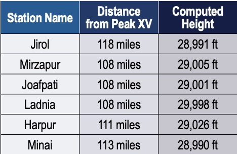
Sikdar calculated the height of each of the peaks. There were many. It was slow, meticulous work. Peak XV required more than standard calculation. Six observation stations produced six independent height measurements, each requiring corrections for atmospheric refraction (light bending through air layers of varying density and temperature), Earth’s curvature (the summit was more than 100 miles away), and plumb-line deviation (the Himalayas’ mass pulled survey instruments slightly toward the mountains).
Sikdar applied the Method of Least Squares, a statistical technique for extracting the most probable value from multiple observations. Each station’s measurement carried uncertainty; combining all six through rigorous mathematics yielded a more reliable result.
The calculation took months. When Sikdar finished, he was stunned: exactly 29,000 ft recalculated and received the same result. The precision seemed too perfect. Sikdar knew the stakes. This wasn’t just another mountain. His calculations were correct. Peak XV was the highest point in the world, Chomolungma, meaning the goddess mother of the Earth. Such a discovery demanded the honor of delivering the news in person.
In April 1852, Sikdar traveled 1,600 km from Calcutta to Dehra Dun. The journey took weeks. He carried the calculations in his satchel and the announcement in his mind.
When Sikdar burst into Waugh’s office with the news, Waugh worried that exactly 29,000 ft (8,830 m) would make surveyors appear to have simply rounded. 2 ft were added, a small fiction to preserve credibility. The official height for Peak XV became 29,002 ft.
Waugh spent four years verifying before the official announcement in March 1856. The mathematics were sound from the moment Sikdar burst into that office. Then, 20 years later, the 1875 Survey Manual erased Sikdar’s name entirely. The British press called it “robbery of the dead.”
Sikdar’s calculations have stood the test of time. The 1954 Survey of India measurement, 102 years later, yielded 29,028 ft, a minimal difference. In 1999, GPS technology placed a receiver on Everest’s summit for the first time: 29,035 ft. The 2015 earthquake prompted the most comprehensive measurement yet.
On May 22, 2019, at 3 a.m., Nepali surveyor Khimlal Gautam departed Everest’s South Col for the 10-hour climb carrying 90 lbs (41kg) of equipment. The pre-dawn timing avoided crowds: the weight included a Trimble R10 GNSS receiver and ground-penetrating radar to distinguish rock height from snow depth. Eight continuously operating reference stations (CORS) were positioned across Nepal to receive signals from GPS, GLONASS, Galileo and BeiDou. Chinese surveyors simultaneously measured from the north.
Gautam spent hours on the summit, collecting data while his body slowly consumed itself in the death zone. He lost a toe to frostbite. A team member nearly died from oxygen depletion. Gautam understood, “Mount Everest symbolizes something in Nepal, but it’s not only a Nepal asset, it’s a world asset.”
The map of the Great Trigonometrical Survey. (Credit: Survey of India, via David Rumsey Collection)
On Dec. 8, 2020, Nepal and China jointly announced their result, agreeing for the first time the height was 29,031.69 ft. Sikdar’s error across 168 years was 31.69 ft, an accuracy of 0.11%.
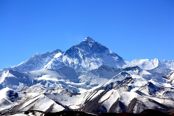
From that moment in Dehra Dun, Sikdar, dusty from the road, calculations in hand, certainty in his voice, we trace backward through 50 years of framework building to understand what made that measurement possible. Peak XV, hidden in plain view, seen for hundreds of miles, refusing to be known, was finally measured.
Once we have measured it, we want to believe we know it, but the Indian and Eurasian tectonic plates continue to collide, pushing the mountain up four millimeters per year. Earthquakes in the region change the topography. The geoid problem persists: What does “sea level” mean 440 miles from the coast in a gravitationally dense region? Modern surveyors still grapple with the fundamental question: What does “height” mean when measured against a theoretical reference surface?
The Great Trigonometric Survey proved that surveyors could measure what they couldn’t touch, calculate what they couldn’t reach, and verify what they couldn’t see. It required building the geodetic infrastructure across a subcontinent, maintaining mathematical precision across decades, and accepting brutal human costs.
Then, the computer was a man. The information was in his satchel. The message was delivered in person. It was the first time the height of the highest known point was determined not by a physical barometer on a summit, but by mathematics alone, a man solving equations in a room 440 miles away. Sikdar proved the impossible: What couldn’t be touched could be measured, what couldn’t be reached could be calculated, and a man dusty from the road could hold the height of the world in the palm of his hand.
Four names for one mountain. Each represents a different understanding. Its ancient name, Chomolungma, and Sagarmatha, its national identity. Peak XV, its cartographic name marking the audacious attempt to measure it, and the name Mount Everest, the crowning achievement, a proclamation honoring mathematics, from Hipparchus who is credited with developing trigonometry to the computers, like Sikdar. It stands as a monument to all the surveying and cartography, especially of the 19th century accomplishing the impossible against extraordinary odds.
Surveying and mapping are jobs of courage and determination exploring the unknown, risking death in malaria-infested jungles, Everest working while stricken with partial paralysis, Abdul Hamid crossing a forbidden border, and Gautam’s predawn climb. They all understood what mattered was worth the risk. It is the surveyor’s call to arms: measure the Earth.
High-precision GNSS applications, such as real-time displacement monitoring and vehicle navigation, rely heavily on resolving carrier-phase ambiguities. However, traditional methods like the R-ratio and W-ratio tests often use empirical thresholds, which can lead to unreliable results due to biases and environmental variability.
These limitations hinder the efficiency of Precise Point Positioning Ambiguity Resolution (PPP-AR), especially in dynamic or challenging conditions. Based on these challenges, there is a pressing need to develop more robust and adaptive techniques for ambiguity validation.
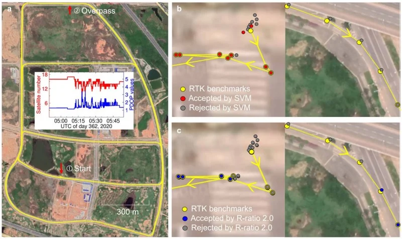
Published (DOI: 10.1186/s43020-025-00167-8) on June 9, 2025, in Satellite Navigation, researchers from the Royal Observatory of Belgium and the State Key Laboratory of Precision Geodesy in China unveiled a Support Vector Machine (SVM)-based method for GNSS ambiguity validation.
The study leverages machine learning to combine multiple diagnostic metrics, achieving higher accuracy and reliability than conventional approaches. The model was trained on extensive datasets and validated through real-world experiments, showcasing its potential to transform high-precision positioning.
The study’s key innovation lies in its integration of seven diagnostic metrics — including R-ratio, ADOP, and ambiguity dimension — into an SVM model. This approach addresses the limitations of traditional methods, which often rely on single thresholds and fail to account for complex dependencies among variables.
The SVM model achieved an 92% success rate in ambiguity validation, outperforming the R-ratio test’s 82% in kinematic scenarios. Notably, the model reduced convergence time prediction errors to just 1.0 minute, compared to 5.0 minutes for conventional methods.
Highlights of the research include:
Enhanced Reliability. The SVM model’s ability to adaptively weigh multiple metrics ensures more consistent ambiguity resolution.
Real-World Validation. A vehicle-borne experiment demonstrated a 92% success rate, proving the method’s practicality in dynamic environments.
Scalability. The framework is adaptable to both single- and multi-constellation GNSS systems, broadening its applicability.
Despite its advancements, the study acknowledges a 5% error rate in unresolved ambiguities, pointing to future research directions, such as incorporating variance-covariance data for further refinement.
“Our SVM model represents a paradigm shift in ambiguity validation,” emphasized Jianghui Geng, co-author of the study. “By harnessing machine learning, we’ve not only improved accuracy but also provided a scalable solution for diverse GNSS applications, from autonomous vehicles to geodetic monitoring.”
The SVM-based method holds significant promise for industries requiring ultra-precise positioning, such as autonomous navigation, aerospace, and infrastructure monitoring. Its ability to shorten convergence times and enhance reliability could revolutionize real-time GNSS applications, particularly in urban or obstructed environments where signal interruptions are common.
Future iterations of the model, incorporating additional data layers, could further bridge the gap between theoretical precision and real-world performance, setting a new standard for GNSS technology.
The Wall Street Journal has reported mysterious UAVs spotted surveilling some of America’s most sensitive military sites, leaving the Pentagon struggling to respond. These unidentified UAVs have been seen flying over military installations in Virginia and Nevada throughout the past year, including the secret base of the Navy’s elite SEAL Team Six and Naval Station Norfolk, recognized as the world’s largest naval port.
Former U.S. Air Force Gen. Mark Kelly told The Wall Street Journal he first became aware of mysterious UAV sightings in December 2023, when officials at Langley Air Force Base in Virginia reported seeing dozens of UAVs flying over the base at night.
The source of these UAVs remains unknown, leaving officials puzzled about whether they were operated by sophisticated hobbyists or potentially by Russia or China. The complexity and coordination of the flights suggested a level of sophistication beyond civilian drone operations, according to the report.
The U.S. military faced significant challenges in addressing this threat. Federal law restricts the military’s ability to shoot down UAVs over bases unless they pose an immediate threat. Aerial snooping does not qualify as a threat, though some lawmakers hope to give the military greater leeway to address these challenges in the future.
The sightings ended on Dec.23, 2023, with authorities still unsure of the UAVs’ origin or who controlled them. However, a clue emerged in January 2024 when a Chinese student named Fengyun Shi, studying at the University of Minnesota, was caught flying a UAV near Langley Air Force Base. Shi’s UAV got stuck in a tree, which he abandoned before flying to California. The FBI retrieved the drone, discovering it had taken photos of Navy ships docked at the base, which led to Shi being sentenced to six months in federal prison.
In October 2024, U.S. officials confirmed that similar drone swarms had been observed near Edwards Air Force Base in Nevada. The Department of Defense (DOD) has not publicly identified the source behind these surveillance drones.
In response to these incidents and potential threats, Langley Air Force Base is exploring new measures to safeguard its airspace. The base’s 633rd Contracting Squadron issued a notice seeking proposals for installing anti-drone nets around sunshades used for aircraft, including F-22s. These nets are designed to disable small UAVs while allowing quick retraction to ensure flight operations remain unaffected. The proposed system would withstand extreme weather conditions and prevent drones from interfering with aircraft or personnel.
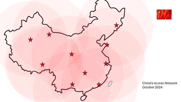
The Dunhuang long-wave timing station, a critical component of China’s high-precision ground-based timing system, has been completed and tested. This marks a significant advancement in China’s development of a three-dimensional cross-timing system that spans air, space and land.
Zhang Shougang, director of the National Time Service Center of the Chinese Academy of Sciences, told Xinhua News that the high-precision ground-based timing system leverages eLoran radio long-wave and fiber-optic timing technology. This system is designed to operate independently of satellite navigation timing, providing backup, complementary functions and mutual enhancement with existing timing systems.
China has constructed three additional long-wave timing stations in Dunhuang, Korla and Nagqu. When combined with existing stations, the new stations are designed to achieve nationwide coverage of long-wave timing signals.
During the construction of the Dunhuang station, researchers reported significant breakthroughs in high-precision transmission control and pulse time reference feedback modulation technology. They achieved a megawatt-level Loran timing transmission accuracy of 20 ns, surpassing the current international standard of 50 ns.
This advanced timing system seeks to support economic and social operations, foster technological development and improve national security. Zhang Shougang noted that after nearly 60 years of development, China has built the world’s most technically complete national timing system.
China’s BeiDou high-precision navigation and positioning service platform has entered trial operation, The National Geomatics Center of China reported.
Developed under the leadership of the Ministry of Natural Resources, the platform integrates satellite navigation and positioning base stations nationwide within the natural resources system. This initiative consolidates more than 3,300 base stations into a unified network, offering centralized management of station resources.
The network offers seamless, high-precision positioning services nationwide, delivering real-time, accurate and reliable navigation for sectors including public welfare mapping, resource surveying, intelligent transportation, autonomous driving, precision agriculture and social governance.
The service is available both online and offline. Online, it offers real-time observation data and enhanced positioning services. Offline, the platform delivers coordinate results, post-event observation data files, and related products.
The BeiDou Navigation Satellite System (BDS) was initiated in 1994. The construction of BDS-1 and BDS-2 was completed in 2000 and 2012. When BDS-3 was completed and put into service on July 31, 2020, China became the third country to have an independent global navigation satellite system.
The Federal Communications Commission (FCC) is investigating whether the use of Russian and Chinese foreign satellite systems by U.S. mobile phones and other devices poses security threats.
The FCC has concerns that U.S. handheld devices are receiving and processing GNSS signals from satellites controlled by foreign adversaries in violation of commission rules.
The FCC is seeking answers from handset manufacturers Apple, Google, Motorola, Nokia, Samsung and others that collectively cover more than 90% of the U.S. smartphone marketplace.
“There is no established record of what security threats, if any, these signals carry and whether the manufacturers of handheld devices are processing these signals in violation of the Commission’s rules,” an FCC spokesperson said in a statement.
Representative Mike Gallagher, chair of the U.S. House Select Committee on the Strategic Competition Between the United States and the Chinese Communist Party, wrote FCC Chair Jessica Rosenworcel earlier this week raising concern about reports that U.S. cell phones were receiving and processing signals from Chinese and Russian satellites.
The FCC has only approved U.S. phones to receive and process signals from the U.S. Global Positioning System (GPS) and the European Galileo GNSS.
Due to China’s rapid growth, the G85 highway, which opened in 1995 and connects Chongqing to neighboring provinces, in 2023 required expansion to four lanes. Like with any construction project, the first step was a survey. When the highway was built, surveyors had to rely on total stations and other optical instruments. Today, despite the availability of GNSS receivers, surveying over long distances in rugged terrain is still challenging.
Orthophoto of the service area in the section of the G85 highway that is being enlarged. (Photo: CHCNAV)
Li, a surveyor responsible for surveying a 5 km section that included a service area, bridges, culverts, and embankments, wanted to avoid closing lanes, which would have been expensive and dangerous due to heavy traffic. Additionally, using only GNSS receivers and total stations to complete the project would take a long time and potentially require multiple surveys. Instead, he opted to conduct a lidar survey.
To meet the project’s 2 cm root mean squared error (RMSE) accuracy requirement, Li established ground control points (GCPs) before scanning. To avoid disturbing the traffic and ensure safety, he placed the GCP targets within 50 m of the roadside. Then, a 50-minute flight was enough to scan the 5 km section.
The data was then imported into CHCNAV’s CoPre lidar processing software, which performed point cloud correction and bundle adjustment, increasing the absolute accuracy of the road surface point cloud to the required 2 cm. Next, the software performed point cloud classification, modeling, point cloud coloring, and image georeferencing and generated depth maps.
The resulting color point cloud clearly shows road markings and other features, and makes it possible to accurately measure the locations of drainage ditches, slopes, and culverts. For power lines crossing the highway, the point cloud provides accurate measurements of the minimum distance between the lines and the road for safe equipment operation.
Lidar scanning captures detailed ground surfaces, but road design relies on actual terrain conditions. Using CHCNAV’s CoProcess post-processing software — which has built-in adaptive ground point filtering algorithms — the team removed vegetation, guardrails, and vehicle returns, revealing the bare ground for design. They also accurately extracted road features, including dashed and solid lane lines with width and line type parameters, to enhance the efficiency of subsequent design efforts.
Lidar point clouds provide much richer ground detail than traditional surveys. This allows CoProcess software to automatically generate cross-sections from processed point clouds, while manual editing options are available for special terrain, such as roadside ditches. Sections can be exported to design formats or CAD drawings for immediate use.
For this project, two engineers performed the field scanning, and one engineer handled the point cloud processing, classification, and modeling to provide multi-dimensional data that met the 2 cm accuracy criteria.
Geely, a Chinese automaker, has launched its second set of low-Earth orbit (LEO) satellites in its effort to enhance navigation capabilities for autonomous vehicles. The 11 satellites were launched from the Xichang Satellite Launch Center in Sichuan, China province.
According to Geely, the company aims to have 72 satellites in orbit by 2025. The long-term goal is to establish a constellation of 240 satellites to create a comprehensive satellite network for various applications.
Geely’s satellite network is designed to provide high-precision positioning support for autonomous vehicles. By using satellite technology, the company aims to enhance navigation accuracy to enhance safety and efficiency on the roads.
The newly launched satellites are equipped with artificial intelligence (AI) remote sensing capabilities, which allows them to capture clear high-resolution imaging. With a resolution ranging from 3.2 ft to 16.4 ft, these satellites can provide valuable data and imagery for multiple applications, including surveillance, urban planning and infrastructure management.
China’s satellite industry has seen a significant surge in commercial activities since the government allowed private investment in the space sector. With supportive policies and investments, numerous commercial companies, including Geely, have ventured into satellite manufacturing and launch vehicles.
“Seen & Heard” is a monthly feature of GPS World magazine, traveling the world to capture interesting and unusual news stories involving the GNSS/PNT industry.
According to the 2023 Arctic Report Card by the National Oceanic and Atmospheric Administration (NOAA), new records have been documented showing that human-induced warming of the atmosphere, ocean and land is creating adverse impacts on people, ecosystems and communities across the Arctic region. The report states the Arctic is experiencing a faster rate of warming than any other part of the world. Overall, it was the Arctic’s sixth-warmest year on record. Sea ice extent continued to decline, with the past 17 Septembers now registering as the lowest on record.
Researchers from Chang’an University in China have developed a new method of tracking landslides. The team combined GNSS precise point positioning (PPP) techniques with a cumulative sum control chart (CUSUM) method. Conducted at the Tengqing landslide in Liupanshui, Guizhou Province, Southwest China, the study aims to enhance the precision in tracking the movements of the landslides and improve the overall reliability of the monitoring results.
Crabs on the move
Image: United States Geological Survey (USGS)
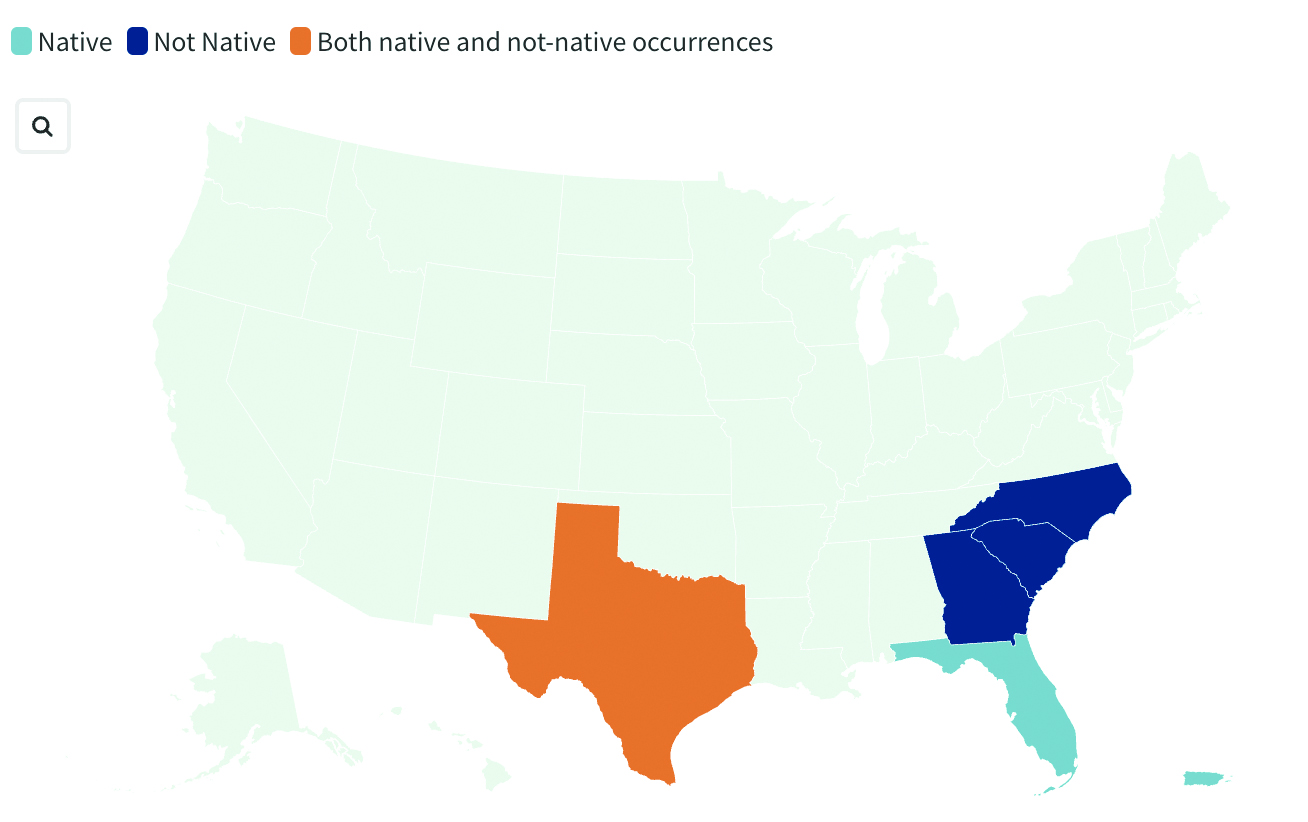
Georgia officials are asking the public for help in spotting non-native blue land crabs as they appear to be moving north in recent years, according to data collected by the United States Geological Survey (USGS). According to USGS, it is unclear whether this movement is driven by humans or by the crabs themselves, or if the crabs are breeding in their non-native homes. Officials worry about the damage caused by the crabs’ burrowing behavior. While scientists learn about how the species interacts with its new environment, several states are asking residents to report sightings.
India’s war on drugs
Image: evandrorigon / E+ / Getty Images
India’s border security force (BSF) has said it is battling an unprecedented UAV “menace” infiltrating the border with Pakistan, fueling the drug crisis in the state of Punjab and raising serious security issues, reported The Guardian. UAVs have dropped weapons such as pistols and Chinese-made assault rifles, as well as consignments of opium and heroin believed to be from Afghanistan.
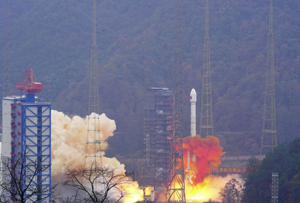
China has launched two satellites into medium-Earth orbits (MEO) for its BeiDou Navigation Satellite System, reported the China Satellite Navigation Office.
The satellites were carried by a Long March 3B rocket from the Xichang Satellite Launch Center in Sichuan province and are the 13th group of third-generation BeiDou satellites operating in MEO.
The two spacecraft will start formal operation after a period of in-orbit technical verification, according to the China Satellite Navigation Office.
BeiDou is China’s largest civilian satellite system and one of four global navigation networks, along with the United States GPS, Russia’s GLONASS and the European Union’s Galileo.
Since 2000, a total of 62 BeiDou satellites, including the first four experimental ones, have been lifted on 46 Long March 3 series rockets from Xichang.
In June 2020, the final satellite to complete Beidou’s third-generation network was lifted by a Long March 3B rocket launched from the Xichang center. The following month, the system was declared complete and began providing full-scale global services.
Nearly 50 Beidou satellites in active service, including the latest pair.
“Seen & Heard” is a monthly feature of GPS World magazine, traveling the world to capture interesting and unusual news stories involving the GNSS/PNT industry.
By using location data and a username from a Lime rental scooter, police have identified a man caught on video scootering around a Denver, Colorado, neighborhood loading up on stolen goods from surrounding homes, reported 9 News. Police obtained a search warrant for the scooter’s location data and account information. The suspect appears to have used his real name when renting the scooter to conduct the burglaries. 9 News is not naming the man identified as the scooter user as he hasn’t been arrested or charged. However, a background check on his name revealed he’s currently wanted on two theft cases that occurred in 2022, also in Denver.
Doordashing goes wrong
Image: ProjectB/E+/Getty Images
A DoorDash driver followed his navigation system into a wooded area and then into a body of water while attempting to deliver an order to a residential neighborhood in Middleton, Massachusetts, reported the Daily Caller. After following the navigation system straight into water, the driver called police. The Middleton Police Department is now charging the DoorDash driver for “negligent operation of a motor vehicle” and has put in a request to suspend the driver’s license.
Researchers at the Jiangxi Nanfengmian National Nature Reserve in China are utilizing BeiDou during bird banding to monitor their migration period from September to October. Bird banding involves attaching customized tags to birds’ legs or wings to track their movements and patterns. Out of 614 birds, 36 are being equipped with specially designed positioning devices that will continuously transmit data for researchers to analyze migration routes, stopping places, and migration time, according to a nature reserve official.
More than 20 airline and corporate jets flying over Iran overnight on October 1, were targeted by spoofed GPS signals. The spoofed signals were sent from the ground, infiltrated the navigation systems of the jets, and steered them off course, reported The Times of India. According to the Ops Group, which runs a flight data intelligence crowdsourcing website, a majority of the GPS spoofing occurred in airway UM688 in Iran’s airspace. In response, the U.S. Federal Aviation Administration issued this warning to airlines: “Iraq/Azerbaijan — GPS jamming and spoofing poses safety risk.”