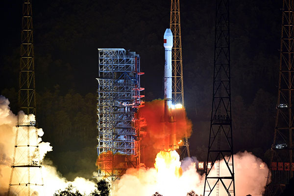
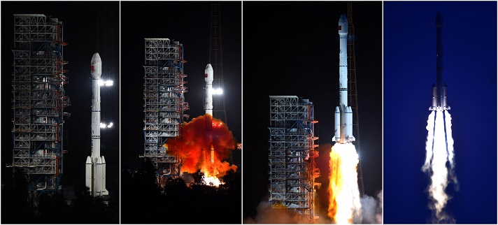
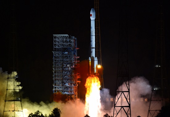
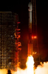
The Chinese Beidou system’s 23rd satellite was launched into orbit Sunday aboard a Long March 3C rocket.
The Long March 3C rocket lifted off at 1530 GMT (11:30 a.m. EDT) from the Xichang launch base in southwestern China’s Sichuan province, according to the state-run Xinhua news agency.
The satellite was deployed into an elliptical orbit more than 22,000 miles (35,700 kilometers) above Earth. It will power its way into a circular geosynchronous orbit over the equator in the coming weeks.
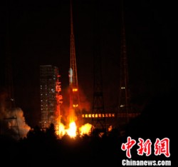
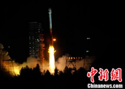
China launched the 22nd BeiDou satellite into orbit on Tuesday. BeiDou-22 (or BeiDou-2 I6) was launched at 20:11 UTC (4:11 local time) by a Long March-3A rocket from the Xichang Satellite Launch Center.
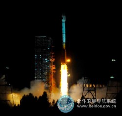
China launched the 21st BeiDou satellite on Feb. 1, the second in a series of BeiDou launches schedule for 2016. The BeiDou constellation is planned to be completed in 2020.
The new satellite, the sixth BeiDou-2 IGSO, will be used to replenish the current operating regional system.
The satellite, after entering its designed work orbit and finishing in-orbit testing, will join others already in orbit and improve the stability of the system, preparing for BDS to offer global coverage.
A Long March-3A carrier rocket carrying the 22nd BeiDou satellite lifted off March 30.The 22nd BeiDou satellite is one in a series of launches planned this year.
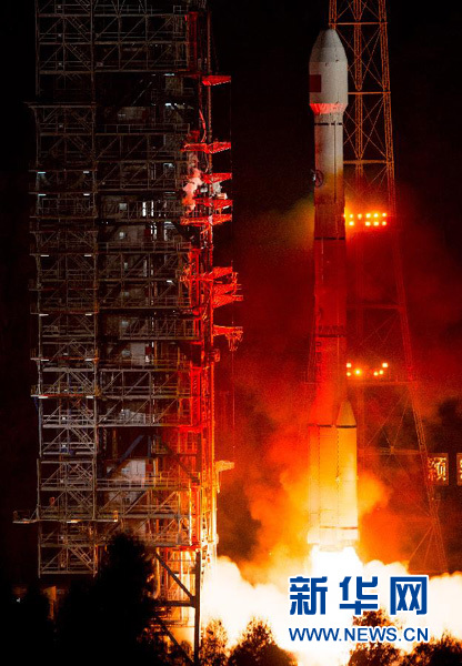
A Long March-3C carrier rocket carrying the 21st satellite for the BeiDou Navigation Satellite System lifts off from Xichang Satellite Launch Center,southwest China’s Sichuan Province, Feb. 1, 2016.
China has launched its 21st BeiDou satellite into orbit, according to Xinhua News Agency, the official press agency of the People’s Republic of China.
The launch took place at 3:29 p.m. Beijing Time (07:29 UTC) on Monday, Feb. 1.
Launched from Xichang Satellite Launch Center in the southwestern province of Sichuan, the satellite was boosted by a Long March-3C carrier rocket into medium Earth orbit (MEO).
A video of the launch appears here. Also, below is amateur video of the launch.
A huge network of iBeacon (Apple)and Eddystone (Google) devices has emerged in China, consisting of 110,000 units run and managed by Sensoro.
The network spans 25 movie theatres, 16 airports, 39 high-end retail stores, 40 major tourist destinations, 200 universities, 260 high-speed trains, 1,500 Pizza Huts and 2,100 Chow Tai Fook (CTF) jewelry stores, among other locations.
Sensoro was founded in July 2013 through the Microsoft Ventures Accelerator program for startups. Its goal is to construct a data network that integrates intelligent sensors (in this case, Bluetooth) and the mobile Internet.
During the 2015 Chinese New Year in February, traffic at beacon-outfitted locations reached the hundreds of millions, according to a Sensoro blog. CTF’s use of the iBeacons generated 11 million dollars in revenue with a coupon conversion rate as high as 63 percent, far surpassing expectations, according to CTF’s 2015 earnings report. CTF has since deployed beacons in all 2,100 of its mainland China retail stores.
Data gathered by Sensoro will allow retailers to target customers with increasing accuracy the longer the network is in use.
The three BeiDou satellites launched this year are sending twice as many signals as their predecessors, reports the Economic Times, following tests of the orbits and key technology.
The 18th and 19th satellites are the first BeiDou satellites that can communicate with each other, helping with distance measurements, said Wang Ping, chief engineer on the project.
After the tests, they are working as intended and in all weather, according to a newsletter from the China Academy of Space Technology.
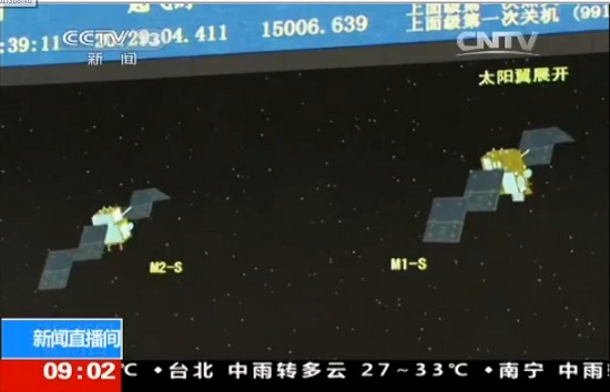
China launched two BeiDou navigation satellites into medium Earth orbit on July 25.
China launched two BeiDou navigation satellites into medium Earth orbit on July 25.
The two new satellites, BeiDou-3 M1 and BeiDou-3 M2, are in orbital slots 1 and 6 of Plane 1 (or A Plane), respectively. The satellites are designated BDS M1-S and M2-S — the “S” may stand for “Test” (in Chinese: 试验 = Shiyan).
On Aug. 14, China stated one satellite was working autonomously and had set up a link with the other satellite, successfully testing the autonomous control technology of the Beidou constellation. The inter-satellite link realizes communication and distance measurement among satellites, bringing autonomous control of the system a step closer.
Autonomous navigation is the project’s key to global operation. It enables satellites to work independently, providing users with more accurate data, according to BeiDou design engineers.
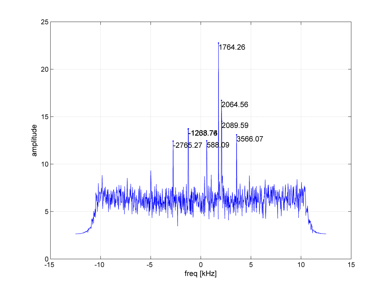
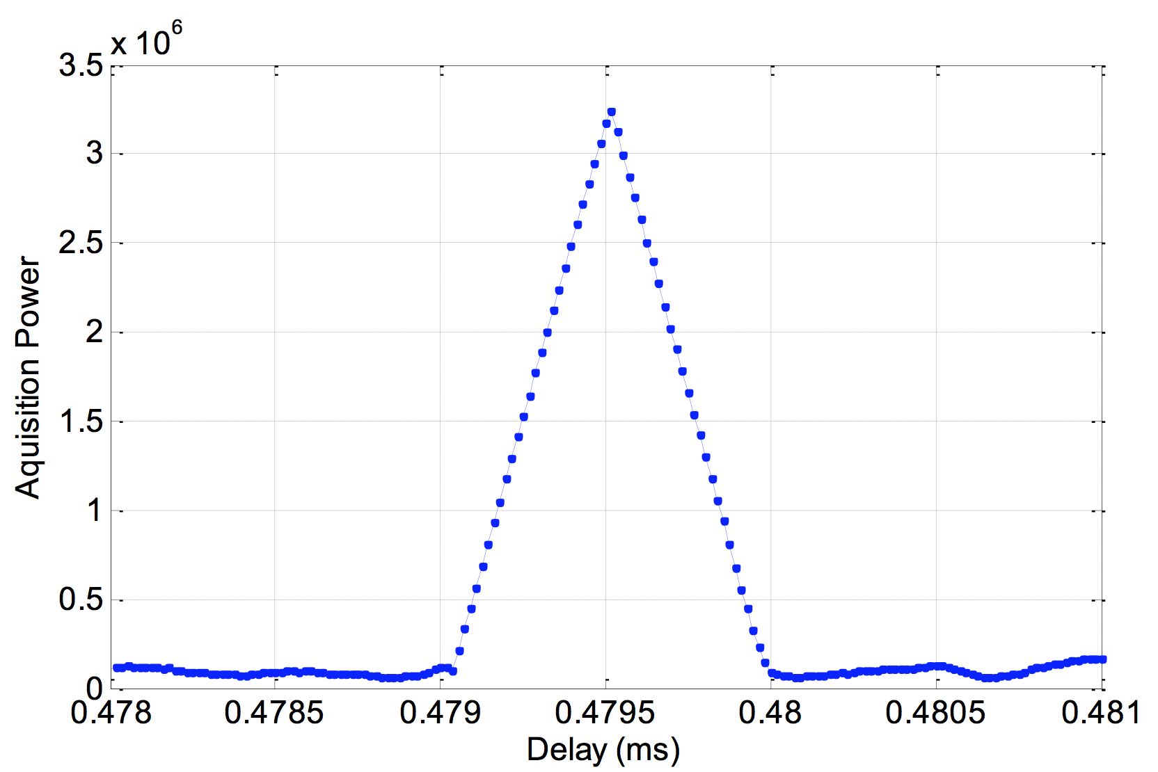
On Aug. 9, signals from the two new BeidDou satellites were received with a software-defined radio sampler operated at the European Commission’s Joint Research Centre in Ispra, Italy. The sampler is driven by orbit-prediction software that triggers a synchronized acquisition on both 1575.42 MHz and 1278.75 MHz using 1-bit complex samples at 60 megasamples per second (about 60 MHz total bandwidth). The two-line element sets for the orbits were obtained from the CelesTrak website, and predicted positions were computed using code developed following the Simplified General Perturbations Satellite Orbit Model 4 (SGP4) as documented in the U.S. Department of Defense Spacetrack Report No. 3.
To confirm the identity of the satellite being tracked using codeless tracking, we matched the measured Doppler frequency shift with the predicted one. The local oscillator clock drift was modeled using GPS L1 C/A-code signals and taken into account when matching the Doppler shift.
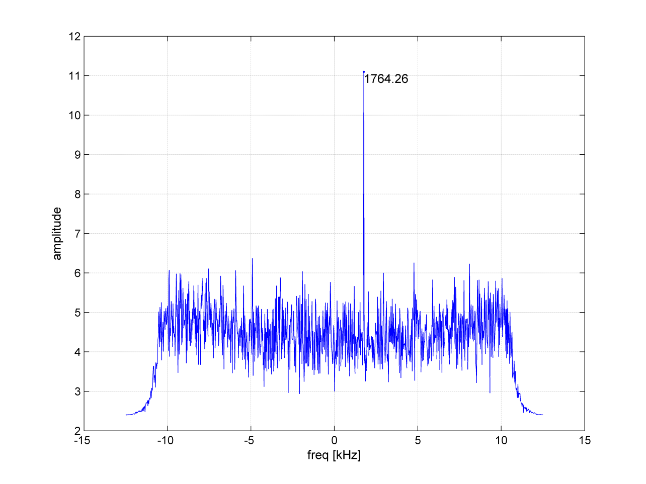
According to a presentation given at Stanford University’s 2014 PNT Symposium by Mingquan Lu and Zheng Yao from Tsinghua University, modernized BeiDou satellites broadcast an MBOC(6,1,1/11) [a multiplexing of BOC(6,1) and BOC(1,1) signals] and a BOC(14,2) signal on the L1 frequency. Neglecting the BOC(6,1) term, side lobes were brought to baseband and cross-correlated by our equipment. In Figure 1, the peak at 1756.41 MHz is BEIDOU-3 M2. This is also confirmed by cross-correlating the lobes of the BOC(14,2) signal, which is quite a unique feature of the new satellites (see Figure 2).
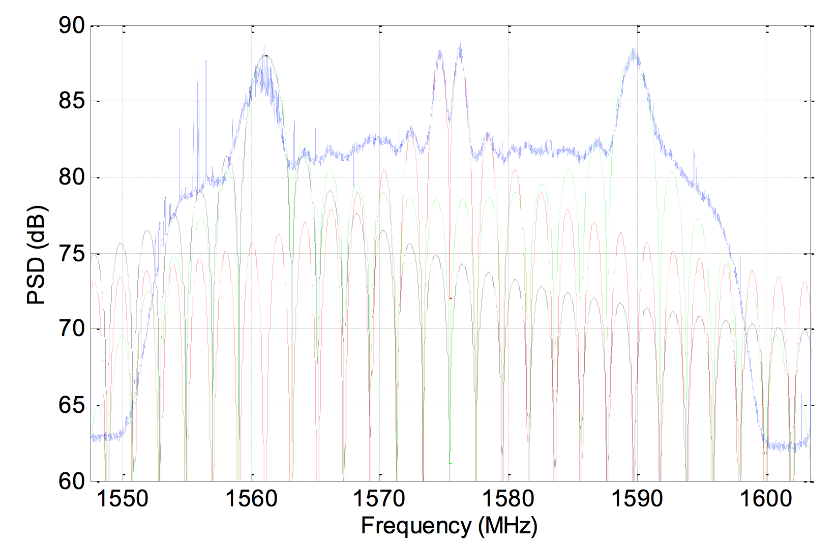
On Aug. 10, a 1.8-meter dish was pointed at the satellite, and a Tektronix RSA306 USB Real Time Spectrum Analyzer was used to sample the signal on L1 with 14-bit resolution at 112 megasamples per second. The resulting power spectrum is shown in Figure 3.
Figure 3. Power spectral density of BEIDOU-3 M2 on L1.
The spectrum shows very good overlap between the anticipated BOC(1,1) signal in red, BOC(14,2) in green and BPSK(2) in black. In fact, PRN33 correlates with the low side lobe suggesting that the satellite is also broadcasting a legacy signal on 1561.098 MHz (see Figure 4).
Figure 4. Cross-correlation of a BPSK(2) BeiDou code PRN33 on a 1561.098-MHz carrier.
Meanwhile, tracking by stations participating in the International GNSS Service Multi-GNSS Experiment has established that the second recently launched BeiDou Phase 3 MEO satellite is using PRN code 34, and that the first Phase 3 satellite, BeiDou I1-S launched on March 30, 2015, into an inclined geosynchronous orbit, is using PRN code 31.
Two BeiDou navigation satellites were launched into medium Earth orbit on Saturday, July 25, at 12:29:04.411 UTC, according to a NASASpaceFlight.com Forum blog. The satellites are drifting to their designated orbits. U.S. Joint Space Operations Center / NORAD is tracking the satellites.
The satellites are designated BDS M1-S and M2-S — the “S” in the satellite names might stand for “Test” (in Chinese: 试验 = Shiyan).
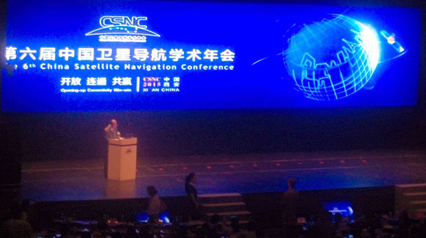
Report from the 2015 China Satellite Navigation Conference
By Greg Turetzky
This May, the sixth China Satellite Navigation Conference (CSNC) was held in Xian, site of China’s famous buried warrior tombs. This was the fourth time I have attended, and every year the event has grown in both attendance numbers and global importance.
The conference opened with the usual provider updates on satellite systems and international collaboration. There was nothing truly unexpected. All the providers continue to make progress towards launching new satellites with new capabilities, as well as providing regional augmentation systems for aircraft navigation.
The hosts were their usual gracious selves and put on a very entertaining evening at “The Night of Beidou” event with wonderful food as well as music, dancing and and acrobats.
Exhibit Hall
The show floor continues to grow at a rapid rate. The program listed122 exhibitors. The market has clearly entered the rapid proliferation stage. The booths were large, well-staffed and busy even during times when technical sessions were in progress. It was hard for me to determine what kind of business was being conducted as there were not many booth staff that spoke English. However, that seemed very appropriate as it was clear that the Chinese domestic market for BeiDou, or BDS, is well established and growing.
In fact, many of the booths were regionally sponsored as there seems to be plenty of local subsidization to grow the GNSS industry in all areas of China. Many companies were displaying end-user products for all segments, from watches to phones to automotive to survey. I also noted significant growth in the number of chipset suppliers; I stopped counting at 10. Of further note and interest, the first few mergers/partnerships have taken place, as the market starts to make its natural turn from proliferation to consolidation.
Technical Sessions
The technical content of the conference is impressive. Approximately 280 papers were presented in up to nine simultaneous tracks over three days. Another 100+ posters were available for viewing.
Here are titles of a few of the papers I liked:
Analysis of relative positioning performance of BDS triple frequency
Anti-spoofing design for Civil Navigation Signal system
Clock-error resolution strategy and precision analysis of GNSS real-time precise satellites
Research on detection and identification methods of satellite navigation RAIM multi-satellite failures.
Research on Wi-Fi/INS indoor pedestrian navigation system based on environmental feature augmentation
Reflections on demands of BDS intellectual property rights in satellite navigation industries
Review of anti-interference RF of satellite navigation receivers
A new TOA estimation method for the navigation pulse of X-ray Pulsare.
If you plan to visit next year, you should consider bringing a translator. Many of the sessions have simultaneous translation, and most of the presentations have both English and Chinese slides, but not all of them. In the past, I have always enjoyed the policy and IP session, but this year it did not have a translator and the presenters spoke in Chinese, so I cannot give you much information. I did notice that several other U.S. companies had sent representatives who were native Chinese speakers.
Conclusion
The Chinese market is now full of grown tigers. I think they worry more about domestic competition for large domestic opportunities than they do about foreigners taking market share from them. That kind of competition has spurred them to catch up quickly in terms of technology and performance to where the big foreign competitors are. I foresee intense domestic competition in the short term leading to fewer, bigger, stronger players who will then be well positioned to compete in the global marketplace.
GREG TURETZKY is a principal engineer at Intel responsible for strategic business development in Intel’s Wireless Communication Group focusing on location. He has more than 25 years of experience in the GNSS industry at JHU-APL, Stanford Telecom, Trimble, SiRF and CSR. He is a member of GPS World’s Editorial Advisory Board. See his previous reporting on the 2014 CSNC, “Tigers, Tycoons on View at China Satnav,” and the 2013 conference, “Little Tigers versus Wolves.”
The statements, views, and opinions presented in this article are those of the author and are not endorsed by, nor do they necessarily reflect, the opinions of the authors present and/or former employers or any other organization the author may be associated with.
Singapore and China are jointly opening a center to develop applications for the BeiDou GNSS, according to a report in Space News. The nations also have signed a commercial agreement to create anti-jamming systems to protect BeiDou signals.
At a briefing during the CommunicAsia show held in Singapore May 31-June 2, SpaceTime Technology Pte Ltd. and ST Electronics (Satcom & Sensor Systems) Pte Ltd. signed a memorandum of understanding to “develop in Singapore an interference-resistant Beidou satellite positioning system,” SpaceNews report.
The companies said the goal is to protect BeiDou signals from unintentional jamming in urban environments, where wireless devices occasionally overstep their radio-frequency boundaries.
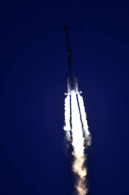
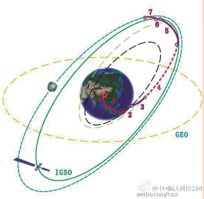
UPDATE (3/31/15): The BeiDou satellite is being targeted for an IGSO orbit, not a MEO orbit as previously speculated. The two images below make this clear.
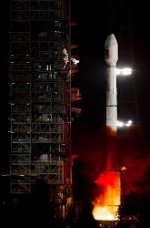
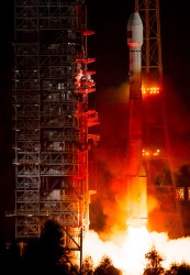
Photo: BeiDouPhoto: BeiDou
Below is a CCTV (China Central Television) news story covering the launch.
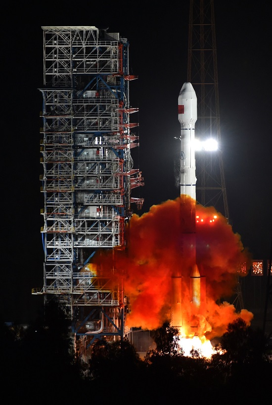
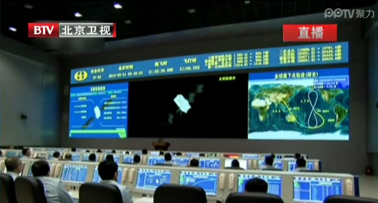
UPDATE (3/30/15): China’s launch of BeiDou-3 M1 is now being reported in that country’s media. The launch occurred at 21:52 on March 30. BeiDou-3 M1 is the first of 17 next-generation Beidou navigation satellites. It will have a new navigation signal system with inter-satellite links and other tests to verify the satellite navigation system.
NASA Spaceflight is reporting that China is believed to have launched the first of a new generation of navigation satellites for its BeiDou constellation. However, the launch has received a blackout in China, with lift-off only confirmed by local observers.
The possible launch of BeiDou-3 M1 took place at 13:52 UTC today from the Xichang Satellite Launch Center on a Chinese Long March 3C rocket, with the debut use of the new Expedition-1 (Yuanzheng-1) upper stage.
Today’s launch involved a new series of satellites that is expected to mark an advancement in the completion of its Beidou Phase III program several years ahead of schedule, by as soon as 2017 rather than 2020, NASA Spaceflight reports.
The Beidou Phase III system includes the migration of its civil Beidou 1 or B1 signal from 1561.098 MHz to a frequency centered at 1575.42 MHz – the same as the GPS L1 and Galileo E1 civil signals — and its transformation from a quadrature phase shift keying (QPSK) modulation to a multiplexed binary offset carrier (MBOC) modulation similar to the future GPS L1C and Galileo’s E1. The current (Phase II) B1 open service signal uses QPSK modulation with 4.092 megahertz bandwidth centered at 1561.098 MHz.
Geography Paints Both Rosy and Grim Picture of the World
In the late ’80s, as a graduate student at UNC Charlotte, I was learning about “New Geography” using a cutting-edge technology called GIS (Geographic Information Systems). One of our professors coined a perfect definition of what made this New Geography different from traditional cataloging of locations and attributes. Quoting Dr. Gerald Ingalls, “Old geography dealt with the simple question: What is where? New geography, using analytical tools such as GIS, is now able to answer: Why what is where.” So knowing the quantifiable “why” hopefully gives us insight into ways to shape and mitigate geography-related problems.
It’s easy to focus on the technology aspects of GIS and forget the reason for our tradecraft. I was reminded of that reason when I recently read a book that took me back to our geospatial roots and demonstrates New Geography exceptionally well. The book, The Accidental Superpower by Peter Zeihan, effectively uses geography and analytics to explain how the world has been shaped and is evolving. In his book, Mr. Zeihan links many current geopolitical events to geography, demographics and the 1944 Bretton Woods settlement which to me is one of the clearest examples of American exceptionalism.
Bretton Woods
For those of you not familiar with Bretton Woods, it was pretty much the United States telling the rest of the world how things will be after the pending end of WWII. The U.S. had turned the tide of war, built up its own industrial power while not suffering home-front damage, and had fashioned the world’s strongest Navy. You can imagine the shock of world leaders when they learned that the U.S. was not looking for reparations or even new land other than enough to bury their dead. Instead, the U.S. was going to open its markets to the world, use its Navy to protect free trade, and even help rebuild devastated countries with programs like the Marshall Plan. All has been pretty good for the past 70 years as Bretton Woods created a global holiday from instability. However, according to Mr. Zeihan, the forces of geography, demographics and new technology will unravel Bretton Woods and slowly change the world.
The Bretton Woods Conference, 1944.
Geographic Factors in the Analysis
We all learned in high school geography that severe climates such as frigid or oppressive tropical climates stifle civilizations, while more temperate climates help civilizations advance. Those are very broad generalizations, but the world is more complex than that, and Peter Zeihan has woven detailed geography into a complex picture of the world. He cites many factors that uniquely and collectively benefit the United States but are shortcomings to a greater or lesser extent in other countries. Key factors included farmable land, rivers and coastal ports for economic trade, oil, industrial capacity, education, demographics and others. In the lottery of world geography, the U.S. has been blessed. I would add that the character of its citizens also plays a key role.
Although there are critics of some of Zeihan’s conclusions and predictions, there is no doubt that his book is an exceptionally detailed compendium of countries and the geopolitical pressures that affect them. He focuses strongly on the presence of rivers, since they provide very cheap transportation of commodities thus reducing the need for many transportation infrastructure projects. The book gets into great detail about countries that most of us can’t even point to on a world map such as Kazakhstan, Turkistan, Uzbekistan and other stans. He explains why many factors bode well for Uzbekistan, but not so much for Russia and China. He shows why Russia considers keeping Ukraine in its camp absolutely vital to its own survival.
One surprise was the case he built that Alberta, Canada, may be motivated to leave its non-supportive national government to join a more like-minded and geographically connected United States. This would completely open the U.S. market for Alberta grain and oil while providing seamless transportation throughout the U.S. Additionally, as a state, the Keystone pipeline would not fall under State Department or executive review.
Demographics
Mr. Zeihan addresses the importance of demographics using a well-known example, Japan. Low birth rates and limited immigration have placed Japan into the difficult position of supporting an increasingly older population with fewer and fewer young citizens. This inverted population pyramid is a pure numbers issue that cannot be solved quickly. He shows how many European countries are trending in the same direction on a slightly later schedule. Russia is suffering from both lower birth rates and decreased education of its population. By contrast, better birth rates and better educated immigrants are preventing an inverted pyramid here in the U.S.
Technology
Mr. Zeihan highlights technology as playing an important role in raising or lowering the importance of some geographic factors. Two in particular have snuck up on the radar: fracking and 3D printing. Who would have thought that the U.S. would be on a path to becoming the world’s largest energy producer thanks to fracking? This will obviously diminish our need for Mideast oil and have a very serious effect on small unfriendly oil producers such as Venezuela, who is already seeing a drop in sales of its relatively hard-to-refine black oil. (Note the political unrest there this week as oil revenues decline.)
I wrote about the potential impact on industry of 3D printing last year, and Peter Zeihan seems to share that opinion. As manufacturing moves closer to the consumer, jobs in China will decline, as will the need of transoceanic shipment of finished goods. The result: the U.S. will see a rebirth of local manufacturing.
Rings containing superconducting magnets will confine the plasma inside the reaction chamber. (Credit: Eric Schulzinger/Lockheed Martin)
If fracking and 3D printing are going to be significant factors, imagine what will happen to the world order if the recent announcement by Lockheed Martin that its researchers have cracked compact fusion comes to fruition. This was announced too late for inclusion in Mr. Zeihan’s book, but my guess is that he would consider it to be the quintessential game changer. It would affect many geographic factors — lower the cost of all transportation, expand industry, desalinate water cheaply, make marginal land farmable, negate the limitations of oil/gas access and do all of this while reducing pollution, increasing safety and eliminating the ability to militarize this form of nuclear power.
Conclusion
I was only able to touch on a few key points in Peter Zeihan’s book. The total picture is very complex. It was clearly well researched and logically thought through. I have only two criticisms. First, Mr. Zeihan stated that he has “always loved maps,” but this book has mediocre black-and-white maps that are less than ideal to display complex geography. It screams for decent color maps, if not in print at least as supplemental website PDFs.
Second, the book delves into significant predictions that I believe should be read with a very critical eye. There are many wild cards and personalities that can steer geopolitics. As a former analyst for the geopolitical security firm Stratfor, Mr. Zeihan worked for George Friedman, the co-author of the 1991 book The Coming War with Japan. I’m glad that didn’t come true.
I know that for many of you working in the intel community this will be very basic information and analysis that is your daily bread and butter. For the rest of us, it’s a good overview and I recommend getting this book. It will be a handy reference, if for no other reason than to sound knowledgeable at water cooler debates. However, I believe that its value is more serious than that and will prove repeatedly useful as an overarching insight as history unfolds.
The increased use of Geographic Information Systems (GIS) in disaster management has resulted in the growth of the GIS market in China, which is expected to post a CAGR of 11.75 percent from 2014-2019, according to research from TechNavio.
The report “GIS Market in China 2015-2019” focuses on the increased use of GIS technology across various systems such as forest fire management, flood management and climate change, which has made GIS technology an effective tool for disaster management in China.
“Governments and natural resource sectors are heavily dependent on GIS for disaster management. The technology provides detailed information on an area’s geography, and any changes or deviations in the typical information can lead to an inspection by experts,” said Faisal Ghaus, vice president of TechNavio.
The report emphasizes increased investments in GIS software. The market is witnessing the presence of several large international GIS solution providers that are making huge investments, leading to high economic growth in China. “The increased adoption of GIS solutions across different sectors has motivated large international vendors to make investments in providing GIS solutions in China,” Ghaus said.
The report covers:
Market segmentation, size and forecast through 2019
Market growth drivers: Increased use of GIS for disaster management
Market challenges: Availability of open-source GIS software
Market trends: Increased investments in GIS software
Key vendors:
Autonavi Holdings Ltd.
HERE
Hexagon AB
NavInfo Co. Ltd.
Other vendors:
Autodesk
Beijing Supermap
Bentley System
China Information Technology
Other GIS market research reports available include: