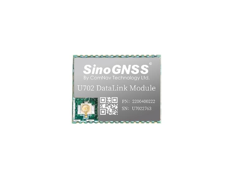
Comnav Technology has released the U702 datalink module, an RX/TX data link module that supports the LoRa modulation technique.
Its compact, surface-mounted design and robust electromagnetic compatibility enables easy integration into GNSS systems such as robotic lawn mowers.
With the LoRa modulation technique, the U702 has low power consumption, reception power of 0.025 w, and a working distance up to 1.5 km. It also enhances the ability to protect GNSS systems against various interference — making it possible to have high reception sensitivity, a low error rate, and high reliable data transmission even in harsh environments.
ComNav Technology’s K8 series GNSS modules can use the Galileo High Accuracy Service (HAS) precise-point positioning (PPP). The PVT algorithm upgrade to the K8 series module supports Galileo HAS with an accuracy of 20 cm horizontally and 40 cm vertically.
Galileo HAS provides free access to information necessary to estimate accurate positioning using a PPP algorithm in real-time through the Galileo signal E6-B and an internet connection. Galileo HAS Initial Service was declared on January 24, enabling users within the service area to achieve improved positioning performance.
The improved performance capabilities provide a higher level of accuracy for industries such as UAV, autonomous driving, intelligent transportation, agriculture and GIS collection.
A roundup of recent products in the GNSS and inertial positioning industry from the February 2023 issue of GPS World magazine.
SURVEYING & MAPPING
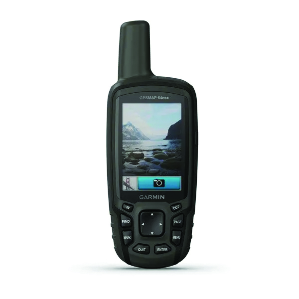
GPSMAP 64csx handheld GPS receiver (Image: Gamin)
Handheld GPS With navigation sensors and camera
The GPSMAP 64csx handheld GPS receiver comes with multi-GNSS support, TopoActive mapping, barometric altimeter, three-axis compass, and wireless connectivity via Bluetooth and ANT+ technology. It also has an 8 MP autofocus camera. The GPSMAP 64csx is built to withstand rugged terrain and is water-resistant. The highly sensitive receiver and quad helix antenna provide support from GPS, GLONASS and Galileo. Preloaded TopoActive maps include waterways, natural features, buildings and international boundaries. It is compatible with smartphones so users can receive email and text messages and share location data with others. Garmin, garmin.com
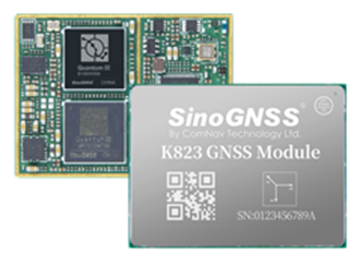
The Venus Laser RTK receiver comes with an inertial measurement unit. It can be used in its traditional mode with a range pole, or in laser mode without a pole, enabling GNSS surveying beyond typical limitations. In traditional mode, it has tilt compensation of up to 60° with an accuracy of 2.5 cm; in laser mode, it has the same tilt compensation but an accuracy of 5.5 cm. The receiver is powered by a SinoGNSS K8 high-precision module capable of up to 1,590 channels. It can survey using GPS, BDS-2, BDS-3, GLONASS, Galileo, QZSS and SBAS constellations. Other features include Bluetooth connectivity, more than 20 hours of battery life, and ruggedness (it is dust and waterproof and is designed to survive a two-meter drop). ComNav Technology Ltd., comnavtech.com
Leica iCON gps 160 (Image: Leica Geosystems)
Smart Antenna With features to increase productivity on the construction site
The Leica iCON gps 160 is a next-generation construction smart antenna designed to increase productivity in stakeout and measurement applications on the jobsite. It features a large color display with clear navigation for quick and easy setup without additional hardware. It is optionally available with an inertial measurement unit (IMU) for tilt-compensation functionality up to 20°. It seamlessly integrates with all Leica iCON construction instruments and controllers as well as the iCON field software for precise, real-time verification. Leica Geosystems, leica-geosystems.com
The Xsens Vision Navigator (Image: Movella)
GNSS inertial navigation Integrates position inputs from three high-accuracy sources
The Xsens Vision Navigator integrates position inputs from three high-accuracy sources including dual-antenna real-time kinematic (RTK) GNSS receivers; an inertial measurement unit (IMU) incorporating a three-axis accelerometer, a gyroscope and magnetometer; and a visual inertial odometry system. It can optionally accept input from an external wheel-speed sensor. The positioning sensor achieves centimeter-level accuracy when operating in GNSS mode with an RTK fix. When GNSS signals are not available, the product alone achieves accuracy of 2% of travel distance, or 0.75% when supplemented by wheel speed. Xsens Vision Navigator is suitable for outdoor positioning applications such as material handling equipment, commercial and specialist vehicles, last-mile delivery, inspection equipment and UAVs, agricultural equipment, mining equipment and utility robots. Movella, movella.com
SILC Eyeonic Vision System (Image: SiLC)
Coherent Vision Solution Delivers high levels of vision perception
The Eyeonic Vision System is a frequency-modulated continuous wave lidar solution, which delivers high levels of vision perception to identify and avoid objects with low latency. At the core of the Eyeonic Vision System is a fully integrated silicon photonics chip. It provides more definition and precision than legacy lidar solutions, with roughly 10 milli-degree of angular resolution coupled with millimeter-level precision. These features enable this solution to measure the shape and distance of objects with high-precision and at a large distance. The system combines the Eyeonic Vision Sensor and a digital processing solution based on a powerful field-programmable gate array. The flexible architecture enables synchronization of multiple vision sensors for unlimited points per second.
SiLC, silc.com
OEM
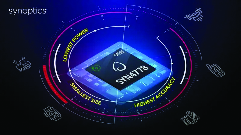
The SYN4778 (Image: Synaptics)
Integrated Circuit Designed for the internet of things
The SYN4778 is a small, low-power GNSS integrated circuit designed to extend battery life, reduce product size, and enhance performance of advanced location-based services for internet of things (IoT) devices — wearables, mobile accessories, asset trackers, UAVS and transportation devices. It includes advanced multipath interference mitigation using L5-band signals from GPS, Galileo, BeiDou, NAVIC, SBAS and QZSS. The chip also uses the L1 satellite band to reduce both the time to first fix, and the power consumed, improving the end-user experience and enabling product developers to add additional functionality and features to their IoT devices. Synaptics, synpatics.com
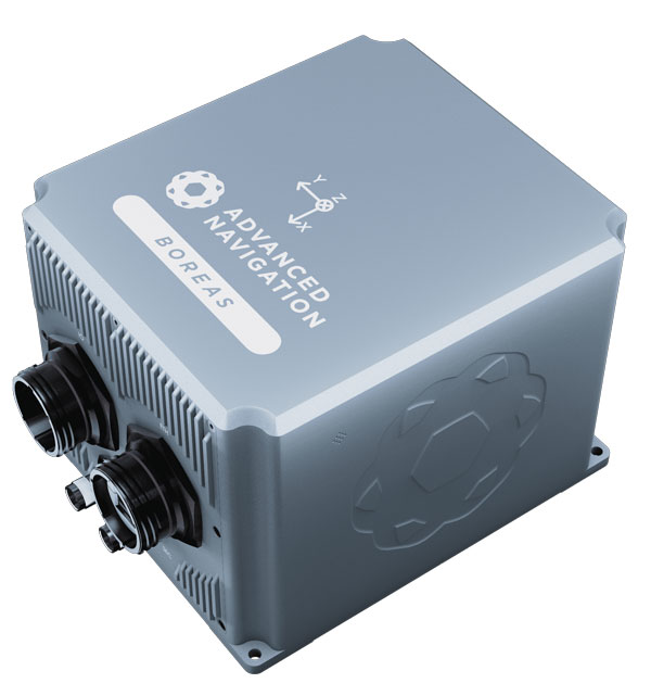
The Boreas D70 is a fiber-optic gyroscope (FOG) inertial navigation system (INS), part of the Boreas digital FOG series. The technology is suited to surveying, mapping and navigation across subsea, marine, land and air applications. It also could be adopted for vehicular applications, including autonomous vehicles and aircraft where weight and size are at a premium. The Boreas D70 combines closed-loop DFOG and accelerometer technologies with a dual-antenna real-time kinematic (RTK) GNSS receiver. These are coupled with an artificial-intelligence-based fusion algorithm to deliver accurate and precise navigation. Advanced Navigation, advancednavigation.com
The u-blox NEO-F10T (Image: u-blox)
Timing Module Dual-band and secure for 5G communications
The u-blox NEO-F10T offers nanosecond-level timing accuracy, meeting the stringent timing requirements for 5G communications. It is compliant with the u-blox NEO form factor (12.2 mm x 16 mm), allowing space-constrained designs to be realized without the need to compromise on size. The NEO-F10T is the successor to the NEO-M8T module, providing an easy upgrade path to dual-band timing technology. This allows NEO-M8T users to access nanosecond-level timing accuracy and enhanced security. u-blox’s dual-band technology mitigates ionospheric errors and greatly reduces timing error, without the need for an external GNSS correction service. u-blox, u-blox.com
TRANSPORTATION
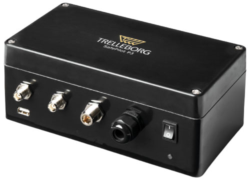
SafePilot P3 (Image: Trelleborg)
Maritime Systems Provides data on vessel positioning
The SafePilot P3 navigation system provides real-time data on vessel positioning and movement in tight waterways. It uses motion sensors and two GNSS antennas to measure the position and heading of vessels in three dimensions, minimizing time and difficulty associated with piloting procedures. SafePilot P3 has a backup battery to maintain functionality in the event of a power outage. This navigation system improves situational awareness while navigating waterways and ports globally, and also enhances communication between the captain, pilot, tug operators and canal personnel while vessels are transiting a canal and approaching a port.
Trelleborg, trelleborg.com
FusionEngine software (Image: Point One Navigation)
Positioning Engine Assures functional safety of ASIL-B
FusionEngine software, which is rated for automotive safety integrity level (ASIL), is now compatible with STMicroelectronics’ Teseo ASIL Precise Positioning GNSS chipset TeseoAPP. This assures functional safety of ASIL-B, a requirement for Level 3+ advanced driver assistance systems (ADAS). It can be integrated into several different host processors to enable high-level ADAS and autonomous driving systems. The combination of TeseoAPP’s receiver and the STA5365S external RF front-end provides dual-band measurement data for all visible GNSS satellites to the main host processor into which
FusionEngine is integrated. Point One Navigation, pointonenav.com
Ghost Autonomy Engine (Image: Ghost)
Autonomous driving software for level 4 driver assistance
The Ghost Autonomy Engine achieves the reliability required to bridge the gap between driver assistance capabilities L2 or L2+, and self-driving that does not rely on a human backup (L4). The software provides a stereo-vision neural network that delivers per-pixel depth in real time. It is capable of detecting and segmenting key features in a scene without needing to classify or recognize them. The physics-based perception system can handle the long tail of obstacles on the road, even those never seen before. Ghost, ghostautonomy.com
Vista-X120 Plus (Image: Cepton)
Lidar Provides 3D perception
The Vista-X120 Plus is a slim automotive lidar device for real-time adaptive 3D perception for advanced driver assistance. Its software-definable region of interest enables higher dynamic perception capabilities, while an adjustable central field of view with increased angular resolution improves accuracy in detection and classification of objects when driving. The region of interest is also configurable in real time in both horizontal and vertical directions. The Vista-X120 Plus is compact at 140 mm x 30 mm, improving OEM integration and placement options without disrupting vehicle appearance. Cepton, cepton.com
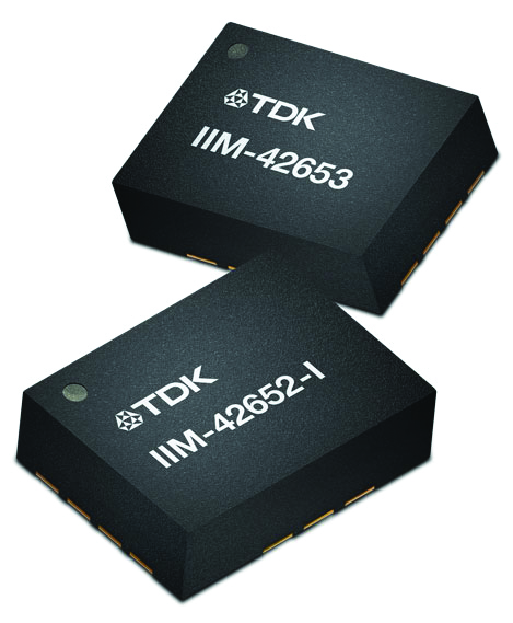
IIM-42653 and IIM-42652-I sensor platforms (Image: TDK Corporation)
Sensor Platforms Targets industrial and navigation applications
The IIM-42653 and IIM-42652-I sensor platforms consist of 6-axis IMUs, which target industrial and navigation applications requiring high force sensitive resistor (FSR) performance or inertial navigation software. The IIM-42653 platform — a robust, low-noise, low-power, 6-axis IMU — is capable of a gyro-programmable output of 4,000 dps and an accelerometer-programmable output of 32 g. These features make the IIM-42653 suitable for industrial-grade or high-end automated guided vehicles, automated mobile robots and unmanned aerial vehicles. The IIM-42652-I platform offers hardware authentication and can be integrated with TRACK dead-reckoning software from Trusted Positioning. TRACK filters GNSS multipath errors and provides a continuous navigation solution when GNSS signals are unavailable. TDK Corporation, invensense.tdk.com
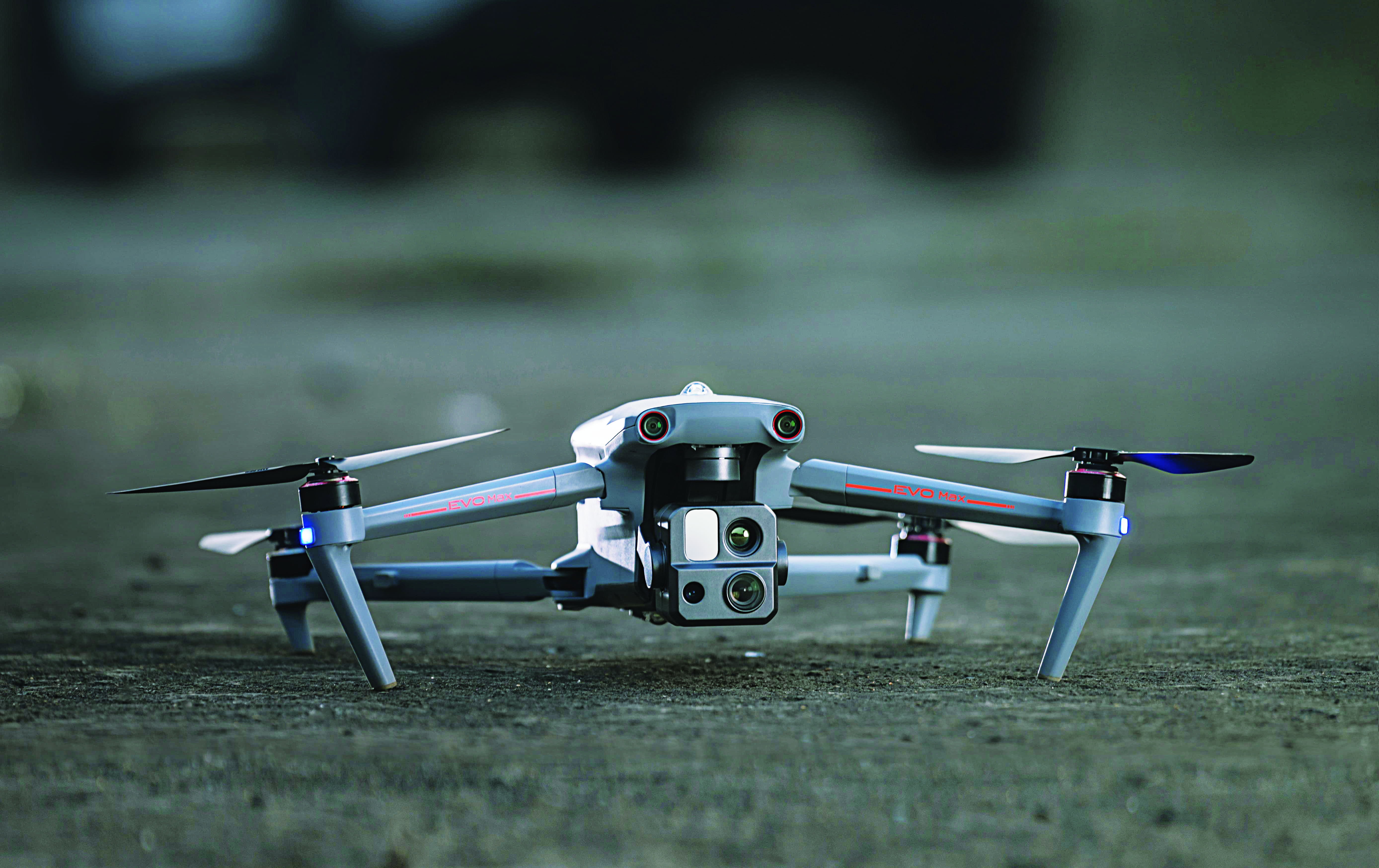
VO Max 4T (Image: Autel Robotics)
Flight Platform
For enterprise and professional applications
The EVO Max 4T autonomous flight platform provides omnidirectional obstacle avoidance and tri-anti-interference capability to ensure flight safety and stability in high-interference environments. It is equipped with three high-quality cameras including a 48 MP telephoto camera, a 50 MP wide-angle camera and an infrared camera. The platform has a range of navigation and data-acquisition functions, including 3D flight routes, PinPoint Mode, Team Work, Polygon Mission, Waypoint Mission and Oblique Photography. EVO NEST is a base for automatic take-off, landing, charging and mission planning for EVO series UAVs. It is designed for all-weather operation and can be easily transported. Autel Robotics, autelrobotics.com
The average age of surveyors in the United States is nearly that of retirement. Can new technology attract a new generation to the profession?
“We do not fully understand the trend in the United States,” said Simon Peng, ComNav Technology, “but in China we find that modern survey technology — such as UAV/lidar mapping and total stations — make field work simple. New trends such as computer imaging, point clouds and building information models (BIM) attract young surveying engineers.”
Using the equipment in the field is becoming increasingly easier, said Bernhard Richter, Leica Geosystems. “Our goal is that operating the field equipment should not be more difficult than playing with your smartphone. That means that you don’t need the super expert in the field so much anymore.” However, he argued, “someone who studied surveying should now be more the data manager, have the expertise to put the data in geospatial relation, and know in which reference frame he is operating.”
For example, that person needs to know about orthometric and ellipsoidal heights, especially for engineering projects between countries that might have different height codes. “Anybody who has an interest to geolocate an object can capture the data and upload it to the cloud environment,” Richter said. “Then there are the data managers. Certainly, they need to know the physical limits of surveying technology, and they need to manage the complexity of modeling Earth. They need to become data managers to really put data to work.”
“The anticipated number of new professionals is not necessarily replacing all the surveyors who are expected to retire over the next 10 years,” said Boris Skopljak, Trimble. To tackle this challenge Trimble is using a two-pronged approach: attracting younger workers by raising awareness of surveying as a future career and modernization of the profession. For the first prong, Skopljak cited “phenomenal programs out there, such as Get Kids into Survey.” He pointed out that many Trimble employees are part of those education programs, “promoting inclusion of not just a younger generation, but also of women and minority groups that are heavily underrepresented in our industry today.”
For the second prong, “Digital data capture workflows present opportunities. A very common interview question we ask these days is ‘Do you play video games?’ Generally, those young professionals who are gamers thrive in the 3D environment. The technology aligns well with the interests of younger folks.”
Additionally, a growing number of educational institutions are evolving their curriculums to meet these needs, said Skopljak. Trimble is establishing Trimble Technology Labs in selected academic institutions around the world that are helping students access the latest technology and the best modern engineering practices. Boosting productivity also helps compensate for the declining number of surveyors, because it reduces the number of people needed to get the job done. “As the technology becomes easier to digest and operate and more focused on the workflows, it also becomes easier for companies to standardize it and attract talent,” Skopljak said.
One of the biggest threats to the survey profession, according to Huff, is that it “let bits and pieces of traditional surveys fall off to the wayside.” Geographic information systems (GIS) use the same positioning technology, he pointed out. “Fifty years ago, that was more of a function of the surveyor than it was necessarily the GIS profession. In many ways, while the surveyor is aging — the licensed cadastral surveyors certainly are aging — there is a new generation of folks coming through who are leveraging the new technology, such as drones and mobile mapping systems.”
This new generation, Huff argued, will achieve the same accuracies as the previous one partly because it’s getting easier to do so. “We definitely have more of a generation of digital users that can leverage the technology to do things where even my mentors performed many calculations by hand, on the fly, from plain tables in their logbooks with sine, cosine and tangent in them. Now, I think that technology and 3D immersive technology, which hinges on GPS location, attracts a younger crowd to certain facets of the profession.”
François Freulon, Septentrio, agreed that new technologies now available “can be easily adopted by new generations in the profession,” yet added that “quality surveying requires a good formation and experience in the field.” Therefore, he argued, “surveying education systems will need to adapt their programs and incorporate newer techniques such as new positioning modes and corrections.
Surely RTK remains as the main accuracy technique, but this could change quickly in the coming years as correction services bring better performance and regional coverage.”
Advances in GNSS technology constantly expand the range of projects that benefit from them.
ComNav Technology
A telecom company adopted its CORS station to build China’s national CORS service for public companies. It is increasingly used for field robotics, including the development of self-driving cars.
Leica Geosystems
Bernhard Richter, vice president of Geomatics, Leica Geosystems AG, pointed to one of the biggest infrastructure projects in Europe, which aims to connect London to Birmingham, Manchester and Leeds with a high-speed railway system, avoiding the need to fly between those cities. This will have great environmental benefits because high-speed trains are much more efficient than planes.
However, high-speed rail requires tremendous precision. “First comes the prep work, moving dirt,” said Richter. “Then you must install the railroad ties with tenths of a millimeter precision relative to each other to avoid side accelerations. For a surveyor, it really has everything in one project. You need to constantly work with civil engineers. You then try to build as much as possible with machine-control-guided systems to make the leveling as automated as possible.” The project will include building bridges over whole valleys and monitoring them, particularly during the construction phase, to ensure that they are not moving.
“Even the factory they are building is huge, so just to build the factory you need a lot of surveying,” Richter said. The project is generating 25,000 jobs at 300 construction sites, all of which must be managed on very tight schedules. In this context, the quality of the survey gear is critical. “On a construction site, the surveyor should be an invisible person,” Richter said. “When they come with the big machines and want to get stuff done, they don’t want a surveyor on the site. So, he has to work off hours, then remain on alert and trust that what comes out of an instrument is correct.” Leica Geosystems is one of the main suppliers for this project. “They chose us because of our focus on reliability, trust and quality.”
Trimble
Software is increasingly driving sales, pointed out Boris Skopljak, vice president, Surveying & Mapping Strategy and Product Marketing at Trimble Inc. As an example, he cited Trimble’s SX12 scanning total station, which uses Trimble Access software to leverage scanning, imaging and traditional total station capabilities in the field. “We have provided more inspection tools to enable people to decide whether something is meeting the tolerance.” The Trimble Connect cloud-based collaboration platform, coupled with the continuous field and office connectivity, has driven productivity increases and moved customers toward choosing the company’s solutions, he said.
As an example of Trimble solutions, Skopljak cited City Rail Link, New Zealand’s first underground rail network and the largest transportation infrastructure project ever undertaken there. “The Trimble R10 was integral to acquiring static observations above the work site, while the Trimble S9, DiNi and Trimble Business Center network adjustment were game changers for the survey control network,” he said. To expedite mine tunneling the surveyors used the SX12’s combined total station and scanning functionality with Trimble Access field software infield inspection tools. “Fewer customers are choosing solutions on a spec. It’s not about how many satellites you can track, for how many days, or how many points you can scan. They are choosing solutions based on the ecosystem and productivity.”
Land surveying is an ancient practice, dating back at least 5,000 years to when Egyptian rulers used it to tax land plots. Over the centuries, it has been repeatedly transformed by new technologies — the compass (about 200 B.C), the theodolite (1550s), Gunter’s chain (1620), the sextant (1757), electronic distance measurement (1950s), and total stations (1970s). Then came GPS, followed by the other GNSS and corrections services.
Now comes sensor fusion, which aims to compensate for the limitations of GNSS — orbit and satellite clock errors, ionospheric and tropospheric delays, multipath, dilution of precision, urban canyons, jamming, extremely weak received signal, etc. — by integrating it with other sources of positioning data, including inertial measurement units (IMUs), lidar sensors and cameras. Even crowdsourced geolocation data collected with cell phones help expedite surveys by guiding surveyors to landmarks.
In the following article, representatives of five companies share their perspectives on recent advances in surveying and the remaining challenges.
Many More Satellites
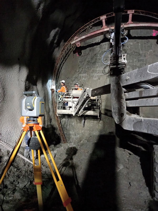
City Rail Link is New Zealand’s first underground rail network and the largest transportation project ever undertaken there. In this photo, taken at Karangahape Station, the Mined Tunnel Team installs a lattice girder secondary support structure using a Trimble SX12. (Photo: Link Alliance)
Compared to just a few years ago, there are many more GNSS satellites, signals and options for correction services. Over the past decade, the average number of satellites in view has more than doubled to more than 40 today. Some parts of the world have more than 70 satellites in view, said Boris Skopljak, vice president, Surveying & Mapping Strategy and Product Marketing at Trimble Inc.
“The developments in GNSS field systems have always been geared toward simplifying workflows, improving accuracies and increasing productivity,” Skopljak said. “In the last few years, we’ve seen that on a massive scale. In some of our materials, we no longer even quote how many signals our GNSS receivers are tracking.”
The vast increase in the number of satellites has extended high-precision applications to the robotics and automotive markets. The challenge now is “position solution,” not just GNSS, said Simon Peng, director of the Overseas Department at ComNav Technology. The improvements in the satellite constellations, antenna technologies and algorithms also enable surveyors and other users to obtain results faster and to operate in environments previously impervious to GNSS, such as under heavy canopy and very close to buildings.
“Our customers can now operate in environments where there is no virtual reference station (VRS) infrastructure or real-time kinematic (RTK), by leveraging precise point positioning (PPP) solutions, such as the Trimble RTX corrections service,” Skopljak said.
“Additional satellite signals and constellations (like Beidou),” Skopljak said, “improved antenna technology and continuously evolving algorithms are contributing to improving the RTX accuracy while bringing the convergence times to almost instantaneous in normal conditions and making technology available in more regions.”
“When I first started surveying, if we had a 12-channel receiver, that was doing very well,” recalled Jesse Huff, head of Sales and Marketing, JAVAD GNSS. “Now, we’re tracking 36 birds in the sky at one time with an 874-channel receiver. That’s phenomenal.”
Huff described a patent-pending feature called real-time post-processed kinematic (RTPK). “It combines RTK, PPK and PP techniques, with multiple core processing engines and a single solution coming out of that. It is impressive standing underneath a giant oak tree and surveying that monument with GPS and knowing what your accuracies are. We’re not even chasing RMS values; we can report the actual positional uncertainties, which is amazing.”
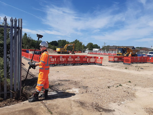
Pole tilt compensation enables surveyors to precisely and easily localize points that are difficult or dangerous to access. (Photo: ComNav Technology Ltd.)
“With so many signals and the new ways of how we compute positions based on PPP technology, we can almost globally get to centimeter-level positioning within a couple of minutes from just one global correction link,” said Bernhard Richter, vice president of Geomatics at Leica Geosystems AG, part of Hexagon. “Under optimum conditions, you can have almost an instantaneous global accuracy of a couple of centimeters.” In mature areas, he added, a local RTK network infrastructure enables achieving centimeter accuracy within a couple of seconds.
Galileo, Richter pointed out, will be fully operational in 2023 with great signals, though he’s “a bit skeptical” about the system’s target date for its high-accuracy service. “So, we will basically get global constellation corrections that allow us also centimeter-level positioning.” BeiDou has been fully operational since 2020. “GLONASS is more unpredictable,” Richter said. “It looks like modernization is slowing down a bit, in particular the CDMA developments.” Additionally, he pointed out, it is possible that one or more governments may decide not to use those signals, for military or political reasons. “It’s not the manufacturers who decide which signals to take.”
“In open-sky conditions, additional satellites have added redundancy — which is always good for position integrity — but it’s only when obstacles start to appear on the horizon, blocking out parts of the sky, that all-in-view RTK really comes into its own,” said François Freulon, Head of Product Management at Septentrio. When they did not have a full view of the sky, he recalled, GNSS users used to have to carefully schedule their work to coincide with times of high satellite visibility. “Nowadays, by using multiple constellations and signals, RTK can reach the parts that receivers in the past could not tread. More signals and constellations have also helped in easing the collection workflow for surveyors, making the capture of data in difficult conditions much quicker and more efficient.” New correction services are further simplifying the workflow “thanks to new positioning techniques, pricing business models and simplified network density.” However, corrections companies still face challenges in ensuring that centimeter accuracy can be uniformly achievable at a global scale.
Sensor Fusion
The ongoing evolution in computing power and communication technology “leads to many more sensor combinations,” Skopljak said. “We are not talking about GNSS alone anymore. We are talking about integrating a GNSS antenna, a receiver, an IMU, power and communications into a single compact housing.” The integration of inertial sensors makes it possible to localize the instrument rod tip when the pole instrument is tilted. “That allows our customers to measure more safely in dangerous environments.”
“We are reaching a maturity stage of what we can do only with GNSS,” said Richter. “It’s all about sensor fusion. The problem when signals are obstructed, that’s not solved, even though we can do positioning from Wi-Fi hotspots or from local pseudolites.” So, fusing data from cameras, lidar, GNSS and IMUs in better ways is the way to go and presents “a huge open research ground.”
For Richter, the challenge is not just positioning, the orientation of objects is almost as important as that, especially for such tasks as machine control. “It’s also about what you do with the data that you collect. Hexagon’s vision is of an autonomous future where we put data to work in connected ecosystems to boost efficiency.” However, he pointed out, this requires large amounts of data, such as those from aerial photogrammetry, lidar and mobile mapping systems used to create city models and digital twins of buildings. “If you really want a car to drive autonomously through a city with all the things that could happen, you must rely on a perfect replication of the real world,” he said. Other examples he cited are more efficient evacuation plans and flooding simulations. “GNSS will never be enough, but it will always be a very good enabler because it works.”
Classes of Receivers
JAVAD GNSS designed its TRIUMPH-LS Plus receiver to work under heavy tree canopy. (Photo: JAVAD GNSS)
Two decades ago, we would often group GNSS receivers by accuracy into three buckets: consumer grade, resource or mapping grade, and survey grade. As accuracy has increased for all GNSS receivers, the boundaries between those categories — especially between mapping and surveying — have blurred. “The performance of GNSS has increased so much that we are not using the traditional accuracy-based differentiation between surveying and GIS,” said Skopljak. “For mapping professionals, 10 years ago it was all about points, lines and polygons; now it is all about locating assets and adding the most accurate positions as attributes to those assets. For our survey and engineering customers, what matters is still geometry and working with the models to serve the connected construction in the field.” As for the pure GNSS technology stack, “we are seeing fewer differences between mapping and surveying receivers, but we are focusing on serving the customer in terms of product-as-a-service or as a productivity tool.”
Huff made two points. First, that “survey grade” does not necessarily equal RTK. “Some education needs to happen so that people understand RTK as a technique, not an accuracy. You can get poor accuracy and poor fixes with RTK, even when you’re using good techniques. So, when I say ‘survey grade’ I’m still talking about the full frequency receivers, using all available signals.” Second, that consumer-grade receivers, such as the chipsets in our phones and computers, do not require the same robustness as professional ones. “While they may be achieving the same precision, surveyors must be able to defend their position in a court of law.”
Huff cited the “phenomenal” success of the simultaneous localization and mapping (SLAM) movement with all kinds of positioning challenges. “From a survey perspective,” he said, “we’re dealing with a much more feature-rich dataset than we were even just 10 years ago, with everybody having some type of GPS device on their phones. There are location tags on everything. That creates evidence for the surveyor to be able to go out and recreate things, reduce trips to the field, reduce rework times — all those things that make a surveyor’s life much easier.”
Surveyors now can fly aerial surveys of hundreds of acres in less than half an hour using drones with RTK, Huff said, instead of having to wait for the flying season with traditional airborne photos. If needed, they can pick a few ground-control points for ground truthing. “We’re able to do that with photogrammetry techniques, but using GNSS technology to position drones, whether it’s real time or post-processing, has definitely made surveying jobs easier.”
Correction Services
The adoption of GNSS in construction is growing and receiver manufacturers are making it easier to use their equipment in the field. (Photo: Leica Geosystems)
Correction services — such as satellite-based augmentation systems (SBAS), the ground-based Wide Area Augmentation System (WAAS) and the European Geostationary Navigation Overlay Service (EGNOS) — make a big difference along with PPP and similar techniques when base stations are not available. “We have the whole CORS network here in the United States,” Huff pointed out. “We also have services available from the National Geodetic Survey.”
Those who don’t want to have to fully engage in post-processing can upload their data to the Online Positioning User Service (OPUS), AUSPOS (a free online GPS data-processing facility provided by Geoscience Australia) or other corrections services that will post-process positioning data. “It has made it more accessible for all the surveyors all the way around, especially as the technology has improved and the cost barrier to entry into a survey-grade GPS receiver has come down significantly as well,” Huff said.
Growing Adoption of GNSS
The greater number of satellites in orbit significantly reduces convergence time and increases the accuracy of the solution, which makes the technology much more user-friendly for professionals and nonprofessionals alike.
For surveyors and mapping professionals, the increasing levels of GNSS performance means that “GNSS continues to be the dominant equipment and they can operate in challenging GNSS environments while still meeting the accuracy and precision requirements,” Skopljak said. GNSS usage is also growing in such industries as agriculture, construction, transportation and logistics. “Now, when farmers are on a combine, they don’t have to wait for an RTX or PPP solution to converge for 20 minutes. The solutions just work, and they can perform their task.”
Skopljak also pointed to “more flexible business models, such as pay-as-you-go or equipping seasonal workers or fleets of spatially enabled consumers to use GNSS,” that reduce the required upfront investment. “Surveyors now can go for longer and be productive in more areas where they could not use GNSS technology before. The non-surveying professionals — such as in natural resources, farming or construction — now can just turn on the machine and things work for them. They don’t have to worry about coordinate transformations and things like that.”
“Twenty years ago, when RTK and networks kicked in and then became popular, we were discussing whether it was the end of the automated total station,” Richter recalled. “Yet, the number of automated total stations has grown ever since.” To him, this is proof that GNSS alone will never solve all surveying problems. GNSS’ weak signal will always require surveyors to supplement it with other sensors, such as reflectorless total stations. “These instruments always need to work in harmony,” Richter said.
Success on both construction sites and in machine control require a very good robotic total station and a very good GNSS receiver, Richter said. “The simple problem of leveling a pole is actually solved, and we are using the technology that we developed for tilt-compensating GNSS receivers. We’re leveraging this now into the world of the total station.” This has solved one of the fundamental problems surveyors have long had, because they no longer need to level up and can measure tilted poles with a total station and with a GNSS receiver. “We have also made it very seamless for surveyors to switch between using GNSS receivers and total stations,” Richter said.
ComNav Technology has introduced its new-generation data collector, the R60. The powerful handheld has an ergonomic design and runs on Android 12 OS, providing a suitable workhorse for surveying professionals in the field.
Survey Master field software works seamlessly on the R60, which features a Qualcomm 8-core processor for massive data processing. Its 64-GB memory allows ample data storage and enables the opening of CAD drawings in seconds. A full QWERTY keyboard speeds up surveying efficiency.
The 9000 mA Li-ion battery provides more than 30 hours of continuous functioning and is fast charging, taking only 5 hours to fully charge with the USB-C interface port.
The 5.5-inch sunlight-readable, high-resolution screen provides a smooth and comfortable experience in outdoors. The IP67 dustproof and waterproof rating protects the R60 from most harsh environments.
The R60 data collector now is available through ComNav Technology authorized local distributors or ComNav Technology directly.
ComNav Technology now provides a GNSS high-precision positioning solution for navigation and positioning of autonomous lawn mowers. Environmentally friendly and intelligent robotic lawn mowers are growing more popular, making the mowing task easier, safer and more convenient.
R&D background
It is difficult to develop autonomous lawn mowers because they obtain navigation information by means of visual and acoustic sensors, usually through embedded cables in the working area and detection through eddy current sensors. The shortcomings are obvious: before the mower starts, it must be set up with cables and other equipment. Cable requirements differ in various countries, and cable laying can be complicated, wasting resources and money.
With these difficulties in mind, ComNav applied its K8 series of GNSS high-precision modules to lawn mowers to break through the application limit. It solved this accuracy problem to make the lawn mower achieve centimeter-level driving according to the setup path in an open field. With ComNav’s other technologies — quantum algorithm and LAI, HighLock, PPP, RTK-KEEP — the law mowers continues to operate under trees, around corners or in other obscured areas.
Introduction of ComNav’s solution
With the K8 series module, ComNav facilitates the lawn mower’s fieldwork with position data provided by GPS, GLONASS, Galileo, Beidou, QZSS, IRNSS and SBAS.
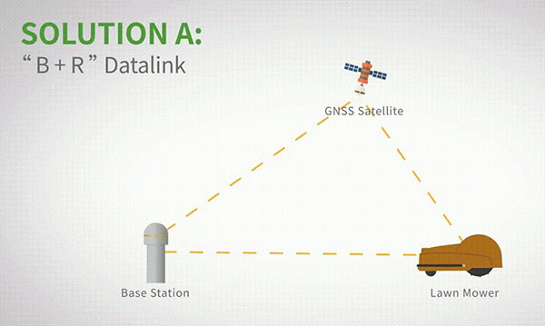
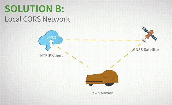
The high-precision positioning system for lawn mowers consists of a base station and a rover station. Three solutions are recommended for the terminal to obtain differential data from the base station.
Base and rover datalink. A base station acquires differential data through a datalink and provides corrections to the rover. The rover station — comprising the parts installed on the lawn mower, including the GNSS antenna, the GNSS high-precision module, datalink and UHF antenna — enables centimeter-level positioning and navigation.
Image: ComNav
Local CORS network. Utilizing existed local CORS, the rover station obtains differential data from the CORS service, enabling the lawn mower to achieve positioning and navigation accuracy on a centimeter level.
Image: ComNav
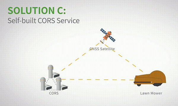
Self-built CORS network. Base stations can be placed anywhere based on requirements. Doing so eliminates the worry about prevailing conditions and makes high-precision positioning and navigation of lawn mowers possible.
Image: ComNav
Technology Features
LAI technology. ComNav’s patented low-power anti-interference (LAI) technology provides a jamming-to-signal ratio of up to 50 dB. Power consumption is only 0.1 W when turned on. By quickly detecting and eliminating interference with simple settings, LAI technology can reduce failure time and ensure safe operation. The technology can generate a spectrum diagram of interference sources, enabling identification of interference types and potential interference sources.
Quantum algorithm. ComNav’s quantum algorithm has sophisticated technology for detecting and repairing cycle slips. It uses full-constellation and full-frequency tracking capabilities along with multi-frequency combination, model and parameter estimation. Quantum is able to eliminate errors caused by the ionosphere, the troposphere and multipath in seconds. As a result, the initialization time of real-time kinematic (RTK) is greatly shortened and precision and reliability are improved. Meanwhile, the extra-long baseline calculation capability expands the operation range.
RTK-KEEP technology. By estimating model and parameter values, RTK-KEEP Technology can reduce errors caused by satellite orbit, clock difference, ionosphere and troposphere when the base station’s data is lost. Centimeter-level accuracy can be kept for more than 10 minutes, greatly improving the availability of RTK.
Benefits of ComNav’s Solution
ComNav’s solution allows the lawn mower to achieve centimeter-level positioning and reduce mowing repetitions. It helps the lawnmower to operate safely and reliably in the corners, under trees, or in other places where satellite signals are weak or lost. With its strong anti-interference capabilities, the lawn mower can maintain continuous and effective positioning in complex environments, meeting the needs of a variety of applications.
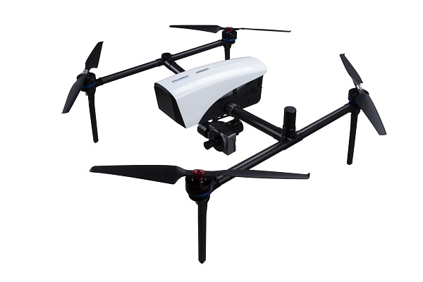
ComNav Technology has released a powerful and reliable UAV aerial mapping solution capable of centimeter-level positioning, providing high-precision photos and data for mapping professionals.
Based on the company’s K8 platform, the package consists of an E300 real-time kinematic (RTK) drone, flight-control software and an optional camera.
Featuring high accuracy, strong compatibility, long endurance, high performance and an easy workflow, the E300 drone package can meet the requirements of many different applications, including topographic survey, urban construction, forestry investigation, emergency rescue, 3D modeling, mining and surveying.
High Accuracy. The E300 RTK drone is embedded with a high-precision K8 GNSS module that supports GPS L1/L2/L5, BeiDou B1/B2/B3/B1C/B2a, GLONASS L1/L2, Galileo E1/E5-a/E5-b/AltBOC/E6 and QZSS L1/L2/L5. With Quantum III technology, the K8 GNSS module provides reliable and stable RTK positioning results.
The professional post-processed kinematic (PPK) software Compass Solution supports the full-constellation calculation, providing accurate positioning results.
RTK/PPK provides dual backup, one as a failsafe for another, to ensure acquisition of data. The built-in antenna further increases precision of photo position. EVENT synchronization technology can reduce camera trigger error and ensure high performance of the solution.
With its intelligent recognition algorithms, the E300 is able to capture high-resolution images consistently even in complex environments.Moreover, the E300 has a multipath redundancy design with key modules for safety.The solution can provide centimeter-level positioning results without ground control points, saving time.
Compatibility. Featuring a carrying capacity of 3 kg, the E300’s payload bay is compatible with a wide range of cameras, including C20, C50, LiAir VH2 and others. Payloads can be quickly and easily swapped in the field for maximum versatility.
Besides supporting standard NTRIP protocol, the E300 is compatible with all brands of base stations and continuously operating reference stations.
Long Endurance. The E300 is characterized by an ultra-efficient aerodynamic design. It reaches a 60-minute flight time without payload and 50 minutes with a basic payload, covering areas with a maximum 10-km radius per flight. In one flight, the E300 can map about 0.62 km² in 1.5-cm/px ground sample distance with one battery.
The E300 RTK drone features a simplified design for easy and rapid assembly within minutes while providing excellent stability and vibration resistance.
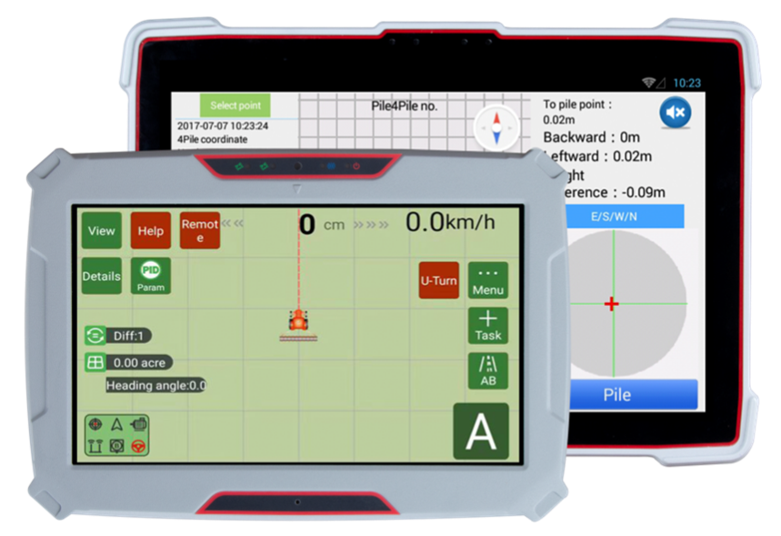
ComNav Technology has released the P300 Series GNSS tablet to the global market. Based on the company’s K8 GNSS OEM platform, the high-precision in-cab Android rugged tablet brings innovative performance and ease of use to various operations in precision agriculture, autonomous driving, machine control and other industries, the company said.
Embedded with the new-generation K8 OEM module, the P300 series GNSS tablet can track all current and planned constellations (including GPS, BeiDou, BeiDou-3, GLONASS, Galileo, QZSS) and reach centimeter-level accuracy. Using the advanced Quantum III technology in combination with upgraded SinoGNSS ASIC chip and advanced microprocessor unit, the P300 series is capable of providing enhanced heading and positioning performance for everyday field use.
Photo: ComNav
Features of the P300 include dual-card, dual-standby, various interfaces, multiple wireless connections and data transmission modules for CAN, PPS and Event. The P300 can adapt to a variety of application scenarios to meet different needs of users. The aluminum-magnesium alloy body makes the P300 robust, able to cope with the rigors and demands of tough construction jobs and strenuous vibrations.
The P300 series runs the Android operating system and is compatible with most Android apps. Compared to traditional GNSS receivers the high-definition color touchscreen and intuitive interface make it easy for both beginner and advanced users to operate.
The P300 series tablet includes P300 Plus (10.1-inch) and P300 Mini (8-inch). Both deliver the same high performance, user-friendly design, powerful connectivity and rugged construction to users. Both sizes are available now.
ComNav’s high-accuracy PileMaster sped construction of the Aarah Resort in the Maldives. Photo: LANKA Foundation and Piling Services Pvt. Ltd.
The construction of the Aarah Resort in the Maldives involved building 64 luxury water villas and 12 beach buildings on a shallow-water area with about 1,400 piles. LANKA Foundation and Piling Services Pvt. Ltd. was able to complete the piling project in only 32 days by using a high-accuracy piling solution from ComNav Technology Ltd.
The traditional piling approach requires many surveyors to stake out the positions of the piles underwater in advance. Not only is this process labor-intensive, it also creates a real-time problem: even if the coordinates are measured accurately by lofting, the primary coordinate markers are soon out of position due to the movement of the piling machines. The stakeout’s accuracy is also threatened by strong waves, ocean currents and coral reefs. Furthermore, in the subsequent piling process, the piling accuracy is reduced due to artificial aiming. During the whole process, surveyors must work in the water and fix the piles at short range, which is dangerous. For these reasons, the traditional piling approach is a low-efficiency, high-cost and high-risk operation.
Photo: Google Earth
ComNav’s professional positioning solution for high-accuracy piling provides a 9-inch high-resolution tablet with an integrated GNSS receiver, a T300 GNSS receiver as the base station, and two AT340 antennas with magnetic mounts combined with PileMaster software. Its integrated GNSS receiver tracks GPS, GLONASS and BeiDou signals, enabling the system to work even in challenging environments. The system can acquire real-time kinematic (RTK) corrections via an internal UHF transceiver from the T300 receiver or connect to a local continuously operating reference station (CORS). Moreover, PileMaster is designed with an intuitive interface with clear element-management capability, supporting import of up to 10,000 points from Excel, TXT and CAD formats to meet the specific demands of a high-accuracy piling project.
Compared to the traditional piling method, ComNav’s intelligent control system for piling is an all-weather, high-accuracy solution with the additional advantages of being widely compatible and easy to manage. Through software system control and real-time processing and display, it can greatly reduce the number of surveyors required on-site. The system can guide users to the location, shorten the construction period, save construction costs, and enable intelligent visualization and monitoring to ensure high-precision construction work.
After a first successful application in 2017, Foresight Surveyors Pvt. Ltd, ComNav’s local partner in the Maldives, used the solution in many projects, including construction of the Kunaavashi Resort & Spa in 2018 and the Kuda Villingili, Dhigufaru Island and Maniya Faru resorts in 2019.
ComNav Technology Ltd. is providing GNSS technology to Africa for projects in land mapping, continuously operating reference station (CORS) construction, precision agriculture and other fields, according to a Feb. 11 article in People’s Daily, the largest newspaper in China.
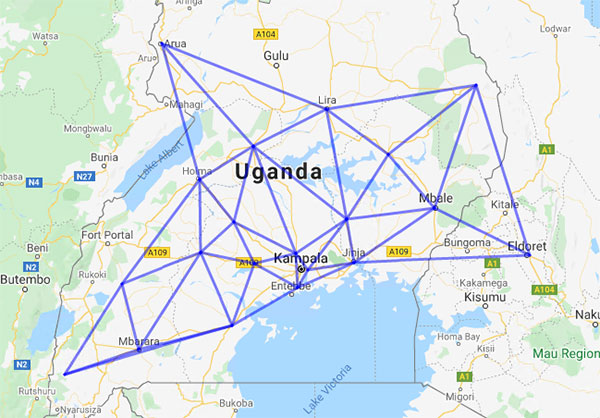
Every day, thousands of users in Africa are using GNSS products, the newspaper stated, highlighting specifically the use of China’s BeiDou satellite navigation system. For instance, CORS using ComNav GNSS/BeiDou receivers have been built in 11 sub-Saharan African countries, including Kenya and Uganda.
Uganda. To meet the demand for high-precision GNSS, the government of Uganda purchased ComNav’s real-time kinematic (RTK) receivers to build its own CORS. Thirty stations have been built so far, creating the most advanced CORS network in East Africa. Its high-precision spatial and temporal information supports land mapping, mining, vehicle management and meteorological monitoring, among other industries.
In 2015, Mulindwa David, chairman of the Uganda Surveying Association, and others visited the Shanghai headquarters of ComNav to learn about its high-precision products and technologies. After training, David and others mastered basic RTK operation and learned simple maintenance.
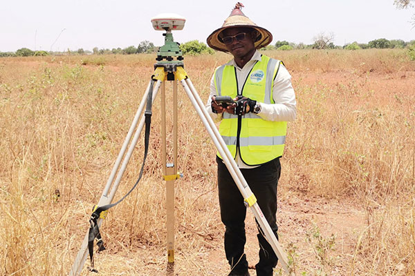
David used to carry heavy optical equipment every day, but now he only needs to hold a BeiDou receiver to process the relevant data, which has greatly improved his work efficiency and accuracy. “It took at least three days to survey a dozen kilometers of road with optical equipment,” he said. “With BeiDou high-precision receivers, only 10 hours is enough.”
The Uganda CORS network. (Image: ComNav)
Burkina Faso. In response to the COVID-19 outbreak, the Burkina Faso government decided to build a hospital for infectious diseases. In April 2021, it used ComNav GNSS high-precision technology to provide survey data for the hospital’s construction. The land security and topographic surveying tasks were completed in six days, half the time scheduled, said Augustin Bamouni, secretary-general of the country’s national surveying association.
A surveyor in Burkina-Faso surveys the site of a new hospital for infectious diseases. (Photo: ComNav)
Tunisia. The China-Arab BeiDou/GNSS Center is located in the Ghazara Science Park in northern Tunis, the capital of Tunisia. Inaugurated in 2018, it is China’s first overseas BeiDou center, providing satellite navigation training, test evaluation and technical research for African and Arab countries. On average, the center receives real-time data from more than 12 BeiDou satellites at once.
The center will help Tunisia and other African countries train professionals in GNSS technology to support development of the digital economy, according to Amiri Khalil, state secretary in charge of scientific research at Tunisia’s Ministry of Higher Education.
China-Arab BeiDou/GNSS Center is in Tunis, Tunisia. (Photo: ComNav)
China-Africa Forum. The first China-Africa BeiDou System Cooperation Forum was held in November 2021 in Beijing to encourage cooperation between China and Africa and promote use of BeiDou. Four cases from ComNav Technology were described in the forum’s document citing application scenarios of BeiDou in Africa.
ComNav Technology has deepened its cooperation with Africa since China’s Belt and Road Initiative began in 2013. Besides providing products and technologies, ComNav arranged employees to go abroad to provide technical support, traveling to Cameroon, Nigeria, Mali, Zambia, and other African countries. Despite the pandemic, ComNav continues to provide professional service and training both in person and remotely.