The National Association of Broadcasters (NAB) has launched Merkhet Solutions, an independent company focused on the commercial deployment of the Broadcast Positioning System (BPS).
BPS, first conceived by the technology team at NAB in 2021, is a patented terrestrial, GPS-independent timing and positioning technology that leverages the high-power, geographically diverse broadcast infrastructure already covering the United States.
BPS has been designed to address the more than $1 billion-per-day economic and national security risk posed by overreliance on GPS. Merkhet Solutions is engaging across critical infrastructure sectors, including energy, data centers, telecommunications and financial services – where a loss of precision time can trigger grid instability, outages and lost trades.
“BPS represents a powerful intersection of innovation, public safety and opportunity for broadcasters,” said NAB President and CEO Curtis LeGeyt. “Launching Merkhet Solutions is the next step in commercializing this technology and ensuring it reaches the critical-infrastructure operators who need it most, while continuing to create meaningful long-term opportunities for local stations.”
“BPS solves a problem we can no longer afford to ignore: an entire economy and national security posture resting on a single, contested signal from space,” said Merkhet Solutions CEO Sam Matheny. “We built BPS at NAB because broadcast infrastructure is uniquely suited to deliver assured terrestrial timing at scale. We’re launching Merkhet Solutions because the time to operationalize this technology is now.”
Under Matheny’s leadership at NAB, BPS has advanced rapidly from research concept to real-world deployment. NAB demonstrated the first BPS prototype to the U.S. Department of Transportation (DOT) in 2022, followed by the first live broadcast demonstration in 2023.
In 2024, NAB entered into a Cooperative Research and Development Agreement (CRADA) with the National Institute of Standards and Technology (NIST) and Nexstar Media Group. In 2025, NIST concluded in a peer-reviewed paper presented at the Institute of Navigation International Technical Meeting that BPS was “comparable to or better than GNSS” for time transfer stability and a “viable complementary PNT solution.”
Later that year, the U.S. DOT awarded NAB a contract to deploy a BPS field trial with critical-infrastructure partner Dominion Energy.
BPS is designed as a terrestrial complement to GPS, providing operators with an additional resilient source of timing and positioning that can be used alongside GPS or relied upon when satellite-based services are disrupted by jamming, spoofing, cyberattacks or natural events. The need for terrestrial complements to GPS has been recognized by the U.S. government through the National Timing Resilience and Security Act and Executive Order 13905.
VIAVI Solutions has received an award from the U.S. Department of Transportation (DOT) through its Complementary Positioning, Navigation and Timing (CPNT) Action Plan Rapid Phase II.
VIAVI will integrate and test its SecureTime altGNSS GEO-L service and SecurePNT 6200 resilient timing solution at the VIAVI Automated Lab-as-a-Service for Open RAN (VALOR) and the Open RAN Center for Integration and Deployment labs. VALOR and ORCID are funded by the National Telecommunications and Information Administration Public Wireless Supply Chain Innovation Fund.
Incidents of GNSS signal interference, such as jamming and spoofing, have increased significantly in recent years, emphasizing the need for a resilient PNT ecosystem that can function in denied, degraded and disrupted space operational environments (D3SOE). Complementary to GPS and GNSS, VIAVI’s SecureTime GEO-L service and SecurePNT-6260 switch to a completely GPS-independent, GEO-L satellite-based time service and a precision holdover clock in the event of jamming or spoofing with no interruption perceived by the critical infrastructure system.
The DOT action plan aims to test systems that augment or replace GPS and GNSS, providing accurate timing services to critical infrastructure ranging from data centers and financial systems to power grids and cellular networks. Data from the VALOR, ORCID and field trials will be used to support widespread adoption of complementary positioning, navigation and timing services to protect the nation’s critical infrastructure.
“Integration and testing at the VALOR and ORCID labs demonstrate the technology’s readiness in an operational critical infrastructure environment. We look forward to partnering with DOT and NTIA to improve resilience for critical infrastructure and providing vital data to support widespread CPNT adoption,” said Doug Russell, senior vice president and general manager of aerospace and defense at VIAVI.
In addition to integration and testing at the VALOR and ORCID labs, the VIAVI GEO-L service and user equipment will be tested at an upcoming government field test event that provides live-sky jamming and spoofing of GPS/GNSS.
The National Space Science and Technology Center (NSSTC) and Thales Alenia Space, a joint venture between Thales (67%) and Leonardo (33%), are cooperating to explore opportunities in low-Earth orbit (LEO) space navigation systems.
The growing dependence of economies and daily lives on Global Navigation Satellite Systems is driving innovation and leading to technologies that deliver enhanced resilience and improved performance. At the forefront, low-Earth orbit positioning, navigation and timing (PNT) is emerging as a game-changer.
The LEO-PNT satellites seek to provide guaranteed and sovereign centimeter location accuracy, robustness, resistance against jamming and spoofing, and low latency. LEO-PNT will serve emerging applications such as high-level autonomy cars, including persistent coverage in dense urban areas, unmanned aerial and maritime vehicles, and 5G/6G ground telecommunication network synchronization.
Recognizing the strategic importance of LEO-PNT, the NSSTC is working with Thales Alenia Space to explore opportunities in this domain. The partnership was formalized through the signing of a memorandum of understanding at the Paris Air Show 2025, establishing a framework for cooperation. Building on that foundation, both parties signed an agreement marking the start of joint technical studies and engineering activities focused on regulatory protection and system design elements for LEO-PNT.
The collaboration reflects a vision to explore pathways that can enhance the robustness and sovereignty of future navigation services while deepening international cooperation and knowledge exchange between the United Arab Emirates and Europe in the field of space technology.
“This collaboration marks an important step toward building the UAE’s next-generation navigation capabilities,” said Ali Al Shehhi, director of NSSTC. “LEO-PNT will bring a new level of precision and resilience, and working with Thales Alenia Space allows us to accelerate our path toward a sovereign system that supports the UAE’s long-term strategic vision.”
“LEO-PNT is a game changer in satellite navigation in terms of increased precision, resilience and signal penetration, enabling new applications and economic growth,” said Hervé Derrey, CEO of Thales Alenia Space. “We are proud to offer our expertise in satellite navigation to the NSSTC, thereby strengthening our collaboration with the United Arab Emirates in the space domain.”
America’s dependence on GPS is a matter of national security, economic vitality, and daily life. We all agree: the United States must develop strong, resilient alternatives to satellite-based positioning, navigation and timing (PNT). The question, ironically enough, is how to get where we want to go.
Z-Wave Alliance, whose members build the smart home, security, and automation devices used in millions of homes and buildings, fully supports the federal effort to harden PNT infrastructure. We have been active contributors to the FCC’s Notice of Inquiry (WT 25-110) and the Department of Transportation’s Complementary PNT (CPNT) research program. We have provided and assessed technical data to help identify which terrestrial and space-based solutions can truly coexist with the technologies Americans already use every day.
A Known Risk
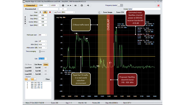
NextNav has petitioned the FCC to restructure parts of the lower 900 MHzband to host a terrestrial 5G/PNT network—essentially a ground-based GPS complement. The company’s plan would allocate parts of that band for high-power transmissions and relax the long-standing protections that keep low-power (Part 15) devices from destructive interference.
That same spectrum underpins hundreds of millions of existing systems: connected security sensors, toll-booth readers, smart meters, building automation networks, and the smart home products consumers rely on every day. These devices operate safely and efficiently because the FCC’s Part 15 rules limit interference and prohibit high-power operations in this shared public band.
Robust technical analysis, most recently the Pericle Communications study commissioned by the Security Industry Association, shows that high-power terrestrial PNT transmissions would block or degrade low-power communications up to 60 percent of the time. In plain terms, that means alarms that fail to trigger, silent sensors, and lost connectivity for devices that safeguard homes, businesses, and infrastructure.
Evidence indicates these devices could degrade significantly in performance, often to the point of un-usability. Once the band is reclassified, there’s no practical way to “retrofit” the millions of products already deployed. The result would be billions of dollars in stranded hardware, irrecoverable damage to company reputations, and a long, expensive replacement cycle for utilities, business owners, and consumers.
This isn’t an argument against terrestrial PNT. It’s an argument for evidence-based engineering.
— Avi Rosenthal
Multiple Paths to Resilient PNT
This isn’t an argument against terrestrial PNT. It’s an argument for evidence-based engineering. The Department of Transportation has identified several categories of GPS-complement technologies, including low-Earth orbit (LEO) satellite systems, time-over-fiber distribution, map matching/map tracking, and terrestrial RF. NextNav’s 900 MHz concept falls into the fourth category, but it’s only one of many.
The FCC recognized this when it opened its broad Notice of Inquiry in March 2025 instead of rushing into rulemaking. Other federally funded trials, such as the Broadcast Positioning System developed by NAB and UrsaNav’s eLoran solution, show that terrestrial PNT can be achieved without displacing unlicensed Part 15 devices.
Engineering redundancy into national infrastructure demands that we test multiple solutions in parallel, not gamble on a single proprietary approach that risks breaking what already works.
Coexistence Is the Standard, Not the Exception
Across every modern wireless domain — Wi-Fi, Bluetooth, Zigbee, Z-Wave, LoRa, Wi-SUN — coexistence testing is standard practice. Before a new technology enters a shared spectrum, it must demonstrate that it can live alongside incumbents. NextNav has not done that. Its coexistence claims rely primarily on simulations using optimistic assumptions about device density and duty cycle. Real-world deployments are far denser and far noisier.
Z-Wave and our industry partners simply ask for what every responsible engineer would: comprehensive, transparent field testing before the FCC alters the rules of a crowded band. That’s not obstructionism: it’s diligence.
Building Forward, Not Backward
Our message is simple: the U.S. needs PNT redundancy, but it must be built on coexistence, not displacement.
America’s connected infrastructure relies on the lower 900 MHz band precisely because it has been open, unlicensed, and reliable. Allowing a single licensee to flood that band with high-power signals would trade resilience for fragility.
Z-Wave Alliance stands ready to collaborate with the FCC, DOT, and all research participants to ensure the U.S. gets the GPS backup it deserves: one that strengthens, rather than undermines, the technologies that keep Americans safe, secure, and connected every day. To learn more, follow Z-Wave Alliance on LinkedIn and across social platforms: we are committed to keeping the U.S. technology community up-to-date on key proposal developments and opportunities to make their voices heard.
America’s dependence on GPS is a matter of national security, economic vitality, and daily life. We all agree: the United States must develop strong, resilient alternatives to satellite-based positioning, navigation and timing (PNT). The question, ironically enough, is how to get where we want to go.
Z-Wave Alliance, whose members build the smart home, security, and automation devices used in millions of homes and buildings, fully supports the federal effort to harden PNT infrastructure. We have been active contributors to the FCC’s Notice of Inquiry (WT 25-110) and the Department of Transportation’s Complementary PNT (CPNT) research program. We have provided and assessed technical data to help identify which terrestrial and space-based solutions can truly coexist with the technologies Americans already use every day.
A Known Risk
NextNav has petitioned the FCC to restructure parts of the lower 900 MHzband to host a terrestrial 5G/PNT network—essentially a ground-based GPS complement. The company’s plan would allocate parts of that band for high-power transmissions and relax the long-standing protections that keep low-power (Part 15) devices from destructive interference.
That same spectrum underpins hundreds of millions of existing systems: connected security sensors, toll-booth readers, smart meters, building automation networks, and the smart home products consumers rely on every day. These devices operate safely and efficiently because the FCC’s Part 15 rules limit interference and prohibit high-power operations in this shared public band.
Robust technical analysis, most recently the Pericle Communications study commissioned by the Security Industry Association, shows that high-power terrestrial PNT transmissions would block or degrade low-power communications up to 60 percent of the time. In plain terms, that means alarms that fail to trigger, silent sensors, and lost connectivity for devices that safeguard homes, businesses, and infrastructure.
Evidence indicates these devices could degrade significantly in performance, often to the point of un-usability. Once the band is reclassified, there’s no practical way to “retrofit” the millions of products already deployed. The result would be billions of dollars in stranded hardware, irrecoverable damage to company reputations, and a long, expensive replacement cycle for utilities, business owners, and consumers.
This isn’t an argument against terrestrial PNT. It’s an argument for evidence-based engineering.
— Avi Rosenthal
Multiple Paths to Resilient PNT
This isn’t an argument against terrestrial PNT. It’s an argument for evidence-based engineering. The Department of Transportation has identified several categories of GPS-complement technologies, including low-Earth orbit (LEO) satellite systems, time-over-fiber distribution, map matching/map tracking, and terrestrial RF. NextNav’s 900 MHz concept falls into the fourth category, but it’s only one of many.
The FCC recognized this when it opened its broad Notice of Inquiry in March 2025 instead of rushing into rulemaking. Other federally funded trials, such as the Broadcast Positioning System developed by NAB and UrsaNav’s eLoran solution, show that terrestrial PNT can be achieved without displacing unlicensed Part 15 devices.
Engineering redundancy into national infrastructure demands that we test multiple solutions in parallel, not gamble on a single proprietary approach that risks breaking what already works.
Coexistence Is the Standard, Not the Exception
Across every modern wireless domain — Wi-Fi, Bluetooth, Zigbee, Z-Wave, LoRa, Wi-SUN — coexistence testing is standard practice. Before a new technology enters a shared spectrum, it must demonstrate that it can live alongside incumbents. NextNav has not done that. Its coexistence claims rely primarily on simulations using optimistic assumptions about device density and duty cycle. Real-world deployments are far denser and far noisier.
Z-Wave and our industry partners simply ask for what every responsible engineer would: comprehensive, transparent field testing before the FCC alters the rules of a crowded band. That’s not obstructionism: it’s diligence.
Building Forward, Not Backward
Our message is simple: the U.S. needs PNT redundancy, but it must be built on coexistence, not displacement.
America’s connected infrastructure relies on the lower 900 MHz band precisely because it has been open, unlicensed, and reliable. Allowing a single licensee to flood that band with high-power signals would trade resilience for fragility.
Z-Wave Alliance stands ready to collaborate with the FCC, DOT, and all research participants to ensure the U.S. gets the GPS backup it deserves: one that strengthens, rather than undermines, the technologies that keep Americans safe, secure, and connected every day. To learn more, follow Z-Wave Alliance on LinkedIn and across social platforms: we are committed to keeping the U.S. technology community up-to-date on key proposal developments and opportunities to make their voices heard.
Safran Electronics & Defense‘s Skydel GNSS simulation platform is now fully certified to support simulation of Xona Space Systems’ low-Earth orbit positioning, navigation and timing (LEO-PNT) signal, Pulsar.
According to the companies, this certification is the culmination of a rigorous multi-phase validation program jointly led by Safran and Xona engineering teams. It underscores Safran’s commitment to advancing robust, high-fidelity testing for next-generation LEO-PNT services. With this milestone, engineers can now use Skydel to evaluate Pulsar’s performance in environments that reflect real-world complexity, interference and operational demands.
Skydel now simulates Xona’s Pulsar X1 signals, delivering centimeter-level precision, 100x signal strength and enhanced resilience — capabilities that Pulsar will soon bring to orbit.
“With Skydel-powered simulators certified for Pulsar X1, our customers have more possibilities than ever,” said Pierre-Marie Le Veel, program director of PNT simulation at Safran Electronics & Defense. “They can test LEO and legacy constellations side by side, introduce complex interference, and explore entirely new scenario combinations — all from a single, flexible platform. This is a major step forward in enabling engineers to push the boundaries of GNSS testing.”
Beyond accuracy, Skydel enables advanced resilience testing, including jamming, spoofing and other NAVWAR threats. Its modular, future-ready architecture ensures seamless integration of new Pulsar signal types and constellation updates, offering the agility needed to keep pace with the evolving LEO PNT landscape and demands for trusted, high-integrity PNT.
“Validation is the bridge between innovation and trust,” said Tyler Reid, CTO of Xona. “By replicating Pulsar at full fidelity, Skydel empowers engineers to design and validate solutions for the most demanding navigation and timing challenges — without waiting for on-orbit availability.”
Skydel’s certified Pulsar simulation capability is available now to partners and customers worldwide.
Xona has reached three new commercial agreements with precision timing innovators Hoptroff, Fibrolan and Timebeat, marking its official entry into the precision timekeeping and synchronization market. These partnerships seek to enable end users to leverage Xona’s Pulsar satellites to provide independent, secure, and resilient timing infrastructure amid mounting global complexity and risk.
Satellite navigation provides far more than positioning — it’s the world’s most accurate source of globally synchronized time signals underpinning nearly every critical system, including:
Emergency response coordination
Real-time power grid balancing
Transportation network resilience
Fair and trustworthy global financial trading
5G network synchronization
Data center efficiency and security
As infrastructure becomes more connected and distributed, timing is the backbone of data governance— determining who holds critical data, when it was held and for how long. A single second lost or spoofed can erode trust across every facet of daily life.
Broadcasting nanosecond-level accurate time from low-Earth orbit, Pulsar provides a new alternative to vulnerable GNSS-based systems. With built-in authentication, secure signals, and up to 100x received power of legacy GNSS, Pulsar ensures reliable reception even in low-rise buildings and urban environments — all without requiring specialized hardware, according to the company.
“This is an important milestone — proof that next-generation satellite technology is no longer just promising innovation, but solving real, urgent problems today.” said Jay Wakenshaw, COO of Xona. “Seeing market leaders like Hoptroff, Fibrolan, and TimeBeat adopt Pulsar validates that there’s a genuine need and significant demand for what we’re bringing to market.”
Pulsar testing and demonstrations in real-world environments will continue through this year and into early next year, with active field deployments planned from late 2026.
“Our customers in critical national infrastructure rely on precision timing to keep their operations secure, compliant, and efficient.” said Tim Richards, CEO of Hoptroff. “The low-Earth orbit Ssatellite system provided by Xona will add additional redundancy to our global timing network, and complements our existing terrestrial timing infrastructure which is essential for next gen applications particularly in these uncertain times.”
“We’re always seeking innovative alternatives to GNSS — because the future of timing depends on it.” said Shamir Stein, CEO of Fibrolan. “Pulsar is exactly the kind of breakthrough our industry needs: a powerful, dependable solution that will allow us to continue delivering simple, robust, and hassle-free timing to our partners and customers.”
New collaboration to demonstrate how terrestrial 5G-based timing can provide scalable solutions to complement and backup GPS.
NextNav and Oscilloquartz, a division of Adtran, have partnered to demonstrate how 5G-powered terrestrial positioning, navigation, and timing (PNT) technology combined with Oscilloquartz’s established synchronization systems can serve as a scalable complement and backup to GPS. The initiative aims to maintain the operation of critical infrastructure, such as data centers, utilities, and emergency services, during GPS outages by distributing precise, coordinated universal time (UTC) over existing 5G networks for both indoor and outdoor environments.
The collaboration integrates Oscilloquartz’s synchronization technology with NextNav’s terrestrial 5G PNT platforms to introduce an additional timing source, thereby reducing end-user dependence on GPS alone. This effort addresses increasing demand for secure and redundant timing solutions in light of threats to GPS reliability. The companies are aligning their technologies with ongoing Federal Communications Commission initiatives to encourage complementary PNT solutions.
According to the companies, this approach responds to national security and public safety concerns by prioritizing the development of resilient infrastructure. The demonstration of these integrated terrestrial timing capabilities is intended to provide a practical example of how industry can build more robust timing networks and reduce the risks associated with relying solely on GPS.
NAL Research, SGM Technology AS and Tschudi Shipping Company have formed a strategic collaboration to develop a new line of navigation and tracking products designed for the commercial shipping industry, using Iridium’s low-Earth orbit (LEO) satellite network.
This joint effort comes amid a rising need for reliable asset tracking and secure navigation tools in high-risk maritime regions, where threats to GNSS signals — such as jamming, spoofing and other forms of interference — are increasing on a global scale. Maritime authorities in some areas have reported a 350% increase in vessels affected by such disruptions in the past six months, according to NorthStandard. The technological interference has caused real-world consequences, including shipping collisions, operational delays, financial setbacks for global trade, and safety risks for crews at sea.
“As a fifth-generation shipping company, we’ve witnessed the evolution of maritime navigation, but never before have we faced technological threats such as GPS jamming and spoofing,” said Felix Tschudi, chairman of Tschudi Group. “These disruptions pose a serious risk to vessel safety, crew welfare, and the reliability of global trade routes. The industry must act collectively to address these vulnerabilities to protect maritime personnel and assets.”
The partnership’s initial focus is on integrating NAL Research’s decades-long expertise in assured positioning, navigation, and timing (APNT), tracking, and connectivity with the Iridium PNT service. This service provides a resilient, fully authenticated L-band signal engineered to withstand spoofing and jamming. The venture is also drawing upon SGM’s more than 15 years of experience in maritime technology and Tschudi Shipping Company’s international operations, bolstered by 140 years in commercial shipping and logistics. Together, their aim is to deliver high-reliability navigation solutions for environments where GNSS signals are compromised. Trials of the new solution are now underway.
“Protection against GPS vulnerabilities is no longer a nice-to-have, but a necessity to ensure operational success and asset safety,” said NAL Research President Robert Bills. “Through this collaborative effort, we are aiming to achieve complete global situational awareness and increase safety at sea for our commercial maritime customers, even in the most remote and challenging situations.”
“In today’s maritime landscape, the threat of GPS jamming and spoofing is no longer theoretical — it’s a growing reality. Ensuring navigational safety is critical, not just for protecting cargo and vessels, but for safeguarding the lives of seafarers who rely on precise and trustworthy systems every day,” said Steffen Grefsgård, CEO of SGM Technology AS.
Government, industry and public safety leaders call for action on PNT resiliency as threats escalate.
GPS is the invisible backbone of modern life, supporting America’s national and economic security in ways both recognized and overlooked. While other countries have developed competing systems, GPS remains far ahead of its rivals. Yet that dominance is also a vulnerability. GPS is a single point of failure, and the U.S. lacks complementary positioning, navigation and timing (PNT) solutions. A successful disruption could cost the U.S. economy $1.6 billion per day and impact everything from first responders to our energy grids.
As threats to GPS reliability mount, policymakers and industry leaders gathered on Capitol Hill to underscore the urgent need for backup systems to protect America’s PNT infrastructure.
Last month, I hosted an event on Capitol Hill called: “The Race to GPS Resiliency: What the US Can Do Today to Strengthen National Security.” It brought together senior officials from the Department of Defense (DOD), the Federal Communications Commission (FCC), Congress and industry to make the case for a layered approach to PNT resiliency. These experts examined the technical vulnerabilities of GPS, the increasing frequency of jamming and spoofing incidents, and the policy measures required to expedite the deployment of complementary technologies.
GPS: Foundational and Fragile
The first panel focused on how federal agencies are addressing growing vulnerabilities in GPS. Thomas Rondeau, Ph.D., principal director for FutureG at DOD, shared some eye-opening insights, including how a DARPA project demonstrated that, for less than $300 in parts from Amazon, one could “create a very bad day for the American military.” He called GPS disruption one of the easiest threats to develop and warned that adversaries are already exploiting this vulnerability as part of modern conflict.
From left to right: Diego Areas Munhoz, reporter, Punchbowl; Thomas Rondeau, Ph.D., principal director for FutureG, DOD; Arpan Sura, senior counsel, chief AI officer, FCC.
Rondeau shared how GPS disruption is now a feature of modern warfare, as he witnessed firsthand during his time at DARPA: “We were seeing massive loss of capabilities, and ordnance, because they were dependent on GPS. And as soon as they flew there, the tent turns on, capability goes away, we lose… assets.”
Arpan Sura, senior counsel and chief AI officer at the FCC, walked through the FCC’s process for evaluating GPS alternatives and discussed how the agency is considering complementary PNT technologies.
“National security is one of his (Chairman Carr’s) top priorities. And we recognize, as Tom mentioned, that GPS remains vulnerable to jamming and spoofing. But also, non-national security threats like solar flares, environmental risks like orbital debris. And there is heavy reliance on it in the U.S. economy,” Mr. Sura said.
Lives on the Line
From left to right: Mariam Sorond, board chair and CEO, NextNav; Adam Eldert, director of public safety for Fairfax County, Virginia.
During the second panel, the conversation shifted from global conflict zones to local communities. Adam Eldert, director of public safety for Fairfax County, Virginia, emphasized the life-saving value of resilient PNT technologies in emergency response.
“Technology should be carrying us forward, allowing us to make better decisions with the information we have to affect life-saving measures faster, get to places quicker and avoid any sort of potential problems,” said Eldert.
Mariam Sorond, CEO and president of NextNav, pointed out that GPS limitations can delay locating 911 callers and responding to active threats like a mass shooting situation she and Eldert had previously discussed. “It’s not just to save somebody’s life, but it’s also about preventing disasters.”
She then highlighted the company’s 5G-powered 3D terrestrial PNT solution, which is currently being considered by the FCC’s ongoing Notice of Inquiry on PNT and in a separate Petition for Rulemaking specific to NextNav. She explained that the company is working to address a national security challenge with a near-term, future-proof solution that delivers a widescale terrestrial PNT solution without relying on taxpayer funding.
Congressional Support
The closing panel featured Rep. Richard Hudson (R-NC), Chairman of the House Energy & Commerce Subcommittee on Communications and Technology, and former Rep. Greg Walden (R-OR), who previously chaired the full committee.
Both Hudson and Walden warned that the United States is lagging behind adversaries such as China and Russia in deploying terrestrial backup systems to GPS.
Chairman Hudson reflected on how the issue hits close to home: “I represent Fort Bragg, the largest army base in the world. We call it the epicenter of the universe. Our special forces and airborne troops that deploy out of Fort Bragg rely on GPS for almost everything they do. So, real-life scenarios with them keep me awake at night.”
Chairman Walden spoke about another high-profile case in San Diego. “[T]here was a naval exercise between two ships, and they jammed GPS… which caused some issues, ” said Walden. “It also speaks to the problem we have, in America, where, unlike China and Russia, two of our adversaries, they have terrestrial-based systems for GPS backup.”
What Comes Next
The event made clear that action is needed — and possible. Mr. Sura told the crowd that he believes the FCC’s Notice of Inquiry will help drive a conversation about a holistic approach to PNT resiliency, exploring the economics of how these systems will work, and how to foster competition in a way that will yield multiple outcomes. When asked about next steps, Mr. Sura encouraged the group to “stay tuned.”
Speakers throughout the event called for continued public-private collaboration to accelerate development of a more resilient PNT system — one that combines space-based and terrestrial technologies to safeguard national security, critical infrastructure, and public safety.
Congressman Hudson closed with a note of urgency and optimism: “It’s clear the FCC understands the urgency, and they’re conducting thorough reviews right now.”
Diane Rinaldo of Peake Advisors, which sponsored the event, is one of the country’s leading authorities on 5G, telecommunications supply chain security and privacy. She served as Acting Administrator of the National Telecommunications and Information Administration and Acting Assistant Secretary of Commerce for Communications and Information in the first Trump Administration.
Safran Electronics & Defense has introduced BlackNaute, a new autonomous positioning, navigation and timing (PNT) system. The system integrates Safran’s HRG Dual Core inertial navigation technology, the Skylight multi-mode GNSS receiver board and an atomic clock to offer navigation resilience in challenging electronic warfare environments.
BlackNaute’s built-in atomic clock is designed to maintain precise timing, which is essential for secure communications and collaborative combat operations. The system features advanced anti-jamming and anti-spoofing algorithms, which have been validated in more than 16,000 operational cases. These capabilities allow BlackNaute to detect compromised signals and automatically switch to autonomous and trusted navigation and timing sources to ensure continuity of operations.
Its modular design allows it to be adapted across a variety of platforms. Airbus Helicopters has selected the NH90 to be equipped with this new Embedded GNSS and Time INS (EGTI).
“What we are offering today is not just a new solution — it’s an operational guarantee, designed to meet the challenges of electromagnetic warfare,” said Alexandre Ziegler, Executive Vice President, Defense Global Business Unit at Safran Electronics & Defense. “It is a concentration of innovation combining precision, versatility, and security to ensure positioning, navigation and timing — anywhere, under any circumstances.”
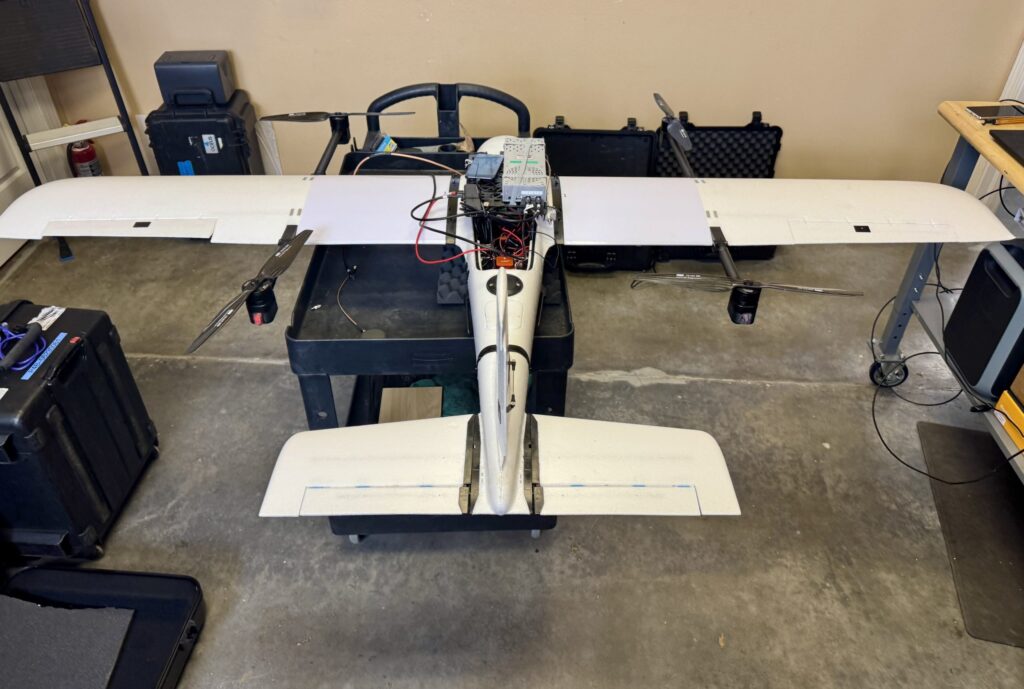
For the first time, the oneNav L5-direct receiver was flown on a UAV through a simulated electronic warfare GPS signal interference field. The assessment took place Feb. 12 at the Emerging Technology Lab at U.S. Special Operations Command (USSOCOM). This non-classified evaluation replicated battlefield conditions, including variable speeds, altitudes, maneuvers and robust L5 signal interference.
Assessment Setup
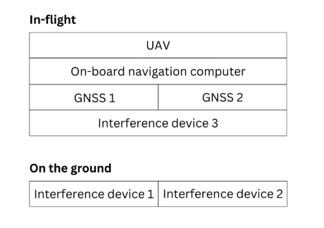
The assessment included two GNSS devices secured to the UAV, an onboard navigation computer and an onboard interference device. Two additional interference sources were located on the ground.
A simplified block diagram of the assessment setup. (Credit: oneNav)
The onboard navigation computer integrated data from both GNSS receivers to determine and maintain the vehicle’s position and guide its movement. GNSS 1 was a competitor L1/L5 dual-band receiver that uses the L1C/A signal for initial acquisition before adding L5 signals. GNSS 2 was the oneNav L5-direct receiver, which exclusively utilized modern L5-band signals for both acquisition and tracking.
Test Conditions and Results
The in-flight assessment, conducted on a UAV under real-world dynamic and RF interference conditions, demonstrated that the oneNav L5-direct receiver operates independently of legacy GNSS signals such as L1 and L2. While conventional dual-band receivers require L1 acquisition before transitioning to L5 tracking, the oneNav solution used only modern L5 signals for both functions6.
The Emerging Technology Lab implemented comprehensive RF interference protocols, including both ground-based and airborne signal interference across multiple L5 frequencies. The oneNav L5-direct receiver maintained tracking capabilities during L5/E5a signal interference centered at 1176.45 MHz. This performance is attributed to the receiver’s wideband RF front-end architecture, which enables simultaneous processing across an extensive frequency range. The system leverages Galileo’s dual sideband configuration (E5a and E5b), automatically transitioning to E5b when E5a experiences interference—a feature unique to the oneNav technology. A brief six-second delay was observed during this transition, reflecting a three-second lock loss on E5a followed by a three-second acquisition of E5b. The ability to track E5b signals, despite a 10 dB power differential, highlights the receiver’s sensitivity.
L5-direct FPGA attached to the assessment UAV. (Credit: oneNav)
Key Findings
The oneNav L5-direct GNSS receiver acquired, tracked and provided location data to the drone flight computer under actual flight dynamics and through L5 band signal interference.
Direct acquisition and tracking using only L5-band signals was demonstrated, confirming immunity to L1 signal interference.
The receiver demonstrated resilience to L5 in-band signal interference at typical electronic warfare power levels, quickly adapting by switching to the E5b sideband when E5a was disrupted.
The receiver maintained stability and responsiveness when both E5a and E5b sidebands were blocked.
Continuous tracking functioned well with the BeiDou constellation off and the almanac on or off6.
Technical Background
The oneNav L5-direct technology was originally developed for consumer applications such as wearables, phones and surface vehicles. Its adaptability allows for rapid customization and deployment across a range of platforms, including those requiring robust performance in challenging environments.
Because the L5-direct receiver uses signals exclusively within the L5 band, it can leverage the advanced features of these signals. L5-band signals offer greater power and increased resistance to RF interference compared to L1 signals. Industry experts, including Prof. Brad Parkinson, recognize the advantages of L5-only receivers for jam resistance.
Currently implemented on FPGA architecture, a future L5-direct ASIC is expected to deliver performance improvements, including enhanced acquisition and tracking capabilities.