Tag: construction

  • Trimble Offers Fleet Management App for Concrete Industry

    Trimble Offers Fleet Management App for Concrete Industry

    The TrimView fleet usage screen on an Android.
    The TrimView fleet usage screen on an Android.

    Trimble has introduced Trimble TrimView Direct, a mobile application that leverages existing real-time data collected by Trimble’s TrimFleet Suite for the ready-mix concrete industry. Trimble has teamed with development partner, BCMI, to expand on how the data is viewed and used by top-level management.

    The announcement was made at the World of Concrete.

    By leveraging mobile technology, organizations have access to instantaneous information so managers no longer need to wait for paper reports to understand the state of their business. Using TrimView Direct, ready-mix producers and management across the organization have real-time access to critical data that impact their daily business decisions. The app collects information from existing systems and integrates it in a Web-based environment to deliver an accurate view of the company’s strengths, customer trends and opportunities for improvement on a mobile platform.

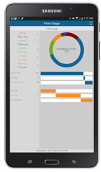
    The app, available on iOS and Android devices, provides a dashboard of real-time data, including order status, ticket details, order timelines, fleet analytics and performance, vehicle location, trip status, signal health, driver hours and performance. The data can be filtered and viewed using maps, graphs, charts and timelines for a visual representation of critical information.

    TrimView Direct is organized in modes: delivery, fleet and driver. Navigating using scrolling menus and toggle screens, users can tap or swipe the page to instantly find and record data.

    For example, managers use the fleet dashboard to see average cycle miles, current fleet usage, average costs, signal health and delivery performance for a fleet, plant, truck or group of trucks. Sales and account managers who are on a customer site can reference data in the field, including order status, performance, timeline and ticket information.

    “Our work with BCMI empowers today’s mobile worker,” said Glenn Bramer, director of marketing for Trimble Construction Logistics. “As we continue to develop solutions that transform the way work is done, we must look at how we can extend valuable information beyond desktop users and enable management to make smarter decisions anytime, anywhere. TrimView Direct is a bold step in this direction.”

    “Coupling Trimble’s expertise in collecting real-time data for improved productivity with our movement to modernize the tools and processes for ready mix operations, we have enabled the entire concrete production chain, both human and machine, to interact with actionable, real-time information,” said Bernie Benson, co-founder of BCMI.

  • Trimble Introduces ProjectSight for Cloud-Based Construction Management

    Trimble announced today Trimble ProjectSight, a cloud-based solution for construction field management that Trimble says simplifies the creation, access and sharing of project information between the field and the office. The new solution provides mobile workers with access to up-to-date project information and smart workflows for increased productivity and more informed decision making. Trimble ProjectSight allows contractors to lower software costs while enabling a wide team of collaborators to access the information they need.

    Trimble ProjectSight is designed for contractors and construction managers who want an easy-to-use and cost-effective field management application. Accessible via a web browser or an iPad app, ProjectSight features a simple, intuitive user interface overlaying smart, project-based workflows to keep teams in sync. Access to centralized data provides users with up-to-date information related to material tracking, issues reporting, information requests and critical project drawings, models and documents. Fully functional offline capabilities allow information to remain available during unconnected sessions commonly encountered on construction sites.

    ProjectSight joins other solutions in Trimble’s portfolio for managing construction project logistics, budgets, estimates, schedules, coordination and change in both 2D and 3D datasets. ProjectSight leverages the new Trimble Connect collaboration environment for design, engineering and construction firms. Trimble Connect enables teams to access and manage any data via a cloud platform and specifically allows ProjectSight users to access and share project management data with Trimble Connect users across the design-build-operate lifecycle.

    “Effective project management is critical to the profitability of any construction project,” said Mark Sawyer, general manager of the General Contractor / Construction Manager Division of Trimble Buildings. “With Trimble ProjectSight, we now offer a solution that addresses the core functions of project management in a very easy-to-learn, easy-to-use and easy-to-deploy system. ProjectSight ensures workers have access to accurate, up-to-date information and it puts that information in the hands of highly distributed teams at very low cost.”

  • Trimble Releases SketchUp 2015 for Intuitive Information Modeling Process

    Trimble V10 Export to SketchUp
    Trimble V10 Export to SketchUp.

    Trimble has released SketchUp 2015, the latest version of its 3D modeling software for architects, engineers, design and construction professionals. The release marks Trimble’s second update to the SketchUp software this year and underscores the company’s continued focus on enhancing the platform to make SketchUp faster, more user-friendly and reliable, Trimble said.

    The announcement was made at Trimble Dimensions.

    With a SketchUp user community expanding by more 30 million unique activations in the past year, enhancements to SketchUp 2015 have been designed to deepen and enrich the user experience, while keeping it intuitive. New features make it easier and faster to create, access, share and collaborate on 2D drawings and 3D models, Trimble said.

    SketchUp 2015 offers 64-bit support for Windows or Mac, while IFC file import capabilities allows back-and-forth sharing of IFC files between SketchUp Pro and any other application.

    “For the second release of SketchUp this year, we set out to make enhancements to the platform that might seem simple, but go a long way toward making SketchUp more enjoyable and impactful for our user community,” said John Bacus, director of SketchUp product management at Trimble. “For example, as interoperability continues to be the cornerstone of collaboration among architecture, engineering and construction professionals, the IFC file import is an important addition because it opens up the options for professionals to participate in the information modeling process, sharing files with ease, regardless of the software program.”

    Fast, Flexible and Powerful

    • 64-bit Support: In addition to continued support for 32-bit systems, SketchUp Pro 2015 is available in a 64-bit version for Windows and Mac. Trimble also now offers cross-platform support for all licenses, along with cloud-based license management and checkout capabilities for network licenses.
    • IFC Import: In addition to export, SketchUp Pro users can now share models between Building Information Modeling (BIM) tools and apply industry standard types that stay with the model as it travels with SketchUp 2015’s new IFC file import.
    • Ruby API and Extension Warehouse Enhancements: A variety of improvements to SketchUp’s Ruby API (application programming interface) and to the Extension Warehouse of SketchUp plug-ins and add-ons makes it easier than ever for developers to build and share great new tools. Developers can now access and modify information modeling classifications via the Ruby API.
    • Faster Core: Models render faster with core modeling performance improvements including faster explode, intersect and Fast Styles.

    More Easy-to-Use Tools

    • Professional Drafting: Using SketchUp’s LayOut 2D drawing and documentation tool, users can manage drawings more easily and display more data from their information models, applying object classifications in SketchUp and easily accessing that info in LayOut using an enhanced annotation tool.  
    • Modeling Tools: With the addition of a 3-point Arc tool, users can now draw arced edges four different ways. A new Rotated Rectangle tool allows for drawing precise rectangles unbound by default axes.
    • Expanded 3D Warehouse: New models of popular brand-name building products are added to 3D Warehouse every day, greatly expanding SketchUp’s free content offering. With over 2.5 million models, 3D Warehouse offers SketchUp users a vast array of free models to choose from. A new “Likes” feature lets users tell the world when they’ve found a great model.  

    SketchUp 2015 also facilitates collaboration with data and files from other Trimble products.

    • As a “Trimble Connected” product, SketchUp Pro 2015 leverages the new Trimble Connect collaboration environment for design, engineering and construction projects. Based on recently acquired Gehry Technologies’ GTeam™ software, Trimble Connect enables teams to access and manage project data via a cloud platform. A Trimble Connect extension is available in the Extension Warehouse.
    • SketchUp Pro 2015 also supports 3D CAD and BIM services for mechanical, electrical and plumbing (MEP) contractors through the new Trimble MEPdesigner for SketchUp platform, which enables contractors to quickly and easily migrate from a 2D to 3D work environment.  
    • Calibrated panoramic photos can be loaded directly into SketchUp 2015 from the Trimble V10 Imaging Rover to quickly model as-built conditions.

    Every SketchUp 2015 download starts with a 30-day trial of Pro features. Pro licenses can be used on a Mac or a PC.

  • Trimble’s Smart Water Software Adds GNSS Capabilities

    Trimble has introduced the latest version of its smart water infrastructure mapping and work management cloud software — Trimble Connect for Water version 1.9.

    The latest release of the geographic information system (GIS) centric software-as-a-service (SaaS) adds real-time, high-accuracy centimeter-level horizontal and vertical GNSS accuracy for capturing 3D asset positions. The new release includes a suite of applications that allow water, wastewater and stormwater utilities to accurately locate, inventory and visualize their infrastructure assets and increase operations and maintenance efficiency.

    The announcement was made at Trimble Dimensions.

    Trimble Connect for Water cloud software leverages Trimble’s GNSS rugged mobile devices and Esri’s GIS technologies to accurately map, locate and assess the condition of critical infrastructure assets, allowing utilities to keep their field infrastructure data up-to-date and accurate.

    The new release now supports Trimble’s Geo 7 Centimeter Edition rugged handheld, integrating 3D mapping into utility field workflows and enabling mobile workers to precisely locate and map the horizontal position and elevation of buried infrastructure.

    Trimble Connect for Water version 1.9 can be configured and deployed quickly on a variety of Trimble and non-Trimble mobile devices, laptops, tablets and smartphones, including Apple iPads, iPhones, Android, Windows and Windows Mobile devices to automate fieldwork and eliminate paper-based maps.

    Trimble Connect uses the latest Esri ArcGIS for Server, Mobile and ArcGIS Online basemap services. The software is designed to automate a variety of specific water, wastewater and stormwater industry workflows through individual pre-configured “apps” offered within the product and as part of a subscription.

    The new version provides standard core apps including Map Book, Manhole Inspector, Leak Repair, Hydrant Inspector, Valve Inspector, Meter Changeout, Incident Repair, Water Mapper, Wastewater Mapper and Stormwater Mapper. In addition, an optional partner app developed for American Flow Control (AFC) hydrant and valve data collection, “AFC Mapper,” can be purchased from AFC and their distributors for use with Trimble rugged handhelds.

    Trimble Connect for Water version 1.9:

    • Offers centimeter-level real-time GNSS accuracy to improve the quality and accuracy of the utility’s GIS data to precisely locate hard to find assets.
    • Allows capturing accurate vertical elevations in real-time. Combined with horizontal precision, the solution provides high-accuracy GIS data that can be used to measure pipeline slopes, perform flow analysis and generate 3D and hydraulic models.
    • Supports the Trimble Geo 7 Centimeter edition with an integrated laser rangefinder.
    • Offers pre-configured Water, Wastewater and Stormwater mapping apps, allowing utilities to quickly start mapping network infrastructure and updating their asset data.
    • Provides the capability to export data in a variety of formats including Esri File Geodatabase, Shapefiles and MS Excel, which allows users to update the utility’s enterprise GIS or visualize and analyze the collected data using third-party systems.

    Trimble Connect for Water version 1.9 is expected to be available in December 2014 from Trimble’s Water Division and its authorized distribution partners.

  • Juniper’s New Rugged Handheld Designed for Data-Collecting Efficiency

    The Allegro 2 by Juniper Systems. Photo: Juniper Systems
    The Allegro 2 by Juniper Systems. Photo: Juniper Systems

    Juniper Systems announced its newest rugged handheld computer, the Allegro 2, at the InterGeo 2014 trade show, held September 7-9 in Berlin. The handheld is the latest in the company’s Allegro product line, “with every bit of reliability,” the company says, but now with some major advancements.

    According to Juniper Systems, the Allegro 2 was designed for data-intensive applications, with meticulous attention paid to the engineering and design of the handheld to maximize efficiency and precision, both of which are critically important to high-volume data collection.

    Compared to the Allegro 1, the Allegro 2 has a newly designed keyboard in a QWERTY and numeric layout, with large, glove-friendly buttons for rapid — even non-visual — data entry. The new handheld features a custom Sun-to-Shade display that is 20 percent larger than the previous Allegro. It offers excellent visibility in any lighting conditions, the company said.

    The Allegro 2 is powered by an Overtime Technology battery, providing a 20+ hours of runtime. Its touchscreen uses capacitive technology, providing excellent durability, as well as crystal-clear imagery and greater sensitivity to touch, Juniper Systems said. The Allegro 2 has significantly enhanced GNSS performance, extended Bluetooth range, camera and video options, and a more powerful processor than the Allegro 1.

    “The Allegro 2 is our next-generation product, and it includes all of the latest enhancements available in its sister product, the Archer 2,” said John Florio, product manager at Juniper Systems. “The Allegro 2 was built from the ground up, based on user feedback on the jobs they have to do. Whether the customer is grading lumber in a log scaling yard, running a robotic total station, or performing a close-interval pipeline survey, the Allegro 2 is the best solution for the field today.”

    The Allegro 2 is scheduled to begin shipping in November.


  • Altus, Entegra Combine to Provide Tough Tablet with RTK Positioning

    The APS-GeoPod. Photo: Altus Positioning Systems
    The APS-GeoPod. Photo: Altus Positioning Systems

    Altus Positioning Systems, a Septentrio company, has integrated its APS-GeoPod product with Entegra Technologies’ Crossfire Pro Tablet. This collaboration, targeting the oil and gas, survey, GIS and transportation industries, provides a high-performance tablet-based solution for enabling ultra-precision RTK of sub-meter or centimeter accuracy.

    Altus is showcasing the APS-GeoPod and Crossfire Pro tablet, along with the full range of Altus products, at booth A1.060 and outside Booth FG.006 at InterGeo 2014 being held this week in Berlin, Germany.

    According to Altus CEO Neil Vancans, the Altus APS-GeoPod and the Entegra Crossfire Pro Tablet provide a combination of precision, performance and features that make it ideal for energy services, land surveys and other GIS-related applications.

    APS-GeoPod is a compact GPS/GLONASS RTK and DGNSS receiver that adds high-precision RTK positioning to USB-compatible tablet PCs. “This unique product gives users the convenience of adding RTK precision to any on-board application on mobile devices geared to the field service professional,” Vancans said.

    The Entegra Crossfire Pro tablet. Photo: Altus Positioning Systems
    The Entegra Crossfire Pro tablet. Photo: Altus Positioning Systems

    APS-GeoPod features include:

    • Compact dual-frequency GNSS module
    • Low power consumption (<1 Watt)
    • USB 2.0 interface
    • Internal L1 GPS/GLONASS antenna
    • NMEA integration with GIS software

    The Crossfire Pro tablet features the multi-touch interface and communication capabilities of smartphones, the large display and ergonomics of consumer tablets, and the daylight-readable screen and durability of rugged tablets. Safety features include UL 1604 Class I/Division II certification for operation in hazardous locations. To users, Crossfire Pro delivers a customizable tablet for exacting daily activities, resulting in greater efficiencies, response times, productivity and customer service levels, the companies said.

    Crossfire Pro tablet features include:

    • ADAPTIVE PERFORMANCE — Powerful, latest-generation processors, wireless communications, connectivity, and outdoor-viewable displays
    • ADAPTIVE EXPANSION — Standard and custom expansion modules — tailored to suit your workflow
    • ADAPTIVE CONNECTIVITY — Flexible user interactivity, including multi-touch displays (finger, glove and stylus), configurable I/O ports, clamshell keyboard and smart docking stations
    • ADAPTIVE RUGGEDIZATION — Variations in ruggedness to stand up to drop, shock, moisture, dust, temperature, and more.
  • Topcon Announces Geodetic Reference Receiver and Antenna

    Topcon's NET-G5 receiver and CR-G5-C antenna. Photo: Topcon
    Topcon’s NET-G5 receiver and CR-G5-C antenna. Photo: Topcon

    Topcon Positioning Group announces the next generation of its geodetic GNSS reference receivers and antennas — the NET-G5 receiver and CR-G5-C antenna.

    The announcement was made at InterGeo 2014, being held this week in Berlin.

    Using Vanguard and Universal Tracking technologies, the NET-G5 receiver incorporates 452 channels capable of tracking the full GNSS signal spectrum, including modernized GPS, GLONASS, Galileo, Beidou, QZSS and SBAS signals. Universal Tracking has the advantage and capability to assign any visible GNSS signal to any available receiver channel.

    The NET-G5 receiver is designed to work as a complete system connectivity solution, with built-in Bluetooth and Wi-Fi, for flexible wireless communications or via standard Ethernet, serial and USB connections. Other features include: High-precision code and carrier phase measurements up to 100 Hz; Power over Ethernet (PoE) and an all new Topcon receiver web interface with advanced receiver management features.

    “Comprehensive communication support, advanced web-server capability, and extended operating times are among the new features supported on the NET-G5. Coupled with the CR-G5-C antenna, the new systems provides a powerful, interference protected network solution,” said Charles Rihner, vice president of the Topcon GeoPositioning Group.

    “Whether you are installing an all-new GNSS network infrastructure, expanding or upgrading an existing network, looking for a premium campaign receiver or stand-alone RTK base station, the high-performance NET-G5 is designed to provide the most advanced reference station solution available in the market,” Rihner said.

    The CR-G5-C is a full-wave geodetic choke-ring antenna designed to address evolving requirements for reference networks and infrastructure monitoring applications. “The CR-G5 antenna has excellent vertical phase center stability over the entire GNSS frequency band, providing superior performance in tracking low elevation satellite signals,” Rihner said. “This new model employs cavity filter technology to more aggressively combat radio frequency interference in difficult environments.”

  • Live from InterGeo

    Brandenberg Gate InterGeo Photo: GPS World
    Photo: GPS World

    GPS World staff will be reporting from InterGeo October 7-9. The massive trade show, held this year in Berlin, is considered the world’s leading conference trade fair for geodesy, geoinformation and land management. With more than 16,000 visitors from 80 countries, it is one of the key platforms for industry dialogue.

    Staff members attending include GPS World Editor and Publisher Alan Cameron, Survey/GIS Editor Eric Gakstatter, and Digital Editor Joelle Harms. All three are accepting meeting invitations for companies interested in discussing their products and services. Contact [email protected].

    VIDEO PLAYLIST

    PHOTOS

    BLOGS

    InterGeo: The Worldwide GIS Showcase (09/25/14)

    NEWS

    Juniper’s New Rugged Handheld Designed for Data-Collecting Efficiency (10/10/14)

    Sokkia Announces Next-Generation Geodetic Reference Receiver (10/08/2014)

    Altus, Entegra Combine to Provide Tough Tablet with RTK Positioning (10/08/2014)

    Spectra Precision Launches Central Cloud Service, New Software Versions (10/08/2014)

    Topcon Announces Geodetic Reference Receiver and Antenna (10/08/2014)

    New Trimble Products Focus on Geospatial Imagery (10/08/2014)

    Topcon to Add 3D Mobile Mapping System to Product Lineup (10/08/2014)

    Sokkia Introduces NET AXII Measuring Station (10/07/2014)

    Topcon Announces Latest Addition to 3D Layout Line (10/07/2014)

    Trimble Offers Expanded GNSS Portfolio for Surveyors (10/07/2014)

    Trimble Offers Pipeline Construction Software for Oil and Gas (10/07/2014)

    Carlson Software Introduces Surveyor2 Data Collector at InterGeo (10/07/14)

    Carlson Launches GIS360 for Android at InterGeo (10/07/14)

    Hemisphere GNSS Offers New Survey-Grade GNSS Antennas (10/07/14)

    Applanix Offers Single-Board GNSS-Inertial System for UAV Mapping (10/07/14)

    Icaros to Unveil Versatile Nadir/Oblique Aerial Mapping System at InterGeo (10/03/14)

    InterGeo Event Considers Land Management Challenges (10/03/14)

    Trend- and Media-Forum at InterGeo Features Innovation, China (10/03/14)

    Juniper System, Soil Instruments Partner on Geotechnical Monitoring (10/03/14)

    Oxford Technical Solutions Launches Board Set for System Integrators (10/03/14)

    Orbit GT Showcases UAS Mapping Pro at InterGeo (10/03/14)

    Icaros to Demonstrate Measuring Tool for Oblique Imagery at InterGeo  (09/24/14)

    EUROGI Conference to Be Held in Conjunction with InterGeo (08/11/14)


    Join Us for Our Post-Show Webinar

    New Product Trends in UAV, Survey, Mapping, and Geospatial Data Collection and Analysis
    InterGeo Post-Show Report

    Thursday, October 16, 10 a.m. PDT/ 1 p.m. EDT / 5 p.m. GMT

    Summary: UAVs (unmanned aerial vehicles) are taking over the surveying industry, thanks to their ever-improving sensors and the fact that they are getting lighter and can therefore remain in the air for longer. They complete surveying and inspection tasks that would otherwise be difficult to tackle, and do so with impressive cost-efficiency. UAV trends and technology will be among the focal points at the InterGeo conference in Berlin in early October.

    Our correspondents will return with a fresh report, moderated by GPS World Editor and Publisher Alan Cameron and Survey Scene Editor Eric Gakstatter.

    Register for free!

  • Juniper Systems, Soil Instruments Partner on Geotechnical Monitoring

    Soil Instruments Limited has partnered with Juniper Systems Limited to provide a geotechnical monitoring system using rugged computers and geotechnical engineering instrumentation to improve field activities in the structural and earthworks industry.

    Pairing Juniper Systems’ Archer 2 rugged field computer with Soil Instruments’ Digital Inclinometer Systems provides field engineers with a robust measuring and data collection system, the companies said.

    Soil Instruments’ Digital Bluetooth Inclinometer Systems are now exclusively using Juniper Systems’ Archer 2 rugged computer, which provides superior readings and data capture, Soil Instruments said. Soil Instruments’ inclinometers are specially designed instruments that provide high accuracy and resolution measurement for the monitoring of structural and earth deformations, movements or settlement.

    “The rugged Archer 2 handheld computer pairs beautifully with Soil Instruments’ Digital Inclinometers, providing more accurate readings and data capture than could ever be achieved previously in this industry,” said Simon Bowe, general manager of Juniper Systems Limited.

    Juniper Systems’ Archer 2 rugged computer is connected to the inclinometer system via Bluetooth wireless technology. Within the borehole an angular reading is produced by the engineer via the Read button on the Archer 2 screen, which triggers the inclinometer sensors to take the reading.

    Those readings are then instantly transmitted via the Bluetooth connection to the Archer 2, captured on-screen and saved in the Archer 2’s database, to be reviewed for accuracy or other needed data measurements. Long days of field work remain productive because of the 512MB of RAM and 8GB of flash storage in the Archer 2.

    Data can also be transmitted back to base quickly and accurately via the 3.75G modem in the Archer 2, an action which many other inclinometers cannot complete. At the end of the day, data can be downloaded or transmitted for subsequent comparison against all previous borehole runs, allowing analysis of lateral ground movements over time.

    “Soil Instruments has found the perfect field computer to match with our Digital Inclinometer Systems”, said Mike Ziolek, sales and marketing director for Soil Instruments. “The Archer 2 really gives our customers an edge by providing field readings more quickly and clearly than any other inclinometer system.”

    The physical features of the Archer 2 and the Inclinometer Systems are highly compatible. The Archer 2’s IllumiView high-visibility display is extra large, incredibly bright, and overpowers glaring sunlight. The backlit LCD easily adjusts to either portrait or landscape orientation, and is glove-friendly and extremely scratch-resistant.

    The Archer 2 has ultra-rugged construction with IP68 protection against water and dust, and is shockproof against multiple drops. The intelligent Li-ion battery can operate up to 20 hours on one charge and is hot-swappable in the field. The high-sensitivity GPS/GLONASS/SBAS receiver is highly useful for field work.

    The ruggedness of the Archer 2 compliments the secure connections on Soil Instruments’ Inclinometer Systems. The inclinometer probes are mounted to a cable using an advanced waterproof moulding compound, which eliminates field connectors. This means that no on-site connectors get broken or contaminated while working in the field.

    Juniper Systems Limited will be demonstrating its superior, rugged handheld computers at InterGeo at Messe Berlin, Germany, October 7-9, in Hall 2.1 on Stand A2.039.

  • Handheld Group Launches Nautiz X8 Rugged Device

    Handheld Group Launches Nautiz X8 Rugged Device

    handheld-nautiz-x8-ultra-rugged-ip67-mapping-W Photo: Handheld Group
    Photo: Handheld Group

    Handheld Group, a manufacturer of rugged mobile computers, has launched the Nautiz X8 rugged PDA. The Nautiz X8 is a handheld computer with superior processing power, screen performance and battery life, the company said. It is built for tough field conditions primarily in GIS, land surveying, public safety, forestry and the military.

    handheld-nautiz-x8-ultra-rugged-military-rugged-W Photo: Handheld Group
    Photo: Handheld Group

    The Nautiz X8 is built to enable efficient and reliable data collection in tough environments. It has an IP67 ingress protection rating, which means it offers complete protection against dust and sand and can withstand immersion in water. It also meets stringent MIL-STD-810G military test standards for overall durability and resistance to humidity, shock, vibration, drops, salt and extreme temperatures.

    The Nautiz X8 features a high-performance Texas Instruments 4470 dual-core 1.5 GHz processor. It has 1 GB of RAM, 4 GB of iNAND Flash and a 5200 mAh Li-ion battery that lasts up to 12 hours on a single charge. It comes with a choice of operating systems — Android 4.2.2 or Windows Embedded Handheld 6.5.3.

    The device has a large 4.7-inch ultra-bright capacitive multi-touch screen with chemically strengthened Asahi Dragontrail glass, offering users brightness and protection in any field condition. The unit has an ergonomic design and weighs 490 grams (17.3 ounces).

    The Nautiz X8 has a dedicated u-blox GPS receiver, Bluetooth 2.0 and 802.11b/g/n WLAN functionality, as well as connectivity through GSM/UMTS or CDMA phone data transmission. A built-in 8-megapixel camera with autofocus and an LED flash lets users capture visual data quickly and easily. This handheld also features an open architecture and an extension cap system that allows for additional hardware connections such as sensors, radios and other add-ons.

    Orders for the new Nautiz X8 can be placed immediately. First deliveries will begin in November.

    The Nautiz X8 rugged handheld will be shown first at WEFTEC in New Orleans, followed by InterGeo in Berlin.

  • Septentrio, Altus Showcase High-Performance RTK at ION GNSS+

    Septentrio and Altus will be presenting their high-performance RTK systems at ION GNSS+ 2014. Attendees are invited to learn more at:

    • The Triple-frequency Multi-system RTK Engine for Challenging Environments (Session A1 room 18, Wed. 9/10 @11:48)
    • Gap Bridging in Precise Point Positioning (Session B6 room 19, Fri. 9/12 @3:20)

    High-performance RTK provides accurate positioning

    • in urban environments or under dense canopies
    • while suffering high ionosphere activities or
    • when coping with sparse networks
    • for maintaining a smooth transition during outages

    Plus, there is no baseline impact, even at greater than 40 kilometers. Visit booth 318/320 in the Exhibit Hall to learn more about the technology behind the performance.

  • Dual-Frequency Pinwheel Antenna Designed for Optimal Positioning 

    Dual-Frequency Pinwheel Antenna Designed for Optimal Positioning 

    The NovAtel GPS-702-GG-HV high-performance pinwheel antenna comes in three colors. Photo: NovAtel, Inc.
    The NovAtel GPS-702-GG-HV high-performance pinwheel antenna comes in three colors. Photo: NovAtel, Inc.

    NovAtel, Inc., has introduced the GPS-702-GG-HV to its line of high-performance Pinwheel antennas. Tracking L1/L2 GPS and L1/L2 GLONASS frequencies, customers can use the same antenna for GPS-only or dual constellation applications, reducing equipment costs and need for future redesign, the company said.

    With the same form-factor and choke ring performance as the company’s other pinwheel antennas, the GPS-702-GG-HV has been enhanced even further to provide the robustness needed for use under high-vibration conditions.

    The phase center of the antenna remains constant as the azimuth and elevation angle of the satellites change. Signal reception is unaffected by the rotation of the antenna or satellite elevation, so placement and installation of the antenna can be completed with ease. With the phase center in the same location for both the L1 and L2 signals and with minimal phase center variation between antennas, this antenna is designed for baselines of any length.

    Enclosed in a durable, waterproof housing, the GPS-702-GG-HV comes in three colors: NovAtel standard grey, as well as desert tan and olive drab for military customers. The antenna is available for order beginning September 12.