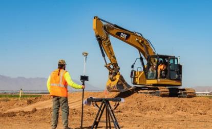
Hemisphere GNSS has released the GradeMetrix Scraper Solution for pull pan and belly pan scrapers on the construction site.
“We believe by introducing affordable GNSS technology to the construction industry’s bulk earth moving process, we provide a significant opportunity for equipment operators to increase their speed, accuracy and efficiency, resulting in substantial savings in fuel costs and equipment maintenance,” said Miles Ware, vice president of marketing.
“Hemisphere continues its commitment to bring high-performance, world-class 3D machine control and guidance solutions to the global market,” said Randy Noland, vice president of Global Sales & Business Development. “By adding the GradeMetrix Scraper Solution to our expanding product portfolio, we lower the barrier of entry and raise access to more markets and applications.”
GradeMetrix Scraper kits will be available for purchase for new customers. Existing customers will have the option to add scraper support to their current GradeMetrix system via a software upgrade and machine activation.
Hexagon AB, which offers digital-reality solutions combining sensor, software and autonomous technologies, will integrate AVVIR’s artificial-intelligence-powered technology stack into its portfolio of solutions that address challenges of the construction lifecycle.
Since 2017, AVVIR has enabled intelligent, data-driven job sites that empower commercial, infrastructure and industrial construction professionals to reliably and safely deliver on schedule and within budget, Hexagon stated in a press release.
AVVIR’s reality-analysis platform is focused on building information modeling (BIM). It is designed to improve project workflows, schedules and outcomes by leveraging onsite reality-capture data, enriched BIM models and artificial intelligence. The solution gives construction teams control with automated schedule tracking, cost and earned value analysis, installation issue detection, and an updated BIM with as-built conditions.
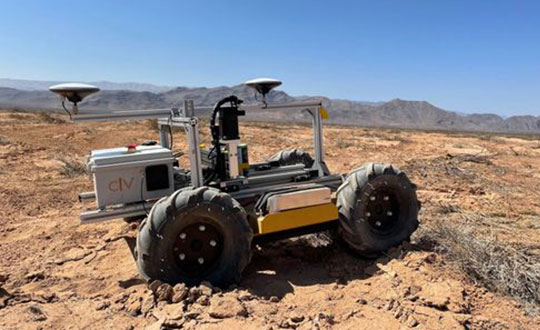
The CivDot UGV marks thousands of coordinates per day precisely and efficiently
Trimble Ventures, Trimble’s corporate venture capital fund, is investing in Civ Robotics, a San Francisco-based construction tech startup focusing on transforming surveying layout for civil engineering and infrastructure projects.
The investment supports Trimble Ventures’ mission to invest in early and growth-stage companies that are accelerating innovation, digital transformation and sustainability in the industries Trimble serves: agriculture, construction, geospatial and transportation. The investment terms were not disclosed.
The construction industry faces a variety of challenges including shortage of skilled workers, safety and productivity. Civ Robotics addresses these challenges with CivDot, a new autonomous surveying solution that empowers efficiency, productivity and safety on the job.
CivDot is an unmanned ground vehicle (UGV) designed for civil engineering and infrastructure projects such as solar farms, roadways, data centers, power plants and more. Augmenting the surveyor’s work, CivDot marks thousands of coordinates per day precisely and efficiently, while delivering layouts faster than traditional methods.
“We are focused on investing in companies that are seeking to address important challenges in markets that align with Trimble’s mission of transforming the way the world works,” said Aviad Almagor, vice president of technology innovation at Trimble and technology advisor for Trimble Ventures. “Civ Robotics technology supports surveyors and field workers and helps remove the burden of repetitive and risky work.”
Civ Robotics uses Trimble’s high-precision GNSS positioning technology and surveying software to improve productivity and increase safety, Almagor said. “This is an exciting opportunity to help accelerate innovation in autonomy, surveying and construction.”
“Trimble and our vision are in lockstep towards construction automation with a sharp focus on the highest standards of safety and quality,” said Tom Yeshurun, co-founder and CEO, Civ Robotics, which announced its $5 million seed funding round this morning. “Through Trimble’s latest GNSS technology in our autonomous surveying products, our customers can benefit from an end-to-end workflow.”
Civ Robotics will be showcased at the Trimble Dimensions+ User Conference, taking place Nov. 7-9 in Las Vegas.
The CivDot UGV, equipped with Trimble high-precision GNSS. (Photo: Civ Robotics)
Expanded Construction One Portfolio enables an end-to-end digital experience for heavy civil and infrastructure contractors to enhance productivity, profitability and sustainability
Trimble has acquired privately held B2W Software, a provider of estimating and operations solutions for the heavy civil construction industry. Financial terms were not disclosed.
With the passage of the U.S. Infrastructure Investment and Jobs Act (IIJA) and other infrastructure legislation across the globe, construction organizations are fast-tracking the digitization of their processes and operations. As infrastructure projects become increasingly complex, data-driven insights and analytics will be imperative to improve productivity, increase efficiency and drive sustainability.
“Seamlessly connected workflows are key to unlocking the true potential of an organization’s data,” said Elwyn McLachlan, vice president of Trimble’s Civil Solutions Division. “With the acquisition of B2W, Trimble will be able to provide an unparalleled end-to-end digital experience — connecting the digital to the physical — for heavy civil and infrastructure contractors.”
The addition of B2W’s comprehensive suite of pre-construction and operations capabilities will expand Trimble’s already extensive civil infrastructure portfolio and Trimble Construction One, a purpose-built connected construction management platform.
Photo: Trimble
B2W’s integrated suite of applications includes estimating, scheduling, field tracking, equipment maintenance, data capture and business intelligence. By combining these capabilities with Trimble’s field data, project management, finance and human capital management solutions, civil contractors will be able to bridge the gap between office and field in new ways, promoting transparency, efficiency and ultimately profitability.
“B2W has helped thousands of heavy civil contractors increase their bid accuracy and operational efficiency,” said Paul McKeon, B2W founder and CEO. “Now with Trimble, we can realize the next chapter of our story. By linking the planned with the executed, we will provide civil contractors with a truly connected construction experience, unlocking valuable new insights for our customers across their entire operation.”
B2W will be reported as part of the Buildings and Infrastructure segment.
Perkins Coie LLP acted as legal advisor to Trimble. Piper Sandler & Co. acted as a financial advisor and Foley Hoag LLP acted as legal advisor to B2W Software.
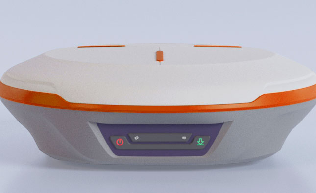
ComNav Technology Ltd. has released the N2 Palm RTK GNSS receiver. The release coincides with the company’s 10th anniversary. With its advanced technologies, the N2 is suitable for surveying, mapping and construction.
The N2 has a highly integrated main board and a three-in-one antenna, yet is extremely thin and portable, weighing about the same as a basketball (0.72 kg with battery) and measuring 48 mm, the thickness of AirPods.
Powered by ComNav’s SinoGNSS K8 high-precision module, the N2 can track 1,590 channels, including all existing and planned signals of GPS, BDS-2, BDS-3, GLONASS, Galileo, QZSS and SBAS. Its advanced satellite-tracking technology ensures it works well even in harsh environments, such as under heavy foliage or close to buildings.
A third-generation inertial measurement unit (IMU) makes the N2 immune to magnetic disturbance, which greatly improves its reliability. Pole-tilt compensation of up to 60° allows surveyors to locate difficult points precisely and easily while maintaining positioning accuracy within 2.5 cm. By using the company’s Quantum algorithm, the N2 achieves calibration-free operation — after 10 seconds of initialization, users can make tilt measurements with centimeter-level accuracy for an extended period, greatly improving efficiency.
With its integrated UHF modem, the N2 can reach a working range of up to 15 km. It can be used as either a base station or a rover.
The N2 features a 10,000 mAh intelligent Li-ion battery, along with ComNav’s patented low-power-consumption technology. It fully charges in five hours and works continuously in the field for 20 hours. The built-in USB-C port makes it convenient to charge with standard smartphone chargers or external power banks.
As with ComNav’s other products, the N2 meets ComNav’s high quality and durability standards; it is rated IP67 (dustproof and waterproof) and can work in temperatures from –35° C to +65° C. It can be used in a wider range of outdoor working conditions.
With near-field communication (NFC), the N2 can connect to other NFC-enabled devices, such as the R60 data collector. V5.0 dual-mode Bluetooth inside allows users to connect at ultra-long distances with low energy requirements.
The N2 Palm RTK GNSS receiver now is available through ComNav Technology authorized local distributors or directly from ComNav Technology.
Trimble has introduced data integrity monitoring for CenterPoint RTX Fast, its precise point positioning (PPP) correction service.
The Trimble RTX Integrity monitoring system is an innovative, patented solution, built in direct response to client requirements for production-ready applications. It continuously validates the reliability of correction data processed by the network, which is broadcast to users in the agriculture, geospatial, construction and automotive industries, ensuring positioning data is right the first time.
Through a two-step process, the Trimble RTX Integrity system verifies the integrity of GNSS data and filters faulty information in the network server before the data is broadcast. A secondary post-broadcast check is conducted on the entire data transmission process where additional errors may be detected and removed.
The integrity monitoring system is fully automated and reacts in seconds to detect, isolate and block faulty data to provide even more highly accurate and reliable positioning.
Trimble RTX Integrity is comprised of independent monitoring stations strategically positioned across RTX Fast networks in the United States, southern Canada and across Europe. These stations continuously monitor data output during multiple stages of the Trimble RTX positioning process. Any suspicious satellite data is removed during the integrity protection process and positioning is calculated using only validated data.
Trimble Alloy GNSS reference receivers power the independent monitoring stations using redundant internet connectivity for added reliability. To date, no other positioning network offers the same level of data integrity validation across such expansive, contiguous geographies.
Trimble RTX Integrity monitoring system was developed in accordance with Automotive Software Performance Improvement and Capability dEtermination (ASPICE) and ISO 26262 automotive safety standards, making it easy to integrate into major automotive manufacturers’ autonomous driving systems.
Trimble RTX Integrity can also be used by Trimble’s customers in the agriculture, geospatial and construction industries to ensure correction stream integrity and reliability for applications such as machine control and high-accuracy surveying applications.
“Trimble remains committed to exceeding expectations by providing accurate corrections to our customers to support safety-critical and other day-to-day applications,” said Patricia Boothe, SVP of autonomy, Trimble. “Implementing additional checks and balances to ensure our data is authenticated, trustworthy and accurate is of paramount importance to maintaining the integrity of our RTX network and instilling confidence with our users that the data is correct.”
Easily installed GNSS guidance kits offer access to design and payload data
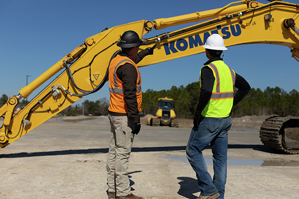
Heavy equipment maker Komatsu is offering Smart Construction Retrofit kits to enable affordable fleet upgrades. With the kits installed, conventional Komatsu excavators become “smart” with 3D guidance and payload monitoring.
Once a conventional excavator is retrofitted, operators no longer have to set up a laser or bench every time the machine moves. The kit’s GNSS receiver determines where a machine is on the job site and what the target grade is. The need for additional labor is reduced because the technology collects and delivers information directly to the operator, so fewer people have to be working on the ground or in an open trench.
Designed to improve grading performance and provide more time- and cost-management tools, Smart Construction Retrofit can bring 3D to most Komatsu excavators in a fleet. The entry-level solution can help bridge the technology gap. It gives operators the latest design data, measures payload volumes and load counts, and allows managers to monitor production from the office by integrating Smart Construction applications.
The payload meter helps prevent overloaded trucks by promoting proper loading weights for on- and off-road vehicles, to reduce the potential for equipment damage and other risks.
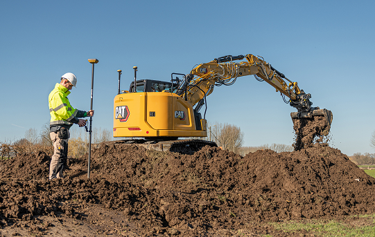
New GradeMetrix features include knuckle boom and swing boom support
Hemisphere GNSS has expanded the features of its GradeMetrix excavator solutions, adding support for knuckle boom and swing boom excavators as part of its GradeMetrix 3D Excavator solution.
The additional feature sets unlock enormous potential for GradeMetrix excavators, especially in the compact excavator market, according to Hemisphere. “Hemisphere recognizes that machine control technology for compact excavators has been an underserved audience globally,” said Miles Ware, vice president of marketing. “Based on direct feedback from our global machine control partners, and endless hours of testing, we are excited to introduce these options that will further enhance the available ROI [return on investment] for our customers.”
Photo: Hemisphere GNSS
“Hemisphere’s commitment to globally expand the access to machine-control technology continues to be a key component of our growth strategy,” said Farlin Halsey, president and CEO of Hemisphere GNSS. “Our strategy to combine best-in-class GNSS technology, with modern, efficient and intuitive features, further advances our efforts to make machine-control technology available to the global construction community, including such key customers as Iwasaki.”
“The opportunity to introduce a solution that supports excavators equipped with knuckle boom is a very important achievement for our organization,” said Satoshi Furuguchi, CEO of Iwasaki Co. Ltd. “Iwasaki and Hemisphere have a great partnership, and we look forward to empowering additional productivity solutions together.”
Hemisphere will make knuckle boom and swing boom options available in several of its new GradeMetrix excavator kits. Existing GradeMetrix excavator customers will have an option to add this feature to their current systems via an additional cable and sensor package available from an authorized GradeMetrix dealer.
Hemisphere GNSS is exhibiting at the Construction & Survey Productivity Improvement Expo in Chiba, Japan, at booth E-11.
Topcon Positioning Germany is one of 22 partners involved in CampusOS, a research project with the goal of developing a modular ecosystem for open 5G campus networks based on open radio technologies and interoperable network components.
As part of the German technology program “Campus networks based on 5G communication technologies,” innovative solutions for open 5G networks are being developed and tested in conjunction with the German Federal Ministry for Economic Affairs and Climate Protection. The program was launched at the beginning of 2022 and will run through 2025.
The use of artificial intelligence in the operation of autonomous plants and construction machinery requires the highest level of digital sovereignty. If Construction 4.0, including far-reaching automation, is to become a reality in Germany and the rest of the world, the processes of such data-driven solutions must run reliably, quickly and autonomously.
The German Federal Ministry for Economic Affairs and Climate Protection is providing €18.1 million in funding for the technology program over the next three years, which will cost €33 million total. The Fraunhofer Institutes FOKUS and HHI are coordinating the project. 22 partners from industry and research are involved, including Deutsche Telekom, Siemens, Robert Bosch and more.
“To enable companies to operate their own campus networks, certain requirements must be met; from standardized technology building blocks to network structures,” explained Ulrich Hermanski, chief marketing officer of the Topcon Positioning Group. “As the sole representative of the construction industry, Topcon will test the technologies on reference test sites and, therefore, will help shape the solutions for the future. We look forward to working with our research partners to take the digital construction site to the next level.”
With this research project, construction companies will one day be able to operate plants and machinery autonomously in open campus networks. This will allow the fluid and uninterrupted monitoring of construction sites in real time, as well as the networking of all sensors and construction machines in use on construction sites.
Autonomous from public networks, 5G technology guarantees seamless machine-to-machine communication and transmits data 10 times faster than 4G.
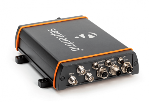
Septentrio has launched the AsteRx-U3 ruggedized GNSS receiver, successor to the AsteRx-U for construction, mining and other machine control applications.
The new receiver combines Septentrio’s latest triple-band precise positioning GNSS core with extended wireless communication features including Wi-Fi, UHF and 4G LTE. The versatile connectivity features of this receiver make it easy to fit it into any control system and enable simple and cost-effective overall design.
“We are excited to introduce AsteRx-U3 to the market of industrial automation,” said Silviu Taujan, product manager at Septentrio. “Its advanced connectivity package offers manufacturers and integrators access to reliable high-accuracy positioning in a system which is versatile, easy to use and easy to integrate.”
The AsteRx-U3 offers a unique feature, a guaranteed low latency of under 10 msec with a high data rate, which allows machines to work with rapid as well as accurate movements. An IP68-rated housing with fixing brackets and robust M12 connectors ensures a quick and reliable installation.
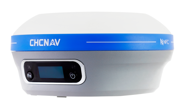
CHC Navigation (CHCNAV) has announced the availability of the i83 GNSS receiver, an addition to its premium GNSS receiver series for surveying, mapping and construction professionals. The i83 GNSS is powered by a 1408-channel multi-band GNSS receiver, the latest iStar technology, and a calibration-free, high-end inertial measurement unit (IMU) for faster and reliable field GNSS surveying.
“The i83 receiver combines GNSS and IMU into one single receiver to provide optimal automatic pole-tilt compensation that requires no calibration and is fully immune to magnetic interference. Operators just need to focus on their tasks and no longer need to level their pole vertically,” said Rachel Wang, product manager of CHC Navigation’s Surveying and Engineering Division. “In addition, we designed a high-resolution color display where users can clearly and intuitively get the GNSS receiver status to take full control of their survey operation.”
The third-generation high-gain antenna with the latest advanced CHCNAV iStar algorithm improves GNSS satellite signal tracking efficiency by more than 30%. The i83 GNSS receiver features 1,408 GNSS channels for high performance across GPS, GLONASS, BeiDou, Galileo and QZSS constellations. Its onboard GNSS technology delivers centimeter-level positioning, maintains reliable fixed real-time kinematic (RTK) accuracy, and collects points faster than previous models, even in demanding conditions.
Automatic compensation for pole tilt
The i83 receiver’s built-in IMU automatically compensates for pole tilt, increasing surveying, engineering and mapping efficiency by 30% over conventional GNSS RTK surveying methods. In less than 5 seconds, the 200-Hz inertial module is initialized to ensure survey-grade accuracy over a pole tilt range of up to 30 degrees. Productivity is dramatically increased, RTK usability greatly improved, and potential human error reduced, whether you are an engineer, site foreman or surveyor.
Integrated Wi-Fi, Bluetooth and near-field communication (NFC) modules provide seamless connection to field data controllers or tablets. Integrated 4G and UHF modems enable any GNSS survey mode, from RTK network NTRIP connections to UHF base-rover configurations. GNSS RTK corrections can be accessed or broadcast continuously for accurate positioning in all circumstances.
Users do not need to carry backup or external batteries in the field because of the i83 GNSS’ ultra-low-power system-on-chip (SoC) electronic design and smart power management. The i83 GNSS can operate for up to 18 hours as a GNSS RTK network rover or more than 8 hours as an RTK base station.
The i83 GNSS receiver is available worldwide through the CHCNAV distribution network.
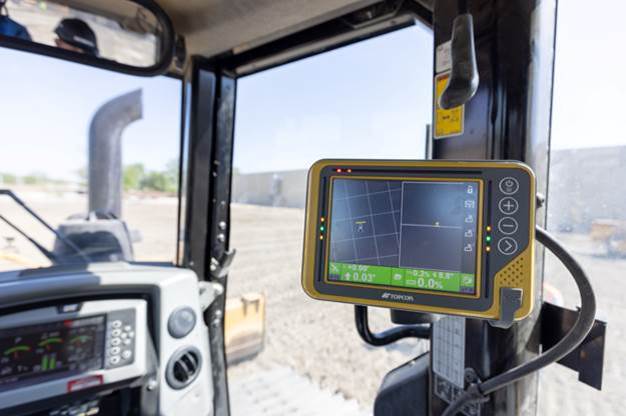
Topcon Positioning Group has announced its MC-Max machine control solution. Based on its MC-X machine control platform, and backed by Sitelink3D — the company’s real-time, cloud-based data management ecosystem — MC-Max is a scalable solution for mixed-fleet heavy equipment environments. It is designed to adapt to owners’ machine control and data integration needs as their fleets and workflows expand.
MC-Max increases processing power, speed, accuracy, versatility and reliability; and can be installed on a full range of dozers and excavators, using the same basic modular components. Modern, redesigned user and product interfaces were developed based on real-world applications and customer feedback and provide a simplified and immersive user experience that allows operators to learn the system easily.
“With MC-Max, we’ve created a solution that is flexible and can continue to grow as a contractor’s needs and capabilities expand,” said Jamie Williamson, executive vice president, Topcon Positioning Group. “This new solution provides improved scalability and precision in the field and offers business owners real-time data integration, connectivity and resource management capabilities across their entire workflow.”
The MC-Max solution offers flexible mounting solutions, as well as optional automatic blade and bucket control for a variety of machines. The system also provides a full battery of positioning technologies ranging from slope control to laser, multi-constellation GNSS, robotic total station and millimeter GPS systems.
MC-Max provides project managers a real-time view of machine positions, activities and onsite progress, and is compatible with a wide range of site communications systems.
Topcon MC-X Platform
The Topcon MC-X Platform is designed to make machine control easy to use and affordable for all contractors. The platform ties together mixed fleets by interacting with multiple versions of 3D-MC, providing connectivity to Sitelink3D and taking advantage of the multi-constellation capabilities of GNSS antennas.