Tag: construction

  • ComNav Technology: Proving high-tech is not a last resort

    ComNav Technology: Proving high-tech is not a last resort

    ComNav’s high-accuracy PileMaster sped construction of the Aarah Resort in the Maldives. Photo: LANKA Foundation and Piling Services Pvt. Ltd.
    ComNav’s high-accuracy PileMaster sped construction of the Aarah Resort in the Maldives. Photo: LANKA Foundation and Piling Services Pvt. Ltd.

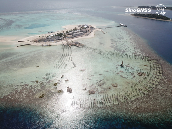
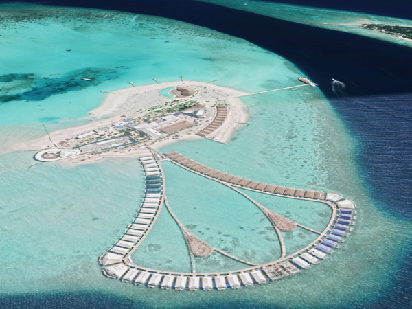
    The construction of the Aarah Resort in the Maldives involved building 64 luxury water villas and 12 beach buildings on a shallow-water area with about 1,400 piles. LANKA Foundation and Piling Services Pvt. Ltd. was able to complete the piling project in only 32 days by using a high-accuracy piling solution from ComNav Technology Ltd.

    The traditional piling approach requires many surveyors to stake out the positions of the piles underwater in advance. Not only is this process labor-intensive, it also creates a real-time problem: even if the coordinates are measured accurately by lofting, the primary coordinate markers are soon out of position due to the movement of the piling machines. The stakeout’s accuracy is also threatened by strong waves, ocean currents and coral reefs. Furthermore, in the subsequent piling process, the piling accuracy is reduced due to artificial aiming. During the whole process, surveyors must work in the water and fix the piles at short range, which is dangerous. For these reasons, the traditional piling approach is a low-efficiency, high-cost and high-risk operation.

    Photo: Google Earth
    Photo: Google Earth

    ComNav’s professional positioning solution for high-accuracy piling provides a 9-inch high-resolution tablet with an integrated GNSS receiver, a T300 GNSS receiver as the base station, and two AT340 antennas with magnetic mounts combined with PileMaster software. Its integrated GNSS receiver tracks GPS, GLONASS and BeiDou signals, enabling the system to work even in challenging environments. The system can acquire real-time kinematic (RTK) corrections via an internal UHF transceiver from the T300 receiver or connect to a local continuously operating reference station (CORS). Moreover, PileMaster is designed with an intuitive interface with clear element-management capability, supporting import of up to 10,000 points from Excel, TXT and CAD formats to meet the specific demands of a high-accuracy piling project.

    Compared to the traditional piling method, ComNav’s intelligent control system for piling is an all-weather, high-accuracy solution with the additional advantages of being widely compatible and easy to manage. Through software system control and real-time processing and display, it can greatly reduce the number of surveyors required on-site. The system can guide users to the location, shorten the construction period, save construction costs, and enable intelligent visualization and monitoring to ensure high-precision construction work.

    After a first successful application in 2017, Foresight Surveyors Pvt. Ltd, ComNav’s local partner in the Maldives, used the solution in many projects, including construction of the Kunaavashi Resort & Spa in 2018 and the Kuda Villingili, Dhigufaru Island and Maniya Faru resorts in 2019.

  • Leica AP20 AutoPole provides tilt-compensation for surveyors

    Leica AP20 AutoPole provides tilt-compensation for surveyors

    Photo: Leica Geosystems
    Photo: Leica Geosystems

    Leica Geosystems, part of Hexagon, has introduced the Leica AP20 AutoPole — a solution for automated total stations that boosts productivity with tilt compensation, automatic pole-height readings and unique target identification.

    The AP20 AutoPole combines an intelligent sensor module with the new AP Reflector Pole and operates with Leica Geosystems’ existing automated total stations to create a solution for autonomous workflows.

    It is designed to solve three workflow challenges:

    • holding the pole vertical and stable
    • entering the pole height manually into the field software
    • locking to a foreign target on a site with multiple reflectors.

    The tilt compensation of the AP20 AutoPole increases efficiency when working with total stations. It is no longer necessary to level the pole for measurements and stakeout. Tilt compensation decreases measurement time and increases flexibility and safety on site by enabling the measuring of points in locations that are inaccessible or put the user at risk. By updating the pole height automatically in the field software, the system ensures that the height on record is always correct, which avoids errors, time-consuming postprocessing and returning to the field to remeasure.

    Additionally, the AP20 AutoPole’s target identification ensures the user’s instrument will always lock to the correct target.

    “At Leica Geosystems, we understand that tight time schedules, growing expectations for accurate on-demand data and budget constraints put a lot of pressure on surveyors and construction professionals,” said Hans-Martin Zogg, business director, Total Stations, Leica Geosystems. “The AP20 AutoPole is a game changer because it solves several challenges simultaneously. Its tilt compensation and automatic pole height readings are absolutely unique in the industry and will transform how professionals measure with total stations.“

    “As a surveying company, the only way we can stay competitive and profitable is to acquire spatial data simply, quickly and efficiently,” said Clifton Webb, director of Warner Surveys. “The Leica AP20 helps us stay ahead of the curve by increasing our productivity and flexibility. It allows us to measure points that were impractical or unsafe to measure before.”

  • JAVAD GNSS: A Surveyor’s Perspective

    JAVAD GNSS: A Surveyor’s Perspective

    Shawn billingS, RPLS, reinvests some of his profits in surveying gear, like this JAVAD GNSS unit. (Photo: Rebecca Billings)
    Shawn Billings, RPLS, reinvests some of his profits in surveying gear, like this JAVAD GNSS unit. (Photo: Rebecca Billings)

    By Shawn Billings  
    RPLS, Proprietor, Pendulum Surveying and Dealer

    The AEC industry relies on surveyors to be a bridge between the existing landscape and the design landscape. Surveyors have been providing virtual reality for centuries, albeit in a mostly analog way, until very recently.

    Imagine that a school board needs a new school. It describes the need to an architectural or civil engineering company, which develops a conceptualized plan. Next, it is time to figure out how to adapt this rough concept to the real world. Will the school fit within the boundaries of its district’s property? How will it access public rights-of-way? Can the current roads accommodate the traffic it will bring? How will the school access utilities? How will the building impact existing stormwater drainage? How do various data collected by others (such as geotechnical and wetlands delineation) fit into the site plan?

    The data collected by the surveyor inform the designer, usually in the form of a map — historically on paper, but now in digital form. Most designers want the key features extracted rather than a dense point cloud, so it is important for surveyors to be able to understand what those key features are.

    AEC surveying differs from boundary surveying in several ways. First, it usually requires consideration of a 3D world, not only two dimensions. Secondly, it will usually involve many thousands of points, not a few tens of points as is usually the case in boundary surveying. Third, AEC surveying will typically involve many more stakeholders. Fourth, the liability in AEC surveying will usually (but not always) be greater because of the significant costs involved.

    AEC surveying can be challenging because the timeframes are typically tight, with numerous professionals involved. Surveyors will often have to wait on others one day, only to be rushed the next day once the ball moves into their court. However, the tools available to us today allow us to collect data much more quickly than we ever could before.

    Today, I can carry almost everything I need to survey in a compact car—my Javad GNSS real-time kinematic (RTK) system, my robotic total station, my handheld electronic distance measuring device, my laptop computer, my smartphone (which provides internet access), my digital camera, my lidar and my photogrammetric drone, as well as the accessories needed for each device. All these devices have become more portable, more powerful, and less expensive. The gains in efficiency have reduced fieldwork by more than half over the past couple of decades, requiring fewer people and generally providing much better quality data.

    Today, it is rare for a surveyor to provide paper deliverables to designers. Almost all prefer digital files, usually vector data in DWG or DGN format along with surfaces in XML format.

    Recently, I have worked on several small commercial building projects. The requirements were the same for each. The initial survey includes (among other things):

    • a title boundary survey
    • the location of existing utilities and structures
    • contours at one-foot intervals
    • the delineation of the floodplain, if present on the site
    • the location of streets and other public access.
    • Once the initial survey is complete, I often set control for machine control, which heavy machinery uses to perform grading without requiring stakes. Once grading is complete, I often stake out building locations and sometimes paving.

    Challenges have included working with city planners who do not always have the same sense of urgency as the project developers and designers.

    Perhaps the greatest lesson I have learned is the importance of being efficient without being in a hurry, which breeds mistakes, such as missing important details or breaching a safety protocol and causing a serious injury.

    I also have learned that while technology can increase profits, it is important to reinvest some of them into improving my work product. This way, I enjoy a better return on my investment, but I also enjoy a better deliverable for my clients.

  • How precise point positioning became a survey crew favorite

    How precise point positioning became a survey crew favorite

    A positioning service energizes large pipeline surveying projects, saves time, and becomes a field crew favorite

    For projects spanning large areas, a large engineering and construction firm discovered that a precise point positioning (PPP) service — Trimble’s CenterPoint RTX — could solve the challenge of receiving high-precision GNSS in remote areas.

    Atwell Group LLC is a national consulting, engineering and construction services firm with 33 offices throughout the country and more than 1,000 team members. The company delivers a broad range of strategic and creative solutions to clients in three core markets: oil and gas, power and energy, and real estate and land development.

    Atwell provides comprehensive turnkey services, including land and right-of-way support, engineering, land surveying, environmental compliance and permitting, and project and program management.

    Photo: Trimble
    Photo: Trimble

    Pipeline construction

    Atwell’s introduction to PPP and Trimble’s CenterPoint RTX took place during two large-scale linear pipeline projects within remote areas. Atwell has substantial experience with projects of this scale, but the remoteness of some of the projects’ sections was proving to be a challenge. While they could expect to rely on base or network correction methods for most projects, Atwell needed to seek other correction alternatives — and up their efficiency for the long-corridor projects.

    With the CenterPoint RTX service at hand, Atwell performed construction staking and as-built surveys for a 50-mile pipeline. The project spanned a five-month period, with an hour or more of time saved each day using the service.

    Crews noticed an additional benefit: rapid response time. On any given day, there could be project managers, right-of-way agents, or inspectors on site, asking for additional survey data.

    “Inspectors and others started to notice how fast our crews could jump from one place to another and get the shots they requested, without having to do any base setups,” said Jason Jung, project manager with Atwell.


    “The speed at which our crews can get up and running with RTX is awesome.” — Jason Jung, 3D laser scanning projects manager, Atwell


    Because of the range limits of base radios, the crews might have to do multiple setups of a conventional real-time kinematic (RTK) base each day. RTX removed this hindrance, saving the crews time by not having to use temporary RTK bases, which entails driving to base reference points, setup and teardown, and downtime from malfunctioning equipment and battery issues.

    “RTX completely freed us from the time and hassle of base setups,” Jung said. “You turn it on, and it’s ready to go before you’ve had time to take a sip of coffee. And once our crews got used to it and gained confidence in the results, they have really loved this solution.”

    Photo: Trimble
    Photo: Trimble

    Scanning a pipeline

    Atwell recently used CenterPoint RTX on a 135-mile large-diameter pipeline project that included 19 facilities along the route. Atwell provided as-built services related to the facilities using a Trimble X7 scanner.

    The data captured was used to generate spatially correct site models that included the material traceability necessary to comply with Pipeline and Hazardous Materials Safety Administration (PHMSA) regulations. Crews used RTX to georeference point clouds from the scanner to provide the accuracy needed to comply with industry regulations. Each site was referenced with permanent monuments or scribes that tied into the master control system.

    Crews also used the RTX service to establish hard checkpoints to meet Atwell’s strenuous quality-control requirements for ground targets, such as those used in UAS control work. To do the daily “in and out” check shots, they used the free BenchMap app to locate nearby survey control marks from the National Geodetic Survey database. Most checks were sub-0.08’.

    The time saved in not having to change base positions, as well as setup and breakdown, were significant time savers along this lengthy project. The precisely registered scans helped speed up PHMSA required inspections and audits, and construction change management field operations.

    A crew favorite

    Atwell’s crews use Trimble R10 receivers and Trimble Access running on TSC7 controllers, but Jung noted that they have recently upgraded to some R12i GNSS receivers, “and they are already earning their keep.” He expects to realize even more benefits from RTX coupled with the advanced multi-constellation capabilities of the Trimble ProPoint RTK engine in the R12i.

    RTX has not only become a crew favorite, it is fast becoming a go-to solution for many Atwell projects.

  • Komatsu adds Smart Construction Drone and Field to line-up

    Komatsu adds Smart Construction Drone and Field to line-up

    Image: Komatsu
    Image: Komatsu

    Heavy-equipment maker Komatsu has added two new “smart” products to its job-site solutions for construction contractors, Smart Construction Field and Smart Construction Drone.

    Smart Construction Field

    Komatsu has partnered with Moovila, an experienced provider of project management software, to develop Smart Construction Field, a mobile app that allows contractors to easily record job site activity and analyze operational efficiencies in near real time.

    Reports generated by Smart Construction Field can track daily job-site conditions. Task progress can be broken down by labor, equipment and materials, including machine utilization and fuel distribution, receipts, timecards and subcontractor work. Regardless of equipment brand, Smart Construction Field can collect machine data from an entire fleet.

    Smart Construction Drone

    Smart Construction Drone survey technology collects accurate topography, including quantities for production tracking and billing, without personnel walking the job site to do a manual survey.

    Contractors can gather and analyze data throughout each project phase with topographic surveys that incorporate hundreds of thousands of data points. With the capability to take still photos from up to 400 feet above ground level or under bridge decks, Smart Construction Drone can be used as pre-job verification or to keep stakeholders up to date.

    Smart Construction Drone is designed to work with Smart Construction Dashboard. Built to combine data from multiple sources into one comprehensive picture, Smart Construction Dashboard combines 3D design data with aerial mapping and intelligent machine data, allowing contractors to confirm quantities and visualize job-site progress.

    Smart Construction Dashboard is powered by the 3D visualization power and geospatial accuracy of Cesium, a platform that visualizes, analyzes and shares 3D data.

    Both Smart Construction Drone and Smart Construction Field are part of Komatsu’s Smart Construction solutions, an umbrella of smart applications created to help construction customers optimize their business remotely, and in near-real time.

    “When the Smart Construction group came in, they integrated everything, and the transition felt seamless,” said Kevin Hawkinson, vice president of operations, A.W. Oakes & Son. “Now, we can take the data, transfer it to the machines, get data back from the machines to the office, and utilize all of that information across the board for bidding, customer reference and billing.”

  • Percepto launches drone with advanced AI analytics

    Percepto launches drone with advanced AI analytics

    Percepto Air Mobile drone with base. (Photo: Percepto)
    Percepto Air Mobile drone with base. (Photo: Percepto)

    Percepto, an Israel-based company specializing in autonomous inspection with industrial robotics, has launched its 2022 Autonomous Inspection & Monitoring (AIM) platform and Air Mobile drone.

    Recently listed in TIME magazine’s 100 Best Inventions of 2021, Percepto offers an end-to-end solution powered by artificial intelligence (AI) to collate and streamline all visual data for accurate actionable insights.

    Percepto AIM 2022 has a new Insight Manager to deliver AI-powered packaged solutions for sector-specific use cases, such as solar, mining, energy, oil and gas and other industries. The company drew on tens of thousands of hours collected by autonomous robot missions at industrial facilities to create it.

    Percepto’s AI change-detection framework offers unified visual data and critical business insights for each of the sector-specific solutions. AIM 2022 can be integrated with autonomous drones and robots as well as other visual data collectors, now including DJI drones, and fixed cameras.

    Reports and insights are automatically generated based on the combined visual data. Disseminated to relevant stakeholders on any mobile device, issues and faults are geotagged and displayed on a map, enabling effective action before escalating into more serious problems.

    Percepto also introduced its new Percepto Air portfolio to support the enhanced platform, which will address the diverse needs and increasing demands of various markets.

    Percepto Air Max. The next generation of Percepto Sparrow, the Percepto Air Max is a field-proven solution that operates in the largest mining, oil and gas, and energy companies on six continents. It has a top-grade, versatile payload for specific use cases. Designed to inspect and map complex industrial environments where the highest accuracy and durability are critical, Air Max also has an optical gas imaging (OGI) camera.

    Percepto Air Mobile. This option is a more compact and lighter weight model for smaller sites or organizations taking their first steps with a drone-in-the-box program, or larger sites that need greater deployment flexibility. It is designed for linear inspections, such as pipelines and power lines, and can monitor short-term projects across multiple sites, such as construction sites.

    Percepto Air Max and Air Mobile drones are stored permanently onsite within their respective Percepto Bases. The Air Mobile’s base is light and easy to relocate while maintaining high levels of durability. These encasements are designed for infrequent maintenance and protection against extreme environmental phenomena, such as hurricanes. Percepto’s drones are safe and regulation ready, and ensure all operational aspects meet corporate standards.

    “Percepto AIM 2022 and the new Percepto Air line of drones, together with the most advanced change detection solution, alert and prevent failures and downtime within diverse use cases across many industries,” said Percepto CEO Dor Abuhasira. “Percepto AIM provides the most advanced and comprehensive enterprise inspection software that offers a complete data workflow — from capture to insight. With Percepto Air Max and Percepto Air Mobile, companies have a range of options to choose from depending on the size of their facilities and the flexibility needed to deploy drones.”

    “The real power of Percepto’s system is how data collection and analytics are integrated for a holistic view from both a technical and management perspective,” said Tim Shanfelt, director of Operations Transformation, Koch Ag & Energy. “Our workers are connected to high-level information that helps them make the right decisions while keeping them safe and free to pursue higher value activities. Our goal is to eliminate hazardous, wasteful, and mundane tasks from our operators’ day. For example, instead of an employee climbing an icy ladder in the winter, a robot or drone can perform the same task while still obtaining accurate measurements. We see Percepto playing a significant role in helping make our facilities more safe, secure, efficient, and profitable.”

  • Trimble and Microsoft partner on industry cloud for construction

    Trimble and Microsoft partner on industry cloud for construction

    Companies to develop an industry cloud to enable construction organizations to harness digital construction data across the project lifecycle

    Trimble and Microsoft have entered a strategic partnership to advance technology adoption and accelerate the digital transformation of the construction, agriculture and transportation industries.

    By leveraging the Microsoft cloud, Trimble and Microsoft will collaborate to develop, build and deliver industry cloud platforms and solutions that connect people, technology, tasks, data, processes and industry lifecycles. The collaboration represents a significant milestone to advance Trimble’s Connect and Scale 2025 strategy, which centers on building cloud platforms.

    Initially, Trimble and Microsoft will focus on building the Trimble Construction Cloud powered by Microsoft Azure.

    Image: Trimble
    Image: Trimble

    The construction process is fragmented, which can result in lost productivity, rework and a lack of transparency. According to a McKinsey & Company article*, the construction industry is lagging with only 1 percent productivity growth over the last 20 years — significantly lower than the 2.8 percent for the total economy.

    Digitization of products and processes is expected to drive change in the industry. The ability to link technologies, tasks, processes and multiple stakeholders — general contractors, subcontractors, designers, engineers and owners — across the construction project workflow can transform and significantly improve productivity, quality, safety, transparency and sustainability, according to Trimble.

    The partnership expands Trimble and Microsoft’s existing relationship to combine the Microsoft cloud with Trimble’s construction solutions and industry domain knowledge. Trimble’s construction solutions include on-machine and field technology, modeling and collaboration software, project and resource management, and all underlying analytics.

    The Trimble Construction Cloud, expected in 2022, will be fully enabled for 3D constructible models that will reduce risks, drive speed and increase efficiency and accuracy across the construction project lifecycle, including designing, building and operations.

    The companies will also partner on go-to-market strategies and solutions to enable continued support of infrastructure investment cycles, and be used for large-scale projects, on which multiple stakeholders work in parallel to deliver connected construction projects.


    * McKinsey & Company
    The next normal in construction: How disruption is reshaping the world’s largest ecosystem

  • The hazards of mixing RTK bases

    The hazards of mixing RTK bases

    Single-base RTK is an excellent choice for many uses but mixing different baseline lengths can yield inconsistent results

    By Gavin Schrock, PLS

    Gavin Schrock, PLS
    Gavin Schrock, PLS

    The surveying lead for a construction firm started getting calls from his crews — suddenly they were not checking in to existing control with the accuracy required. This presented a conundrum and an immediate resolution was needed to stay on schedule. What had changed? A nearby permanent base, part of the regional real-time GNSS network (RTN), had suddenly gone dark, and when the crews switched to other bases, they got the inconsistent results. Time to call the RTN. (See a primer on RTN.)

    I have been operating a regional cooperative RTN for 19 years, and I get these kinds of support calls regularly, but typically only from users of the single-base mountpoints. Most RTN provide, via NTRIP casters, both network RTK (NRTK) solutions — such as master-auxiliary, VRS and FKP — and single-base solutions for each base. The base they had been using was down while the roof of the city building on which it is mounted was undergoing some maintenance.

    The construction firm, halfway through a multi-year transportation project, had used the base when they established project control, and for layout and as-built tasks. Using the base, which was slightly more than 4 km from the site, the crews were used to seeing check-in results of 0.3′ (9 mm) or better (horizontal). When they switched to different bases, 23 km and 25 km distant, the results were now inconsistent, and in many instances, double.

    This was an easy fix. We met on site and checked results using the network solution; it closely matched the results they were seeing from the original base. Until the original base was restored, this would meet their needs.

    It made a lot of sense to use the nearby base, as setting a temporary project base on the congested and sky-view challenged site was impractical. Furthermore, the baseline length of 4 km yields excellent results. Single-base RTK is a powerful tool, and a default for many construction projects, provided that:

    • the base has an unobstructed view of the sky
    • the base is free of nearby multi-path hazards
    • the base receiver and the antenna are of the same or better quality as the rovers
    • the base receiver and the antenna support the constellations and the signals desired.

    In many ways, it is hard to beat single-base RTK. For instance, if you set up a base right on the site, say less than a kilometer away, this should yield the best results possible for RTK, and can be better than network RTK.

    However, there are challenges. Single-base, typically “iono-free” solutions common in today’s rovers, degrades over the baseline length. The rule of thumb for many is that the degradation becomes noticeable when baseline lengths exceed 10 km. It is not uncommon for rovers to fix at much longer baseline lengths; 20 km, 30 km, 50 km or more — but results will likely vary from hour to hour or day to day. Changes in ionospheric and tropospheric conditions can bring inconsistencies, particularly over longer baseline lengths.

    Network RTK may not beat single-base over very short baselines, but as it uses 5 to 15 bases (depending on the implementation) it can better model in the varied conditions. It can provide great consistency and repeatability, even if an individual base is unavailable, as was the case for this conduction site. There are strengths and weaknesses for both. NRTK brings consistency over a wide area, you do not have to set up (and guard) your own base, and the geodetic values are solved.

    If you can have an on-site base, you can under certain conditions see a gain in results. This is especially important for certain applications, such as machine control and precision agriculture, for which tight year-to-year and row-to-row repeatability is key. However, if you may need to use another base at some point, you may be better off starting with NRTK, if it yields the results you seek.


    Gavin Schrock is a practicing surveyor, technology writer, editor of xyHt Magazine and operator of a cooperative GNSS network.

  • Hexagon acquires Jovix material tracking company

    Hexagon acquires Jovix material tracking company

    Photo: Jovix
    Photo: Jovix

    Hexagon AB, a global leader in digital reality solutions, has acquired the Jovix software and services business from Atlas RFID Solutions LLC of Birmingham, Alabama.

    Jovix is a material tracking software developed specifically for the construction industry, providing project decision-makers with real-time, actionable data regarding material status and location.

    The cloud-based and mobile configurable workflow platform offers visibility and traceability into the status and location of materials throughout the engineering, procurement and construction (EPC) lifecycle. This streamlined process, coined “material readiness” by Jovix, ensures construction crews have required materials without delay to complete their work according to plan. This is achieved by fully digitizing the supply chain to provide real-time, geo-contextual, and relational visibility from fabrication to installation.

    Jovix combines web-based server software with information from multiple types of sensor tags and readers to automate previously manual, paper-based data-collection workflows about the status and location of material as it moves throughout the construction supply chain.

    The software has been deployed in 25 countries on more than 650 job sites, including multibillion-dollar oil and gas and chemical construction projects. There are more than 7,500 Jovix users worldwide.

    “The acquisition supports our continued expansion into the procurement, fabrication, and construction market,” said Hexagon President and CEO Ola Rollén. “By removing impediments to productivity that result from material management issues intending to reduce material wait times to zero, Jovix provides value for owner-operators, EPC firms, contractors, fabricators, and suppliers.”

    Jovix will be fully consolidated as of Oct. 1, operating within Hexagon’s Project Portfolio Management division. The acquisition has no significant impact on Hexagon’s earnings.

  • Topnet Live GNSS network expands to meet digitalization demands

    Topnet Live GNSS network expands to meet digitalization demands

    Topnet Live has increased types of correction services and subscription options. (Image: Topcon)
    Topnet Live has increased types of correction services and subscription options. (Image: Topcon)

    Topcon Positioning Group has expanded its Topnet Live GNSS network of correction solutions to support today’s work environments. The global network now has more types of correction services and subscription options.

    This growth is a result of the increasing demand for digitalization in various industries including construction, surveying, machine control, and agriculture.

    The flexible service options include Realpoint, the real-time kinematic (RTK) service, and Starpoint, a precise point positioning (PPP) service. The different services have varying delivery methods, coverage and reliable centimeter-level accuracy. Under a flexible subscription model, customers can purchase to suit their needs.

    Additionally, Skybridge — an RTK service supported by PPP — is available to maintain connectivity and productivity if the customer temporarily leaves RTK coverage.

    “The Topnet Live RTK network, first established over a decade ago, continues to grow with 5,100 reference stations globally, a 14% increase in the last year,” said Ian Stilgoe, Topcon vice president. “We are growing throughout the world in areas where there is an increasing demand for productivity and accuracy through digitalization, with strong growth particularly in North America and Europe. We are focused on continued expansion to maximize support for our customers, so they always have the best options globally.”

    Original equipment manufacturers (OEMs) supplying automotive, industrial Internet of Things (IoT), autonomous robotics and all sectors that require positioning, navigation and guidance also benefit from the enhanced robustness of the network. OEMs can sell their hardware with correction services onboard and preconfigured for immediate use by customers, regardless of geographic location, with flexible subscription and licensing options to suit the exact need.

    Topnet Live uses all four GNSS constellations: GPS, GLONASS, Galileo and BeiDou. The customer benefits from continuous accuracy and always-on service coverage. This service provides these distinct advantages in the industries it supports:

    • Survey, construction and machine control. Topnet Live removes the need for individual base stations, dramatically increasing flexibility, productivity and safety and can drive large-scale projects with constant, reliable accuracy.
    • Precision agriculture. The solution delivers fast, consistent, accurate positioning at any time day or night for soil preparation, seeding, spreading, spraying and harvesting.
    • OEMs, system integrators, product designers. The solution provides scalable precise positioning and supports the implementation of flexible business models tailored to fit both OEMs’ and their customers’ needs.
  • Hexagon expands AR capabilities with Immersal acquisition

    Hexagon expands AR capabilities with Immersal acquisition

    Hexagon AB has acquired Immersal Oy, an innovator of spatial mapping and visual positioning solutions for producing augmented reality (AR) applications.

    AR applications enhance real-world experiences by augmenting a user’s visual perception with the display of digital content in the physical world.

    AR’s ability to weave context-specific, 3D information into physical spaces provides endless opportunities to save time, improve performance and reduce costs across a wide range of industries and applications — from surveying, construction, public safety and manufacturing to maintenance, training and navigation applications.

    An immersive experience can help boost task efficiency, improve safety protocols, optimize workflows and increase collaboration.

    The Immersal SDK (software development kit) allows developers to merge and “anchor” digital content to real-world objects – with precise accuracy to their actual location in the physical space — by enabling a user’s mobile device to locate and orient itself in the surrounding physical world using machine-readable maps.

    The maps, which are used for visual positioning, are constructed from image data supported by various mapping devices (including mobile phones) and hosted in the Immersal Cloud Service.

    “Hexagon has long been a leader in delivering smart digital realities that combine inputs from reality capture sensors with advanced visualisation software and tools to enable remote, location-based intelligence. This acquisition puts the power of these insights into the hands of those on-site, enhancing their field of view with superimposed digital information, meaning they can literally do more with what they see,” said Hexagon President and CEO Ola Rollén. “For example, direct access to information about an asset — while working with that asset — including step-by-step instructions on how to repair it, can streamline maintenance tasks while reducing material waste and re-work.”

    Immersal has years of experience developing AI and machine learning-based spatial anchor technology, which “anchors” virtual objects or models for viewing on different devices in the same position and orientation. This unlocks a wide variety of location-based solutions and services — from consumer-oriented augmented reality applications in gaming and media and entertainment to digital twin solutions on an enterprise scale.

    Immersal’s technology can map large spaces — both indoors and outdoors — and works both offline on-device and online using the Cloud Service.

    Founded in 2015 and headquartered in Helsinki, Finland, Immersal will operate as part of Hexagon’s Geosystems division. The acquisition has no significant impact on Hexagon’s earnings.

    Image: Hexagon
    Image: Hexagon
  • Charting Hong Kong’s nooks and crannies

    Charting Hong Kong’s nooks and crannies

    Photo: Yongyuan Dai/iStock/Getty Images Plus/Getty Images
    Photo: Yongyuan Dai/iStock/Getty Images Plus/Getty Images

    Team Provides Accurate 3D Maps for Smart City Applications

    The PolyU team's mobile mapping backpack. (Image: The Hong Kong Polytechnic University)
    The PolyU team’s mobile mapping backpack. (Image: The Hong Kong Polytechnic University)

    According to 2019 statistics, more than 10,000 residential buildings in Hong Kong are at least 50 years old. Most of these buildings lack 3D indoor building information models (BIM), which creates challenges when it comes to reconstruction or maintenance.

    In response, a team at Hong Kong Polytechnic University (PolyU) has developed a lightweight and reliable 3D mobile mapping system in a backpack. The system can easily measure cities and obtain 3D maps with centimeter-level accuracy. It can be used to build spatial data infrastructure, which supports smart city applications in many fields.

    The system uses advanced technologies such as simultaneous localization and mapping (SLAM), useful in urban canyons where GNSS signals can be spotty. It can carry out continuous data collection in complex indoor and outdoor environments, and is particularly suitable for high-density and complex urban environments, such as those in Hong Kong.

    The mapper is providing a special boon to modular integrated construction (MIC) in the city. With MIC, free-standing integrated modules are prefabricated and then transported to the site for installation in a building. However, the trucks hauling the large components can’t always maneuver through narrow streets in Hong Kong’s urban areas.

    One of many narrow streets mapped in downtown Hong Kong. (Image: The Hong Kong Polytechnic University
    One of many narrow streets mapped in downtown Hong Kong. (Image: The Hong Kong Polytechnic University

    To address the issue, the PolyU team collaborated with the Hong Kong Construction Industry Council, providing its mobile-mapping backpack to conduct 3D measurement of critical road sections. The project identified and mapped obstacles, and optimized the route for transporting oversized components to avoid narrow passages.

    Mobile-mapping backpacks also can be used to create detailed indoor 3D models to support firefighting and provide evacuation routes for personnel at the fire scene.

    The route taken by the mobile mapping backpack carrier in the harbor area. (Image: The Hong Kong Polytechnic University)
    The route taken by the mobile mapping backpack carrier in the harbor area. (Image: The Hong Kong Polytechnic University)
    A sample point cloud from the mobile mapper. (Image: The Hong Kong Polytechnic University)
    A sample point cloud from the mobile mapper. (Image: The Hong Kong Polytechnic University)

    The mobile mapper is one of the technologies developed by PolyU’s Smart Cities Research Institute, established in 2020 to help address social issues and provide solutions for smart city development. In March, the institute’s projects received a gold medal at 2021 Inventions Geneva Evaluation Days.