GNSS, coupled with inertial systems and software, is enabling greater accuracy in construction and agriculture. Other markets using machine control include unmanned vehicles, mining, surveying, mapping and defense.
At construction sites, GNSS receivers can be found in heavy equipment such as bulldozers, excavators, graders and pavers. On farms and in orchards, GNSS increases productivity of machines ranging from tractors to UAVs.
A new MarketsandMarkets report predicts the machine control system market will grow to $6.6 billion by 2024, a compound annual growth rate (CAGR) of 8.16%.
For precision agriculture, the outlook is even brighter. Grand View Research anticipates the market will reach $12.9 billion by 2027, a CAGR of 13% over the period.
Machine control speeds projects and increases efficiency under tight timelines. Using GNSS to guide the heavy lifting also alleviates safety concerns related to workers and construction machinery, and provides situational awareness to field operators.
In this month’s feature, we share case studies from companies that specialize in these markets, provide product details, and review the status of real-time kinematic (RTK) GNSS in agriculture.
Check out some use cases for how GNSS, inertial systems and software are enabling greater accuracy in construction and agriculture.
When completed, the underwater auto and rail tunnel will connect Germany and Denmark. (Image: Femern A/S)
A European megaproject is relying on GNSS to guide supportive earthworks during construction. The Fehmarn Belt Fixed Link is a planned underwater tunnel that would allow travelers to go by car or train between Germany and Denmark in only seven to 10 minutes. Once completed, the 18-kilometer-long tunnel will be the world’s largest of its kind and is expected to employ up to 3,000 people.
The 7 billion Euro project is expected to be completed in nine years. Danish construction company Holbøll A/S is building earthworks for 56 bridges on the main route crossing Denmark to where the tunnel would start. Holbøll’s undertakings include ramps and drainage work for the new bridges.
Holbøll has 130 employees and a machine park of 22 machines equipped with machine control from Leica Geosystems, enabling it to deliver innovative and sustainable solutions on time and at the agreed price.
At one of the bridges in Vordingborg, operator Flemming Ove Nielsen uses a Leica iCON GD4 3D system on the 61PX Komatsu dozer to perform the first rough work for building the slopes. Using the the iCON GPS 80 receiver, the iCON grade iGG4 system ensures fast and reliable grading with GNSS. Nielsen uses machine control to create the slope, and then the excavator takes over for the final grading work.
Image: Femern A/S
“The dozer is very efficient for this sort of work because it can move so much dirt and, with machine control, hold the correct angle of the blade,” explained Carl-Ole Holbøll, co-owner and managing director of Holbøll. The dual GNSS solution for the dozer is an advantage because the slope is so steep, and to achieve an accurate cross-slope, dual GNSS is required.
On another bridge, an excavator is using the Leica iCON iXE3 3D system for the finishing layer of the ramp slope. The operator can document the height of the different dirt layers simply by placing the bucket and letting the iXE3 register the height. This saves time — the operator doesn’t have to wait for a surveyor to conduct as-built documentation for each layer.
The Fehmarn Belt Fixed Link prime contractor, Femern A/S, has taken the next steps to develop the area where the factory for the tunnel elements will be built. Continued archaeological surveys, preparatory supply infrastructure and drainage has been financed at 55 million Euros.
Geared with Leica Geosystems, Holbøll A/S has prequalified for several of the derived projects, including the draining and moving of eight hectares in Strandholm Lake in Denmark.
Topcon Positioning Group released a new strategy through its Topcon Solutions Store retail channel. Together with Autodesk, and as an Autodesk Platinum Tier Partner, the Topcon Solutions Stores retail channel plans to expand top-tier service to civil-construction and BIM professionals through acquiring and adopting automation into its workflows.
The plan calls for a shift from traditional retail “box moving” sales approach, to a complete solution offering that combines hardware, software, and services. In order to deliver best-in-class service, training, and support, the plan includes renovation for 11 Topcon Solutions Store facilities in preparation to obtain their Autodesk Authorized Training Center (ATC) designation — joining two more store locations that are already approved Autodesk Training Centers.
The Autodesk Platinum Tier partner designation indicates the highest level of reseller status, and will allow TSS to continue to grow with significant investment in training, consulting and development services.
Mark Contino, Topcon VP, North American Retail Distribution, said, “By combining Topcon’s precision measuring and positioning hardware with Autodesk’s world-class software portfolio, the Topcon Solutions Stores seamlessly provide complete end-to-end workflows that greatly improve productivity and efficiency. Soon, all 13 locations across the U.S. will be repositioned to deliver the highest level of training, support, and workflow consulting services in the civil construction and BIM space. Not only will Topcon Solutions Stores be able to help customers analyze operations, every location will also help all the way through implementation and on-going support with local, professional training programs.
“The renovation of our facilities across the U.S. is part of our dedication to offer the modern solutions centers that the industry demands to provide this service,” Contino said.
Kirk C. Givens, senior manager, Autodesk Americas Channel Sales, said, “Topcon’s strategy to deliver a complete end-to-end solution in the civil-construction and BIM space is exciting. It’s truly game changing to be able to deliver a complete workflow combining two world class solutions – Autodesk software and Topcon hardware. Supporting that through 13 brick-and-mortar locations with professional training and support facilities will provide tremendous value to customers in the construction market.”
Trimble, Hilti and Boston Dynamics are collaborating to explore the integration of Trimble’s and Hilti’s construction-management software solutions, GNSS technology and reality-capture devices with Boston Dynamics’ Spot Robot platform.
Autonomous robots can play a significant role in construction, specifically in production and quality control workflows by enabling automation of routine and tedious tasks, reducing workload and improving safety. The companies will collaborate to develop a “proof-of-concept” solution.
Equipped with Trimble’s and Hilti’s reality capture devices as its payload and directly communicating with a cloud-based construction management application, the Boston Dynamics Spot Robot will be able to provide consistent output, deliver improved efficiency on repeatable tasks and enable up-to-date as-built data analysis.
The autonomous, terrain-agnostic capabilities support the dynamic nature of the construction environment, enabling the robot to bypass obstacles and maintain its defined path to support routine tasks such as daily site scans, progress monitoring, asset management and remote support.
Multi-directional communication between the robot, Trimble’s and Hilti’s payloads and the cloud application support a continuous flow of information and closes the loop for the construction environment.
“Utilizing robots for routine tasks in hazardous environments to improve safety, efficiency, and data capture consistency is part of our digital transformation vision” said Aviad Almagor, senior director for Mixed Reality and Brain-Computer Interface (BCI) at Trimble. “We are excited for this latest collaboration and looking forward to the potential integration of our hardware and software solutions with the Boston Dynamics’ Spot Robot to enhance field-oriented workflows, reduce amount of rework and facilitate on-site tasks.”
“Trimble’s and Hilti’s domain knowledge, market leadership and technologies are a great fit for our robotic platform,” said Michael Perry, vice president of Business Development at Boston Dynamics. “Deploying an integrated solution in the real-world environment doing dirty and dangerous work, before, during and after the construction stage is a common vision for the three companies, which can help drive the transformation of the construction industry.”
Bentley is a global provider of comprehensive software and digital twin cloud services for advancing the design, construction, and operations of infrastructure, and Topcon is a leader in positioning technology for the survey and construction industries.
The companies made the announcement at The Year in Infrastructure Conference, held Oct. 21 in Singapore.
Digital Construction Works has a global staff of digital construction experts and provides digital automation, integration and “twinning” services around a portfolio of fit-for-purpose software and cloud services from Topcon, Bentley, and other software vendors. The venture was created to realize the “breakthrough potential of constructioneering” for industrializing construction, according to a press release.
Bentley Systems and Topcon joined forces in 2016 to jointly develop enhanced integration between their respective MAGNET and ProjectWise cloud services so that engineering and construction workflows could be integrated for improved project quality and performance.
Since then, Bentley and Topcon have continuously introduced innovations in surveying, reality modeling, scheduling and logistics, work packaging, machine control, and progressive assurance for construction.
In 2017, they opened Constructioneering Academies, including at Topcon’s “sandbox” facilities, for construction professionals to experience new digital best practices, first-hand. During 2018, the companies assimilated Bentley’s SYNCHRO and Topcon’s ClearEdge3D acquisitions into constructioneering offerings.
Digital Construction Works is chartered to embed its experts within constructors’ major project teams to advance and optimize constructioneering processes for delivering better design-build outcomes.
Through its digital integration services, to connect and automate constructors’ existing processes with constructioneering, Digital Construction Works can make the best projects better while also helping to institutionalize these digital workflows throughout a constructor’s full project portfolio, the companies said.
At the same time, experiences gained by Digital Construction Works will help guide Bentley Systems and Topcon in prioritizing their constructioneering software development investments.
Digital Construction Works is led by CEO Ted Lamboo, previously senior vice president of strategic partnerships for Bentley Systems, and COO Jason Hallett, formerly vice president of digital construction and business development for Topcon.
Greg Bentley, CEO of Bentley Systems, said, “When we and Topcon recognized the opportunity for constructioneering to finally industrialize capital project delivery, we committed respectively to completing its software requirements. Indeed, our new software capabilities make possible construction digital twins—converging digital context, digital components, and digital chronology. What remains, in going digital for infrastructure construction, is for constructors’ people and processes to take advantage of the technology. We and Topcon have now in turn committed many of our best resources, professionals experienced in both construction and software, to serve shoulder-to-shoulder, in virtual hardhats, to innovatively advance the required digital integration. The Digital Construction Works joint venture has the full management and capital commitments of both our companies, multiplying its unique strengths for helping to realize constructioneering’s potential to close the world’s infrastructure gap.”
Ray O’Connor, president and CEO of Topcon Positioning Systems, said, “What Topcon and Bentley Systems initiated in recent years was done in the spirit of changing mindsets and processes on how we approach construction, and that collaboration has led to the development of this joint venture. The creation of Digital Construction Works perfectly aligns with our focus of helping the industry succeed in meeting infrastructure demands through technological innovations. Through the new organization, companies will have the opportunity to integrate hardware and software capabilities to more quickly and efficiently adopt new technology for more rapid productivity improvements. With customized services to address the individual needs of an organization, widespread adoption and technology improvements can be more readily realized. We are excited to take this journey with Bentley Systems in moving the industry forward.”
Trimble released its X7 3D laser scanning system, designed for designed for surveying, construction, industrial and forensic applications, at Intergeo 2019.
The Topcon GTL-1000 transforms construction layout and as-built verification from infrequent spot checking to a digital real-time reality capture solution enabling layout, scanning and verification with daily frequency. A scanner integrated with a fully featured robotic total station, it provides quick layout and scanning with a single instrument and only one operator that drives increased productivity and cost savings.
u-blox’s Bluetooth low-energy module NINA-B1 has been chosen by AddMobile, Swedish provider of devices and services for construction site management, as the basis of its short-range equipment-tracking beacons, AddTrackers.
Photo: AddMobile
In addition to NINA-B1, the AddMobile Toolbox features the u-blox MAX-M8 GNSS module and the u-blox GSM/GPRS cellular module SARA-G3.
AddTrackers is among the latest enhancements to the company’s AddMobile Toolbox platform and involves adding radio beacons to any tools or equipment that need tracking.
The AddMobile Toolbox helps site managers control mobile work orders, log fleet vehicle mileages, secure entry to work sites, register staff as they come and go, as well as handling fleet management and equipment safety.
It uses a variety of hardware to enable these Connected Construction Site’s services, including stationary hubs and entrance control units with Bluetooth low-energy and cellular connectivity, as well as an RFID reader, and mobile hubs with GNSS, Bluetooth low energy and cellular connectivity.
“The AddTracker beacons and hubs rely upon a combination of GNSS positioning, cellular connectivity, and Bluetooth low energy short-range radio interfaces,” said Bo Lyvall, business development manager at AddMobile. “U-blox was able to provide all three key technologies for our solutions, as well as providing great local support in the Malmö area.”
In use, the beacons equipping tools and equipment communicate with suitably equipped smartphones or other AddMobile hardware infrastructure. When one of these devices picks up an asset’s signal, the asset’s unique ID and GNSS coordinates are sent to AddMobile’s cloud platform, which can then show managers an image of the asset and its position on a map, list the equipment’s features, and show where it is on its planned maintenance schedule.
Trackers don’t have to be static. In one use case, a vehicle is fitted with a mobile hub that includes a GSM connection, GNSS positioning, and a Bluetooth low energy interface in the luggage area.
Tools can be tracked on-site by static hubs, and then followed as they are put into company vans for use offsite. This means that staff scheduling offsite jobs can know the location of all their mobile personnel, and whether they have the right tools with them to undertake each task.
The company was also attracted by the cost efficiency of u-blox’s offering, and what is already a vast installed base of interoperable Bluetooth low energy technology. In the future, the collaboration between AddMobile and u-blox may extend to the use of a longer-range variant of Bluetooth, to further reduce the cost of asset tracking on large and complex sites, and exploring the appropriate use of cellular technology in asset tracking.
Topcon Positioning Group will be showcasing its vertical construction, construction management, and structural health and inspection technology at Intergeo 2019. (Photo: Topcon)
Topcon Positioning Group will be demonstrating its technology offerings across vertical construction, construction management, and structural health and inspection at Intergeo 2019.
Topcon will present its new building information modeling (BIM) technology at the show, which includes the Topcon vertical construction workflow. The Topcon vertical construction work flow includes the Laser Scanning Robotic Total Station GTL-1000, MAGNET Collage and ClearEdge3D Verity software.
According to the company, the full workflow is designed to offer a powerful instrument for single-operator layout and scan on a single set up. It will also be releasing new innovative digital layout solutions alongside the GTL-1000 to enhance the VC portfolio and widen the options available to customers for this critical task.
Topcon will also be showcasing its inspection, assessment and monitoring solutions, which are designed to keep infrastructure assets in operation by providing reporting tools for site engineers and monitoring structural health.
Topcon added that it will be demonstrating its GTL-1000 and accompanying software MAGNET and ClearEdge3D Verity at the show. Its booth will also feature interactive displays that will provide virtual looks at job sites.
“Productivity is a huge talking point in our industry, so this year at Intergeo we’re proving that Topcon is always one step ahead, working in partnership with the construction and infrastructure sectors to provide solutions and products to address the big issues,” said Ian Stilgoe, vice president of Geopositioning Europe at Topcon Positioning Group. “Whether it’s quicker, simpler verification, or smart inspection and monitoring of aging assets, the need for digital innovation is greater than ever.”
Topcon’s demonstrations will be taking place at its booth, F3.013, in hall 3.
The surveying profession has come to a crossroads, and is divided amongst itself to boot. A gap exists within the profession, and yes it is a generation gap, based on how technology has evolved and how the different generations experience it differently. In this column I explore the histories both of the generations and the technology to reach conclusions on how best to move forward — together.
Surveyors now have more tools than ever before available to them to perform their tasks. But surveyors of different ages regard these tools differently. Not to put too fine a point on it, the younger porfessionals among us feel their creativity and desire to further the profession is being stifled by the group who is supposed to be leading and mentoring them.
Why is this crucial to consider? Because these are the future users, purchasers and adopters of geospatial equipment and software, and the future setters of industry standards. All involved, from manufacturers to distributors to surveyors themselves, would do well to think deeply upon this.
As we enter the final stretch of the 21st century’s second decade, many things have changed since the Y2K scare and the proliferation of the Interweb. From deregulation of the surveying profession to changing coordinate systems and datums, the surveying profession faces many challenges in 2019. One of the biggest challenges we face has nothing — yet everything — to do with technology.
Talented people are necessary to grow our profession. We are falling well short of having enough to keep up with demand. Sounds like a simple problem; just hire more surveyors and technicians. This sounds easy, but several roadblocks confront us.
A select few still invest in their surveying future by going to college to get a degree and eventually become a licensed surveyor. These individuals find, however, that the road to success has lots of potholes along the way, just as their elder predecessors did.
Recently, I participated in a group discussion with the National Society of Professional Surveyors (NSPS) Young Surveyors Network to discuss surveying, technology and the young surveyor’s role in promoting future career opportunities. This discussion was part of Network’s series of meetings and seminars held in parallel with the main NSPS Spring Business Meetings.
It was great to see the higher proportion of women in the young surveyor group than in the typical professional society meeting. Their feedback was consistent with that of the young men in the group. All together, their perspectives led me to write this article.
While I think of myself as still “young-ish” (in my early 50s), being the oldest participant in that group was intimidating, to say the least. These young technicians and surveyors are driven and focused, yet they seek the same feedback and mentoring that I desired when I was their age.
In the weeks after that meeting, some of the items discussed continued to resonate with me and forced me to reflect on my own experiences and career path. To be fair to them and truly understand their views on today’s surveying profession, I needed to look beyond the profession, policies and procedures to which I hold fast in my ethical approach to the craft. These younger generations have been exposed to a completely different world than the one I remember fondly, and the world they grew up in has subjected them to challenges to which I cannot relate. To help explain the conundrum of trying to find a way to relate, we need to take a step back and look at not just generational values but how the many industrial revolutions have affected us as well.
TALKING ‘BOUT MY GENERATION
The first part of my research to help me find a way to step into the shoes of these young surveyors was to look at past generations and how they relate to each other. Going back to the turn of the 19th century, we get the following breakdown:
Traditionalists or Silent Generation: Born before 1945
This timeframe contains sub-groups including the “lost generation of 1914,” the “interbellum” and the “greatest generation.” Alaska and Hawaii were not included in the United States during this period. Most of the country west of the Colonial states was subject to the government Public Land Survey System started in the early 1800s. The Great Depression took its toll on much of the population, and previously rapid expansion slowed to a standstill.
Baby Boomers: Born 1946 – 1964
World War II changed the world. Soldiers returning from military duty to start or resume families accelerated population growth and a departure from traditional social attitudes. Two-income families emerged, and prosperity ruled for many years. Surveyors, teaming with civil engineers, helped fuel an unprecedented explosion of real estate expansion through planned developments across the country.
Generation X: Born 1965 – 1976
The children of the fast and free-living Baby Boomers grew up to become the Gen Xers. They were the first “latchkey” kids, more likely to be raised by divorced or remarried parents. As young adults, in their effort to enhance their lifestyle more than their parents, they did many things to the extreme with no consideration of cost. This led to massive real estate developments, “McMansions” and increased debt. Surveying continued to flourish but most growth was enjoyed by engineering firms who absorbed surveyors to expand their services.
Millennials or Gen Y: Born 1977 – 1995
This group is often labeled as the “Peter Pan” generation for its predisposition to put off typical adulthood norms like marriage, having children and buying real estate. They have a propensity to be more mobile and nomadic, as they take advantage of technology and rapidly changing environmental factors. With this generation we find the slowdown in career choices towards surveying, even though technology and spatial data acquisition have exploded with potential.
Gen Z, iGen, or Centennials: Born 1996 – Current
This generation was born into technology, and it affects everything they do. From infancy they were experienced soothing music, dancing screens, interactive toys, and dolls teaching them new skills. This generation doesn’t know of a world without computers, cellphones, GPS-based maps or high-speed internet. Surveying has also benefitted from the technology explosion but it hasn’t captured the imagination of this generation sufficiently to develop future practitioners.
YOU SAY YOU WANT A REVOLUTION. WELL, YOU KNOW…
The generational differences only tell part of the story. Each one faced its own challenges when it came to technology (or lack thereof), societal standards, and other facets of their respective eras. A succession of several Industrial Revolutions brought new tools for completing a wide array of tasks and procedures. Here is a summary of each of them in chronological order:
First Industrial Revolution (1784)
Mechanical production via water and steam power led the way during the late 1700s and began a trend of radical changes in the ability to create larger items. The Gunter chain and surveyor’s compass, both invented in the 1600s, were the mainstay of measuring tools during this time period.
Second Industrial Revolution (1870)
Mass production and increases in labor opportunities coupled with the adaptation of electricity in many areas enabled people to flourish like no other time to date. The optical theodolite with horizontal angle measurement was introduced and then mass produced in the late 1800s to help surveyors make more progress westward.
Third Industrial Revolution (1969)
A significant leap forward in technology occurred with the invention of the microprocessor in the late 1950s, followed quickly by rapid development of electronic machines designed to follow manual instructions. Programmable controllers and devices were born from the fast-paced development of sophisticated miniaturized circuitry. These developments were used to create measurement devices for sending infrared and visible light waves across long distances. In the late 1970s, technological advancements led to the development of electronic theodolites or total stations. These instruments were the first to be able to electronically determine the horizontal and vertical angles normally read manually by the operator, and to combine this data with electronic distance measurement. Further development created methods of storing this data electronically for input into computer calculation and drafting programs.
Fourth Industrial Revolution (Current)
Industry experts differ as to when the Fourth Revolution began, but all agree we have turned the corner and are now fully entrenched into a new realm. Further miniaturization of computer chips, advanced sensors and storage, and robotic mechanisms have introduced a new reality for everyone, including the surveyor. Today’s practitioner has many sophisticated tools available for work, including GNSS receivers, laser or LiDAR scanners, UAVs with a multitude of sensors, hydrographic vehicles with single and multi-beam fathometers, and many more instruments currently under development.
Surveyors now have more tools than ever available to perform their tasks. Now we must cross-reference these revolutions with the practitioners from the various generations to help us understand upon which road the profession is headed.
TECHNOLOGY MEETS GENERATIONAL DIFFERENCES; WHAT COULD GO WRONG?
One thing that stood out in my aforementioned discussion with the young surveyors’ group was how much they were embracing technology not just in their every day lives and communication, but how they understood the enhanced abilities of the latest tech and instruments for surveying. They see the value in large data, point clouds and BIM (building information modeling) needed for industry use.
The general consensus from this group was that my generation (Gen X) and earlier (Baby Boomers) are easily dismissive of their enthusiasm for incorporating these new technologies into our workflow simply as ways to shortcut old methods done by more labor-intensive means. While I initially tried, myself, to dismiss this suggestion, further research has only proven their point: their creativity and desire to further the profession is indeed being stifled by the group that should be leading and mentoring them.
Cross-correlating the generations with their various personalities and quirks with the amalgamations of industrial revolutions turns up some interesting results. Gen Xers and earlier surveyors were strictly taught by their managers and mentors that both historical data and original monuments are sacred and not to be denied. This information was derived from the most basic of survey instruments and measuring equipment, with accuracy that is not acceptable by today’s standards.
But the tradition remained: if it was good enough for our forefathers to establish the early frontier, then more accurate measuring devices are simply overkill. New sophisticated robotic total stations, GNSS receivers and robust data collectors available as a result of the Third Industrial Revolution are shiny objects that stand in the way of “good surveying,” in the opinion of the elder surveyors.
Millennial surveyors, meanwhile, look at the world with a different vision and much different solutions. Most of them were not exposed to televisions with just three channels, telephones mounted on walls, or kitchens without microwave ovens, to just to name a few “antiquities.” Their families have always owned a computer and the library is a place where you go to study. Research isn’t looking in an encyclopedia; you Google. They embracw cellphones with a multitude of apps and functions, including location services within a few feet, practically as extensions of themselves.
The equipment produced for surveyors today is well within their wheelhouse as it maps a multitude of points and features in a blink of an eye. Accuracy and detail are no longer an issue — but adapting that data to legacy deeds and maps is where us old timers can help bridge the gap.
Another problem that has proven to be a yawning void between the generations is the remnants of the economic slowdown of 2007-2012. Many Baby Boomer and Gen X surveyors learned to do more with less. Times were tough and we couldn’t afford to upgrade to the latest versions of total stations, GNSS, software, or invest in new technologies like laser scanning. There was also an exodus of technicians simply because there was no work in surveying for the time period, and they found employment in other professions. That left a void in who was doing the work (now being completed by upper level surveyors with older skill sets), and having no younger personnel to train and groom for future career growth.
There were many technological advancements during that time frame but overall the industry suffered because of the economic downturn. The Millennials, most of whom were too young to be employed during this period, now are faced with working for an older profession that couldn’t afford to stay current with technology and who have trouble relating to the motivations of the younger generation.
CAN’T WE ALL JUST GET ALONG?
I believe the surveying profession is at a crossroads, one based upon the gap caused by the generation / technology combination described above. Steps must be taken to rectify this. Here are a few of the pathways to closing the gap and becoming a solid profession for the future:
Embrace the mentor/mentee relationship, but be open to reversing the roles. The younger generations have a handle on the latest technology, so us old timers need to be more willing to close our mouths and open our ears and minds.
Create more opportunities for younger surveyors to participate in organizations so they can also be influencers. Keep in mind that they don’t typically like to “belong” to an organization, so adapt our professional groups and keep their interests in mind.
Change the way we communicate. Many Baby Boomers / Gen X members are critical of the younger generations and social media, yet this trend shows no sign, at all, of stopping. Smartphones are here to stay, so let’s learn to adapt, to remain in step with the youngsters.
Be willing to invest in new and emerging technology. Who know where the next radical survey technique will come from if you don’t have an open mind and checkbook? Invest not only in equipment but your young staff’s future.
Encourage younger staff to get involved in something. Anything. Social interaction can lead to better communication skills and expose them to more business situations. Don’t push them in over their head,s but get them to be “uncomfortable” occasionally. They will thank you for it.
Many professions and occupations will suffer in the next 3–5 years because of attrition through retirement, incapacitation and death. These workforces will lose 20–40% of their workers. Those left will have to pick up the slack and then some. We need to either
A) hire a lot more surveyors, or
B) figure out how to make it work with less bodies.
The conversation that took place in that meeting room with the young surveyors has made a deep impression on me and has changed my focus on the future of surveying. How does this apply to an article in a geospatial publication? Simple: these are the future users, purchasers and adopters of geospatial equipment and software, and the setters of industry standards.
The younger generation understands how to use today’s technology, and the surveying profession overall needs to embrace that fact. The technology won’t mean a thing if we don’t have the bright minds to use it to its full potential.
So I ask you again to embrace, encourage and listen to the young surveyors; they will thank you for it.
SoftBank plans to introduce a centimeter-accurate, real-time satnav-based positioning service, specifically using Japan’s Quasi-Zenith Satellite System (QZSS), to guide autonomous vehicles across a range of industries in Japan. The company said it will install more than 3,300 control points at base stations across Japan to deliver centimeter-level accuracy over its mobile network coverage area to provide real-time kinematic (RTK) positioning.
Testing begins in July with a scheduled launch of commercial service by the end of November. Test partners include Yanmar Agribusiness Co., Ltd., a provider of autonomous assisted driving for agricultural machinery, Kajima Corporation, which performs construction site management with automatically controlled drones for aerial photography and monitoring, and SB Drive Corp., a provider of autonomous and assisted driving technology for buses.
SoftBank is developing proprietary low-cost GNSS receivers so that “new services and market expansion can be realized.” A Positioning Core System provided by ALES Corp. will generate correctional data based on signals received and transmitted by SoftBank’s own control points over SoftBank’s mobile communications network to agricultural and construction machinery, self-driving cars, drones and other equipment carrying GNSS receivers. The company expects that centimeter-level positioning can thus be done in real time.
In addition to control points at its own base stations, SoftBank will use the Geospatial Information Authority of Japan’s approximately 1,300 GPS-based control stations.
SoftBank is also developing services to enablec loud-based RTK positioning for devices without GNSS receivers. Cloud-based RTK will provide centimeter-level, location-based services for equipment that needs to be miniature and energy-efficient, such as infrastructure surveillance sensors and wearable devices.
SoftBank Group Corp. is a Japanese multinational conglomerate holding company headquartered in Tokyo. It owns operations in broadband, fixed-line telecommunications, e-commerce, internet, technology services, finance, semiconductor design and more. It is the 36th largest public company in the world, and the 2nd largest in Japan.
ALES is a joint venture established by SoftBank and Enabler in July 2018. Enabler employs GNSS and related technologies to produce such products/services as a synchronization solution for mobile base stations for subway stations and a patented indoor positioning/time synchronization infrastructure platform in Japan.
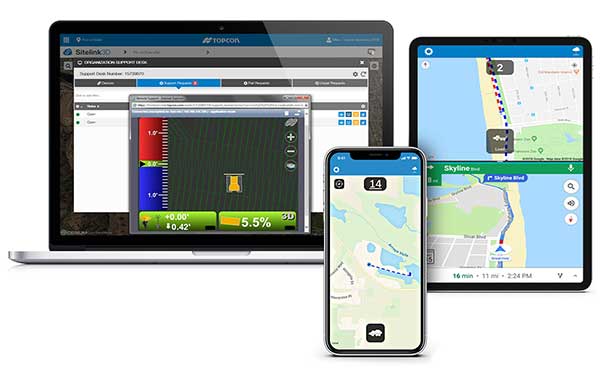
Topcon Positioning Group is offering a new edition of its real-time 3D job site monitoring and management system, Sitelink 2.0. The update includes a new pay-as-you-go point-based service model, new features to Sitelink Support Desk, as well as a new Haul Truck application, the company said.
Version 2.0 includes a newly redesigned web portal that features a consumption-based “Service Point” investment model.
“We are introducing a completely new way to service our customers that allows them to take advantage of a pay-as-you-go account-based system rather than year-long pre-paid subscription-based plans,” said Murray Lodge, senior vice president, construction. “With no expiration date on the Service Points, contractors can be assured their investment will be protected in their personal account and allocated when it best suits their needs.”
Also, new to the service includes remote configuration functionality in Support Desk. It allows Topcon support personnel to directly access and configure receiver components on connected machines, while simultaneously retaining an active remote session of the 3D-MC machine control software.
“We have made support more efficient with less downtime for operators with our team having the ability to go straight into the configuration settings for receivers and make adjustments, minimizing work stoppage on the site,” said Lodge.
The latest version also includes a new Topcon Haul Truck application, which utilizes an Android or iOS app that can be installed on a phone or tablet. It is designed to provide a complete and easy-to-use cloud-based, haul management and reporting system with real-time visibility.
“The new Haul Truck app provides productivity statistics for each haul, including the counts, average distances and the time it takes to complete the process — all within a geofenced pickup site and unloading zone. It is simple to use — drivers come onto the site, quickly enter basic info and get to work,” Lodge said. “With 3D map imagery, operators can view where the load is being picked up and the path it takes to unload and return, and it automatically records for reporting.”