Australia-based Position Partners has launched MiRTK, an open architecture corrections service for GNSS equipment.
Internet-enabled, MiRTK offers an alternative to UHF radio correction services for high-accuracy GNSS. Unlike UHF radios, MiRTK is not limited by range from the GNSS base station and does not require line of sight with the survey rover or machine.
MiRTK uses a small modem that slides onto the accessory slot of the tripod and connects to the base station via a single cable.
A subscription service is available in locations with the Telstra network, mainly continental Australia.
MiRTK is designed for accurate GNSS positioning in the construction, mining and geospatial industries. It is compatible with all brands and models of GNSS from manufacturers including Topcon, Trimble, Leica Geosystems, Sokkia, Hemisphere and more.
“Until now, users that rely on high-precision GNSS for applications such as surveying and machine control had no option but to use UHF radios or a network RTK solution,” said Cameron Waters, geospatial business manager at Position Partners.
“Anyone that’s had to rely on UHF radio frequencies will have experienced problems, including interference, range limitations, costly licensing and severe penalties for breaching licensing laws. MiRTK offers an alternative that is refreshingly simple: no repeaters, no line of sight issues and no complex licensing,” he added.
The Galaxy lithium mine in Ravensthorpe, Western Australia. (Photo: jasonbennee/iStock / Getty Images Plus/Getty Images)
Another benefit, according to Waters, is the ability to utilise a single correction protocol across all GNSS equipment on site. This dramatically reduces complexity and potential connectivity issues. “MiRTK uses NTRIP and a user selectable format such as RTCM3 or CMR, that can be used universally regardless of the brand or model of equipment,” he said. “Users enjoy full speed, full constellation connectivity without the complex radio settings, baud rates, bandwidth or scrambling problems that you get when trying to utilize different GNSS systems with UHF radios.”
To set up the unit, users simply connect the modem to the base station, power the modem on and MiRTK will work for up to 20 hours continuously without charge. Each unit can connect with up to 10 devices such as survey rovers or machine systems as standard, with unlimited potential to scale up connections as required.
“The future of UHF is limited with lower bandwidth, higher density areas, increased governance, rising costs and little flexibility,” Waters said. “MiRTK gives customers a new approach to receive reliable correction data in a simple and hassle-free way, whilst utilizing their existing GNSS hardware.”
Bentley Systems has acquired NoteVault, a voice-based field automation provider for construction management. This acquisition expands Bentley’s Synchro digital construction environment with mobile field applications to track and manage labor, materials and equipment.
According to Bentley Systems, these comprehensive offerings further extend the value of digital twins across construction management, enabling projects to combine immersive 4D models of the construction progress with detailed up-to-date reports on resource expenditures.
NoteVault’s SaaS solution is deployed via mobile devices, offering natural language automated speech-to-text, augmented with automated machine learning, and human transcription to ensure accuracy. Because NoteVault has been engineered specifically for construction site mobile field reporting, it recognizes construction-specific language for accurate transcription, and enables automated translation so non-native English speakers can submit daily reports more easily using their native language.
With NoteVault on their mobile devices, construction professionals can help synchronize status reporting effortlessly while saving time and money, reducing the risk of contractual disputes, Bentley Systems added.
“Digital twins continue to transform the way projects are delivered and operated,” said Dustin Parkman, vice president, project delivery, Bentley Systems. “Inherent in every digital twin is a stream of continuously updated data, and for construction, automating the semantic interpretation of field reports can now be one of the richest sources of live project information. With the addition of NoteVault’s market-leading resource tracking capabilities, the Synchro 4D construction environment delivers the most comprehensive construction digital twin solution available. We are excited to continue advancing the scope of construction digital twins.”
Driven by COVID-19, the uptick in adoption supports collaboration among remote workers as businesses adapt.
The Trimble Connect cloud-based collaboration platform has surpassed 10 million users. In response to COVID-19, distributed working has intensified the need for teams to share information and collaborate remotely, leading 1.2 million users to join Trimble Connect in March and April alone.
To date, Trimble Connect has hosted more than 80,000 design and construction projects, making it possible for people to collaborate and work together from anywhere in the world.
Photo: Trimble
Trimble Connect is an open collaboration platform for design and construction that connects project stakeholders with the data they need to inform decisions and improve team efficiency. Project stakeholders can share, review, coordinate and comment on data-rich constructible models, schedules and critical project information in real time — reducing costly miscommunication and improving coordination to keep projects on time and on budget.
In addition to adding new users, the activity on Trimble Connect has shown a considerable increase in collaboration for businesses in the architecture, engineering and construction (AEC) industry.
The number of invitations to collaborate on projects increased 58% in April over the previous month, indicating that users are adjusting to new remote and distributed working dynamics and enabling teams to stay resilient, despite interruptions to their traditional daily routines.
“This is an exciting milestone for Trimble Connect,” said Ray Bagley, business area director for Trimble Connect. “Businesses in the AEC industry need an open, common data environment that allows project stakeholders to unlock the real value of building information modeling (BIM), civil construction and geospatial data. The increased adoption of Trimble Connect in recent months shows us that businesses need reliable, open collaboration more than ever before.”
Trimble Connect’s open API enables data-flow to and from a variety of applications and allows users to customize workflows by integrating with existing enterprise solutions. Users can access project files stored on Trimble Connect directly through a wide range of solutions, including Tekla Structures software, Trimble Access field software, Trimble FieldLink layout software, SketchUP 3D modeling software and ProjectSight construction management software as well as third-party applications.
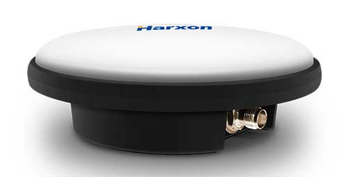
Harxon has launched a ruggedized GNSS antenna for applications subject to high shock and vibration environments such as i-construction machining applications. Integrated with reliable signal tracking and strong anti-interference performance, the IP69K ruggedized HX-CVX600A antenna provides end users with millimeter accuracy, durability and productivity, the company said.
I-construction promotes the use of automated machines on construction sites to improve productivity and provide support to workers.
The Harxon HX-CVX600A offers full support for reliable and consistent satellite signals tracking, including GPS, GLONASS, Galileo and Beidou, QZSS, IRNSS and SBAS, as well as L-band correction services.
By exhibiting a very stable phase center that adopts multipoint feeding technology, exceptional low elevation satellite tracking with symmetric radiation patterns, high gain with ultra-low signal loss, as well as outstanding wide-angle circular polarization (WACP), the Harxon HX-CVX600A performs with remarkable positioning accuracy and provides end users with full control of the job site, performing tasks more productively, meeting tighter positioning specifications, and avoiding rework caused by inaccurate positioning.
The HX-CVX600A GNSS antenna of Harxon also provides superior anti-interference performance. Its advanced low noise amplifier (LNA) excels in improved signal filtering and out-of-band rejection and restrains electromagnetic interference. It also provides strong multipath reduction capacity over all GNSS frequency bands for consistent and reliable GNSS signals, even under complicated environments such as congested urban areas or communication base stations.
The Harxon HX-CVX600A compact and low-profile antenna is Harxon’s first antenna with exceptionally firmness for hash operation environment as construction industry. The upper cover of the antenna is made of material with excellent chemical and high heat resistance. Its aerodynamic enclosure withstands exposure against dust, rain, splash or sunlight. Screws and pole mounts are both available, offering flexible installation.
The Harxon HX-CVX600A ruggedized antenna is now open for pre-sale; contact [email protected].
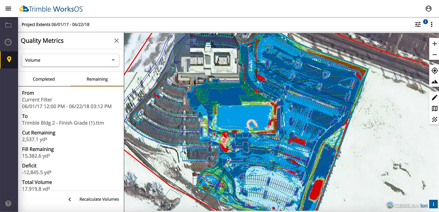
Trimble WorksOS is an upcoming civil construction software-as-a-service (SaaS) operating system. The cloud-based system will integrate data from Trimble and third-party providers across the entire civil construction project lifecycle, including estimating, scheduling, designs and the field.
Beta testing is now taking place for WorksOS, before it is released in the third quarter. Users interested in participating can go to WorksOS.trimble.com.
One-Stop Software. With WorksOS, site supervisors and project managers will be able to log into a single application to track daily production quantities, labor and equipment hours, and equipment maintenance schedules. They will be able to view real-time visibility of cut, fill, volume and compaction data to maximize jobsite productivity.
A user-friendly dashboard enables key personnel, including site supervisors, to adjust daily work targets to ensure work is progressing to plan. Site supervisors will also gain live daily volume calculations, compaction quality metrics and visibility into which machine is working, to monitor progress and determine if the project is on schedule.
Software Connections. Connecting workflows, Trimble WorksOS will integrate Trimble Business Center, Trimble WorksManager, Trimble Siteworks Positioning System, Trimble Earthworks Grade Control Platform and Trimble PULSE Fleet and Equipment Management Software.
According to the company, Trimble Dimensions is the signature event for Trimble’s global user community spanning agriculture, construction, geospatial, transportation, utilities and more. The show highlights technology and how it transforms the way professionals work to achieve success.
“Unfortunately, the overwhelming concerns and ongoing impact of COVID-19 inhibit our ability to deliver a conference that meets the high standards of safety and excellence our attendees expect and deserve,” Trimble said in a press release.
The event was scheduled to take place Nov. 2-4 at the Gaylord Opryland Resort and Convention Center in Nashville, Tennessee. Trimble Dimensions is a biennial event.
New series of free webinars for construction, geopositioning and agriculture facilitate learning
Topcon Positioning Group is launching a free webinar program for the construction, geopositioning and agricultural sectors, exploring key topics affecting the industry and providing the latest updates and project management solutions.
The Topcon Talks series, consisting of numerous informative webinars, has been created in response to the ongoing COVID-19 pandemic and aims to provide those working from home with valuable educational resources, while maintaining steady communication with Topcon customers, dealers and the wider industry.
The webinars will focus on a range of topics such as improving productivity using digital construction workflows, overcoming barriers to technology adoption, and more practical how-to sessions for customers and dealers on specific Topcon solutions.
The webinars will be delivered by a range of Topcon experts, with input from several other industry specialists, and cover a multitude of topics including:
Always One Step Ahead – an overview of Topcon’s latest product developments, market focuses and acquisitions
State of the Industry series – looking at the barriers to technology adoption in construction, such as attracting talent and bridging the skills gap
Detailed technical sessions showcasing latest hardware, software and web services to get the most out of Topcon solutions
The content series is live on the site, with new sessions taking place regularly over the coming weeks. All sessions are free to attend, and those wanting to participate will first need to register on the Topcon website.
“Everyday life has changed very quickly, and businesses across the world are having to adapt. At Topcon, we are working tirelessly to help the industry weather this storm. We’re aware that at this time, the majority of people are working from home, and we want to continue to support our customers and colleagues as much as possible,” said Ron Oberlander, vice president of global professional services at Topcon Positioning Group. “That’s why we’ve developed this webinar series — to provide an opportunity for continued professional development so that professionals can remain as productive as possible during this challenging time and be in the best position possible to accelerate the industry’s recovery when we come out the other side.”
The webinars are also recorded and uploaded to the site once complete, so those who are unable to attend the session can access the content in their own time.
Technology continues to develop and put more capability, data storage and ease of use into many professional’s hands, and surveyors are no different in their needs.
Spatial data collection has become an important task in the diverse service world of today’s surveyor with a variety of platforms, sensors and techniques being used to provide this operation.
The movement toward completing a “digital twin” of existing improvements and facilities worldwide has opened the door for new means and methods for data collection. Surveyors are taking a front-line role in producing the spatial data necessary for much of the internal and external infrastructure being used in today’s cutting-edge digital modeling.
Necessary accuracy and precision
However, not all data-collection systems offer the accuracy and precision deemed necessary by today’s surveying profession. These systems also need to be tough enough to handle the environmental conditions surveyors face in their everyday work, yet be user-friendly enough to make the data-collection process efficient.
Surveyors require a system designed for rugged use, yet built with a high-visibility screen, easy-to-use interface and reasonable battery life to allow effective and confident data collection. Many data collectors tout these features, but many of them fail when subjected to the harsh conditions of surveying and construction sites.
Times, however, are a changing and a new tablet is raising eyebrows.
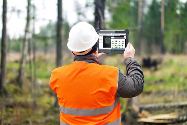
DT Research Inc., a Silicon Valley electronics provider, has provided mobile and medical computing devices to many professions for more than 20 years. They have taken one of their most popular models, the DT301, and added integrated significant upgrades that brings it squarely into the surveying and geospatial world.
This rugged tablet can now include a multi-frequency GNSS module and a second, 3D-capable, stereo-imaging camera for capturing photometric information.
High-capacity, hot-swappable battery pack with power-saving modes
IP65-rated for water and dust resistance
MIL-STD-810G for shock and vibration protection
MIL-STD-461F for EMI and EMC tolerance
Multi-frequency GNSS (including GPS, GLONASS, Galileo and BeiDou)
External GNSS antenna capable
Intel RealSense Depth camera, 2D barcode scanner
Long-range Bluetooth, 4G LTE, digital pen support
Sturdy external keyboard with various mounts for static installation
Rugged yet reasonable weight of 3.1 pounds
Multiple mounting options for precise measurement
Rugged, but not too heavy
The first impression a new user of the DT301X-TR will notice is that while it is heavier than the normal personal tablet, it is very rugged yet not noticeably heavy. The additional weight it does carry, however, gives the user a sense of durability and confidence to take it into fouler environments without fear of infiltration or hazardous climate concerns.
The external bumpers can take significant abuse, and the rubber rear guard is used for gripping the tablet effectively during data collection tasks. Several mounts are available for this unit, including a pole mount in conjunction with the external GNSS antenna for higher accuracy location determination.
This unit runs the Microsoft Windows 10 IoT (internet of things) Enterprise operating system, so most users will already have a general feel for the overall interface. All the normal Windows tools are there (email, browser, etc.), so little training is needed for beginners.
Connectivity is available through dual-band Wi-Fi and/or 4G LTE communications as well as long-range Bluetooth connections where needed. The unit runs on an Intel 8th-generation core processor and SSD storage for fast computing and data access needs.
In addition to computing performance, this model also exceeds expectations with its robust screen. Where most high-def screens on phones and tablets suffer in daylight conditions, the DT301X-TR allows the user to maintain great visibility and keep working with visual confidence.
GNSS module and antenna
The DT301X-TR can be loaded with several data-collection software packages, depending on your application. For traditional surveying, Microsurvey’s Field Genius is used for locating survey points with the GNSS module. Several programs for data collection are available, depending on the accuracy required by the user.
Photo: DT Research
A helical mobile dual-frequency GNSS antenna is mounted directly on the tablet for receiving survey-grade positions with an RTK correction service. The tablet can also be used with an external GNSS antenna mounted on an extendable pole for a more conventional surveyor-style method of data collection while providing stability for the user.
The data-collection process for mapping is intuitive and allows for uploading existing shapefiles for reference to existing conditions. Exporting information after the data-collection task can be completed in two different formats: shapefiles and KML files.
Photo: DT Research
For the higher accuracies typically required for surveyors, the unit utilizes the pole mount to ensure the accuracy level is not compromised by human interaction, and it connects to an external GNSS antenna. The software allows the user to collect more precise locations through several means: static, real-time kinematic from the user’s base station, or through a real-time network solution from an external source.
The data collection process in Field Genius is very user friendly and allows for customized point naming and automatic linework between points. Field Genius also contains standard COGO tools and routines that allow the user to perform field calculations right on the job, saving valuable time and money for the practitioner and the client.
Exporting of field data is robust and allows for creation of DXF/DWG files of linework and LandXML files for surface and point downloads. The user can also export raw data in a GNSS Survey format or the industry standard “field book” format as well. Importing background files is just as simple, so the user can have additional information at their fingertips for reference during their data collection process.
Also, the DT301X-TR can be utilized for construction staking with an extensive array of staking reports available for user verification. Proposed TIN surface models can be imported for site and roadway staking for placing cut/fill points on the fly.
Cameras make it shine
The DT301X-TR, however, is not just a fancy conventional surveying data collector; the Intel RealSense Depth camera and DOT3D Pro software from DOT Product is the latest development to be added to the rugged tablet that makes this platform shine. This latest technology from Intel allows the user to photograph and video spaces that even the newest laser and lidar scanning equipment can’t access.
Stereo depth modeling is enhancing the data-collection process for surveyors as a new tool to collect important information for engineers, architects and contractors. By collecting close quarters information in real time, a more complete BIM and/or “digital twin” data set can be accomplished faster and more cost efficiently than ever.
This version of remote sensing is becoming very popular with other vehicles and platforms (such as UAVs), yet being integrated into a single unit with GNSS capability is key to making the DT301X-TR a game changer.
The divide between the macro (GIS mapping) and micro (traditional surveying) of spatial data collection is closing, but it will take some time before satisfying the surveying community. The DT301X-TR is closing that gap by marrying the accuracy of GNSS measurement with the precision of 3D analyzation technology.
DT Research began by creating a bulletproof tablet made for durability and dependability, but has raised the bar with a state-of-the-art satellite measurement module and remote-sensing capability through the RealSense camera system.
Wrapping all this technology into a rugged unit running on an industry-standard software platform, DT Research has provided an insight to what the future of data collection looks like, no matter what profession one is in.
Topcon Positioning Group is offering a new Thermal Mapper for asphalt paving. It is designed to monitor temperature segregation to prevent future problems and measure performance, as well as provide accurate compliance reporting — all with real-time kinematic (RTK) positioning accuracy.
The mapper records temperature readings behind an asphalt paver as the paving is in progress and provides a visualization to operators in real time of whether the mix falls within a predefined temperature range, and if any segregation is limited within specifications.
“If too much segregation occurs, roads will soon develop major problems. The mapper quickly tells operators if the mix is stable or if moderate or severe temperature variation is occurring. If the readings are unacceptable, operators can adjust for more efficient and accurate project outcomes,” said Murray Lodge, senior VP of construction. “The system’s sensors also bring to the market the first thermal mapping system with RTK GPS positioning for more accurate results than conventional methods.”
The system also creates data reporting files to download for applications such as U.S. Department of Energy compliance through an interactive Pavelink module, the Topcon cloud-based logistics application for asphalt paving.
“We are excited about where Topcon is taking the paving industry with the different solutions we are bringing to market. From SmoothRide, where we scan the existing road to determine the optimal design for variable depth milling and paving to the newly released Pavelink system, we are focused on improving paving.
“Pavelink allows contractors to monitor the entire paving workflow from the batch plant, mixing plant, trucks, to the paver, to the rollers. By connecting the entire process, it allows the contractor to have full control over their projects in real time and make adjustments along the way, instead of after the fact as is so often done with conventional methods. Now, bringing in the heat sensor system into that workflow, we are giving contractors more resources to meet the specifications demanded today.
“It is part of our commitment to revolutionize the planning and management of the asphalt paving process with real-time visibility throughout the project lifecycle,” Lodge said.
What are the key obstacles to widespread adoption of 3D positioning and guidance in the construction industry?
Ismael Colomina, GeoNumerics
“Construction site monitoring with UAVs requires regulated standard scenarios that allow flying over people and in urban areas without spending weeks obtaining the needed permissions. It also requires the development of critical UAV components, especially the guidance, navigation and control (GNC) systems. Safe UAV navigation — guaranteeing positional accuracy with small probabilities of actual errors larger than the specified ones — is still under development and will involve a multi-sensor navigation system. Current GNSS augmentation systems, such as WAAS and EGNOS, may not be appropriate for flights in the very-low-level (VLL) airspace.” Ismael Colomina, GeoNumerics
Members of the EAB
Tony Agresta Nearmap
Miguel Amor Hexagon Positioning Intelligence
Thibault Bonnevie SBG Systems
Alison Brown NAVSYS Corporation
Ismael Colomina GeoNumerics
Clem Driscoll C.J. Driscoll & Associates
John Fischer Orolia
Ellen Hall Spirent Federal Systems
Jules McNeff Overlook Systems Technologies, Inc.
Terry Moore University of Nottingham
Bradford W. Parkinson Stanford Center for Position, Navigation and Time
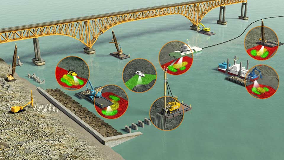
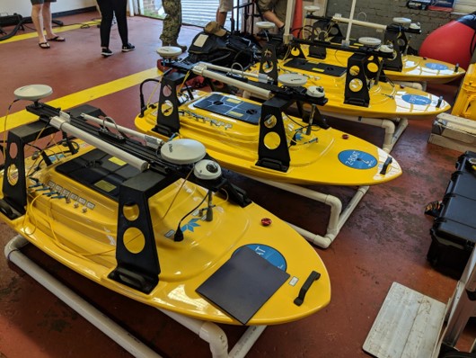
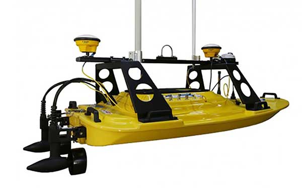
Teledyne Marine has released the Z-Boat 1800-T unmanned survey vessel, equipped with Trimble’s high-precision GNSS heading receiver and compatible with Trimble Marine Construction (TMC) software.
The Z-Boat 1800-T enables marine construction and dredging projects to run efficiently and be monitored in real time anywhere in the world.
The Z-Boat 1800-T, designed and manufactured by Teledyne Oceanscience, is a high-resolution shallow water hydrographic unmanned survey vehicle with the newly released Odom Hydrographic Echotrac E20 Singlebeam Echosounder and dual antenna Trimble BX992 GNSS heading receiver. Each sensor is integrated into a compact, portable and cost-effective package.
The combination of Trimble’s high-precision heading and positioning/guidance paired with Teledyne’s accurate/precise sonars allow for data collection under harsh conditions. Both sensors can be removed and mounted on other watercraft and barges to maximize data-collection capabilities.
The data is remotely viewable in real time, giving the operator full control and confidence. The boat’s small footprint allows access to areas that are too small, confined or unsafe for larger vessels.
Photo: Teledyne Marine
“Teledyne Marine and Trimble continue to create a paradigm shift for marine construction by providing real-time vision, guidance and survey across a project’s complete construction lifecycle — improving safety, eliminating or reducing work redoes, and helping to complete projects faster and under budget. This system provides as-building updates or what we call ‘eyes below the water,’” said Ted Germann, Teledyne Marine’s vice president of Emerging Markets.
“Trimble’s experience in GNSS guidance systems, and Teledyne’s leadership in shallow-water hydrographic surveying provides an ideal solution for marine construction contractors and surveyors,” said Kevin Garcia, general manager of Trimble Civil Specialty Solutions. “The Teledyne Z-Boat 1800T release means that near-shore construction workflows now have a quick mobilization tool to identify sub-surface obstructions, provide ad hoc inspections and increase site safety. This feature-loaded solution makes the unmanned surveying vessel affordable for all sizes of customers.”
Dynapac and Trimble are partnering to develop commercial-ready autonomy functionality for Dynapac soil rollers.
The companies first demonstrated automation of the soil compaction process at this week’s ConExpo 2020 in Las Vegas, and plans another demonstration during the Trimble Dimensions User Conference Nov. 2-4 in Nashville, Tennessee.
The Dynapac CA3600PD single-drum vibratory roller. (Photo: Dynapac)
Dynapac’s “Road to Autonomy” was launched with the introduction of Seismic Soil Rollers in 2019. The Dynapac-exclusive Seismic technology takes the guesswork out of the equation for operators, regarding soil type or frequency settings, the company said.
Dynapac Seismic monitors the soil properties and automatically adjusts the frequency of vibration for optimal compaction and energy efficiency. The Active Bouncing Control System automatically cuts off the vibration of the drum when the material reaches maximum compaction characteristics.
The next step on the “Road to Autonomy” is automatic steering and speed functions on the roller. The operator/site manager can use the machine to map the boundaries of the area to be compacted.
Once the machine is placed in autonomy mode, the system will take over the controls for steering and speed. This functionality will be shown at the Dynapac and Trimble booths during ConExpo 2020.
By automating these functions, operator skill gaps can be bridged, while consistent speed and steering improve compaction quality results.
The autonomous solution is built on Trimble’s control platform and utilizes Trimble’s field-proven positioning technology. Compaction documentation systems, such as Dyn@lyzer or Trimble CCS900 Compaction Control System, work together with automatic speed and automatic steering to provide documentation of the improved quality.