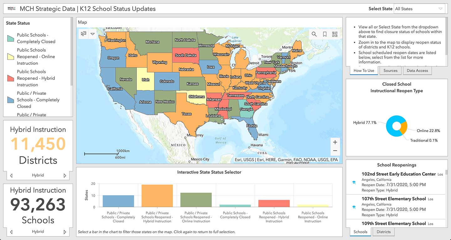
Location intelligence company Esri will be making data layers available on U.S. school closures during the COVID-19 pandemic, through a new partnership with MCH Strategic Data.
To help educational organizations as well as families across the nation better understand the situation in their communities, Esri and MCH have made school closure data accessible from a public dashboard.
Information on K-12 public and private schools include whether they are closed, plans for reopening school buildings, and the type of instruction they are offering during closures due to the epidemic.
MCH Strategic Data compiles and provides institutional information for the education, healthcare, government, and religious sectors.
“These datasets are useful for governments, school officials, and businesses providing leadership, resources, and community programs during the COVID-19 response,” said Ryan Lanclos, Esri director of public safety solutions. “But of utmost importance, this is a source of critical information for the community. It provides transparent and useful information that can help families develop a personal plan when they are feeling their most vulnerable.”
“Our customers depend on us to provide insight to the school market so they can respond effectively and appropriately during this challenging time,” said Kelly Holder, MCH chief information officer. “Our ability to rapidly compile and normalize changing data against our comprehensive U.S. database provides timely insight during an important time in the school planning cycle. This free map and database puts information into the hands of organizations who want to help schools and families now and in the coming months.”
As the COVID-19 outbreak has escalated rapidly across the globe, and with municipalities struggling to respond, MCH and Esri have built out additional resources like the MCH School Status Updates to help organizations quickly visualize and understand the current situation, as well as identify potential community risk areas when schools begin to open back up, and estimate the capacity needed to respond.
The Esri COVID-19 GIS Hub provides much of this essential data, along with case locations and social vulnerability, that communities and health organizations can use to inform their response.
For more information on Esri’s disaster relief support, visit esri.com/disaster.
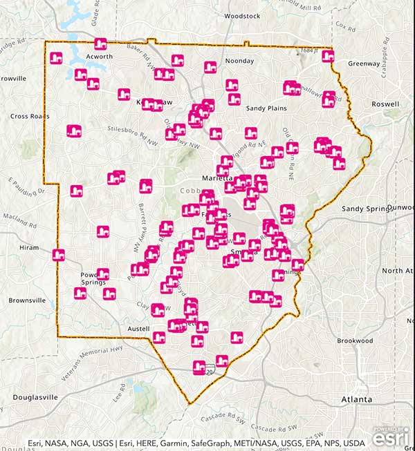
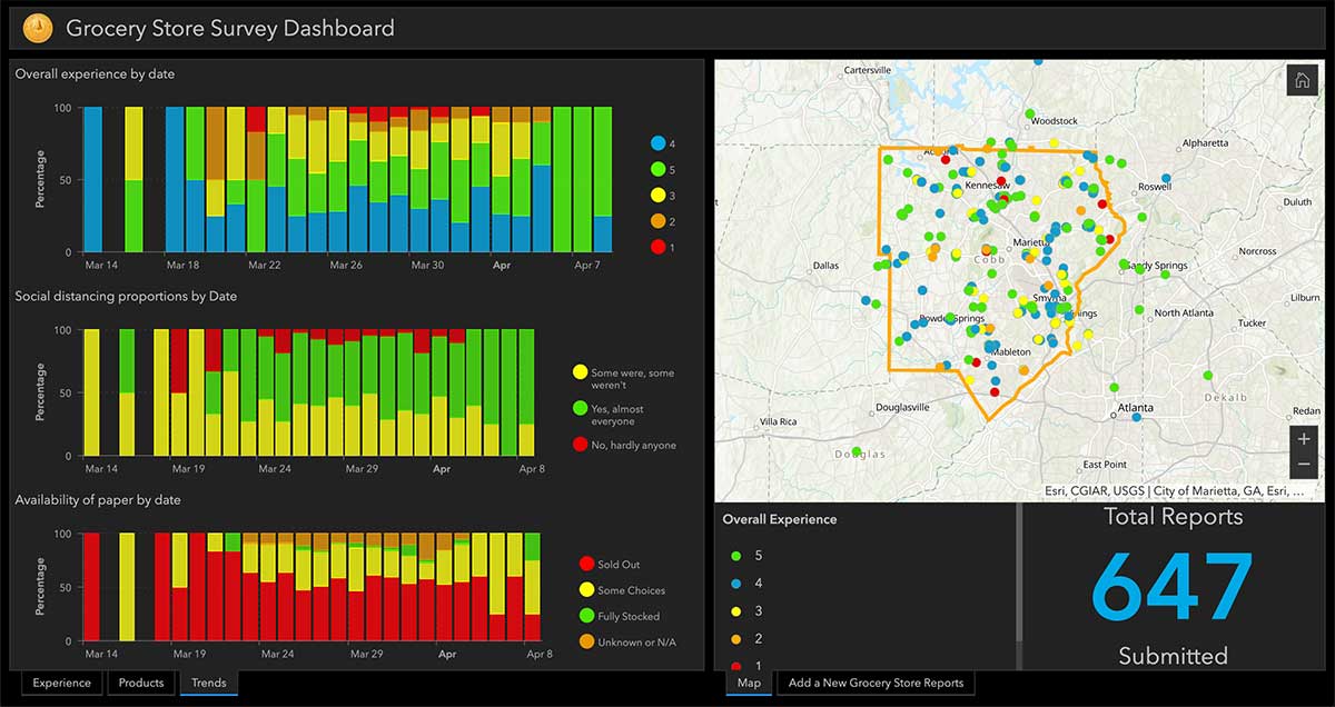
Cobb County, Georgia, is providing its residents with an app that tracks what grocery stores are stocking which essential goods, such as paper products, cleaning items and fresh produce.
The Cobb COVID-19 Grocery Stores and Inventory app gathers input from users, and the data is posted anonymously. Stores can be sorted by distance, senior hours and crowds. Cobb County is a suburb of Atlanta.
The Cobb County Geographic Information System (GIS) department created the app using Esri ArcGIS.
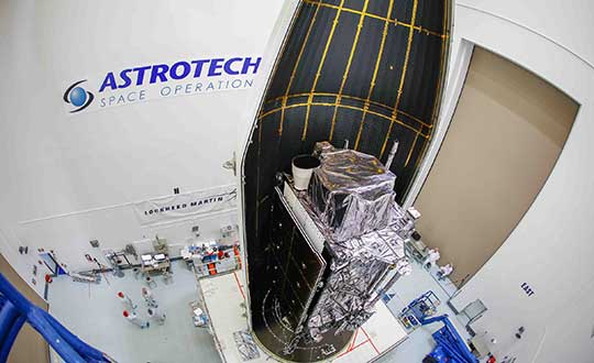
The United States Space Force’s Space and Missile Systems Center (SMC) has decided to reschedule the launch of GPS III SV03 (GPS III-3) from Cape Canaveral Air Force Station to minimize the potential of COVID-19 exposure to the launch crew and early-orbit operators.
Originally scheduled for late April, the launch is now projected for no earlier than June 30, pending a reevaluation in May.
“We do not make this decision lightly, however, given our GPS constellation remains strong, we have the opportunity to make a deliberate decision to maintain our mission assurance posture, without introducing additional health risk to personnel or mission risk to the launch,” said Lt. Gen. John F. Thompson, SMC commander and program executive officer for space.
The Lockheed Martin-built GPS III satellite will be the second GPS satellite launched on a SpaceX Falcon 9 rocket. It will be the first National Security Space Launch mission where SpaceX will attempt to recover the booster, reports Space News.
GPS III-3 brings the third modernized GPS III satellite to the operational GPS mission, and the team remains ready to execute. GPS III will bring three times better accuracy and up to eight times improved anti-jamming capability than its predecessor.
The current constellation is healthy with 31 satellites on orbit, allowing the team to take this strategic pause without gaps in coverage or capability.
“The GPS system supports vital U.S. and allied operations worldwide, unabated. As the COVID-19 pandemic is a threat to national security, likewise, rescheduling the launch is in the interest of national security,” said Gen. Thompson. “We have to get it right the first time, and protecting our people is just as important as cost, schedule, and performance.”
SMC still plans to complete the next three GPS launches this year. The team is taking the necessary steps to protect the health of personnel to allow a swift return to the mission.
“Some of the steps include procedural and facility modifications at the GPS III Launch and Checkout Capability (LCC) operations center and reducing the onsite crew size to provide adequate physical distancing, per CDC guidelines,” said Col. Edward Byrne, chief of Medium Earth Orbit Space Systems Division. “Once these efforts are completed, and the crews have rehearsed and are deemed proficient and ready to execute under these modified conditions, we fully intend to return to our launch cadence for deploying GPS III satellites.”
A leader of GPS III acquisition, SMC’s Production Corps is the United States Space Force’s acquisition office for producing and delivering GPS satellites, ground systems and military user equipment. The Production Corps’ agile program management techniques, smart business approach and close teaming with Lockheed Martin Space are enabling the production and delivery of GPS III’s new civil and warfighting capabilities by 2023. GPS delivers the “gold standard” of space-based positioning, navigation, and timing services vital to U.S. and allied operations worldwide, and underpins critical financial, transportation, and agricultural infrastructure that more than four billion users have come to depend on daily.
SMC’s Launch Enterprise, located at Los Angeles Air Force Base, California, is responsible for the acquisition and operation of launch vehicles, which includes mission assurance and launch safety. The Launch Enterprise is also responsible for leading the effort to certify new entrants to provide launch services for National Security payloads.
GPS III SV03 will be launched into operational orbit by a SpaceX Falcon 9 rocket. GPS III SV03 will be the second National Security Space Launch (NSSL) mission to be launched on a SpaceX Falcon 9 rocket and the first NSSL mission where a Launch Service Provider is recovering a booster.
The Space and Missile Systems Center is the U.S. Space Force’s center of excellence for acquiring and developing military space systems. SMC’s portfolio includes space launch, global positioning, military space vehicle communications, defense meteorological space vehicles, range systems, space vehicle control networks, space-based infrared systems, and space situational awareness capabilities.
SMC continues to deliver vital capabilities to the warfighter and the world, despite the challenges of COVID-19. Recent examples include the successful launch of AEHF-6 on March 26, Operational Acceptance of GPS III SV02 by Space Operations Command on March 27, and the inclusion of SV02 into the operational GPS constellation on April 1.
SpaceX’s Falcon 9 rocket orbited the first GPS III satellite on Dec. 23, 2018. (Photo: SpaceX)
Esri has created and released a suite of resources to help businesses like commercial organizations, government agencies and utilities maintain operational continuity during the COVID-19 pandemic.
According to Esri, these resources are designed to help organizations understand the current status of their operations and employees, analyze relative community risk to COVID-19 and create business strategies for moving forward.
The four released resources include the Coronavirus Business Continuity solution, impact planning for COVID-19, the Health and Medical Lifeline: COVID-19 Risk Model and county-level COVID-19 case data.
The Coronavirus Business Continuity solution includes configurable apps and surveys to enable organizations to track the status and location of their employees and facilities throughout the supply chain and communicate that information with internal and external stakeholders.
Impact planning for COVID-19 provides a snapshot of every U.S. county, including daily updates on each county’s COVID-19 cases and data on population vulnerability, hospital beds and more.
The Health and Medical Lifeline: COVID-19 Risk Model from the Federal Emergency Management Agency ranks counties by high, medium and low risk for COVID-19 vulnerability and risk.
PCTEL has terminated its previously announced share repurchase program. The board of directors does not intend to modify the company’s dividend policy, PCTEL said.
“Given the uncertainty surrounding the COVID-19 virus and its impact on economic and market conditions, the board determined that it is prudent to terminate the share repurchase program,” said David Neumann, CEO of PCTEL. “Maintaining our strong balance sheet will allow PCTEL flexibility to address the unique and evolving challenges presented by the COVID-19 situation.”
In addition, PCTEL also terminated a plan pursuant to Rule 10b5-1 under the Securities Exchange Act of 1934, as amended, that was in place to facilitate market repurchases.
According to PCTEL, under the now-terminated repurchase program, it repurchased approximately 375,000 shares of common stock for an aggregate purchase price of approximately $2 million. Following these repurchases, it had approximately 18.5 million shares of common stock outstanding, the company said.
PCTEL is a provider of wireless technology, including industrial IoT devices, antenna systems, and test and measurement solutions.
Indoor location platform provides municipalities with emergency response and public safety solutions on existing Wi-Fi networks
InnerSpace, a Toronto-based company, is offering its Wi-Fi-based indoor location intelligence platform to support all levels of government. The platform analyzes patterns and movement in public spaces using existing Wi-Fi networks.
The platform is suitable for understanding the movement of people inside public spaces and can support emergency response strategies, social distancing programs and help smart cities implement effective security and public safety measures.
“In response to the global COVID-19 pandemic, we have accelerated the delivery of our public safety solution inFORCE,” said James Wu, CEO, InnerSpace. “Our platform processes RSSI [received signal strength indication] data in real time and returns the industry’s most accurate location data available today. By using public Wi-Fi access points, municipalities have a way to quickly roll out new solutions at city-wide scale.”
InnerSpace inFORCE was selected in a competitive process by the U.S. Department of Homeland Security, for its ability to use Wi-Fi to locate citizens and track emergency responders in an active shooter scenario.
The same platform can be used in a wide variety of emergency situations such as the current COVID-19 pandemic. In addition to the company’s tracking capabilities, it’s analytics dashboard gives public safety offices an unprecedented view into how people leverage public spaces.
“In times of emergency, it is reasonable to prioritize safety and public health to minimize the loss of human life,” said Cerys Goodall, president and COO, InnerSpace. “By providing municipalities with a system that can deliver line-of-sight into how people move in public spaces, we can inform response strategies, improve rescue efforts, and create an infrastructure to support better outcomes.”
InnerSpace inFORCE ingests RSSI data and returns accurate anonymous indoor locations. The information can be connected directly into emergency response communications systems, building management and security systems, or analyzed by InnerSpace to identify critical patterns and trends in people’s movements.
The second GPS III satellite, nicknamed Magellan, has been designated healthy and usable.
According to a Notice of Advisory to Navstar Users (NANU) issued by the U.S. Coast Guard, the satellite has been designated usable as of April 1, 1945 ZULU.
The 2nd Space Operations Squadron (2 SOPS) accepted control of the Magellan on March 27 at the Schriever Air Force Base in Colorado.
Designated Satellite Vehicle Number 75 (SVN75) in the GPS constellation, Magellan is the second GPS III satellite to be accepted into the program, and the first to be accepted during a global pandemic.
The second GPS III satellite is encapsulated before launch. (Photo: Lockheed Martin)
“We’re continuing to make major strides even while working through this pandemic, and we continue to expand our capability to further the program along,” said Lt. Col Stephen Toth, 2 SOPS commander. “This is a huge, momentous occasion for us, that we’re reaching this milestone, that our programs are being delivered, that they’re being executed and the systems are performing as expected. Ultimately, we’re all very excited that we’ve accomplished this major milestone in the program’s history, and we’re very excited for the next things to come.”
The new generation of GPS III vehicles have a 15-year design life and signals that are three times more accurate than the current generation.
“[This means users will have] better accuracy anywhere in the world, with a user’s device being able to determine their location more reliably,” said Capt. Ryan Thompson, 2nd SOPS assistant director of operations.
Additionally, the new satellites have eight times improved anti-jam capability, allowing the military warfighter to operate better in contested, degraded and operationally limited environments.
The vehicles are designed to be forward and backward compatible, which allows them to adapt to the future while remaining fully adaptable to the previous generation of vehicles.
Eight more GPS III satellites are scheduled to launch from now until 2025.
Despite any challenges that may arise, 2nd SOPS remains focused on the mission and continues to make history in space.
“As we’ve moved forward into the Space Force, we’ve taken a bigger mindset approach toward being warfighters,” Toth said. “What COVID has actually brought out of us is the full understanding of what it is to operate with a warfighter mindset. We may not be at war with an enemy per say, but we are definitely at war with the virus. My job is to ensure we continue to provide position, navigation and timing to the world. And we take that very seriously, so despite the virus, we’ll ensure that our mission continues.”
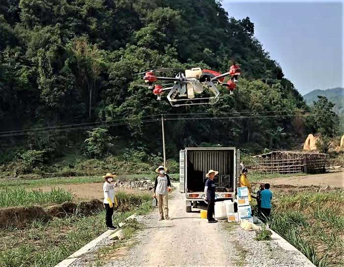
XAG introduces agricultural drones for farmers in China. The XMission drone can reduce costs on fertilizer, pesticides and other treatments. (Photo: XAG/Unicore)
Pesticides, fertilizers and water are the most important means to enhance agricultural crop production.
The prevalent infestation of fall armyworm in China has resulted in reduced yields, threatening food security and the livelihood of smallholders. It’s impractical to conduct manual spraying over farmlands larger than 5 hectares, and this also runs both the risk of wasting large amounts of pesticides and chemical poisoning.
Given the situation, smart agriculture devices such as drones have come in handy for fixing these problems, with minimal environmental impacts. In China, professional farmers and agricultural service providers have already harnessed existing drone technology to conduct appropriate chemical sprays to safeguard the country’s crop production.
The XAG XMission drone has centimeter-level navigation and can operate fully autonomously over complex terrain and easily adapt itself to different spraying conditions for various crop species. Farmers are therefore relieved from much physical effort while no longer risking their health in the battle against fall armyworm.
Equipped with Unicore’s high precision dual-antenna GNSS module (UM482), dual RTK plus GNSS positioning system, real-time centimeter-level flight positioning provides reliable data support in various air tasks. XAG’s drone carries a 4G communication module connected to the XAG Cloud RTK network in order to immediately start missions without setting up portable ground RTK bases.
Unicore UM482. Unicore’s GNSS high precision module (UM482) provides centimeter-level accuracy real-time positioning, with 0.2°, 1-meter baseline course information. UM482 supports single-module dual-antenna signal access and has a dual-RTK engine, enabling high-precision, high-reliability directional heading and dual-RTK real-time positioning, with each RTK engine calculating position independently. This receiver meets the flight needs of different types of UAVs for many different scenarios.
Virus Fighting. XAG’s drones have also joined the fight against the spread of the coronavirus. In Feburary, XAG announced a 5-million-yuan fund for coronavirus response, to be put toward aerial disinfectant sprays to curb the spread of the virus in rural areas. The company’s fleets were used in China’s Shandong province on Jan. 28, where they reportedly disinfected a local community of more than 300,000 square meters in less than 4 hours.
A team of medical researchers and bioethicists at Oxford University published results in Science that offer further understanding of coronavirus transmission.
The evidence is enabling several international partners to assess the feasibility of developing mobile apps for instant contact tracing in record time.
If rapidly and widely developed, the mobile apps could help to significantly slow transmission rates and support countries emerging from lockdowns as restrictions are gradually eased.
Partners include the Norwegian Institute of Public Health (FHI) and NHSX, a joint unit comprised of teams from NHS England and the UK’s Department of Health & Social Care.
Critically, the researchers suggest a mobile app can help slow the spread of infection until vaccines and antiviral treatments become widely available.
“We need a mobile contact tracing app to urgently support health services to control coronavirus transmission, target interventions and keep people safe,” explained Christophe Fraser, Oxford University’s Big Data Institute, Nuffield Department of Medicine, an a lead author on the Science paper.
“Our analysis suggests that about half of transmissions occur in the early phase of the infection, before you show any symptoms of infection,” Fraser said. “Our mathematical models also highlight that traditional public-health contact tracing approaches provide incomplete data and cannot keep up with the pace of this pandemic.”
The project is co-led by David Bonsall, senior researcher at Oxford University’s Nuffield Department of Medicine and clinician at Oxford’s John Radcliffe Hospital. “The mobile app concept we’ve mathematically modeled is simple and doesn’t need to track your location,” Bonsall said.
Anonymous alerts
“It uses a low-energy version of Bluetooth to log a memory of all the app users with whom you have come into close proximity over the last few days,” Bonsall said. “If you then become infected, these people are alerted instantly and anonymously, and advised to go home and self-isolate.
“If app users decide to share additional data, they could support health services to identify trends and target interventions to reach those most in need,” Bonsall said.
The authors argue that a mobile app can reduce transmission at any stage of the epidemic: in countries or regions where the epidemic is just emerging, at the peak of the epidemic, or to support a safe transition out of restricted movement or lockdown.
It could also help to reduce the serious social, psychological and economic impacts caused by widespread lockdowns. Critically, the researchers suggest a mobile app can help slow the spread of infection until vaccines and antiviral treatments become widely available.
Good citizenship
“A contact tracing app can foster good citizenship by alerting people at risk,” Fraser explained. “It can also help ease us out of confinement if we know we’ve not been in contact with anyone infected we can leave home safely, whilst still protecting our loved ones and avoiding a broader resurgence of coronavirus in our community.”
Given the level of infection across much of Europe, the team believe ongoing development of a mobile app partnership across the union would massively reduce transmission and avoid a resurgence in the number of cases, providing an opportunity for all citizens using mobile contact tracing apps to contribute towards ending the epidemic. An app strategy could also be used by low- and middle-income countries, earlier in the epidemic, to rapidly control transmission and get ahead of the epidemic now.
The Oxford team highlight that the mobile contact tracing app should still be combined with isolation of cases, tracing and quarantine of contacts, physical distancing, scaled-up diagnostic testing, decontamination and hygiene measures.
As Bonsall explains “If the mobile app is widely adopted in any country, and combined with other critical interventions such as physical distancing and widespread testing, our models suggest the epidemic could be brought under control. This app is a tool for each and every person affected to contribute towards protecting their health services, supporting vulnerable people and simultaneously gradually releasing communities out of extended quarantine.”
Rigorous ethical standards
Today’s Science study highlights the importance of rigorous ethical standards underpinning the successful and appropriate use of mobile phone technology in addressing the coronavirus pandemic, including a number of ethical requirements needed to foster well-founded public trust and confidence.
“With transparent and inclusive ethical oversight to ensure genuine public trust, it is possible to both save lives and protect civil liberties,” said Michael Parker, director of the Wellcome Centre for Ethics & Humanities and one of the paper’s authors.
“The app should be opt-in, provide secure data storage and privacy protection, and be informed by public and user engagement at every stage of implementation. With these guarantees and, if widely installed by users across a country or regional bloc, a mobile app could even help to end the epidemic,” Parker said.
Official apps only
As mobile apps launch over the coming weeks and months, the Oxford research team urges people to support official apps, developed by trusted institutions, and their partners, such as the mobile contact tracing apps under advanced assessment in several European countries.
Fraser concludes, “Our hope is to support communities with life-saving information as the pandemic worsens and help to release countries from large-scale isolation. The maths is clear: the more people that use a contract tracing app the better chance we have of getting ahead of this epidemic and eventually stopping it in its tracks. If a country reduces the epidemic growth rate to below zero, the epidemic will rapidly decline and eventually stop. Together we can make this possible.”
Download results
Results of a mobile-app-focused survey from a large representative sample of the UK population (1,055 respondents) conducted March 20-22 are available here. Other country surveys are also available for Italy, Germany and France, currently in each language.
The European GNSS Agency, based in Prague, is providing on its website a list of location-enabled applications that it considers potentially useful in response to the COVID-19 pandemic.
The applications range from those helping public authorities understand the dynamics of the outbreak to supporting citizens in their everyday lives by checking supermarket lines.
The apps are sorted into four categories:
Tracking the COVID-19 pandemic
Queue management
Response management
Information dissemination
If you are an application developer and you want to add your app to the list, contact [email protected].
Drone Delivery Canada is reaching out to the healthcare industry for use case applications for drone deliveries related to COVID-19.
The Toronto-based company, which has been designated an essential workplace by the Ontario Provincial Government, seeks use cases from health care organizations (hospitals, seniors’ homes, medical labs and related organizations).
If organizations in healthcare and related industries have a use case, they should reach out immediately to DDC at [email protected] and also contact their local government official to support their use case.
“In the news we are seeing COVID-19 related drone applications around the world, and Canada can particularly benefit from having DDC, a drone logistics leader, in its own backyard,” said Michael Zahra, president and CEO of DDC. “The current situation is an ideal use-case for our proven drone logistics solution to: limit person-to-person contact; bring needed medical and pharmaceutical supplies to Aboriginal, remote, rural and suburban communities; transport blood samples to laboratories for testing and deliver other relevant supplies needed for Canada to effectively manage the current situation.”
ARPAS-UK — the Association of Remotely Piloted Aircraft Systems UK — is requesting the nation’s drone operators to let them know whether they could help fight the battle against coronavirus.
“We are aware there are thousands of Commercial Drone Operators out there; we may need your help,” ARPAS-UK said in a statement to the drone industry.
ARPAS-UK said it is “working hard to push the capabilities of the drone industry and making sure that government departments are reminded of the expertise and capabilities of the drone community in the UK.”
ARPAS-UK is especially targeting relief for emergency services, as well as delivery of emergency food and medicine to vulnerable people, spraying of disinfectant, and collection of imagery and video to help monitor various situations.
Current activities that could be expanded include vital inspections necessary to keep infrastructure running or maintain safety, such as monitoring following floods or environmental activity, and monitoring gas levels on sites.
ARPAS-UK is creating a secure database of the information that will be destroyed when no longer required. To fill out a form for the database, visit this page.