To prevent the further spread of COVID-19, the world is shifting to a “new normal” in which social distancing is practiced and contact between people is avoided. Due to early evidence suggesting the spread of COVID-19 is much more aggressive indoors than outdoors, many companies have begun efforts to monitor workers’ movements and trace contacts to keep offices and factories from becoming new epicenters of infection.
The Need to Monitor
Keeping a safe distance from others and avoiding contact is essential to prevent getting infected with COVID-19. However, there are many situations where avoiding contact with others at indoor locations such as offices and factories is difficult. Hence, there is a growing need for technologies that monitor contact between workers and their movement histories in real time.
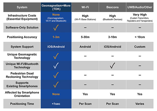
Indoor location information can be obtained using various wireless communication technologies including Wi-Fi, Bluetooth and ultra-wideband (UWB). For example, Bluetooth beacons have been deployed at commercial facilities to enable services that provide location-relevant information to customers with smartphones. The positioning accuracy of Bluetooth, however, is only around 3 to 10 meters and is dependent on infrastructure installation.
To be useful for contact tracing of infectious diseases, the number of beacons must be increased to achieve an adequate level of accuracy. UWB technology features high positioning accuracy, but deployment in a wide area would require installation of a large number of radio transceivers and repeaters, putting it at a cost disadvantage.
Solution Based on Geomagnetism
Given this background, a solution using geomagnetism is attracting attention. TDK has developed VENUE, which displays the real-time locations of people by utilizing geomagnetic sensors found in today’s smartphones. Each indoor location has a geomagnetic signature that can be used to ascertain the position of the phone.
There are several approaches to indoor positioning, but geomagnetism, tightly coupled with inertial navigation, optimally balances accuracy, reliability and cost of deployment and maintenance.
“The beauty of geomagnetic positioning is that it works in all large venues whose structures interfere with Earth’s magnetic field, making this an infrastructure-free approach to indoor positioning that is accurate to better than 2 meters,” said Chris Goodall, founder and managing director of Trusted Positioning Inc., a TDK Group Company based in Calgary, Alberta, Canada.
VENUE provides a position display with even higher accuracy by combining geomagnetic information with information from accelerometers and gyroscopic sensors inside smartphones.
VENUE requires only the creation of a geomagnetic map that combines an indoor layout map with the geomagnetic data of that particular location acquired through a survey, with no need to install new devices and terminals. This leads to low installation cost. The accuracy of positioning using geomagnetism is better than two meters (6 feet) — sufficient for tracing contact with infected persons. In addition, VENUE provides a position display with even higher accuracy by combining geomagnetic information with information from accelerometers and gyroscopic sensors inside smartphones.
“People may hold their smartphones while walking or put them in their pockets or bags,” Goodall said. “Since the orientation to the user changes constantly, the movements and pedestrian use cases need to be corrected using inertial sensors. Solving these issues was the greatest challenge for practical applications such as tracking, and took our team many years to create, perfect and protect.”
Comparison of indoor location information technologies. (Chart: Trusted Positioning)
Real-World Trial Under Way
Beginning in August, a contact tracing trial among workers is being conducted at TDK’s headquarters in Nihonbashi, Tokyo, using VENUE. Employees carry smartphones with a special app installed, and their positions and movement histories on the floor are combined with anonymous identification information. If an employee is found to be infected, the data will be analyzed to identify people who had contact with that employee within the preceding two weeks, and measures such as stay-at-home instruction will be taken.
This solution not only can identify those who were in close contact with the infected person as primary contacts, but also trace those who stayed in areas where the infected person had been shortly before as potential “area contacts.” Analysis that combines location and elapsed time enables more effective contact tracing by improving primary contact tracing indoors and enabling area-based contact tracing over time.
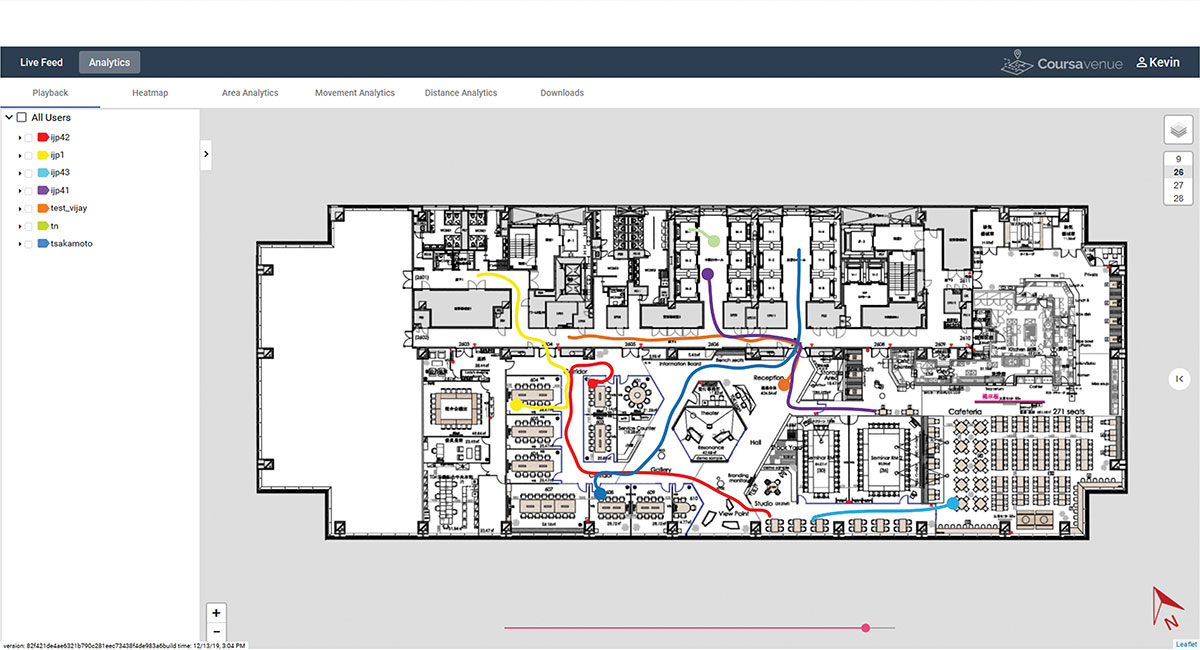
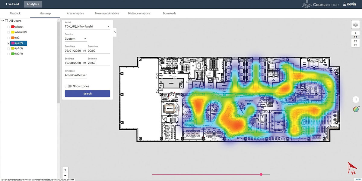
Ongoing Trial at TDK Headquarters: VENUE displays an individual worker’s tracking data on the dashboard. (Conceptual illustration: Trusted Positioning)Ongoing Trial at TDK Headquarters: A worker’s durations of stay and positions can be visualized in the form of a heat map. (Conceptual illustration: Trusted Positioning)
New Possibilities Opened
Because VENUE can display the positions and histories of people and objects using not only workers’ smartphones but special tags containing geomagnetic and inertial sensors (under development), it can be deployed for a wide range of applications beyond contact-tracing of infectious diseases. Possible uses include monitoring the flow of employees to improve operational efficiency or tracking positions of equipment to manage their operational statuses. TDK is working with a number of companies on solutions to improve business efficiencies using location information.
Many offices have introduced open seating, so maintaining a “real-time seating chart” using VENUE is a real advantage so staff can more easily find one another in large office settings, encouraging more collaboration between staff and departments.
Companies have been using Bluetooth low-energy (BLE) beacons to manage the movement of workers, materials and equipment indoors in warehouses, factories and construction sites. VENUE can reduce the installation and maintenance costs of such systems, especially in large-scale facilities.
VENUE is also useful for other contact-tracing applications that do not focus on viral transmission, such as human-to-machine, human-to-vehicle and human-to-robot contacts. The future work environment will undoubtedly change with more automation, and the interaction of humans and machines poses safety concerns. VENUE’s designers hope it can improve safety in many types of contact-tracing applications.
Similar to the expansion of GPS for outdoor positioning applications, indoor positioning technologies will likely grow in our everyday lives. VENUE is one indoor location information solution that enables highly accurate location information to be obtained while keeping infrastructure costs down.
I spent much of the 1980s working for Magnavox Government & Industrial Electronics Company, which held a number of patents on the GPS system and also developed prototype GPS user sets for the military. I, and others at the company, often gave presentations to industry groups talking about the many commercial and consumer applications for which GPS would be used as the cost and size of GPS receivers declined. By the early 2000s, the applications we had envisioned had been far surpassed.
In the early 1990s, I spent several years at Teletrac, now Teletrac Navman, which was beginning to market a vehicle tracking solution based on its own proprietary time-difference-of-arrival (TDOA) technology, using in-vehicle devices and metro-area-based receiving/transmitting towers. One day, the co-founder and chairman of the company roamed into my office for an update on sales and marketing progress. I changed the subject and, at some risk to my job, said “Dennis, the future of location technology is GPS. It will not just be used to locate vehicles, but even cellular phones. With teams of talented engineers focused on reducing the size and cost of receivers and adapting them to specific applications, ‘the sky is the limit’.” He didn’t fire me, but spent the rest of our discussion telling me why I was wrong — that GPS receivers would always be too large, too expensive, too susceptible to signal blockage, and other limitations.
Thirty years later, the applications I had envisioned for GPS have been greatly surpassed and are constantly expanding. In recent years, my primary focus has been on researching the growth and trends of the commercial telematics market in the U.S. and abroad. Today, in the U.S. alone, some 16 million GPS devices are being used to monitor fleet vehicles and assets, such as trailers and heavy construction equipment. Even in the face of the COVID-19 pandemic, the market remains stable and is on track to grow for the year.
In the future, GPS will play an essential role in the deployment of autonomous vehicles, with help from other technologies needed to optimize location accuracy and reliability. My hat is off to the founding fathers of GPS who include some of the most brilliant technologists of this era.
The 60th meeting of the U.S. Civil GPS Service Interface Committee was held Sept. 21-22, utilizing a virtual meeting platform. This was an opportunity for anyone in the world with access to a computer to attend these public meetings of the U.S. Civil GPS Program.
For readers who were unable to attend, a synopsis of the meeting is provided below. The full agenda and presentations are available for download from the GPS.gov website.
The meeting of the CGSIC is an annual event, free and open to the public, conducted to provide updates from U.S. GPS program officials and ensure effective information exchange between the U.S. government and civil GPS users. The two-day meeting is hosted by the U.S. Department of Transportation (DOT) and the Coast Guard Navigation Center (NAVCEN). DOT serves as the civil lead for GPS and chairs the CGSIC in this capacity. NAVCEN is assigned duties as Deputy Chair and Executive Secretariat for the CGSIC.
Subcommittees of the CGSIC for Timing, International Information, and Surveying-Mapping-Geosciences held meetings on Sept. 21, and a summary of these meetings was presented during the CGSIC plenary session conducted on September 22nd.
Major General John E. Shaw, Combined Force Space Component Commander, U.S. Space Command, and Commander, Space Operations Command, U.S. Space Force, provided the keynote for this year’s plenary session. This address was followed by comments from Colonel Curtis Hernandez, Director of National Security Space Policy on the National Space Council and briefings from a variety of other government agencies.
This year’s meeting was replete with briefings from all over the world including an explanation in the International Information Subcommittee of COVID-19 Tracking in South Korea from the Deputy Director of the Korea Ministry of the Interior and Safety.
Everett Hinkley from the U.S. National Forest Service spoke in the Surveying, Mapping and Geosciences Subcommittee showing how the National Remote Sensing Program supports a variety of business areas of the Forest Service including how they are tracking the spread of the Mountain Pine Beetle infestation in our nation’s forests.
The Timing Subcommittee provided an engaging presentation on the current and future plans of the National Institute of Standards and Technology’s new Network Time Services.
Presentations during the plenary session focused on the operational status of the GPS constellation and ground control system modernization, U.S. Space-Based PNT policy, GPS augmentation systems, U.S. engagement with other international GNSS providers, PNT resiliency efforts, as well as a variety of topics related to the status and progress of ongoing GPS programs in the U.S. government.
If you have suggestions for topics to include in upcoming CGSIC meetings, would like to present a topic, or if you found information from past meetings useful and would like to hear more, please contact us via our Navigation Center “contact us” form. Please be sure to select “Civil GPS Service Interface Committee (CGSIC)” from the pull-down menu.
From a GPS operational perspective, civilian non-aviation users can submit GPS-related inquiries or report signal interference or degradation to the U.S. Coast Guard Navigation Center online or to the 24-hour watch desk at 703-313-5900.
Civil aviation users within the United States should contact the Federal Aviation Administration for GPS user support. The GPS Operations Center at Schriever Air Force Base, Colorado, is the Department of Defense lead for operational issues and questions from military users of GPS.
Rick Hamilton CGSIC Executive Secretariat GPS Information Analysis Team Lead U.S. Coast Guard Navigation Center
According to a study by Future Market Insights, the contact tracing applications market is set to grow 15% CAGR through 2030.
“Functional advantages of contact tracing applications include superior data quality, easier tracking and monitoring of larger numbers of people in a time effective manner, the ability of real time analysis, and the significant improvements to management and coordination of manual contact tracing teams,” said a lead analyst at Future Market Insights.
Key highlights noted in the report include that the market for contact tracking applications is projected to display exponential growth through the forecast period on the back of the ongoing coronavirus crisis; decentralized, Bluetooth-based applications are likely to gain strong traction as a result of data privacy concerns; Android platforms are likely to contribute significantly to adoption owing through higher penetration of associated smartphone models; and Europe is expected to be a prominent market, with East Asia showing lucrative growth prospects on the back of mandatory use in China.
COVID-19’s impact on the contact tracing applications market
The COVID-19 pandemic has played a role in the contact tracking application market’s growth: according to the study, the pandemic has been the primary driver for the development, deployment and adoption of contact tracing applications. Government initiatives toward social distancing and patient tracking has influenced the industry’s growth, as well.
The study also has projected an increase in disease control applications as a result of the COVID-19 pandemic.
According to the study, countries such as Ireland and South Korea have been able to use contact tracing applications to gain promising results towards breaking chains of coronavirus patients, limiting the risks of community transmission.
Despite the market’s growth, demand for these applications has been limited to countries with high rates of smartphone penetration. In addition, ethical problems in terms of transparency, privacy and accountability have restrained adoption during this period.
“However, prospects for contact tracing applications remain positive for the post-pandemic era, owing to potential for use in controlling other infectious disease outbreaks worldwide, albeit at a smaller scale,” the report said.
This report analyzed various strategies employed by major companies operating in the contact tracing applications market. Some of the participants operating in the contact tracing applications market include IBM, Oracle, Microsoft, Apple, T-Systems, SAP SE, Salesforce.com, Siemens AG and ServiceNow.
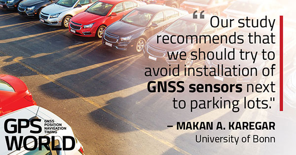
Parked cars near ground station decreased accuracy from 2 to 4 centimeters
A new study shows that the quality of GNSS reflectometry measurements may have improved significantly during the pandemic because of the lack of cars parked near the ground station, according to Science Daily. GNSS reflectometry is used for earthquake early warning systems, determining flood risks, and many other geodesy applications.
The study, carried out by geodesists from the University of Bonn, investigated the location of a precise GNSS antenna in Boston, Massachusetts.
GNSS reflectometry works well if the surrounding ground is flat, like the surface of a mirror, study author Jürgen Kusche explained to Science Daily. “But many GNSS receivers are mounted on buildings in cities or in industrial zones. They are often surrounded by large parking lots — as is the case with the antenna we investigated in Boston.”
The researchers show that parked cars significantly reduced the quality of the elevation data by scattering the GNSS signals, causing them to be reflected several times before they reached the antenna, like a cracked mirror. This reduces signal intensity and provides “noisy” data — hard to correct with pattern recognition because the parked cars change positions every day.
“Before the pandemic, measurements of antenna height had an average accuracy of about 4 centimeters due to the higher level of noise,” Makan Karegar told Science Daily. “During the lockdown, however, there were almost no vehicles parked in the vicinity of the antenna; this improved the accuracy to about 2 centimeters.”
While GNSS stations were historically installed in sparsely populated regions, recent installations have been in urban areas to support engineering and surveying work.
“Our study recommends that we should try to avoid installation of GNSS sensors next to parking lots,” Karegar said.
Citation. Makan A. Karegar, Jürgen Kusche. Imprints of COVID‐19 lockdown on GNSS observations: An initial demonstration using GNSS interferometric reflectometry. Geophysical Research Letters, 2020; DOI: 10.1029/2020GL089647
The COVID-19 pandemic has brought uncertainties to all businesses, and the mapping industry has been no exception.
Slowdowns were observed during the first few months of 2020 as lockdowns were gradually enforced in Asia, then Europe, and finally the Americas.
As expected, projects were delayed during that initial period as companies were reorganizing their operations to allow for remote work.
Once that transition was overcome, a great number of projects resumed, and the geospatial field has been gradually coming back to normal since then. That can be explained by different factors, including, for example, several governments accelerating infrastructure projects to stimulate the economy.
A lot of mapping firms have turned the pandemic into an opportunity to improve their processes. Slower times allow reviewing production workflows and assessing bottlenecks. Once identified, new hardware and software solutions can be evaluated to optimize production.
Interestingly, the resulting investments into new solutions has been significant. Companies are seeing a quick payoff as their workload is rapidly accelerating, leading to an increase in their bottom line.
Overall, the mapping industry was able to rapidly adjust to the new reality caused by the pandemic. The changes that are being made in performing projects not only allow us to minimize risks in the short term, but also to increase profitability in the longer term.
SimActive is the developer of Correlator3D software, a patented end-to-end photogrammetry solution for the generation of high-quality geospatial data from satellite and aerial imagery, including drones. Correlator3D performs aerial triangulation (AT) and produces dense digital surface models (DSM), digital terrain models (DTM), point clouds, orthomosaics, 3D models and vectorized 3D features.
Powered by GPU technology and multi-core CPUs, Correlator3D ensures high processing speed to support rapid production of large datasets.
SimActive has been selling Correlator3D to leading mapping firms and government organizations around the world, offering cutting-edge photogrammetry software backed by exceptional customer support.
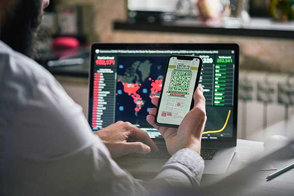
GPS technology is doing far more than helping us navigate or receive accurate time. It is now being used to fight the spread of the global COVID-19 pandemic.
Global navigation satellite systems are being used to collect big data on travel and contact, but they are also being used in more unconventional ways: for example, quarantine enforcement and sanitation technology.
Read on to learn about a few recent developments in the world of GNSS/GPS that are bolstering the battle against the novel coronavirus.
Electronic monitoring enforces quarantine
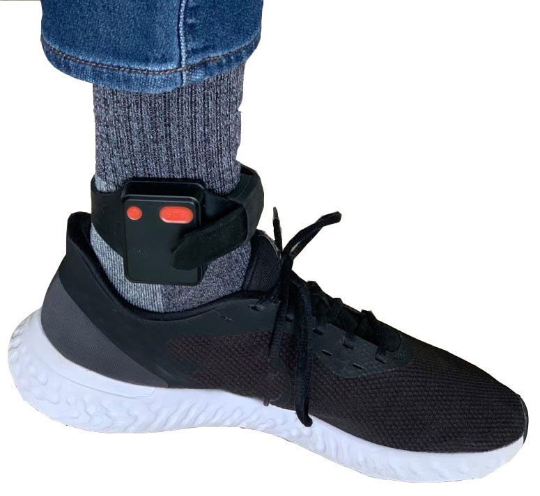
There is a surge of applying ankle monitors to track sick individuals and deter them from spreading the virus further. According to BloombergBusinessweek, one business is thriving because of it: providers of electronic ankle monitors.
Kentucky courts are requiring GPS ankle monitors for people who test positive for COVID-19 and refuse to self-quarantine. Kentucky couple Elizabeth and Isaiah Linscott were two of a growing number of people placed under house arrest after Elizabeth tested positive for COVID-19 and denied signing the Self-isolation and Controlled Movement Agreed Order, a health department document promising she would stay home.
Photo: Regulus Cyber
Elizabeth told Louisville television station WAVE 3 News that she did not sign because she disagreed with the wording of the document. She said that she was concerned about having to contact the health department before traveling, even in the case of an emergency.
“My part was if I have to go to the ER, if I have to go to the hospital, I’m not going to wait to get the approval to go,” she said.
A few days after Elizabeth refused to sign the paperwork, her husband opened their door to an entourage of law enforcement officers serving them with a Health Department order to wear ankle monitors.
“I open up the door, and there’s like eight different people, five different cars, and I’m like ‘what the heck’s going on?’ This guy’s in a suit with a mask. It’s the Health Department guy, and they have three papers for us. For me, her and my daughter,” Isaiah said.
The Linville family is now confined to a 200-foot radius. If they leave their designated quarantine area, their ankle monitors will alert law enforcement.
Alternative to prison
The number of people on house arrest in the United States and across the world has surged as corrections departments struggle to slow the spread of the coronavirus within prisons. An estimated 25 to 30 percent more people are wearing ankle monitors in comparison with a few months ago, according to Bloomberg Businessweek. The U.S. Federal Bureau of Prisons reported a 160 percent increase in home confinement from late March to July. European corrections departments have similarly put thousands of inmates on house arrest in the last few months.
“Demand has spiked everywhere,” BI Inc. monitoring equipment executive Robert Murnock said to Bloomberg. “We’re getting calls from different jurisdictions and other countries we’ve never worked with.”
Efforts to reduce crowding in prisons mean that the electronic monitoring industry is one of very few industries benefiting financially from the coronavirus pandemic.
“Coronavirus gives electronic monitoring companies an opportunity like they’ve never had before to expand,” parole reform expert James Kilgore said.
On Aug. 3, Singapore announced the rollout of electronic tracking devices to enforce quarantine. Travelers will be required to wear GPS and Bluetooth-powered tracking devices that notify authorities if quarantine is broken or the device is tampered with. The rule went into effect on Aug. 11 and applies to all incoming travelers — resident or nonresident — over the age of 12.
On Aug. 20, the premier of Western Australia, Mark McGowan , said his government could soon force people in hotel quarantine to wear electronic monitoring equipment if they are deemed a risk. “If we identify people who are potential flight risks or who might have a criminal history, we are looking at applying monitoring bracelets to them,” he said.
An estimated 25 percent to 30 percent more prisoners are wearing bracelets now compared to the pre-outbreak period. In the U.S., the Federal Bureau of Prisons has placed about 4,600 inmates in home confinement, a 160 percent increase since the end of March.
“Demand has spiked everywhere,” said Robert Murnock, vice president for partnership development at BI Inc., a provider of EM technology.
The emergency shift to electronic monitoring spurred by COVID-19 may foretell a long-term shift toward use as an alternative to prison time, reducing clutter and the risk of the virus spreading among inmates.
Photo: LeoPatrizi/E+/Getty Images
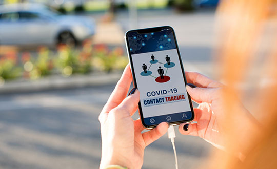
Contact tracing via mobile phones
Israel is using covert mobile phone data to track the spread of COVID-19. On July 1, the Knesset approved a bill temporarily reauthorizing mass surveillance of coronavirus-infected citizens by the Shin Bet, Israel’s internal security service. The original program lasted from mid-March to June 9.
The contact-tracing program works like this. When a patient is diagnosed with COVID-19, the Israeli Health Ministry provides their personal information — including their mobile number — to the Shin Bet. The Shin Bet then consults a classified database of every person who uses Israeli telecom services to determine who came into contact with the infected individual for more than 15 minutes at a time. After the Shin Bet sends information back to the Health Ministry, the Health Ministry notifies those people via text and tells them to self-quarantine.
The Shin Bet’s newfound role in public health enforcement is quite different from its usual focus. Former Shin Bet agents say the COVID-19 mobile phone tracking technology was originally developed as a counterterrorism measure, and the tracking system being used on Israeli civilians is almost identical to that used for suspected terrorists.
“It’s the same system, the same methods,” retired Shin Bet agent Arik Brabbing said to BBC. “We know that someone was here in the park. We can get from the [mobile phone] company all the details about the hour, the place, exactly the place… and we can understand who else was around.”
Supporters of the mass surveillance program, including Prime Minister Benjamin Netanyahu, argue that reduced privacy is necessary to curb the spread of the virus. However, the Israeli government has come under fire by opponents who claim that the program is intrusive and undemocratic.
Israel’s contact tracing procedures are more secretive than those of South Korea and Taiwan, other countries that mandate central mass surveillance. South Korea and Taiwan both enforce quarantines with mobile-phone tracking, and both have built publicly available COVID-19 data platforms.
The South Korean government has disseminated detailed — but anonymized — information about COVID-19 carriers, including their travel routes and treatment facilities. Citizens broadly support these measures — a testament to collectivism in Korean culture.
Civic engagement and enthusiasm for fighting the pandemic is also remarkable in Taiwan, where the public has been collaborating with the government on a town hall-style website called vTaiwan. Citizen-led initiatives, like a GPS-powered tool for tracking face mask supplies, have been applied nationwide.
Meanwhile in Europe, eight major telecom companies, including Vodafone and Orange, have been supplying anonymized metadata to the European Commission to model and predict the spread of the virus. In the United States, the Centers for Disease Control and Prevention is soliciting GPS data from mobile advertising companies rather than carriers themselves.
The two tech giants, Apple and Google, made it easier for health agencies to join its coronavirus exposure notification system, creating a new built-in app within iOS and Android. The app provides real-time notification to users when they are exposed to a sick person.
Virus-killing robots may roam the streets
GPS-based robots, drones and autonomous cars are being deployed to sanitize outdoor spaces, transport medical equipment, and announce safety information to the public.
Robots began rolling around the streets of Wuhan, the original epicenter of the coronavirus outbreak, as early as January. China was the first to deploy robots of this type, but India, Spain, France and other countries have followed in their footsteps. In addition to the chemical-spray approach, some companies are pioneering mobile disinfection robots armed with large ultraviolet-C germicidal lights.
Apollo, the autonomous vehicle company of multinational internet giant Baidu, has partnered with Chinese self-driving startup Neolix to transport food and supplies to Beijing Haidian Hospital. Every morning at 10:30 a.m, an unmanned car delivers meals to about 100 frontline workers. The process eliminates direct contact, protecting the safety of food service workers, hospital staff, and patients.
Zhangjiang Artificial Intelligence Island
A fleet of Apollo and Neolix’s unmanned cars is also responsible for disinfecting all roads on Zhangjiang Artificial Intelligence Island, an 100,000-square-meter industrial complex in Shanghai. The vehicles are loaded with up to 160 liters of spray disinfectant and can cover the island’s entire road system in about half an hour.
The vehicles at Zhangjiang AI double as nighttime surveillance bots. They patrol the island and make sure that guests are adhering to coronavirus protocols, alerting security personnel if they note suspicious activity.
In addition to using drones to spray disinfectant, South Korea’s government has leveraged the technology for public announcements. On July 4, 300 drones lit the sky above Seoul in a show of appreciation for frontline workers. The drones executed a 10-minute synchronized show that included images of face masks, hand washing, and social distancing.
Summary
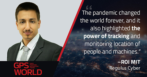
As COVID-19 continues to ravage the globe, governments rely on GPS to track the virus, contain it, and fight against it. The battle against coronavirus is still being waged on a global scale, utilizing GPS as a weapon along with many other existing technologies.
The pandemic changed the world forever, and it also highlighted the power of tracking and monitoring location of people and machines. It is another testament to the immense reliance on GPS technology in our modern world.
The increased deployment of these technologies necessitates increased security measures, especially when public health is on the line. Regulus Cyber offers GPS Cybersecurity software. To read more about it, visit www.regulus.com.
The Urban and Regional Information Systems Association (URISA) will be hosting GIS-Pro 2020, the association’s 58th Annual Conference, Sept. 29 to Oct. 2 in a virtual format. The event was originally scheduled to take place in Baltimore, but URISA chose to hold it virtually because of the COVID-19 pandemic.
“With the serious COVID-19 health and physical distancing concerns, hosting an in-person conference this year and putting members, presenters, and staff at risk was a non-starter,” the organization said.
Keynote speakers for the event include Martin O’Malley, the former governor of Maryland; Chris Vaughan, geographic information officer at the Federal Emergency Management Agency; and Juliana Blackwell, director of the National Geodetic Survey.
According to URISA, the program also will highlight a number of relevant topics, including public health, community resilience, equality and social justice, GIS leadership and ethics.
Here’s an overview of the program:
Wednesday, Sept. 23
• Best Practices for GIS Project Planning and Management
• NG911 & the GIS Workflow
• GIS in Emergency Management
• Microsoft Project Software Tutorial
Thursday, Sept. 24
• Experimental Learning Techniques to be More Effective
• Introduction to GIS for Equity and Social Justice
• Navigating a Virtual Landscape for your GIS Career
Tuesday, Oct. 6
• Building Community Using Geospatial Tools
• Unpacking the NENA NG911 GIS Data Model
• Changes Afoot After 2022: State Plane and the Death of the U.S. Survey Foot
Wednesday, Oct. 7
• Preparing for GISP Certification
• Coordinate Systems and Projections
Sessions also will be available on demand for GIS-Pro 2020 registrants after the conference, URISA said. Register for the event here.
In previous years, the Civil GPS Service Interface Committee (CGSIC) took place right before the start of the ION GNSS+ conference.
This year, the U.S. Department of Transportation (DOT) and the Coast Guard Navigation Center (NAVCEN) are holding the 60th meeting virtually, in collaboration with the Institute of Navigation (ION).
The meeting will take place Sept. 21-22 online before the annual ION GNSS+ conference, which will also take place virtually because of the COVID-19 pandemic.
All CGSIC meetings are free and open to the public. Anyone in the world with access to a computer can attend these public meetings of the U.S. Civil GPS Program.
DOT serves as the civil lead for the GPS program and chairs the CGSIC in this capacity. NAVCEN is assigned duties as deputy chair and executive secretariat for the CGSIC.
Subcommittees of the CGSIC for Timing, International Information, and Surveying-Mapping-Geosciences will hold meetings Sept. 21, and a summary of these meetings will be presented to the CGSIC plenary session on Sept. 22.
The keynote speaker for this year’s plenary session will be Major General John E. Shaw, Combined Force Space Component Commander, U.S. Space Command, and Commander, Space Operations Command, U.S. Space Force.
Presentations this year include:
PNT updates from various countries around the world
Atomic clocks for fundamental physics: time for discovery
Missouri Department of Agriculture land survey program
National PNT Policy Update from the National Space Council
Mobile geospatial technology’s role in tracking beetle infestation in our nation’s forests
The full agenda is available online. CGSIC presentations will be posted online shortly after the meeting ends. Register for the meetings here.
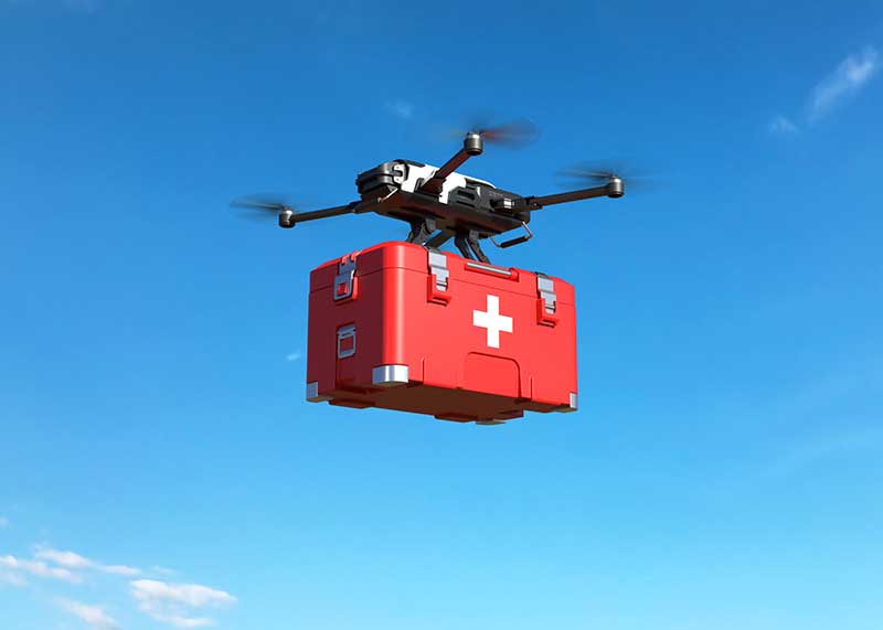
As the world goes in quarantine and social-distancing has become a necessity with COVID-19 pandemic, various measures have been taken to fulfill basic needs of humans. The medical sector is facing a lot of troubles as the number of cases has been increasing day by day and keeping up with the enough supply of necessary equipment and medicines is becoming difficult. Among various measures taken by hospitals and government, utilizing drone payloads for supplying medicines, transferring tests and specimens, and spreading disinfectants has become a new way to facilitate operations. From India to Canada and the U.S., the governments and tech firms have been developing drones that can carry loads and travel up to certain distance to speed up medical and healthcare processes. The market for drone payload is gaining momentum. According to the report published by Allied Market Research, the global drone payload market is expected to generate $7.01 billion by 2022. Following are some of the activities taking place across the world.
On the verge of COVID-19 outbreak, various measures have been taken by governments to control the spread and eliminate completely. Among the measures taken by various governments is disinfecting the cities. Bengaluru, a city from Karnataka, India has been disinfected with the help of drones. Six hexacopter drones have been deployed. They are equipped with 15 liters of disinfectants for various localities of the city. These drones have been developed by startups Alpha drones and Multiplex. It has five kilometer range and has ability to fly for 25–30 minutes based on the payload. The pre-set speed of drones is at 6 meters per second. Nearly 10–15 meters of area is covered based on the altitude. The cetrifuger automiser pump technology is utilized for spreading the disinfectant in air and on lands. Highly crowded areas such as markets, bus stops, railway stations, and others will be covered and drones will be operated for 6–7 hours each day.
Along with spreading disinfectants, there have been another medical uses. Urban drone stations have been utilized for logistic medical payload exchange in hospitals. The Matternet Station at Mountain View, California, is a structure that can be mounted on ground or rooftops. It is three meters in height and offers personal safety. Hospitals can utilize the stations for transferring pathology specimens, blood diagnostics, and medicines to other facilities and suppliers. It also offers fast, secure, and predictable aerial delivery.
Each Station is equipped with its own automated aerial deconfliction system for management of drone traffic at the Station. The Station enables Matternet M2 drones to carry out a precision landing. Then the drone is locked in the particular place and executes swapping of payload and battery. There is a Matternet Cloud that directs flight directors an ability to control and track operations. Moreover, an integrated authentication system enables only authorized personnel to insert or take out payload through scanning of hospital identification badge. Then there is a tracking of payload at each touch point for maintenance of strong custody. Ideally, it can hold four boxes of payloads that are held at the controlled temperature for maintaining integrity of specimen. Andreas Raptopoulos, CEO of Matternet, outlined that the technology platform will be utilized for rapid, point-to-point, and urban medical deliveries. This way, hospital systems are able to reduce patient waiting times and carry out savings of millions of dollars each year.
Another company has taken measures to contribute to countering the outbreak of COVID-19. Drone Delivery Canada (DDC) would bring its own drone delivery system by the mid April for delivery of blood test, blood samples, and medicines. Michael Zahra, president and CEO of DDC, outlined that it is a necessity to bring an automated and unmanned delivery system of drones to supply medical necessities to the right people at rapid pace. The company possesses the drone that can take off from the starting point, reach destination, drop the cargo and return.
Zahra have been encouraging hospitals, communities, pharmacies, healthcare centers, and others to build a case for the support from government. He added that logistics differ in each scenario, however, the basic setup can be achieved. There is a minimum required infrastructure available at the starting point. On the other hand, there is no infrastructure at the destination point.
Its Sparrow drone can carry nearly 10 pounds of payload in a single trip and can travel up to 30 kilometers. The company has a portfolio of two drones. First is Robin, which carries the payload of 25 pounds with a travelling distance capability of 35 kilometers. Another is Condor, which have capability to carry 400 pounds and go up to 200 kilometers. With the Special Flight Operations Certificate, the company’s drones can navigate throughout Canada without the need to outline flight plans regarding routes prior to trips. Once it obtains the permission and support from government to implement drones for medical purposes, it would implement its model and accelerate the supply in this grave situation the world has been facing.
Pratik Kirve holds a bachelor’s degree in Electronics and Telecommunication Engineering. He is currently a senior specialist — content writer at Allied Analytics LLP. He has avid interest in writing news articles across different verticals.
In many ways, 2020 would be another big year for commercial drones. The market has witnessed slow and steady growth over the years, and according to Allied Market Research, the global commercial drone market is expected to reach $10.73 million by 2022, growing at a CAGR of 26.2% from 2016 to 2022. This exponential growth is due to the high demand for cost-effective, energy-saving and eco-friendly OLED lighting coupled with growth in display and large screen backlit market. On the other hand, the outbreak of COVID-19 has reshaped every other industry and business function in the world and the commercial drone industry is no exception.
Use of commercial drones during COVID-19 pandemic
Even though complete ramifications of COVID-19 are not clear, some impacts of the standstill of the global economy beginning to be felt. Needless to say, the drastic changes in the drone industry are imminent and the market players would feel them over the coming years.
Search & rescue mission
Initially, several countries used commercial drones for search and rescue missions. Moreover, some countries used them spanning deserts and high population areas. As drones have the potential to visualize and communicate with complicated areas, the demand for them increased to supervise the dense and urban areas during the initial stages of the COVID-19 outbreak when panic was taking its root. Thanks to drone technology, officers could easily scan an area and broadcast necessary instruction if the area is infected while maintaining the safety of the officials.
Delivery of essentials
Since the declaration of a pandemic, the local governments have asked citizens to maintain a safe distance and limit the exposure to the virus. This greatly affected the food and package delivery systems, as it may be a potential factor of contamination. Although drone package deliveries are not used across the globe, few tests in the U.S. and the Dominican Republic have proven to effective. The use of commercial drones is encouraging as most of the commercial drones can be modified with payload drop mechanism and used for package deliveries without risking both parties. The package delivery system by drones is particularly important in areas where the presence of the virus is imminent such as hospitals that actively treat the virus.
Disinfection of public areas
The use of commercial drones is effective in disinfecting area. Even though more information about the virus is being discovered, the officials have declared that it can survive on hard surfaces such as chairs and buses. Thus, public places pose a huge risk of infection. To prevent further spread and disinfect public areas, some countries have deployed agriculture spraying drones filled with disinfectant instead of pesticides.
Apart from this, the entire country of China has implemented commercial drones to perform simple temperature check processes before admitting visitors into the building. As the major symptom of the virus is fever, the use of commercial drones to spot potential patients without compromising the safety of anyone.
Major trends in the commercial drone industry
The increase in counter-drone solutions has almost doubled in the past year and its market is expected to grow rapidly in 2020. Urban air mobility has been a buzzword since the rise of the commercial drone market. In addition, drone deliveries have already started in the U.S., Ghana and Australia. Developing countries such as China and India have actively used drones for drugs and food delivery. In the future, the development of passenger drones will demand more funding to get certified, boosting the passenger drone market.
The increased popularity of drones would press the government to review regulations regarding unmanned vehicles. In the next five years, commercial drones would enter in unmanned traffic management and remote identification.
In the coming years, the adoption of aerial drones and commercial drones are likely to enter various market apart from healthcare, agriculture, and entertainment. Instead, it will grow in industries such as insurance, public safety and first responders, and mining.
Apart from this, the advancements in imaging sensors and aerial imaging software are expected to improve artificial capabilities. Currently, the majority of the technologies applied in commercial drones include cloud-based machine learning and AI-based drones are still in the development stage. The increased adoption of drones and advancements in sensor technology and automation will open new opportunities in the coming years.
Thanks to the early hype about commercial drones and how they hold the potential to transform industries, there will be a huge investment in the market to make such forecasts in reality. Due to the COVID-19 pandemic, the adoption of commercial drones has increased. Over the last few years, there was public distrust in the technology. However, the benefits of use of drones during pandemic have reduced some concerns about commercial drones. In addition, new governmental regulations regarding the use of unmanned vehicles clear the misunderstandings and concerns about drones with safety and privacy. However, one thing is sure, despite the tragic start of the new decade, the COVID-19 pandemic has been favorable for the commercial drone market and is expected to bring opportunities in the future.
Swamini Kulkarni holds a medical bachelor’s degree from Pune University, and works as a content writer exploring the impact of technology on human life.
“For decades, the unmanned systems industry has reshaped critical missions and business operations by meeting challenges head-on with innovation and resolve,” said Brian Wynne, president and CEO of AUVSI. “Our commitment to supporting the unmanned systems community remains unwavering, so amidst the current global health crisis we, too, must adapt to fulfill that mission.”
Xponential 2020 was originally scheduled to take place May 4-7 at the Boston Convention and Exhibition Center. It was then rescheduled to take place Oct. 5-8 at the Kay Bailey Hutchison Convention Center in Dallas.
“While we are disappointed to not be convening in person this year, the health and safety of Xponential exhibitors and attendees is our utmost priority,” Wynne said. “It may not look like the Xponential we are used to, but we look forward to offering attendees the opportunity to virtually network, learn from and collaborate with one another just as they have in years past.”
According to AUVSI, those who have already registered for Xponential will receive an email in the coming weeks to confirm options for participation in the virtual event.