GPS World, a business-to-business (B2B) media brand, was honored with a 2021 Azbee Award of Excellence from the American Society of Business Publication Editors (ASBPE). GPS World is published by North Coast Media, based in Cleveland, Ohio. Other NCM brands taking home awards were Pest Management Professional and Golfdom.
GPS World received a regional bronze award for its online and social media coverage of how COVID-19 affected the GPS and GNSS industry throughout 2020. Our COVID-19 coverage can be seen here.
Azbee Awards recognize the exceptional work of print and digital media in the professional publications industry. One of the most competitive award programs for trade media, the Azbees highlight editorial and design excellence in magazines, and digital and social media. More than 800 entries were submitted for this year’s Azbee Awards.
“Year in and year out, our print and digital media are selected as content and design leaders,” said Kevin Stoltman, NCM president and CEO. “This is great news for our marketing partners. Our brands continue to be the most trusted in their respective industries because our print and digital content, and highly engaged audiences of qualified buyers, are unparalleled.”
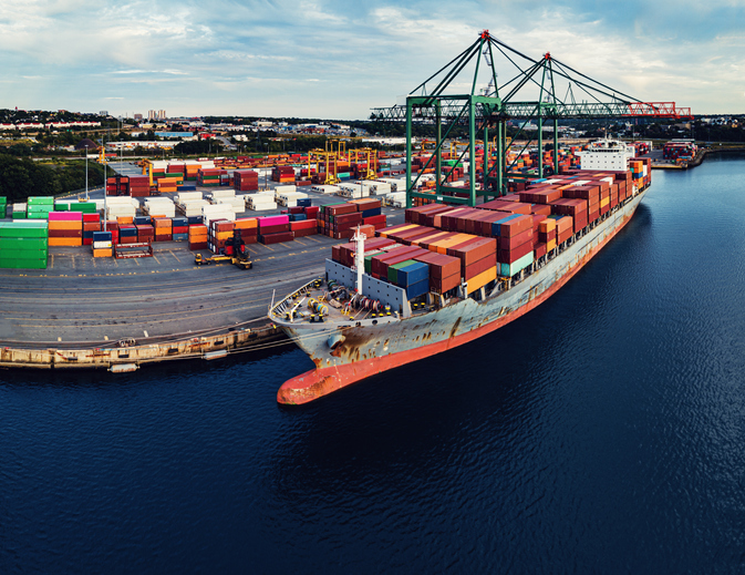
Geospatial data is key to logistics, including for the huge increase in e-commerce we are experiencing following the 2020 COVID-19 shutdown.
The best customer service is if the customer doesn’t need to call you, doesn’t need to talk to you. It just works. — Jeff Bezos
This past year has been a boon for the e-commerce industry. It increased from 4% of retail sales a decade ago and pushed past 20% in 2020, reaching nearly $800 billion — a 32% jump in 10 years.
Online businesses climbed to all-time highs. A few examples stand out. Amazon’s stock increased in value 83% over the course of last year. That type of growth happens with startups and small-cap companies but is usually unheard of with large blue-chip stocks.
Along with Amazon’s growth last year, FedEx had $69 billion in annual sales. DoorDash, an e-commerce food delivery company, has a market valuation of $45 billion, making it larger than Domino’s Pizza, Texas Roadhouse and Yum! Brands combined; and Yum! Brands owns KFC, Pizza Hut and Taco Bell.
The e-commerce global trend in online sales is expected to reach $4.9 trillion in four years based on only 2.14 billion online shoppers. That is less than one-third of the world’s population. There is a lot more room to grow. This past year moved the trend several years forward.
Where are all those goods stored?
Photo: Navy Petty Officer 2nd Class Jasen Moreno-Garcia/U.S. Navy
Each consumer requires an average logistics space of 35 square feet. In the United States alone, there are more than nine billion square feet of warehouse space, and when online sales increase another 10% it will require 3 to 4 billion square feet more of space to keep up with demand.
The increase in freight driven by this trend is captured in the chart below published by the Federal Reserve, with data provided by the U.S. Department of Transportation. The blue line is increasing freight transportation services, while the red line indicates on-hand inventories.
As transportation increases and becomes more reliable — a reflection of the overall health of the logistics supply chain — the amount of on-hand inventory decreases, allowing sellers to free up space and save money, or offer greater variety knowing that stocks can readily be backfilled.
However, when inventories get too low, the system is subject to severe supply shocks, making prices more sensitive to the law of supply and demand. The grey-shaded areas on the chart are economic downturns officially recognized as recessions.
If delivery took six-to-eight weeks these days, it would signal a crisis somewhere in the world.
21st-century logistics
Goods from global corporations now arrive at each customer’s doorstep. This is 21st-century logistics. Home delivery in two days or less is the expectation. The compression of time in this industry is astounding when compared to “the way things used to be.” The way things are compared to the way things used to be reminds me of hearing my grandparents talk about life before automobiles.
Back in my day, ordering from a catalog required calling the company and speaking to a representative. The call had to be made from a corded landline, and long-distance charges might apply. If ordering a gift for someone in the household, it was difficult to be clandestine with everyone nearby. The other option was to mail in an order form. Either way, delivery took a minimum of six to eight weeks, and sometimes more. If delivery took that long these days, it would signal a crisis somewhere in the world.
Knowing where to pre-position supplies ahead of anticipated demand is a geospatial problem. Most think of this in terms of sales to customers and deliveries ahead of seasonal demands, but many countries in the world are facing this dilemma right now figuring out the best way to distribute COVID-19 vaccines. That challenge is taking place in your own community and has been a long-standing public health challenge.
Beginning in the mid-2000s, geospatial information systems (GIS) were brought in to help control outbreaks of the deadly Ebola virus. In 2014, I took a Penn State geospatial intelligence course. The final exam addressed the geospatial challenges of fighting an epidemic. Theoretically, it was difficult to get the required goods to the right place at the right time. But now, it’s not an exercise, and getting it right is not an option.
If you have received the COVID-19 vaccine, you can appreciate the pharmaceutical industry for developing vaccines in record time. However, getting the vaccines to everyone is a logistics challenge, and GIS is the unsung hero. Logistics is the life blood of empires — it is the game of kings and generals. With it, wars are won and commonwealths prosper; without it, empires crumble to dust.
How Geospatial Data Guides the Goods
Back to the traditional understanding of supply chains from seller to buyer. The needs of the buyer are simple: faster, better, cheaper. For the seller, it is much more complex, and considerations deal heavily with location.
Where is the best place to have a distribution center?
Is it more important to be close to a multi-modal transfer station, or to population centers, or are land prices more important?
What about access to highways?
What are the trade-offs in delivery times being further away from the population?
Is the trade-off worth it for the cost of land and lower taxes?
Geospatial data can answer all of these questions, even going so far as to run “what-if” scenarios.
At the local level, transportation logistics schedules the most efficient routing to deliver more packages along the shortest path. This saves time and fuel, as shown in the image below using Maptitude software. Radiuses can also be calculated based on drive times instead of distances.
Caliper truck routing software can be used for planning deliveries that account for vehicle capacities, time windows, multiple depots and more. (Image: Caliper)
Navigation routing applications are dynamic, and pick-ups are automatically routed to drivers while out on delivery runs. Dynamic routing avoids delays such as accidents and road closures.
This same type of technology is used for emergency services to respond to a call. Ambulances, police and fire trucks all use dynamic routing to get to distress calls as soon as possible.
Global transportation logistics also need to account for international laws and regulations as cargo passes through each country. These regulations can be onerous, but the logistics industry has worked out the legalities to ensure a seamless, uninterrupted flow from ship to train to airplane to truck and to final delivery. It is symbolized by the universal 40-foot international shipping container standardized throughout the world.
At each facility, inventories are tracked. Each item passing through receives a time and location stamp. Estimated delivery times are sent via text message to your mobile device or email. When the item is out for delivery, it is possible to watch it on a map as the delivery truck makes its way towards your location. When the item is delivered to your doorstep, a picture of it is sent to your phone with an alert that the package was delivered.
Only a few days earlier, the manufacturer — perhaps on the other side of the world — placed the item in a box and taped it shut; even though you ordered it in your language, the order received by the manufacturer was in their language. The package started its journey to you at the next scheduled pickup, maybe within an hour of you placing the order. Shortly afterward, your order was on a ship or an airplane. As you went about your usual business, the incredibly efficient system of e-commerce sped your package around the world to deliver it to your doorstep.
Logistics has undergone a revolution built upon the most advanced technological innovations: robotics, artificial intelligence, machine learning, mobile devices, cloud computing, electronic payment processing, and a vast geospatial framework.
In fact, it is a continuously operating, seamless, geospatial mesh running on a global scale across all time zones that allows the industry to function. Every aspect of the logistics supply chain relies upon GIS in some way, from land, air and sea navigation from global location-based systems down to inside a warehouse for storage and retrieval of merchandise. Modern-day logistics is a geospatial industry connecting goods and services to consumers, putting the GIS in lo-gis-tics.
Image: U.S. DOT
Can GIS predict the future?
Regarding whether GIS can predict a market correction… I’ll not make a prediction, but the Transportation Services Index (TSI) for March is due to be released today, May 12. If it is down from February, it would mean two months of back-to-back decline. April’s numbers won’t come out until June. However, here is an indicator of where things currently stand. The ports of Long Beach and Los Angeles, CA, the largest shipping ports in the United States is five days behind schedule, which is down from over 10 days in January.
The TSI is a leading indicator of the economy. When 20% of sales are online in a consumer-based economy, the wellbeing of the commonwealth is measured one delivery at a time.
“Trade isn’t about goods. Trade is about information. Goods sit in the warehouse until information moves them.” — C. J. Cherr
William Tewelow
William Tewelow works for the Federal Aviation Administration. He is a graduate of the FAA management fellowship program. He served on special assignment to the U.S. Department of Transportation leading a national strategic geospatial initiative for the White House Open Data Partnership. He is a Geographic Information Systems Professional (GISP) and a speaker for the Maryland STEMnet Scholar program.
He was among the first in the nation to earn a Geospatial Specialist Certification from the U.S. Department of Labor while working at NASA Stennis Space Center. He has degrees in Geographic Information Technology, Intelligence Studies, and is completing a masters degree in Organizational Management.
William is a 23 year veteran for the U.S. Navy serving as a Geospatial Specialist, Imagery Intelligence Specialist, a Naval Aviator, a Meteorologist, and a Tactical Oceanographer. He is married, enjoys writing and traveling.
His favorite quote is, “A man’s mind changed by a new idea can never go back to its original dimension.” — Oliver Wendell Holmes
“Seen & Heard” is a monthly feature of GPS World magazine, traveling the world to capture interesting and unusual news stories involving the GNSS/PNT industry.
Screenshot: PATS Indoor Drone Solutions video
Seeking out (tiny) aerial threats
Palm-sized drones are eliminating greenhouse pests in the Netherlands, reports the Associated Press. The drones seek out and destroy moths that produce crop-eating caterpillars. Tech startup PATS Indoor Drone Solutions uses drones as greenhouse sentinels. Cameras scan the airspace, and then steer the drones to fly into moths, destroying them in midair. The drone control system can distinguish between good and bad insects. The system is the brainchild of former students from the Delft University of Technology.
Photo: Skydio
Coming soon to a police department near you
Drone-maker Skydio claims to be shipping the most advanced artificial intelligence-powered drone ever built, reports Forbes. The Skydio X2 is scheduled to launch later this year. The quadcopter reportedly can latch onto targets and follow them, dodging all sorts of obstacles and capturing everything on high-quality video. It can fly in tight, tactical situations, such as inside buildings or through a forest. Skydio claims its software can even predict a target’s next move, whether pedestrian or vehicle. American-made, the Skydio is popular with police departments and is often used for defense.
The Loyal Wingman in its first test flight. (Photo: U.S. Air Force 88th Air Wing Public Affairs)
Fighter jets to get a sidekick
A military drone that will accompany fighter jets into combat flew its maiden voyage at the end of February. The Loyal Wingman, designed by Boeing Australia for the Royal Australian Air Force (RAAF), uses artificial intelligence to target enemies. The Loyal Wingman is about the same size as the F-35 jet it will fly alongside. It has a range of 3,700 kilometers. The plane was flown from the ground control station at the Woomera Range Complex in the outback. The RAAF plans to buy three of the drones.
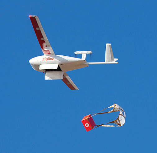
Photo: Zipline
COVID-19 vaccinations air-dropped in Ghana
Ghana has launched a nationwide program that uses Zipline drones to deliver coronavirus vaccines to rural communities. Deliveries began March 2 under the COVAX program of the World Health Organization (WHO), which aims to provide poorer countries with enough doses to cover 20% of their populations. Zipline has been delivering medical supplies (blood, personal protective equipment, vaccines) since 2016 using its patented, autonomous drones.
A major geospatial conference encompassing previous annual conferences is scheduled for 2022.
The AEC Next Technology Expo & Conference, International Lidar Mapping Forum and SPAR 3D Expo & Conference will unite as one show. The new Geo Week show will also encompass partners U.S. Institute of Building Documentation (USIBD) and American Society for Photogrammetry and Remote Sensing (ASPRS).
Geo Week, which takes place Feb. 6-8, 2022, in Denver, will bring together the best of 3D technology for the built world, geospatial applications and more. The joining of the events reflects the increased integration between the built environment, advanced airborne/terrestrial technologies and commercial 3D technologies, according to organizers.
Geo Week will provide education, technology and resources for professionals in industries including AEC (architecture, engineering and construction), asset and facility management, disaster and emergency response, Earth observation and satellite applications, energy and utilities, infrastructure and transportation, land and natural resource management, mining and aggregates, surveying and mapping, and urban planning/smart cities.
“We’ve witnessed the growing convergence between geospatial and the built world, and we received positive feedback from customers about holding the events together, which had been the plan for 2020 and 2021 before the pandemic forced us to cancel due to the unavoidable consequence of the worsening magnitude of the public health and safety issues caused by the COVID-19,” said Lee Corkhill, marketing director at Diversified Communications.
“We believe the market is ready and eager for this next step of leveraging the confluence of what are becoming ubiquitous technologies for improved collaboration, increased efficiency, and better outcomes,” Corkhill continued. “Much of the conference content and technology being showcased will reflect and support this increasing integration.”
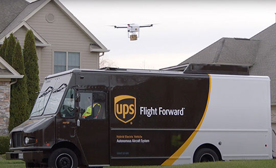
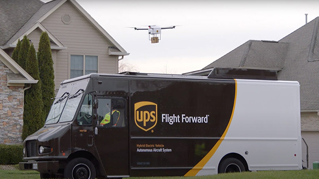
Skyward, a Verizon company, and UPS Flight Forward will collaborate to deliver retail products with drones connected to Verizon 4G LTE, as well as testing and integrating 5G for delivery.
“We will need the ability to manage and support multiple drones, flying simultaneously, dispatched from a centralized location, operating in a secure and safe environment,” said Carol B. Tomé, CEO of UPS. “To do this at scale, alongside Verizon and Skyward, we’ll need the power of 5G.”
“We’re just beginning to see how the power of 5G Ultra Wideband will transform the way businesses operate,” said Rima Qureshi, chief strategy officer at Verizon. “By partnering with UPS and other innovative companies, we can learn from each other’s expertise and collaborate to create solutions that help move the world forward.”
Photo: Verizon
In 2020, Verizon, UPS Flight Forward and Skyward started testing 4G LTE in delivery drones to demonstrate cellular reliability and performance at altitude.
“The low latency of 5G and edge compute is ideal for monitoring air traffic in and out of a busy logistics hub, especially those using mixed fleets of autonomous vehicles like drones, trucks and planes,” said Mariah Scott, Skyward President. “This year, we’ll be taking the collaboration with UPS further by testing 5G Ultra Wideband integrations to connect the sky.”
UPS has operated more than 3,800 successful drone delivery flights since the creation of UPS Flight Forward, its drone delivery company, certified by the Federal Aviation Administration in 2019. But in 2020, drone delivery emerged as much more than rapid delivery of essential healthcare items — during the global pandemic it provided high-risk seniors a rapid and contactless delivery option to remain healthy at home.
“Using Verizon’s 5G and Skyward, we’ll be able to transform the delivery experience — more personal, more on-demand and with the same safety, efficiency and reliability our customers trust today,” said Bala Ganesh, vice president, Advanced Technology Group at UPS.
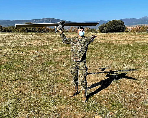
The Spanish Army and Navy have received the first Seeker Remotely Piloted Aircraft Systems (RPAS) from GMV and Aurea Avionics. The unmanned aircraft is designed to boost the intelligence, surveillance and reconnaissance capabilities of two elite forces, the Spanish Army’s 6th Almogávares Paratroopers Brigade and the Marine Infantry Protection Force.
Seeker has a 90-minute endurance and 15-km range, and weighs 3.5 kg. The UAV’s design and manufacture in Spain proved crucial during the COVID-19 epidemic, with the manufacture, test flights and delivery of the aircraft all performed within the project deadlines.
In the final phase of the project, intensive training courses took place on the Madrid site of Aurea Avionics and the Los Alijares Firing and Maneuvering Range (CMT) of Toledo. There, future Seeker users put the RPAS through its paces with mission simulations, engaged in vehicle-tracking exercises and learned about its theoretical and practical uses.
Seeker will provide BRIPAC (Paratrooper Brigade) and BRIMAR (Marine Infantry Brigade) with real-time thermal-infrared and visible-spectrum video, augmented by metadata that can be mined by the operators and remotely by the command-and-control centers.
New digitized ground-station architecture makes Seeker compatible with NATO’s standard command centers. This means any allied force will be able to integrate the aircraft into its fleet and command centers, ensuring joint operability between all troops and systems.
The RPAS is financed by the Subdirectorate General of Planning, Technology and Innovation of the Directorate General of Armaments and Material.
If there were ever a time to sit back and reflect on things that have happened in the last calendar year, the year 2020 will be the poster child for the next few generations (at least I hope so…). Because of several things that have happened worldwide in the profession of surveying, let us take this opportunity to look back on a year that was filled with new equipment, emerging technology and government interaction that will have a lasting effect on our surveying horizon.
Look at all of these wonderful toys
There was no shortage of introductions to new equipment for surveyors, especially in the GNSS receiver market. While combining GNSS capability with an inertial measurement unit (IMU) is not a new concept, the Big Three of Leica, Topcon and Trimble introduced new or upgraded versions of their latest receivers taking full advantage of the technology. The benefit of having the IMU integrated within the receiver is the ability to “tilt” the instrument yet having the calculated position remain at the tip of the receiver pole.
Photo: Trimble
Leica, however, takes the tilting feature to another level with an integrated camera that allows for close-range photographs to capture additional information through remote sensing software. The data extracted from the photographs can be simple points (and verified in the data collector while in the field) or point clouds that can be integrated into larger projects through the Leica office software.
These new receivers, along with upgraded models from smaller providers, have opened the GNSS market to many more users well beyond surveying. The combination of more capability through advancing satellite constellations, more robust processors, and reduced receiver sizes have continued to drive GNSS positioning growth.
Photo: Hexagon
Manufacturers are using these increased capabilities to promote better coverage to obtain positions under heavier canopies and less likelihood for multi-path errors. While I remain cautious about these claims of increased coverage, I also maintain that with any tool, measurements and positions must have proper and appropriate validation. However, I am impressed that the technology continues to advance with what was once seen as only applicable to the open sky.
Not all the new technology has emerged through the GNSS receiver product lines; several less visible but valuable features have been introduced within the robotic total station lines. The manufacturers continue to push their equipment to react faster, stay locked on targets better, and provide more reliable solutions to data collection and construction layout. Data collectors continue to evolve with larger screens and more software capability, with some rivaling their desktop counterparts.
As cellular networks grow in both size and speed, more direct connections between field and office are being made with faster response time to data transfer. Data collection can take place in the field and be analyzed by an office technician as it happens. Go another step further and add an aerial background image to the collector and/or the office computer; now each team member can confirm that the information being collected is sufficient for the project in real-time.
Another technology that continues to advance is remote sensing, with more devices being introduced and with increased software capabilities. Besides new and upgraded offerings from the surveying-based manufacturers, other device makers are introducing products that offer remote sensing to the masses. The biggest news in this arena was the announcement from Apple that the iPhone 12 Pro and iPad Pro would come equipped with lidar sensing technology along with incredible photographic capabilities.
While there does not seem to be specific apps developed for surveyors at press time, it is safe to say that there will be in short order. It is also a safe bet that having this capability on a mass-produced device will put pressure on the surveying and mapping equipment manufacturers to be cost-competitive on their own proprietary devices or risk losing out on market share.
UAVs continue to be the fastest-growing segment of the surveying industry. More vehicle, sensor and software providers are coming to market to offer the surveyor a variety of choices. DJI continues to lead the way in the multi-rotor category with new products and sensors while other manufacturers are embracing the fixed-wing and vertical take-off and landing (VTOL) platform for greater range.
Just like their automobile brethren, flight time continues to increase with discoveries of new battery compositions and weight considerations. The sensor market is expanding to include more affordable lidar units, as well as new technology in multispectral identification, gas and noxious odor detection, and much more.
Software developers, too, continue to refine and expand the features found in their geospatial offerings with advancing technology and programming. Google Maps is the default navigation app for many smartphone users, but like anything utilizing GNSS in dense urban areas, the users find themselves bouncing all over the map.
2020 did not see any shortage of government action for the surveying and mapping community. As with many topics that come out of the nation’s capital, it should not surprise anyone that several of the items considered by the federal government and its agencies were not without controversy.
The biggest and most controversial item continues to be the advancement of Ligado (formerly known as LightSquared) and the development of new communication technology that has been shown to interfere with the GPS transmission bands. The Federal Communications Commission (FCC), led by Chairman Ajit V. Pai, has been successful in holding off all challenges to the new technology including ones from current legislators and defense staff.
The main argument from the FCC is the value of the system as a provider of 5G communication to a substantial portion of the country. They also make statements that safeguards are being taken to protect the GPS spectrum, yet many studies from outside parties show otherwise. The fight over this spectrum will continue into 2021, and it will be interesting to see if the new administration will see things from a different perspective.
Several items to come out of Washington, D.C., late in the year were the blacklisting of DJI and the announcement of new UAV rules for flying over crowds and at night. With the DJI ruling, it is now illegal for government agencies to use the Chinese-based UAV maker for any activities. Based upon the significant market share of DJI, one can only wait to see how this situation plays out, and if the ban is expanded to private individuals.
The FAA announcement on the new UAV flight rules was surprising but not unexpected. In addition to establishing flight limitations over crowds and at night, it also established a timeframe for requiring most UAVs to transmit a Remote ID during flight for determining who is flying and where they are located. Compliance with these rules will be required by the manufacturer within 18 months and by UAV pilots within 30 months.
The National Geodetic Survey (NGS) has also been busy during 2020 preparing new datums and specifications for upcoming changes to the National Spatial Reference System (NSRS). Among those changes are the deprecation of the U.S. Survey Foot, beta testing of the latest geoid model (GEOID20), and new software tools for transforming positional information between datums. It was also announced that the release of the modernized NSRS scheduled for 2022 was being delayed.
NGS continues to work with each state on the improved state plane coordinate systems and/or low distortion projection systems that will be implemented with the new NSRS rollout. All these efforts have been a monumental task (no pun intended) and kudos go out to NGS for getting everything this far.
Pandemic 2020 (No, this is not a movie or a drill)
As we covered in the May 2020 Survey Scene article, COVID-19 was unlike anything we had been exposed before. Initial reports tried to relate the virus to typical influenza and the H1N1 outbreak in 2009, but the rapid transmission and sheer volume of cases (and deaths) mostly eliminated those comparisons.
From a technical viewpoint, the situation with COVID-19 has no bearing on GNSS operations and positional establishment. An operator of a GNSS receiver, and the business of surveying, is greatly affected by the presence of COVID-19 so it does deserve more than a brief mention in a retrospective look at the past year. This virus upended everything; from data collection and survey-related activities to computations and final drafting, the business of surveying felt the effects.
Once the initial challenges of keeping everyone safe were addressed, it became a year-long marathon of providing surveying services to clients that did not let the pandemic hinder their progress. Field crews were under significant pressure to maintain social distancing at every turn, while office staff dealt with home Wi-Fi and lack of access to normal business conditions such as large-format printing.
Video calls and instant messaging quickly became the norm, yet also became the scourge of dealing with the day-to-day operations of a business. The “normal” work/life balance with families, school, and social activities has disappeared and a more challenging approach has replaced that balance. Fingers are crossed that people will adhere to social distancing protocols and can get vaccinated as soon as possible so we can resume a portion of our previous lifestyles.
However, we do have several positive things to take away from the challenges of the pandemic that will make our lives better going forward. Our reliance on geolocation became quite clear throughout the pandemic. Whether it is using it to help establish contact tracing or as simple as having a delivery service bring necessities straight to your door, almost everyone relies on geolocation for helping guide them through the “new normal.”
We are using our smartphones to track our family members and help keep them out of harm’s way. It would be hard to imagine how much more difficult this situation would have been before cellphone and GNSS integration.
Graphic: World Health Organization (https://www.who.int/emergencies/diseases/novel-coronavirus-2019).
Another leap forward that most people are not aware of is the publicizing of GIS dashboards and incredible analysis of the geolocation of people worldwide. While GIS dashboards have been in existence for many years, it is only now that the public has paid attention to the vast information available to them.
From providing numbers of cases to graphically depicting “hotspots” across the world, these dashboards are full of useful information to help people understand the size of this pandemic, the places where mitigation is working, and where additional restrictions are being put in place to help reduce the spread of COVID-19.
The ability to merge geolocations with physical conditions and situations into a real-time mapping solution can help reduce the spread of the virus. By combining GNSS technology with advanced computing power and data storage, the power of GIS has been brought to the front page of public agencies and news sites.
While we still enjoy watching movies with superheroes, the true heroes during this pandemic are the frontline health workers, first responders and data analysts/programmers who bring us this timely information quickly. A hearty thank you goes out to all of them for their efforts and dedication to the cause.
In memoriam
Photo: GPS World staff
The year 2020 also brought losses to every corner of the world and the surveying community was not spared. There are very few individuals we call pioneers in the surveying industry, so to include Dr. Javad Ashjaee among that group is no small feat. His contributions to the surveying profession helped turn every practitioner into a geospatial information provider.
From his early days at Trimble pioneering the commercial-grade receiver to creating his company at Ashtech and embracing GLONASS with GPS, he continued to expand the capability of the GNSS receiver. Many surveyors today only know his name through his latest company, Javad GNSS, and the unique line of receivers and measuring devices and their distinctive green color.
Cover photo: Ed Koziarski
Dr. Ashjaee was a big part of the GNSS revolution, so next time you starts up their receiver to collect survey data, take a moment to thank him. It was my pleasure to meet and interview him at the 2017 Intergeo trade show in Berlin to talk about his product line. I was also able to test-drive his incredible GNSS products for a feature in GPS World magazine on using smartphones for data collectors.
To say the man will be missed is a big understatement and I wish his family well on continuing his company and tradition of making great leaps in technology.
The IGS Workshop, scheduled for September 2021 by the International GNSS Service (IGS), has been postponed to 2022. The IGS Central Bureau voted for the postponement in December during its governing board meeting.
The IGS Workshop, originally intended to take place 2020, was postponed to 2021 because of travel restrictions associated with COVID-19. The dates of the workshop will be determined later.
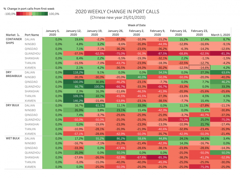
Movement, closeness, privacy — many things we took for granted a few months ago have become luxuries after the onset of COVID-19. To get an understanding of the scale and impact of the virus, we can look at global movement trends of people and merchandise using GNSS technology.
Marine
Before the coronavirus pandemic, globalization seemed to be increasing endlessly. Now, we face new trade restrictions, protectionist policies, and a global economic downturn that threatens to stunt growth for years to come.
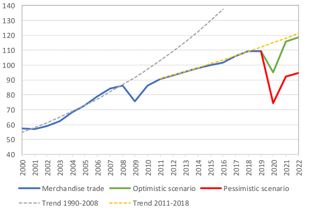
In April, the World Trade Organization (WTO) forecast that global trade would fall by between 13% and 32% in 2020, surpassing the “great trade collapse” of 2009 spurred by the global financial crisis.
However, the situation isn’t completely bleak. According to a recent Tradeshift report, global trade decreased by 14.8% in the second quarter of 2020, putting us on the optimistic end of the WTO estimate. June saw a rise in trade activity, suggesting that we may be recovering from the initial effects of the pandemic.
Cargo vessels, tankers, tugs, and other kinds of commercial ships are equipped with satellite navigation devices that can receive information from GNSS satellites to compute precise location and time. Maritime tracking insights obtained via GNSS/GPS signals are a great method for measuring the impact of the coronavirus on trade.
Photo: shaunl/E+/Getty Images
GPS data from MarineTraffic shows that ship arrivals decreased in nearly all of China’s ports from January to March.
Source: MarineTraffic
Just as trade shipping began to pick up in China, the United States and Europe were hit hard by the pandemic. However, shipments have now begun to climb worldwide to compensate for cancellations earlier this year.
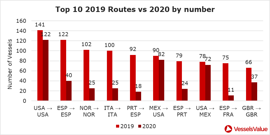
The cruise industry, on the other hand, shows little indication of recovery. Cruises were the fastest growing segment of the travel industry over the past five years — until the pandemic hit.
On June 19, the Cruise Line International Association (CLIA) and Centers for Disease Control and Prevention (CDC) announced a “no sail order” for cruise ships. The order has been extended through Sept. 30. Furthermore, the cruise industry’s reputation has been damaged by multiple outbreaks on ships, most recently the MS Roald Amundsen of Norway. At least 43 people were infected on the MS Roald Amundsen, and Norway has now banned cruise ships with more than 100 passengers from disembarking at Norwegian ports.
Maritime intelligence company VesselsValue is using AIS data to map cruise ship activity throughout the pandemic. They have noted that while cruise ships typically sail at 13.5 knots to 15 knots, average speed has dropped to 11 knots in 2020 as ships attempt to lower fuel costs. Port-to-port sailings have declined for the 10 most popular cruise routes.
Source: VesselsValueSource: VesselsValue
Most of the port-to-port sailings that constitute the 2020 columns in the above graph actually represent ships being repositioned for a break in service, also called a “layup.” Layups can cost cruise companies millions of dollars per month, but with no sail orders and port closures, they are a necessary expense.
According to the Oxford COVID-19 Government Response Tracker, a real-time monitoring system that evaluates government policies, April marked the strictest lockdown measures across all 133 available coastal countries. The tracker uses a stringency index between 0 and 100 based on national containment and closure policies.
Source: Oxford COVID-19 Government Response Tracker
Air
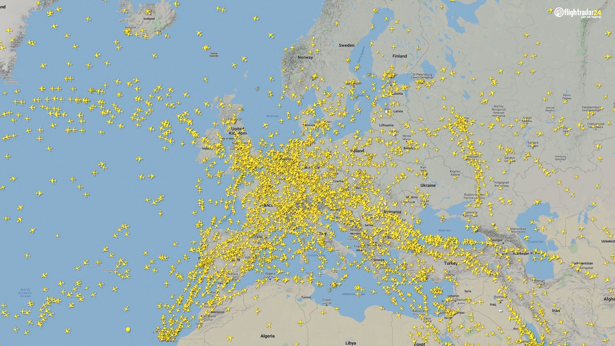
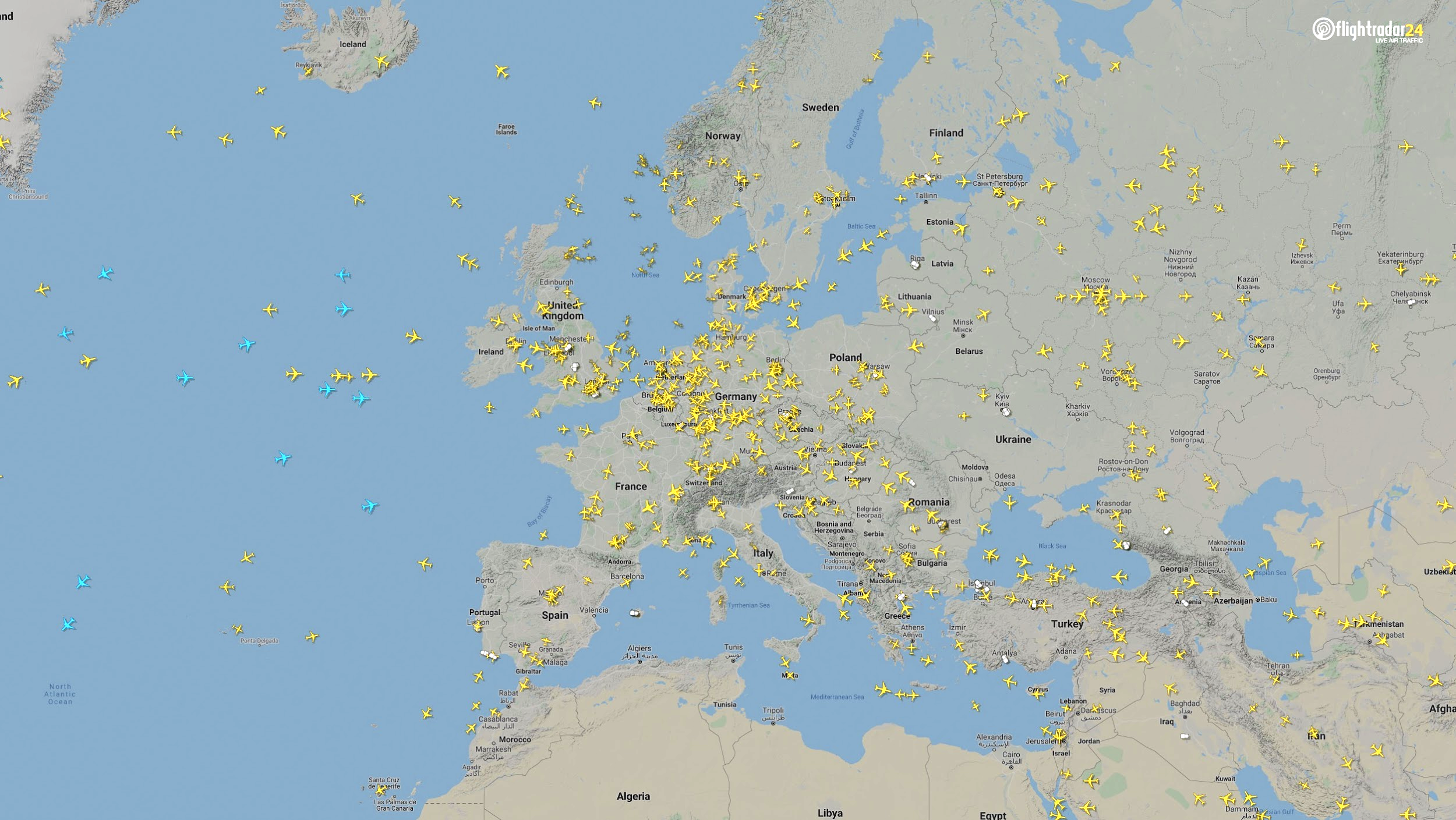
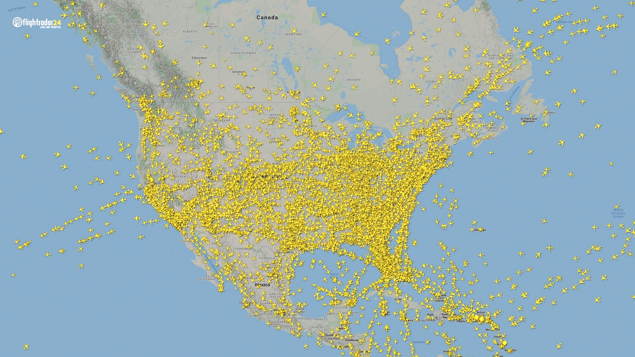
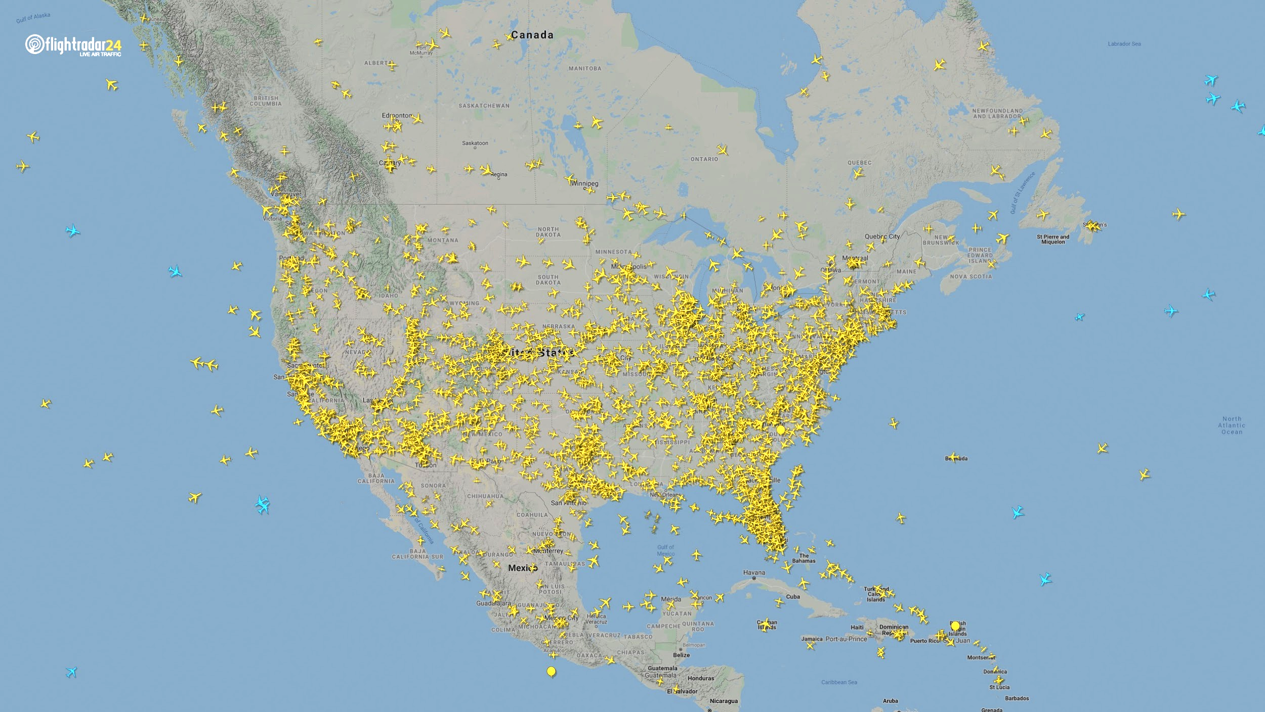
Commercial air traffic has decreased as well. According to GPS flight tracking service Flightradar24, the number of global daily flights was slashed by nearly two thirds between March and April. While there were 15,012 flights in the air at 15:00 UTC on March 7, there were only 5,275 at the same time on April 7.
Global air traffic March 7, 2020. (Source: Flightradar24)Global air traffic April 7, 2020. (Source: Flightradar24)
There were 55% fewer flights in the last week of March 2020 than in the last week of March 2019. While all types of air traffic have been reduced for fears of infection, the coronavirus has especially decimated demand for passenger flights. Passenger airlines across the world have canceled flights and cut capacity for the foreseeable future. Some passenger airlines have even switched to transporting cargo in a desperate attempt to avoid bankruptcy.
Looking at regional tracking data can further illuminate the impact of COVID-19 on air travel. Travel restrictions and border closures were enacted en masse in late March, though some nations adopted more stringent policies than others.
Europe
The number of flights in Europe has plummeted since the onset of the coronavirus pandemic. There were 2,400 fewer flights in Europe on April 7 than March 7.
Air traffic over Europe March 7, 2020. (Source: Flightradar24)Air traffic over Europe April 7, 2020. (Source: Flightradar24)
North America
Though air travel has been disrupted across North America, the United States remains significantly more busy than its neighbors. The March 7 image shows 8,400 flights while the April 7 image shows 2,950 flights, most of them concentrated over the United States.
Air traffic over North America March 7, 2020. (Source: Flightradar24)Air traffic over North America April 7, 2020. (Source: Flightradar24)
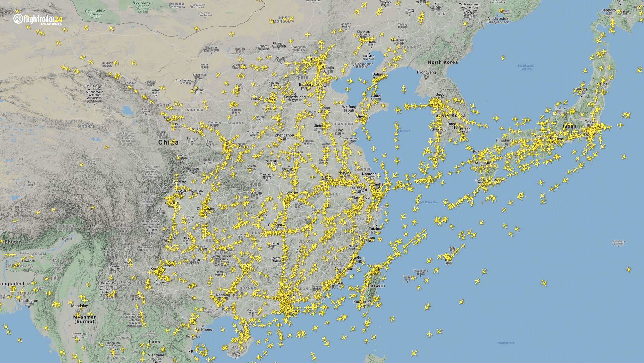
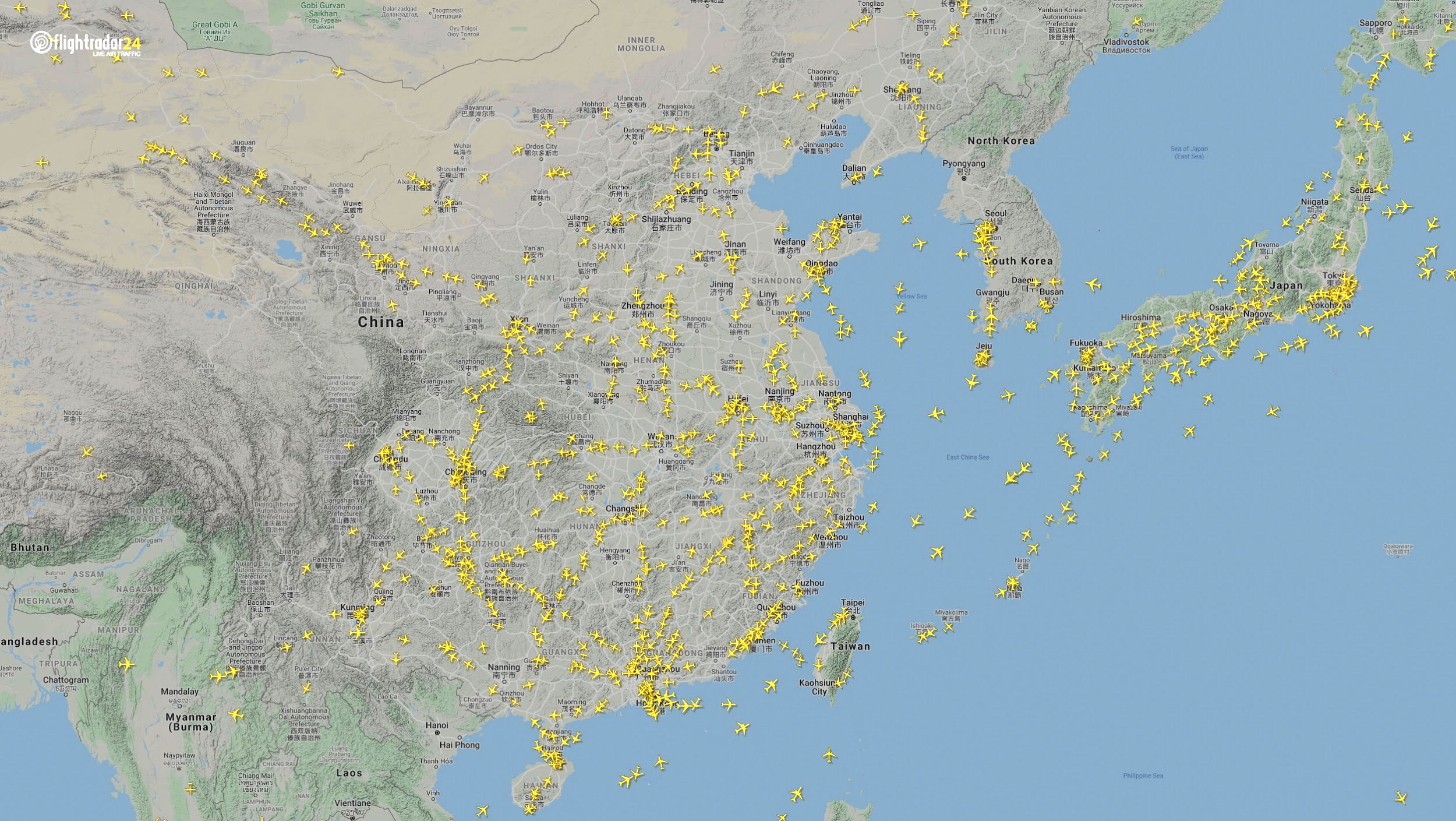
East Asia
The decrease in air traffic over East Asia has been severe and persistent. Since China and its neighbors began to experience a trade downturn as early as the third week of January, we can compare January 7 to April 7 to capture the effects of the coronavirus. As of late July, air traffic at China’s busiest airports was still down approximately 60% from normal levels.
Air traffic over East Asia January 7. (Source: Flightradar24)Air traffic over East Asia April 7. (Source: Flightradar24)
Ground
Google has released — and continues to update — a series of community mobility reports that chart movement trends in public spaces. The reports are a compilation of GPS data for Google users across the world.
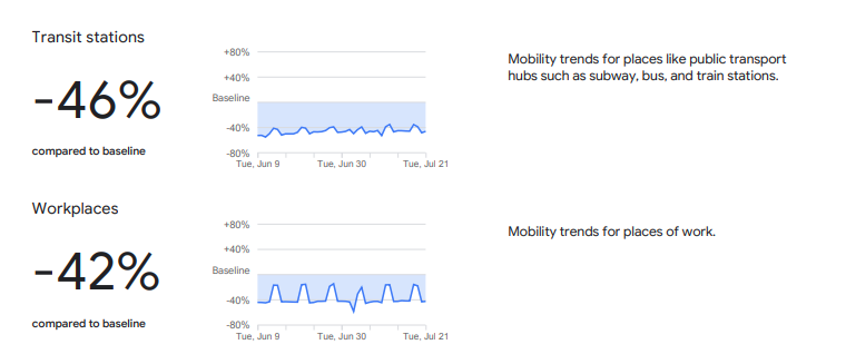
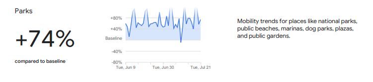
Mobility changes are particularly stark for regions hit hard by the coronavirus. New York state showed a 46% reduction in visits to transit stations and a 42% reduction in visits to workplaces in June and July compared to pre-pandemic baseline levels. New Yorkers are also visiting parks 74% more often.
Screenshot: GoogleScreenshot: Google
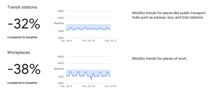
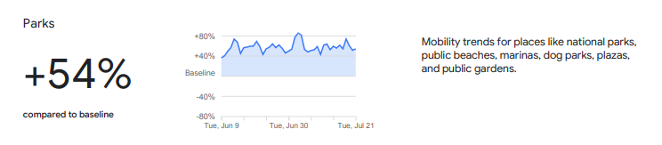
Trends in the United States as a whole are also dramatic.
Screenshot: GoogleScreenshot: Google
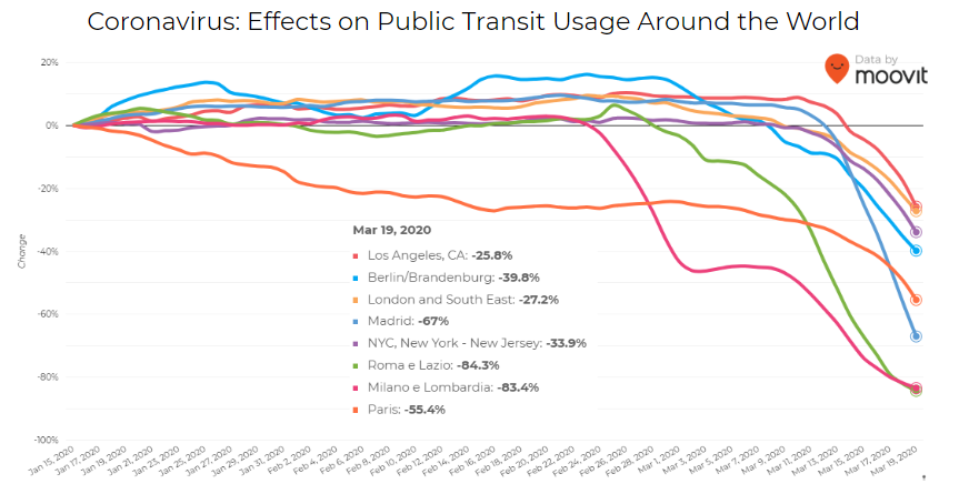
Israeli journey-planning app Moovit is using mobile phone data to document trends in public transit ridership. Many of the world’s largest metropolitan cities experienced a steep decline in ridership between mid-January and late March. Millions of people that rely on mass transit have had to cope with cumbersome rules and the danger of catching the virus itself. Efforts to reduce overcrowding on trains and buses have translated into reduced capacity requirements and therefore, lengthy wait times. The rise of remote work has also lowered public transit ridership.
Screenshot: Moovit
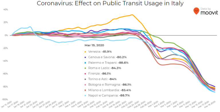
Italy was hit particularly hard – and early – by the pandemic. Two large outbreaks occurred in Northern Italy in late February, prompting widespread closures and government-mandated quarantines in Lombardy and 14 neighboring provinces. Public transit ridership plummeted when the quarantine took effect in early March.
Screenshot: Moovit
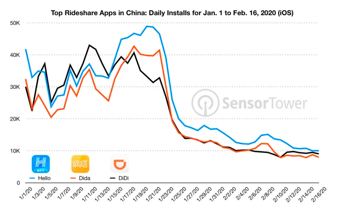
Usage of GPS-reliant ride-hailing apps has also dropped severely. Daily installs of China’s three biggest ride-hailing apps were down 75% the week of February 10 compared to the same week in 2019.
Source: Sensor Tower
American ride-hailing giants Uber and Lyft have seen similar losses. However, business for food delivery apps like Uber Eats and Grubhub are on the rise as more people stay home instead of grocery shopping.
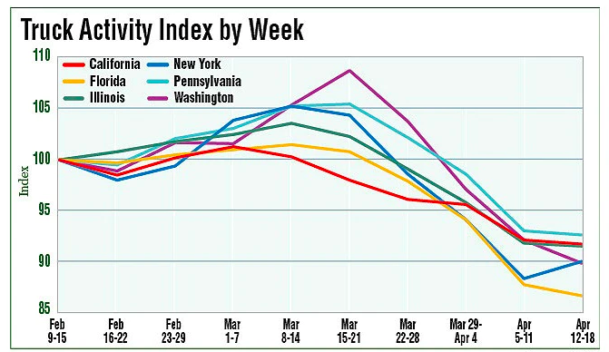
The impacts of COVID-19 have been less severe — but still significant — for the trucking industry. The U.S. trucking industry is an economic powerhouse, typically generating over 700 billion in annual revenue and transporting 72.5% of American freight. The American Transportation Research Institute generated a truck activity index based on GPS data across six states from the week of February 9 to the week of February 12. The data shows an initial spike in trucking operations due to increased demand for consumer goods and medical supplies. However, as stay-at-home orders and restrictions ceased business operations across the country, truck activity declined.
Source: American Transportation Research Institute
Coronavirus safety restrictions adopted by countries across the world have generally begun to loosen up, for better or for worse. It will be interesting to see how the coming months unfold through the lens of GNSS data.
Roi Mitt works for Regulus Cyber, a company researching GPS cybersecurity and offering various software products to protect the integrity, reliability and security of GNSS devices. The company’s products are designed for multiple industries using GPS-based time and location, in order to ensure a future in which GNSS technology is safe and reliable to use.
The Galileo Second Generation will phase in of new services, improve existing services and increase security
The technology multinational GMV is playing a key role in the Galileo Second Generation (G2G) ground segment.
G2G’s main objectives are to phase in new services, improve existing services, and boost system robustness and security while cutting both operating and maintenance costs, to cement Galileo’s position as one the future’s top GNSS.
Three phases. G2G is divided into several phases. In the first, led by the European Space Agency (ESA), mission requirements were defined at system level. This was followed by a preparation phase, then an implementation phase.
As well as priming several mission-requirement projects, GMV, since 2018, has been heading one of the consortia working on G2G’s complete ground segment during the preparation phase.
Within the preparation phase — shortly before the start of the COVID lockdown — ESA announced the successful end of the first phase before launching a bid invitation for the second phase as the prelude to G2G implementation.
Although publication of the bid invitation for this phase was eventually pushed back until mid-June, GMV never broke off its G2G activities. In recent months GMV has brought new recruitments and partners into the project team while also working on new ideas and kicking off some project activities.
Team members have attended various skills-training courses, some of them gaining certification under SAFe 5 Agilist. During these months, GMV has also been working under new pandemic circumstances with teleworking, virtual meetings and new toolboxes.
First Generation. Galileo First Generation (G1G), running since December 2016, consists of space infrastructure (26 satellites to date) and ground infrastructure. Galileo is now providing 20-cm-precision positioning, navigation and timing services for over 400 million users around the world.
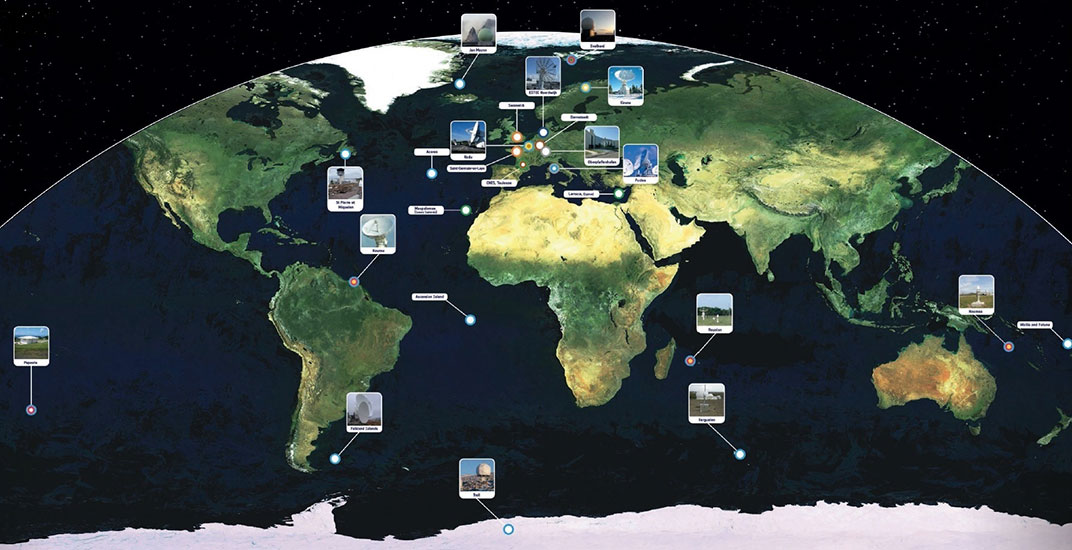
The worldwide Galileo ground segment includes two control centers (Italy and Germany) as well as various tracking, uplink and sensor stations and monitoring and test centers. (Image: ESA)
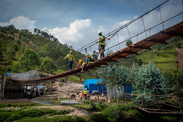
A shipping container with several pieces of key GNSS and survey instrumentation is bound for the East African country of Rwanda. The equipment, an in-kind donation from Topcon Positioning Group, will be used in support of Bridges to Prosperity (B2P), an organization committed to building trail bridges to improve the lives of people in rural areas worldwide.
Photo: Bridges to Prosperity
According to B2P, almost a billion people around the world lack safe access to critical resources like healthcare, education, or employment due to an impassable river. Building safe, structurally sound trail bridges for people to travel by foot, bicycle, or motorcycle has an immediate, impactful effect on the lives of those in the area.
“We are fortunate that, even with challenges presented by the COVID-19 pandemic, we have been able to implement new safety measures with limited disruption to our building schedule,” said Devin Connell, B2P’s corporate program director. “Right now, our surveying efforts predominantly involve simple equipment such as auto levels and range finders, which can be time consuming when complex survey information is needed. The equipment from Topcon will increase our surveying capabilities, streamline the design process, and support us in building more trail bridges for isolated communities.”
Photo: Bridges to Prosperity
In addition to the instruments — a pair of GNSS receivers, two total stations and data collectors — B2P will have access to the Topcon suite of software products, which will assist both the design process and the transfer of files from the field to their remote office or the engineering team working with them. According to Ron Oberlander, vice president of Topcon Global Professional Services group, however, the company’s role extends well past the equipment itself.
“We are excited to be a contributing part of this program,” he said. “But, in order for B2P to use these solutions to their fullest and increase their overall productivity, a training effort will be needed and we’re already setting plans in place for that to happen.
“In addition to conducting online virtual training sessions with B2P staff, we are making eLearning possible by allowing access to MyTopcon, our company knowledge portal. With these tools, they can gain familiarity with their receiver or total station or use the Topcon software to learn how to collect points — all without having us there. They want to be able to hit the ground running once the equipment arrives and this will help make that happen.”
Connell said that their improved survey capability will help accelerate the company’s bridge building. “We go out and survey a year in advance, looking at as many as 100 different remote sites and, tough as it might be, establish priorities with the local governments. We are looking forward to our continued growth in 2021 and, thanks to the generosity of companies like Topcon, that process will be a much better one.”
“Seen & Heard” is a monthly feature of GPS World magazine, traveling the world to capture interesting and unusual news stories involving the GNSS/PNT industry.
Photo: welcomia/ iStock / Getty Images Plus / Getty Images
COVID brings better measurements
A new study shows that the quality of GNSS reflectometry measurements may have improved significantly during the pandemic because of the lack of cars parked near the ground station. The study, carried out by geodesists from the University of Bonn, investigated the location of a precise GNSS antenna in Boston, Massachusetts, where parked cars near the ground station decreased accuracy from 2 to 4 centimeters. GNSS reflectometry is used for earthquake early warning systems, determining flood risks, and many other geodesy applications. Read more about the study.
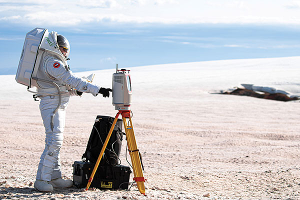
Photo: Daniel Leeb/Iceland Space Agency
But can you press the right button?
A Riegl long-range terrestrial laser scanner helped field test the newly designed MS1 Mars Analog Spacesuit. The test simulated how the new spacesuit design would perform in a polar, Mars-like environment ‚ in this case atop the Grimsvötn Volcano on the Vatnajokull Glacier in Iceland. The field test was part of a research expedition conducted by the Iceland Space Agency. The team included NASA Coordinator and Rhode Island School of Design (RISD) Professor Michael Lye, who led the team that designed the MS1, and doctoral students from the University of Iceland.
In June, a fleet of 300 Chinese fishing vessels entered the waters of the Galápagos Islands, reports environmental news website Mongabay. The ships had ostensibly turned off their GNSS-based automatic identification system (AIS) transponders to engage in illegal activities. Their presence was detected by their overhead lights and industrial jigging machines to attract and catch squid. An analysis of radio-signal data also detected unidentified ships within Ecuador’s Galápagos exclusive economic zone (EEZ).vThe new data provide additional, but still inconclusive, evidence that the Chinese fleet may have entered Ecuador’s EEZ.
A pilot program in Shenzhen will use China’s BeiDou to regulate bike-sharing and address the problem of bikes parked chaotically or in unpermitted areas, according to Chinese news service Caixin. The program is part of Beijing’s push for wider adoption and commercialization of BeiDou. With guidance from the city’s transportation bureau, BeiDou modules on shared bikes will display parking spots. Users will have to park them within geofenced parking spots.