Hoptroff’s Traceable Time as a Service to become an option for Orolia’s product portfolio; webinar scheduled for Dec. 15
Orolia and timing solutions provider Hoptroff are partnering to deliver a service combining Orolia’s resilient positioning, navigation and timing (PNT) solutions with Hoptroff’s timing synchronization software.
The collaboration will offer Hoptroff’s Traceable Time as a Service (TTaaS) as an add-on to Orolia’s suite of products, providing precise and verifiable time to customers in enterprise, financial, telecom, utilities, public safety, and other markets where traceable time is critical.
Webinar scheduled
Orolia and Hoptroff will host a joint webinar to discuss the partnership and new resiliency options for customers on Dec. 15 at 12 p.m. EST. Register here.
Hoptroff’s TTaaS offers an additional level of security and precision to meet stringent regulatory and resilient infrastructure requirements by delivering accurate time over the network using a VPN connection over broadband or fiber networks.
The bundled solution will simplify the challenge of getting accurate, traceable time in applications where GNSS access is not available or dependable. It can also serve as an accurate, reliable backup to GNSS to provide a high level of resiliency to timing systems being used in critical infrastructure.
“As industries evolve and computer applications become more complex and widely distributed, it is essential that devices in a distributed process share the same accurate timescale to reconstruct digital events after the fact,” said Tim Richards, COO at Hoptroff. “Network-based traceable timing, such as TTaaS, provides resilient backup to a GNSS installation in the case of signal disruption, monitors the quality of performance of time servers, and keeps a record of this timing quality at a location of the customer’s choice. Our partnership with Orolia means businesses will now be able to back up and monitor physical time servers and virtual servers in the cloud, so that they can be sure they share the same accurate timescale, and they have the records to prove it.”
“The partnership with Hoptroff aligns with Orolia’s resilient PNT strategy by providing a wireline solution to augment its space-based PNT solutions. This allows us to further simplify the challenge customers face when building a highly resilient timing solution,” said Jeremy Onyan, Orolia’s director of time sensitive networks. “By combining Orolia’s anti-jamming and anti-spoofing solutions, high-performance GNSS-based timing products, alternative signals like STL, a local high-quality oscillator, and now a wireline-based TTaaS we have one of the most robust portfolios of resilient PNT solutions in the market. Additionally, with the recent acquisition of Seven Solutions, we are well positioned to extend our capabilities into high-accuracy time distribution.”
Seven Solutions is a global innovator in White Rabbit sub-nanosecond time transfer and synchronization technology. “With the capability to distribute time with little to no accuracy loss, Orolia’s customers using Hoptroff’s TTaaS or other time references such as GNSS can extend that time to other parts of their networks and create a high level of resiliency against potential outages,” Onyan added.
ADVA has introduced its OSA 5400 SyncModule embedded timing solution, designed to enable technology suppliers to integrate precise synchronization into their hardware. Its M.2 form factor can add crucial timing capabilities to switches, routers, open compute servers and other IT devices.
The OSA 5400 SyncModule provides GNSS, precision time protocol (PTP) and network time protocol (NTP) engines as well as comprehensive PTP and GNSS monitoring and assurance functionality. According to ADVA, the module can enable assured sub-microsecond timing in public and private networks as well as critical infrastructure.
“Our OSA 5400 SyncModule brings something completely new and very valuable to the market,” said Gil Biran, general manager, Oscilloquartz, ADVA. “For the first time, third-party technology manufacturers will be able to embed the most advanced synchronization capabilities into their designs and easily control them with our Ensemble Sync Director or their own management system.”
Featuring multiple interface options for easy integration, the OSA 5400 SyncModule comes with an open API. It can also be managed by ADVA’s proven Ensemble Sync Director management system.
Chronos Technology Ltd., a UK-based resilient synchronization and timing company, has transitioned to employee ownership through the Chronos Technology Employee Ownership Trust (EOT) Ltd.
Charles Curry who established Chronos Technology in September 1986 and was co-owner alongside his wife, Angela Curry, had been deliberating succession planning and their exit from the business. Various options such as a third-party sale or a management buyout were considered but quickly dismissed.
“I am aware of business owners who had exited through third-party sales and had not enjoyed the experience of working under new management for the agreed handover period,” Curry said. “New owners generally change the dynamic of the business, often introducing new staff and work practice without giving opportunity to existing staff and process, and we did not want this for Chronos.”
“Over the years we have established a work ethic that puts the customer first,” Curry continued. “The EOT protects the loyal Chronos family and ensures the customer-facing continuity of the business and, most importantly, safeguards jobs. Going forward, in the hands of the employees, the company will benefit from increased customer engagement and the commitment to a team approach to steer the business on the next phase of its journey.”
Chronos Technology specializes in resilient synchronization and timing systems, smart technologies, GNSS and cybersecurity solutions for critical national infrastructure, with industry experience gathered over 35 years in specialist technologies such as GNSS, PTP, NTP and SyncE.
The company provides GPS coverage solutions in hangars, manufacturing areas and underground, as well as smart technology solutions and GNSS jamming detection and location solutions for law enforcement. Customers include telecom, finance, energy, data centers, broadcast, aerospace, defence and security, enterprise/IT, emergency services, transport and manufacturing.
Merger to deliver high-end performance and ultra-accurate timing and frequency products for commercial, critical infrastructure and defense markets worldwide
Orolia has entered into a definitive agreement to acquire Seven Solutions, a global innovator in White Rabbit sub-nanosecond time transfer and synchronization technology. This transaction is subject to customary closing conditions and approvals required by the Spanish government and is expected to close before the end of the year.
This is Orolia’s 11th acquisition in the past seven years.
The merger with Seven Solutions, based in Granada, will enhance Orolia’s portfolio for defense, aerospace, data centers, telecom, financial services, smart grids and other critical infrastructure industries, and will enable the next-generation applications dependent on ultra-precise, resilient timing and frequency technology.
“Orolia and Seven Solutions under one umbrella will combine our world-leading technologies to draw a new frontier in network timing to sub-nanosecond levels, delivering the most robust and accurate resilient PNT solutions for our customers,” said Orolia CEO Jean-Yves Courtois. “Seven Solutions’ long history of delivering cutting-edge time distribution solutions to sectors like telecommunications, smart grids, aerospace, defense and scientific facilities aligns perfectly with Orolia’s DNA.”
Orolia and Seven Solutions will integrate global sales, marketing, product development and operations.
Orolia’s full-scale, modular approach to resilient PNT includes atomic clocks with a combination of GNSS signals protected with interference detection and mitigation technology, together with low-Earth-orbit secure alternative signals. The addition of Seven Solutions’ products will deliver terrestrial sub-nanosecond time distribution from distant and potentially redundant locations.
“We believe the union of our companies will produce the future of time transfer and frequency distribution solutions in terms of accuracy, reliability and interoperability,” said Rafael Rodriguez, chief technology officer and co-founder of Seven Solutions. “Finance, 5G telecommunications, data centers and hyperscalers have new and upgraded functionalities requiring ultra-accurate time distribution accuracy. To maximize interoperability, our solution for time transfer is based on the White Rabbit concept that has been pushed over the last decade to become the basis of the standard high accuracy time transfer profile (within the recent release of IEEE 1588 of precision time protocol).”
Orolia and Seven Solutions are members of the Open PNT Industry Alliance. The international organization focuses on market concepts that strengthen economic and national security by supporting government efforts to implement resilient PNT capabilities for critical infrastructure.
Knowing your position is only part of navigation. (Photo: Oliver Montenbruck)
By Oliver Montenbruck and Peter Steigenberger
A year ago, the U.S. Global Positioning System celebrated its silver jubilee upon completing 25 years in operation. Also, it was more than 20 years ago that President Clinton agreed to switch off Selective Availability, thus offering seamless positioning to the civil community. The 10-bit GPS week count experienced its second rollover, and people worldwide got addicted to a ubiquitous positioning capability in those decades. Be it for finding the nearest restaurant or to track a Sunday afternoon bike ride, positioning-related services building on GPS have become an integral part of our daily life. In fact, GPS has almost become a synonym for navigation itself.
One cannot underestimate the contribution that GPS has made to society. It is for sure most deserved that the fathers of GPS were ultimately awarded the highly prestigious Queen Elizabeth Prize for Engineering in the year of the above jubilee. As always, success creates followers, and GPS is no longer the sole player. Next to the Russian GLONASS, two new actors — namely the European Galileo and the Chinese BeiDou-3 GNSS — have mounted the stage. So, users are now offered a choice of four independent GNSS.
However, do we really need so many systems? Isn’t one enough and all others just a waste of taxpayers’ money? The answer to the last question is certainly a clear “no.” Our society already depends on, to a large extent, the availability of positioning, navigation and timing (PNT) services in much the same way we depend on electricity and telecommunication. While mass-market applications such as the ones mentioned above may appear dispensable, there are “hidden” but much more critical applications of GPS, such as synchronizing power lines, stock trading or the base stations of cellular networks.
Clearly, there is a well-justified rationale for nations or groups of nations to build their independent, space-based navigation systems. Well beyond possible military considerations, this is a basic strategic interest for protection of the local economy and of critical infrastructure. Along with these interests, various regulatory conditions may apply that only endorse the use of selected systems for specific applications, such as emergency call systems. Overall, however, all GNSS in place today can be received and utilized by all interested users around the globe.
So, let’s have a closer look at the practical relevance and implications of having four GNSS in parallel for both mass-market and high-end users. The most obvious consequence is certainly an almost four-fold increase in the number of satellites. As of today, the four GNSS comprise more than 100 satellites, out of which 30 to 40 are simultaneously visible and available for positioning at common sites with open-sky conditions. As a rule of thumb, this provides a factor-of-two reduction of statistical errors compared to using only GPS.
Most importantly, however, the prospects for tracking enough satellites for positioning in obstructed sites is greatly improved. The larger number of visible satellites is particularly appealing for GNSS radio scientists who aim to derive temperature and humidity profiles from subtle variations in GNSS signals passing through diverse atmospheric regions. Multiple GNSS allow for better resolution and ultimately benefit weather forecasts.
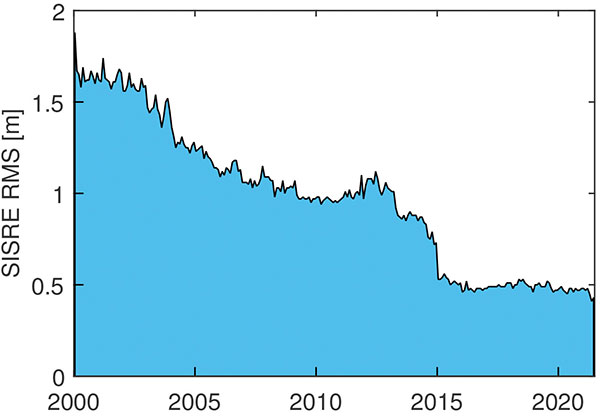
In terms of positioning, the simple statistical benefits of tracking a large number of satellites are probably outweighed by technological advances in GNSS satellites and ground systems, as well as substantial progress in receiver technology. For GPS, the signal-in-space range error (SISRE) that describes the contribution of broadcast orbit and clock errors to the position accuracy has decreased by more than a factor of three (Figure 1).
FIGURE 1. Evolution of the GPS signal-in-space range error over time. (Image: O. Montenbruck and P. Steigenberger)
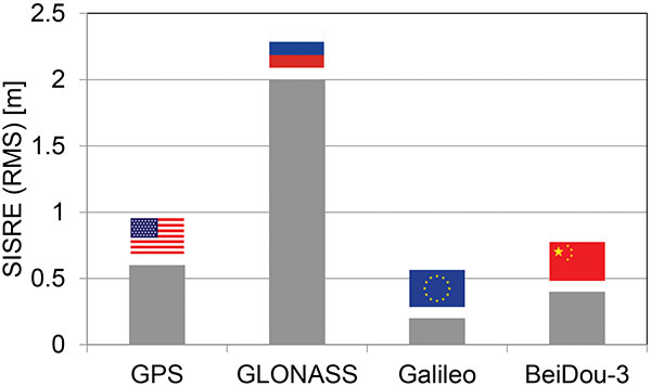
For GPS, but also Galileo and BeiDou-3, the use of highly stable atomic frequency standards has contributed to a notable reduction of the error budget of broadcast ephemerides. The same applies for fast upload capabilities, as in Galileo, or the use of intersatellite links in BeiDou-3. With SISRE values of 0.1–0.2 m and 0.3–0.4 m, these constellations enable even more accurate positioning today than GPS and GLONASS (Figure 2).
Figure 2. Signal-in-space ranging errors of the four GNSS. (Image: O. Montenbruck and P. Steigenberger)
However, improvements from new signals and multiple constellations are not only limited to single-point positioning, but likewise apply for precise point positioning (PPP) users. Stable clocks onboard the satellites reduce the update rate and bandwidth for real-time correction users. Digital signal generation units in modernized satellites ensure clean chip shapes in the transmitted ranging signals and reduce the scatter of satellite/receiver biases. Last but not least, the increased number of tracked satellites contributes notably to reducing the convergence time required for successful ambiguity fixing.
Concurrent progress in receiver technology was certainly a prerequisite for being able to track the multitude of new signals that became available with the new and modernized constellations. Compared to early GPS receivers with a few tens of channels, modern geodetic receivers may (or even must) support in the order of 1,000 channels. For mass-market users, the recent introduction of dual-frequency chipsets for mobile phones and car navigation systems marks the most important step forward. These chipsets support joint tracking of signals from GPS, Galileo and BeiDou-3 at the common L1/E1/B1 and L5/E5a/B2a center frequencies. The signals’ chipping rates, modulations and signal power are designed to offer reduced measurement noise, better multipath protection, and improved weak-signal tracking. At the same time, the use of two signal frequencies allows for rigorous elimination of ionospheric path delays, thus removing the biggest contributor to the error budget of low-cost positioning devices.
All in all, the availability of four GNSS means better performance, robustness, diversity and flexibility for navigation users. We should not forget, however, that all GNSS use basically the same core technology and share the same vulnerabilities. We must still give due attention to the challenge of toughening, augmenting and complementing GNSS to meet society’s needs for robust and assured PNT.
Oliver Montenbruck is the head of the GNSS Technology and Navigation Group and Peter Steigenberger is a senior scientist at the German Space Operations Center, German Aerospace Center (DLR).
The free resources are intended to advance the design of PNT systems and increase resilience of critical infrastructure to PNT disruptions.
The GPS Whitelist Development Guide presents a software assurance approach to addressing potential vulnerabilities and increasing reliability of GPS receivers. The guide addresses data-related requirements in the Resilient PNT Conformance Framework, which provides guidance for defining expected behaviors in resilient PNT equipment.
“We hope this guide and related resources will help industry advance towards a cybersecurity-based approach to PNT resilience,” said S&T Technical Manager Ernest Wong.
Originally released in March 2021 as open source on GitHub, the PNT Integrity Library provides users with a method to verify the integrity of the received GPS data. The update includes:
A compliance check on Interface Control Document (ICD) IS-GPS-200, which is a formal means of establishing, defining and controlling communication between the GPS space and other user systems; and
A Do-It-Yourself (DIY) Toolkit, which describes how a perspective end-user of the PNT Integrity Library can assemble a demonstrational toolkit with commercial-off-the-shelf (COTS) hardware.
“Since GPS signals can be jammed or spoofed, critical infrastructure systems should not be designed with the assumption that GPS data will always be available or will always be accurate,” said S&T Project Manager Brannan Villee. “Application of these tools will provide increased security against GPS disruptions. However, DHS also recommends a holistic defense strategy that considers the integrity of the PNT data from its reception through its use in the supported system.”
Hexagon | NovAtel has updated its GPS Anti-Jam Technology (GAJT) portfolio with the new GAJT-710 product line, which features several enhancements over the previous generation.
The GAJT-710 product line is the next evolution of NovAtel’s battle-proven anti-jam technology for land and marine platforms. The new jammer direction-finding capability of GAJT enables situational awareness and a new silent mode feature reduces its thermal signature. These improvements, including enhanced GNSS tracking performance, are achieved while maintaining the same form and fit of the previous generation product.
GAJT units are deployed worldwide, providing anti-jam protection on land, at sea and in the air. Across these environments, GAJT protects GNSS navigation and precise timing receivers from the growing threats of intentional jamming and unintentional interference. GAJT reliably provides APNT for allied forces no matter the scenario.
“NovAtel has proven itself as a leader for assured PNT through our GAJT portfolio,” said Steve Duncombe, executive vice president of aerospace and defense at Hexagon’s Autonomy & Positioning division. “The new GAJT-710 builds on that success by providing new features combined with existing mission-proven technology to continue providing evolutionary APNT capabilities for the warfighter, national infrastructure and other mission-critical applications.”
NovAtel’s commitment to APNT is central to its product design approach. Deep GNSS expertise and lean manufacturing capabilities enable the delivery of high-performance products like the GAJT-710 in large volumes with minimal production and delivery times, the company said.
The GAJT-710 product line is available for land vehicles, marine vessels, positioning networks and timing infrastructure.
Technology evaluation capabilities inaugurated in demonstration for U.S. Department of Homeland Seurity
NextNav and Satelles Inc. have partnered on an alternative positioning, navigation and timing (PNT) testbed in the San Francisco Bay area.
Designed and managed by NextNav with a timing source from Satelles, the testbed creates scenarios and conditions to rigorously test the precision and resilience of alternative PNT solutions, allowing technologies to be evaluated in the absence of signals from GPS and other GNSS.
NextNav used the testbed to demonstrate the precision and resilience of the company’s TerraPoiNT network in a GPS-denied environment using STL from Satelles as its absolute timing source. This demonstration for the U.S. Department of Homeland Security (DHS) showcased the timing accuracy and resilience of TerraPoiNT, which delivered timing synchronization better than 50 nanoseconds in urban and semi-urban settings.
As a source of GPS/GNSS-independent time that the U.S. National Institute of Standards and Technology (NIST) determined is highly consistent with Coordinated Universal Time (UTC) — including in deep indoor environments — STL provided the timing signal for the demo instead of GPS.
The advent of the alternative PNT testbed is timely given the recent publication of “Understanding Vulnerabilities of Positioning, Navigation, and Timing” by the Cybersecurity and Infrastructure Security Agency (part of DHS). This important CISA publication urges owners and operators of critical infrastructure to adopt the responsible use of PNT as defined in Executive Order 13905. The new testbed will be used to demonstrate applications for emergency services, telecommunications, financial markets, the electrical grid, and other critical infrastructure sectors.
“Demonstrating the accuracy and resilience of alternative PNT solutions is integral in validating the capabilities of alternative PNT solutions and, ultimately, increasing adoption across use cases and applications,” said Ashu Pande, TerraPoiNT VP at NextNav. “With the development of this testbed, we can emulate real world deployment scenarios and can more effectively instill confidence across the PNT industry in the viability of alternate PNT solutions.”
“The development of this testbed will enable the rigorous, transparent, and replicable testing of alternative PNT solutions,” said Christina Riley, VP of Commercial PNT at Satelles. “We’re excited to be integrated as the GNSS-independent timing reference for this alternative PNT testbed and are looking forward to continuing our collaborative work to build stronger PNT solutions to augment GPS globally.”
The U.S. Department of Transportation categorized TerraPoiNT from NextNav and STL from Satelles as the top-ranked PNT systems in its technology demonstration report released in January. The testbed collaboration between these complementary alternative PNT service providers underscores the companies’ commitment to promoting the adoption of multiple technologies that complement and augment GPS/GNSS to protect the operations of critical infrastructure.
The trial for the U.S. Department of Homeland Security showcases the precise, resilient timing capabilities of NextNav’s TerraPoiNT service in the event GPS is unavailable.
NextNav has successfully demonstrated the timing precision and resilience of its terrestrial positioning, navigation and timing (PNT) system, TerraPoiNT, in a recent evaluation by the Science and Technology Directorate of the Department of Homeland Security (DHS S&T).
The trial tested the timing redundancy of the TerraPoiNT system in a number of scenarios, including instances of GPS outages, spoofing and jamming. It validates TerraPoiNT’s capabilities as a terrestrial, GPS-free network capable of powering critical national infrastructure in the event of GPS failure.
During a simulated 72-hour GPS outage, the TerraPoiNT service was able to deliver a timing accuracy better than 50 nanosecond in urban and semi-urban environments, successfully meeting timing requirements for various applications including 5G networks, the synchronization of the power grid, and more.
In addition, TerraPoiNT provided precise timing and redundancy utilizing two alternate absolute timing sources — atomic clock (Cesium/Rb) and LEO satellite (Satelles).
“GPS is critical infrastructure, but it has its limitations,” said Ganesh Pattabiraman, co-founder and CEO of NextNav. “In working with DHS S&T, we’ve validated that TerraPoiNT can serve as an important backup to GPS and ensure the resilience and continuity of our nation’s most critical systems, including next-generation telecommunications networks, financial services, and power grids.”
Satelles STL
STL from Satelles was one of two alternate absolute timing sources for the trial. Available today on a global basis, STL is a service that provides alternative PNT independent of GPS, supporting PNT-reliant applications such as 5G communications networks, high-frequency trading in financial markets, and electrical grids throughout the United States and around the world.
“Satelles applauds NextNav for conducting a successful field demonstration of its resilient PNT service, and we were delighted to have played an instrumental part in the exhibition,” said Christina Riley, vice president of Commercial PNT.
NextNav’s selection of STL to help demonstrate their own technology’s operation in the absence of GPS was a natural fit. That’s because earlier this year the U.S. National Institute of Standards and Technology (NIST) confirmed STL as an accurate and reliable source for the wide-area delivery of Coordinated Universal Time independent of GPS/GNSS.
Previous TerraPoiNT evaluations
The successful trial builds on recent evaluations of TerraPoiNT conducted by independent bodies. Earlier this year, the Department of Transportation (DOT) evaluated 11 alternate PNT solutions, in which each was rigorously tested across applications and scenarios. As a result of the evaluation, the DOT named TerraPoiNT the best and only performing solution across all PNT categories.
Spartacus. In June, NextNav entered into a definitive merger agreement with Spartacus Acquisition Corporation in a transaction that would result in NextNav being listed on the Nasdaq. The transaction is expected to close late in the third quarter of 2021 or early in the fourth quarter of 2021, subject to satisfaction of customary closing conditions.
Successful eLoran field trial using ADVA’s OSA 5420 Series demonstrates same accuracy and stability as GPS with much-improved resilience
UrsaNav and ADVA have conducted an enhanced long-range navigation (eLoran) field trial using UrsaNav’s eLoran receiver and ADVA’s Oscilloquartz grandmaster clock technology. The successful demonstration shows that eLoran offers a robust and reliable backup for GPS and other GNSS, and could be used to provide an assured position, navigation and timing (PNT) service.
The trial follows U.S. PNT Executive Order 13905 aimed at strengthening national resilience through PNT services, including protecting critical infrastructure such as electrical power grid and communication networks from rising cyber threats. By harnessing ADVA’s flexible OSA 5420 series, designed with assured PNT (A-PNT) technology, UrsaNav has shown that eLoran can provide a new layer of protection and significantly boost timing resilience and security.
“The success of this field trial demonstrates how eLoran, as part of ADVA’s assured PNT solution, can serve as a crucial backup for GPS,” said Charles Schue, CEO, UrsaNav. “We have shown how our technology enables ADVA’s grandmaster clock to receive UTC timing from the eLoran system for a period of several days with the same accuracy and stability as GPS. Of course, this capability is extensible to other GNSS as well. eLoran is far less vulnerable to unintentional jamming and spoofing disruptions or intentional attacks, thereby delivering nanosecond precision with even more resilience.”
“By partnering with ADVA, we’ve been able to show that our eLoran receiver interoperates with the best network timing toolkit available,” Schue said. “The OSA 5420 Series is a great product — highly efficient and easy to operate. Together with ADVA, we’re paving the way for tomorrow’s more robust assured PNT synchronization architecture. Now that UrsaNav has demonstrated the power of our OSA 5420 Series to utilize eLoran in the event of outages, we have another very important tool to ensure the quality and availability of time-sensitive services.”
UrsaNav’s latest trial used the OSA 5420 series grandmaster clock with built-in GNSS receiver. Timing stability from GPS was measured for several days. This was then replaced with eLoran for the same period with no loss of stability.
The test was conducted indoors where GNSS signals are not usually available, potentially extending the availability of precise UTC timing to many more environments.
“Commercially available GNSS jammers and spoofers are easy and cheap for attackers to acquire,” explained Nir Laufer, VP, product line management, Oscilloquartz, ADVA. “That’s part of the reason why we’re seeing a growing number of incidents across the world of blocked or misleading signals. If power utilities, enterprises, service providers and governments continue to rely on GNSS alone, it’s only a matter of time before the consequences become very serious. That’s why we’re committed to tackling GNSS vulnerabilities with advanced technologies like our ePRTC offering, cesium atomic clocks and our optical timing channel solution. Now that UrsaNav has demonstrated the power of our OSA 5420 series to utilize eLoran in the event of outages, we have another very important tool to ensure the quality and availability of time-sensitive services.”
The demo showed how ADVA’s synchronization technology enables protection for critical infrastructure that needs ultra-reliable aPNT solutions. (Photo: Business Wire)
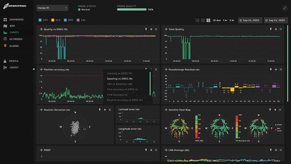
GPSPatron is offering products and services to protect equipment, particularly GNSS-dependent critical infrastructure. Its GP-Probe TGE2 is designed to protect time servers against threats including spoofing, jamming, ionospheric scintillation and system errors. An embedded PPS phase-error measurement function enables reliable monitoring of the time server’s health by measuring the time offset between internal and external PPS.
The GP-Probe, in conjunction with GP-Cloud, allows development of robust, resilient clock-synchronization systems. GP-Cloud is a web application for monitoring the quality of the GNSS signal and detecting anomalies in RAW GNSS data.
Every second, the three-channel GP-Probe measures several signal parameters of all perceptible GPS, GLONASS, BeiDou and Galileo satellites and sends them to GP-Cloud for real-time processing. GP-Cloud allows users to investigate GNSS signal parameters, recognize attack scenarios, and improve resiliency to current and future GNSS threats.
GPSPatron also provides laboratory testing services of GNSS equipment to identify vulnerabilities. It uses its own GP-Simulator to simulate spoofing attacks. Typical test objects are RTK base stations and time servers. Testing can help uncover possible attack scenarios.
GPSPatron offers its solutions as a service, providing monitoring without investments in new hardware and software, as well as leasing of equipment.
GP-PROBE TGE2 FEATURES
Three RF channels enable spatial signal analysis to detect coherent spoofing
60 MHz RF signal analyzer for spectrum monitoring with FPGA-powered correlative peak analysis for non-coherent spoofing detection and interference classification
Optional GP-Blocker with an embedded noise generator suppresses the most powerful counterfeit RF signals
Authenticated PPS output for synchronization of external equipment
PPS input for checking time server health and monitoring the entire synchronization system
Optional GP-divider enables use of one GNSS antenna for two receivers
Form factor of 19-inch rack, half-size
Double power module: 110 – 220 AC, 18 – 75 DC
Active/passive GNSS antenna support
4G modem and 100BASE-TX Ethernet for data transferring to GP-Cloud
The company’s TimePictra 11 timing infrastructure management system works with its BlueSky GNSS Firewall to create a unified view for a more secure network timing architecture
Image: Microchip Technology
Microchip Technology Inc. has integrated its BlueSky GNSS Firewall with its TimePictra 11 synchronization monitoring and management platform to protect 5G networks and other critical timing infrastructure from GPS signal jamming and spoofing while providing single-console visibility across the entire timing architecture.
The move was made to meet the needs of 5G wireless infrastructure, which has more complex and higher density synchronization needs than previous generation networks. 5G is highly dependent on the integrity of live-sky GNSS timing signals.
“Microchip’s TimePictra system improves overall situational awareness by managing network timing synchronization as well as our GNSS firewall that improves a network’s resilience through real-time GPS threat detection and mitigation,” said Randy Brudzinski, vice president, Frequency and Time Systems business unit. “Our solution’s scalability is particularly valuable for mobile operators who can use TimePictra to monitor GNSS-based source clocks along with our secure network-based timing distribution solutions to deploy a highly resilient timing architecture for their transition to 5G.”
In addition to requiring precise timing from GNSS sources, critical infrastructure operators need accurate timing to be distributed across their networks so they can ensure reliable performance and service delivery. TimePictra provides full control and monitoring for resilient timing architectures created with Microchip’s broad product portfolio, including its TimeProvider 4100 grandmasters for 5G network synchronization.
TimePictra also monitors the health and performance of these networks’ distributed Precision Time Protocol (PTP) client clocks. Integrating BlueSky GNSS Firewall management into the TimePictra console view gives operators a unified picture of the entire timing architecture and all timing sources.
Beyond supporting 5G deployments, TimePictra provides aviation, railway and maritime ports with a regional, national or global view of GNSS reception. TimePictra with BlueSky GNSS Firewall monitors key GNSS observables to detect live-sky signal anomalies and deliver early alerting so that operators can engage alternate procedures that do not rely on GNSS. These capabilities are increasingly important when public safety depends on position and navigation for daily operations.
Microchip’s TimePictra timing infrastructure management system with its Blue Sky GNSS Firewall is available today.