Recent GPS World webinars have focused on a variety of proven, resilient technologies to combat GNSS and positioning, navigation and timing (PNT) vulnerabilities in critical infrastructure.
Now a Sept. 17 GPS World webinar focuses on how PNT monitoring can further protect critical systems from these vulnerabilities through continuous monitoring and improvement.
The Orolia-sponsored webinar is free. It is scheduled for 1 p.m. EDT / 10 a.m. PDT / 7 p.m. (1900h) Central European Time. Register here.
Protecting critical infrastructure is now a national priority for the U.S. and allied countries. Similar to cybersecurity for network systems, effective GNSS and PNT protection involves identifying and monitoring weak entry points, knowing where and when an intrusion occurs, and providing data about new threats to help strengthen the system going forward. Its value applies across all critical infrastructure sectors such as telecom, power grids and data centers.
Webinar speakers include:
John Fischer Vice President, Advanced R&D, Orolia
For more than 15 years, Fischer has been part of Orolia where he works with global navigation satellite systems, wireless, positioning navigation and timing, as well as specialized systems for its customers. Prior to joining Orolia, he specialized in wireless telecom as a founding member of two startups: Aria Wireless in 1990 and Clearwire Technologies in 1997. At Clearwire, he served as chief technology officer in creating wireless broadband equipment for internet connectivity. Early in his career, Fischer worked as a systems engineer in radar, EW, and command and control systems at Sierra Research and Comptek Research. He holds master’s and bachelor’s degrees in electrical engineering and computing engineering from the State University of New York at Buffalo.
Tim Frost Strategic Technology Manager, Calnex Solutions
Tim Frost is a specialist in next-generation synchronisation techniques, having worked with Zarlink Semiconductor, Symmetricom and now Calnex Solutions on packet-based synchronisation technologies. He is an active contributor to the ITU-T, and has also contributed to the AVnu Alliance, Small Cell Forum, Metro Ethernet Forum and IETF. He has a BSc. in Electrical and Electronic Engineering from the University of Leeds, and a MSc. in Computer Systems Engineering from the University of Manchester.
Francisco Girela Americas Tech Responsible, Seven Solutions
Francisco Girela is the Americas Tech Responsible at Seven Solutions. He holds a Master’s degree in Telecommunications Engineering from the University of Granada. After some time in the private sector, Francisco joined the Timing Keepers group at the same university as a researcher. During his research, he specialized in ultra-accurate time transfer systems and he focused on the development of the White Rabbit technology. He combines his work for Seven Solutions with his studies for a Ph.D. in Telecommunications Engineering. This combination has provided Francisco with a strong technical background on high-accuracy time synchronization and deep knowledge on timing applications in industrial sectors.
Mobile GIS Services (MGISS) is working with the European Space Agency (ESA) to showcase the potential of satellite positioning systems and imagery in tackling some of the environmental and societal challenges being faced by the water industry.
The two organizations joined together to develop multimedia experiences, group exercises and real-world case studies, which will be shared at the Northumbrian Water Innovation Festival, taking place Sept. 15.
The four-day festival, which has attracted more than 6,500 visitors across previous events, will take place virtually from Sept. 14-17.
“Under the theme ‘We Need Space to Innovate,’ we are aiming to explore how we can use satellite services to improve asset management for organizations such as Northumbrian Water, alongside the wider water and critical infrastructure sectors,” said Mike Darracott, MGISS managing director.
A highlight of the organizations’ participation will their Daily Dashes. The Daily Dashes will be rapid, sprint-style workshops that run through all stages of the subject and include music, video, live demonstration and hands-on workshops to explore specific topics relevant to the water industry. According to MGISS and ESA, the Daily Dashes will provide a better understanding of how satellite services can be used to improve asset insight and operational performance.
“Satellite positioning systems are extensively used for asset location, and yet do users really understand the full array of technology on offer or the additional potential that can be derived from earth observation data?” Asked Alan Cross, regional ambassador for ESA. “By working with MGISS, we will demonstrate how improved positioning and asset insight has the potential to deliver benefits for operational resilience, improved safety and higher productivity.”
GPS World’s November 2020 issue will focus on water applications, so stay tuned for that issue.
The White House Office of Science and Technology Policy is asking for ideas on what technology to research to protect GPS. The research and development dollars are earmarked for projects that minimize or eliminate disruption to critical infrastructure from intentional and unintentional interference.
The office is seeking input “from all interested parties on the development of a National Research and Development Plan for Positioning, Navigation, and Timing (PNT) Resilience.
“The plan will focus on the research and development (R&D) and pilot testing needed to develop additional PNT systems and services that are resilient to interference and manipulation and that are not dependent upon global navigation satellite systems (GNSS).
“The plan will also include approaches to integrate and use multiple PNT services for enhancing resilience,” the RFI states.
The effort is specifically headed by the Subcommittee on Resilience Science and Technology (SRST.) “The input received on these topics will assist the subcommittee in developing recommendations for prioritization of R&D activities,” the RFI states.
Deadline for comments is 11:59 pm ET on Sept. 9.
Responses should be submitted via email to [email protected] — include “RFI Response: PNT Resilience” in the subject line of the message.
An international survey and analysis on GNSS interference detection and localization systems reveal the path forward for transportation and other critical infrastructure.
By José Luis Madrid-Cobos and Ana Bodero-Alonso, ENAIRE
Ignacio Fernández-Hernández and Eric Châtre, EC
Andriy Konovaltsev, DLR, and Christopher Hegarty, MITRE
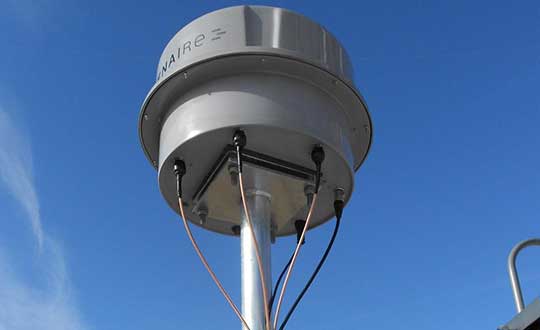
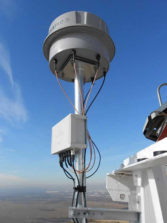
An ENAIRE GNSS RFI monitor close to the Madrid-Barajas Airport in Madrid, Spain. (Photo: ENAIRE)
The received power of GPS and Galileo navigation signals at the antenna output of a user receiver is typically extremely small, from approximately –165 up to –150 dBW, which makes them inherently vulnerable to radio-frequency interference (RFI) caused by the emissions of other radio systems. This interference is often unintentional, such as from malfunctioning or spurious emission from a transmitter in the vicinity of the GNSS receiver.
However, we have seen numerous reports about the deliberate jamming of GNSS signals. The most frequent examples of such interference reports are caused by so-called personal privacy devices (PPDs) — low-power GNSS jammers used to locally disable the operation of GNSS receivers. Although the use of PPDs is illegal, they can be easily acquired on the internet. A $10 jammer with 100 mW of transmitter power is enough to degrade performance or disrupt GNSS receivers in a range of 10–100 meters. In the past decade, more complex and powerful jammers have also become available, along with spoofers — devices that create GNSS-like signals that fool receivers to provide false location or time solutions. A $100 software-defined radio bought online can be used as a spoofer.
ENAIRE (the Spanish air navigation service provider) conducted an international survey and associated analysis of GNSS RFI detection and localization systems. The survey was part of the EU–U.S. Working Group C Sept. 2017–Sept. 2019 Work Plan, with contributions of the European Commission (DG DEFIS), the German Aerospace Center (DLR), the U.S. Federal Aviation Administration (FAA), Eurocontrol, the MITRE Corporation and Stanford University. Working Group C promotes cooperation between the U.S. and EU on design and development of the next generation of civil satellite-based navigation and timing systems. The survey was conducted within the Resilience Subgroup focused on counteractions required in view of growing concerns over jamming and spoofing threats.
Manufacturers and Users
The survey was provided in two versions: one targeted to manufacturers and another to the users of interference detection systems. The two surveys were implemented online July 12–Oct. 26, 2018. There were 23 responses: 11 from manufacturers and 12 from users (see Acknowledgments below for companies that participated). Regarding the manufacturers’ responses, the nine surveyed companies represent about 50% of the market of RFI monitoring products available in 2018.
RFI Equipment Used
We present here the aggregated results of the RFI equipment manufactured and used by the participating entities.
Frequency Bands and Signals. The L1/E1 band is covered by all of the manufacturers’ and users’ surveyed products. L5/E5a and other bands are monitored in only 42% of the cases, or even less. Most RFI systems demodulate or analyze the GPS L1 C/A signal. Only 8% and 17% of users analyze GPS L5 and Galileo E5a, respectively.
Capabilities. 55% of the industry, and 25% of the users’ surveyed products, provide RFI localization capabilities, while 45% of the industry, and only 33% of the users’ surveyed products, detect some type of spoofing.
Power and Antenna Gain. Most of the systems achieve a sensitivity better than or equal to –120 dBm, meeting the International Civil Aviation Organization requirement for GPS and SBAS L1 airborne receivers to withstand interference (–120.5 dBm CW, in-band) after steady-state navigation has been established. The gain of antennas used in RFI detection systems ranges from 2 dBi up to 45 dBi.
Real-Time Bandwidth. The maximum real-time monitored bandwidth of the surveyed products ranges from 16 MHz up to 60 MHz in L1. Most of the products monitor a 20-MHz bandwidth (similar to the GPS L1 C/A reference bandwidth for pre-GPS III satellites, which is 20.46 MHz).
Spectrum Refresh Time. The time needed by the RFI detector to capture and process a plot of the RF spectrum in a specific band to look for interference signals ranges from 1 microsecond to 2 seconds.
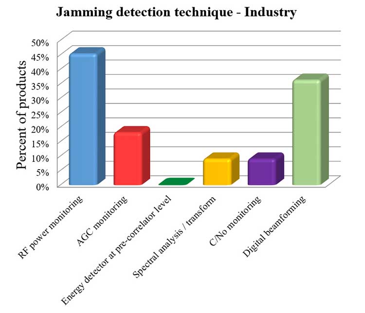
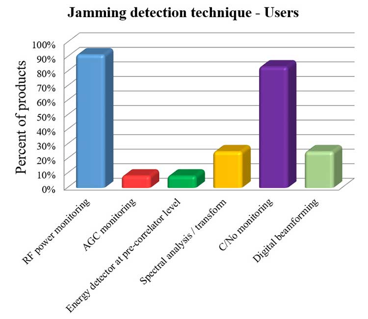
Jamming Detection Techniques. The most widespread jamming detection technique is RF power monitoring (45% industry, 92% users), followed by digital beamforming (CRPAs), carrier-to-noise-density ratio (C/N0) monitoring and spectral analysis/transforms (see Figure 1). Note that RF power monitoring and automatic gain control (AGC) monitoring are in essence the same detection technique: AGC voltage levels — after calibration with a reference RF generator — can be converted into RF input power levels.
Figure 1a. Jamming detection techniques used by industry. (Chart: RFI survey)Figure 1b. Jamming detection techniques of users. (Chart: RFI survey)
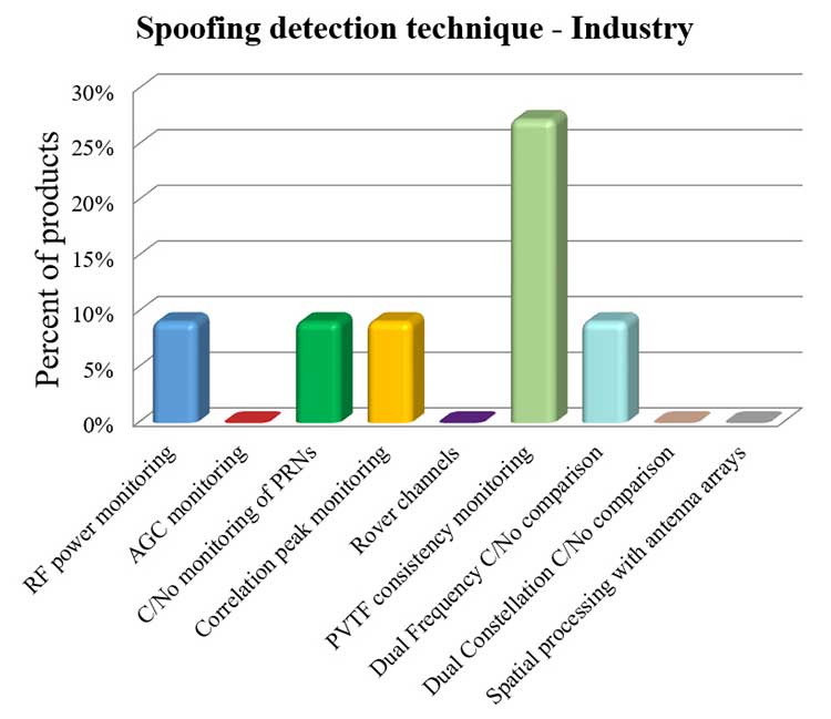
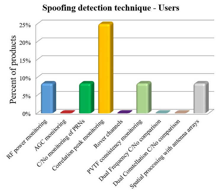
Spoofing Detection Techniques. The most widespread spoofing detection techniques are PVTF consistency monitoring (industry products, 27%) and correlation peak monitoring (users, 25%), followed by digital beamforming (CRPAs), C/N0 monitoring and spectral analysis/transforms (see Figure 2).
Figure 2a. Spoofing detection techniques used by industry. (Chart: RFI survey)Figure 2b. Spoofing detection techniques of users.(Chart: RFI survey)
Localization. The most widespread RFI localization technique is direction/angle of arrival (DOA/AOA): 55% in industry products and 25% in users’ systems. AOA techniques used are correlative interferometer (phase-difference), Watson-Watt (amplitude-difference) and array signal processing. The AOA accuracy of surveyed products ranges from ±3° to ±10°.
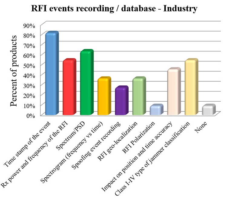
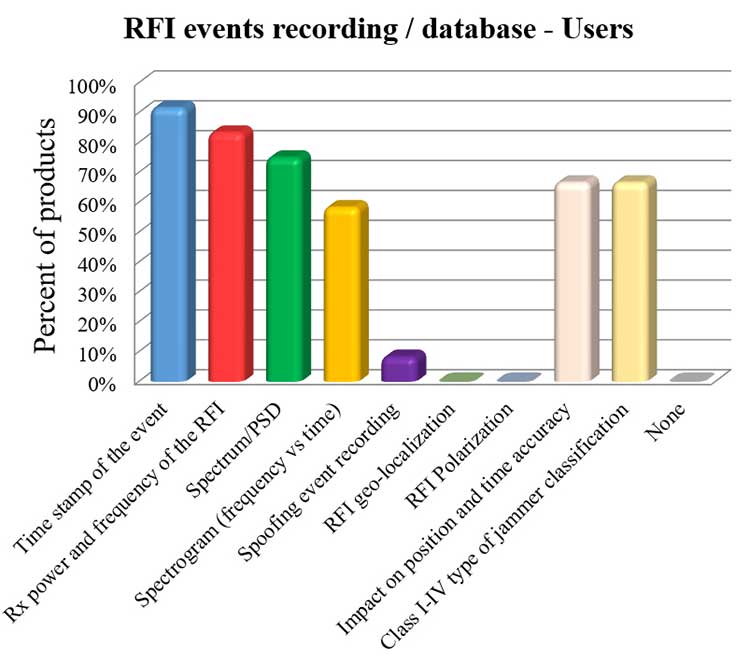
Event Recording. For an interference event, most products record the time stamp, received power, central frequency, frequency spectrum, the spectrogram (frequency versus time plot) and the jammer type. Only 8% of surveyed users perform spoofing event recording (see Figure 3). 92% of users record RFI/spoofing events; half also report them to their national spectrum administration. Users have from one to 11 jammer detectors. Only four users have been registered with spoofing detectors, each using one.
Figure 3a. RFI events recording/database used by industry. Jammer classifications: Class I — continuous wave signal; Class II — chirp signal with one saw-tooth function; Class III — chirp signal with multi saw-tooth functions; Class IV — chirp signal with frequency bursts. (Chart: RFI survey)Figure 3b. RFI events recording/database of users. Jammer classifications: Class I — continuous wave signal; Class II — chirp signal with one saw-tooth function; Class III — chirp signal with multi saw-tooth functions; Class IV — chirp signal with frequency bursts. (Chart: RFI survey)
Event Sharing. 75% of surveyed users are willing to collaborate in the creation of an international RFI and spoofing events common database, but the remaining 25% explicitly do not want to share their databases.
Future RFI Monitoring Equipment
Based on the analysis of the aggregated results from the survey, we identified some recommendations for improving RFI monitoring:
L5/E5a band. To be ready for introduction of the L5/E5a band into aviation operational use (expected by 2025), it is suggested that aviation organizations increase efforts to monitor and analyze the RFI situation in the L5/E5a band.
Spoofing detection. National organizations in charge of critical infrastructures should increase their efforts to detect spoofing (at least at the same level as jamming detection). Multi-constellation and dual-frequency spoofing detection should be promoted (not only L1/E1 spoofing).
GNSS RFI monitoring with enough bandwidth: The maximum real-time monitored bandwidth of the surveyed products ranges from 16 MHz to 60 MHz, while most of the products monitor only a 20-MHz bandwidth. The receiver reference bandwidth for E1 is 24.552 MHz, while for L1 GPS III it is 30.69 MHz. U.S.-EU GNSS RFI detection systems for critical infrastructures should be designed to monitor at least 31 MHz of bandwidth in the L1/E1 band, with 50 MHz recommended to cope with typical –3 dB bandwidth of pre-low-noise-amplifier (LNA) GNSS L1/E1 receiver filter. The same rule should be applied to other GNSS bands. Even more bandwidth for monitoring could be needed to cope with rare interferers, such as a high-power source, whether intentional or unintentional, radiating in near-band L1/E1 but not in the passband frequencies, bypassing the rejection of the receiver’s filters and degrading the GNSS signal reception.
Air Navigation
In the EU, performance-based navigation (PBN) will become the norm in all flight phases, and GNSS (with or without SBAS) will be the main position source, by June 2030. A similar scenario is being developed in the U.S. Conventional procedures and ground-based navigation aids will be used only in contingency situations. GNSS RFI can degrade the current GBAS CAT I (GAST-C) service in airports and could jeopardize safe operation of upcoming GBAS CAT II-III (GAST-D) service. GNSS also is the key enabler for ADS-B.
Therefore, it is critical for air transportation to improve its capability to detect radio frequency interference to GNSS and mitigate its harmful effects, both on the ground and in the air.
Ground Detection and Localization. These systems should be installed at and around all airports. ENAIRE has recently deployed an AOA RFI detection and localization system around the Madrid airport called DYLEMA. It consists of nine AOA RFI and spoofing detectors, two spoofing-only detectors, an IP communication network and a GNSS monitoring center operated 24/7. From this center, ENAIRE will report RFI events to the Spanish spectrum agency. Similar systems will be deployed in other large Spanish airports in the next years. In small airports, ENAIRE is deploying single-unit RFI detectors (one detector per airport, currently without the AOA feature). These systems are complemented by handheld and airborne spectrum analyzers equipped with directional antennas and RFI AOA features, used if an RFI event of high power or duration takes place.
Airborne Detection and Localization. Several initiatives are under study or initial design for airborne detection and localization systems, using current avionics receivers with no hardware modification or new hardware such as additional antennas in the aircraft. Future airborne RFI detection systems should include indoor coverage to detect jammers and spoofers in the airplane itself. EUROCONTROL is leading one of these initiatives using ADS-B. Given a reliable ADS-B data feed with suitable coverage information, a search algorithm could scan for outages. If the data is dense enough, it is possible to locate the source, even if the GNSS airborne antenna is omnidirectional with no AOA features. Another commercial initiative, GATEMAN, uses new GNSS antennas and components to provide AOA detection and localization features.
UAV-Embedded Detection and Localization. Detection and localization systems embedded in UAVs are not widely commercially available, but they will be useful to complement fixed or ground RFI monitoring systems, especially to detect fast moving mobile jammers and spoofers. A jammer moving at high speed could be found by a fixed detector, trigger the UAV take-off (collocated with the detector or close to it), and start tracking the target. If equipped with a camera, it could identify the vehicle carrying the jammer or spoofer. Such a system has to function in GNSS-denied scenarios, and needs to use sensors other than GNSS. Stanford University has recently developed a prototype of such a system.
Other Sectors
Shipping. RFI detection systems should be installed at and around harbors, where positioning requirements are the most stringent. Mobile AOA detectors can be installed in vessels. A DLR experiment integrated its GALANT GNSS RFI detector on a ship sailing from Spain to South Korea and back.
Railroads. Detection and localization systems should be installed at train stations and main railway junctions or switches. It is possible to install mobile detectors in trains to detect jammers inside the train apart from outdoor coverage to detect jammers outside the train.
Roads. Most PPD jammers in use are on roadways. Jammers not only jeopardize aviation and timing systems; they can jeopardize the safety of the coming autonomous road vehicles. We strongly recommend that police and road surveillance systems include jammers and spoofers as a daily target, to detect, localize and punish their users.
Supporting proposals include installing fixed detectors at tollbooths, road gantries or other points near roads; and using mobile detectors — for example, on police vehicles for locating a car that carries a jammer. Public transport services with enough vehicles (such as taxis or busses) could also detect RFI.
Smartphone Platforms. Initiatives are using smartphone crowdsourcing platforms to detect interference based on C/N0 or AGC measurements. At this time, only prototype apps for Android phones are available. The Apple iOS does not allow access to GNSS raw data. Android applications can include localization capabilities based on Time Difference Of Arrival (TDOA) or Power Difference Of Arrival (PDOA). Having a detection system in a mass-market product would create millions of detectors around the world. Reward programs by national or local administrations would encourage use of the app. User consent to obtain the data will be needed.
Space-Based Detection. Space-based detection is feasible to find medium- to high-power jammers and spoofers. Several projects have performed simulations, such as the ground to space threat simulator from Qascom and Spirent Communications. In this project, simulations achieved an error of less than 1.5 km using a medium-Earth-orbit (MEO) satellite as the RFI sensor and a 20-dBm static jammer on Earth, with 15 minutes of observation time. Also, an experimental program from the International Space Station has demonstrated that RFI can be detected from low Earth orbit.
The main issue of such detection systems is the cost to deploy all the satellites needed to have a global coverage with a low response time (2 hours or less to detect RFI). The performance of a space-based RFI system is better when using a LEO constellation (as, compared to an MEO system, it detects RFI with a lower transmitted power). One such system by HawkEye 360 was deployed in 2019. The company plans to operate a fleet of 30 satellites in LEO orbit, enabling it to gather new signals from any point on the planet within 30 to 45 minutes.
General Recommendations
Increased Effort Needed. Public administrations and transport service providers should increase their efforts to deploy GNSS RFI detection and localization systems. In parallel, governments should punish individuals or organizations using jammers or other types of illegal transmitters or emissions. Jamming and spoofing is illegal in the EU and the U.S. An increased RFI monitoring effort should be coordinated at the national or regional level to find synergies and avoid duplications.
Planned Interference. Government agencies, including national radiofrequency spectrum agencies, should coordinate nationally and internationally with air, rail, road, maritime and other critical infrastructure entities before any planned intentional interference is conducted, such as military exercises or protection of special events from potential terrorist attack. This coordination includes an analysis of the estimated area and airspace volume affected by the RFI, the associated notification to the GNSS users before and during the RFI radiation period (such as a NOTAM, Notice to Airmen), as well as the indication to use established alternative procedures (non-GNSS).
A Common Database. The creation of an international common database of GNSS RFI events could boost the fight against GNSS RFI. A specific action could define a standard of the RFI data format to be registered and shared in an international database, including a possible RFI classification (also defined and agreed to as part of the standard). One initiative related to the creation of an international GNSS RFI threats database was proposed by the EU-funded STRIKE 3 project in 2017.
Acknowledgments
The work presented in this report has been performed under the U.S.-EU Agreement on GPS-Galileo Cooperation, Working Group C, Resiliency Subgroup. The authors thank the participants of the Working Group and the Resiliency Subgroup — in particular, Eurocontrol and the FAA for distribution of the survey in the EU and the U.S., respectively. The authors also thank the organizations that participated in the survey: Spirent Communications, GMV, Centum Solutions, THALES, IDS AirNav, Chronos Technology, Innovationszentrum für Telekommunikationstechnik (IZT), Collins Aerospace, German Aerospace Center (DLR), Netherlands Aerospace Centre (NLR), Deutsche Flugsicherung (DFS), Direction des Services de la Navigation Aérienne (DSNA), Polish Air Navigation Services Agency (PANSA), Belgocontrol, ENAV and ENAIRE.
José Luis Madrid-Cobos is the technical manager of GNSS interference detection and localization systems at ENAIRE, the Air Navigation Service Provider in Spain. Ana Bodero-Alonso is the head of the Satellite Navigation Department at ENAIRE. Ignacio Fernández-Hernández is responsible for Galileo high accuracy and authentication at the European Commission. Eric Châtre is the head of the GNSS Exploitation and Evolutions Sector at the European Commission. Andriy Konovaltsev is a research assistant at Institute of Communications and Navigation of the German Aerospace Center (DLR). Christopher Hegarty is a technical fellow with The MITRE Corporation.
Orolia will host a second industry discussion on the positioning, navigation and timing (PNT) Executive Order, a federal initiative to protect critical infrastructure from GPS/GNSS jamming and spoofing threats, and other PNT service disruptions.
Speakers include:
John Pottle, Director, Royal Institute of Navigation
Greg Gerten, Director of PNT Operations, Centauri Corp.
Tyler Hohman, Director of Products, Orolia Defense and Security
The first Orolia PNT Coffee Talk, which focused on jamming and spoofing, is available here.
The second session — which takes place July 16, 2 p.m. EST — will explore the importance of vulnerability testing to protect critical infrastructure with Resilient PNT technologies. The defense industry has addressed complex GNSS and PNT threats longer than any other sector, and experts will share their insights and best practices to help inform the protection strategy for critical infrastructure identified in the Executive Order.
Vulnerability testing with GNSS simulation is essential to protect critical infrastructure. However, there is no one-size-fits-all approach. This testing requires the ability to customize scenarios per application. It also needs to identify gaps across a variety of unique and geographically distributed systems.
Test results provide the basis to select the best PNT technologies to increase resilience, while ongoing regular testing ensures that critical systems can adapt and overcome evolving threats.
The Orolia PNT Coffee Talk is for those interested in learning more and discussing the latest developments in this national priority from industry and government perspectives.
Orolia PNT Coffee Talk
Vulnerability Testing for Critical Infrastructure: Lessons Learned from Defense
U.S. Department of Homeland Security’s live-sky testing evaluations influenced development of BlueSky GNSS Firewall Software Release 2.0
Microchip Technology Inc. has released a major software update for its BlueSky GNSS Firewall product, providing a higher level of resiliency against GPS vulnerabilities for systems dependent on GPS signal reception.
Such systems include critical infrastructure such as power utilities, financial services, mobile networks and transportation that rely on GPS-delivered timing to ensure ongoing operations.
Microchip’s BlueSky GNSS Firewall Software Release 2.0 performs real-time analysis to detect jamming and spoofing for protecting reception of the GPS signal and hardening response and recovery to avoid signal disruption.
Release 2.0 includes charting and advanced threshold settings of GNSS observables such as satellites-in-view, carrier-to-noise, position dispersion, phase time deviation and radio frequency (RF) power level to simplify system turn-up and deployment.
The release also includes improvements developed by Microchip as a result of participation in a 2019 industry live-sky testing event hosted by the U.S. Department of Homeland Security (DHS) Science and Technology Directorate.
Microchip’s participation in the DHS-hosted GPS Testing for Critical Infrastructure (GET-CI) events included scenarios with spoofed signals, and helped the company identify new solutions to prevent signal disruptions. As a result, Microchip developed the Release 2.0 to address operators’ evolving requirements.
As a leader in frequency and time systems, Microchip continuously innovates GPS signal reception security technologies for commercial and military operators similar to how network firewalls protect against virus threats. Updates are essential to defend against rapidly-evolving GNSS disruptions and enable critical infrastructure operators to avoid interruptions of service.
When connected to Microchip’s TimePictra management software, critical infrastructure operators can monitor and analyze GNSS signals in cities, across geographic regions, throughout a country and even globally.
Other complementary devices and software in Microchip’s suite of GPS systems and services include the TimeProvider 4100 Precise Timing Grandmaster with Gateway Clock, SyncServer 600/650 timing and frequency instrument, miniature atomic clock (MAC), Time Cesium and 5071A cesium primary frequency standard.
Jackson Labs Technologies (JTL) has launched the PNT-6220 Assured Reference — a product combining low-Earth-orbit (LEO) signals, GNSS, terrestrial, wireline and atomic clock services in one small solution, specifically designed for critical infrastructure applications.
The PNT-6220 reference seamlessly combines concurrent L1, L2, L3 and L5 GNSS reception with a custom JLT-designed LEO-based Satellite Time and Location (STL) timing receiver. It also includes terrestrial receivers and PTP/IEEE-1588 edge grandmaster (EGM) and PTP/IEEE-1588-slave capability.
The PNT-6220 provides assured PNT for critical infrastructure applications such as those described in the directives of Presidential Executive Order 13905.
It can serve as a timing reference for 5G equipment, an ePRTC-capable reference, or a high-performance disciplined reference that supports PTP/IEEE-1588, STL, RF distribution and multi-frequency GNSS capability.
The PNT-6220 will be able to select the most optimal UTC reference input automatically and auto-switchover among its numerous reference inputs if one or more of them are jammed or spoofed, as well as average several references for additional stability and accuracy.
If all external references are jammed, the unit can provide UTC timing from its internal holdover oscillator with options that have less than 100-ns drift over 24 hours. The unit is also capable of outputting a GPS RF distribution signal driven by the internal flywheel oscillator, which allows glue-less retrofitting of any GPS-based legacy user equipment to the state-of-the-art reference sources the PNT-6220 can receive by simply plugging into the legacy equipment GPS antenna input.
Available Options
Numerous options are available for the half-width 19-inch-wide rack-mount box.
Orolia and Seven Solutions have partnered to deliver resilient, accurate, and stable time and frequency for global military, commercial and critical infrastructure applications.
According to the companies, the partnership will address the ultra-precise, resilient timing and frequency requirements of industries such as defense, aerospace, data centers, telecom, financial services, smart grids and other critical infrastructure.
Through the partnership, Orolia will offer a modular approach to resilient PNT, which includes a combination of GNSS signals protected with interference detection and mitigation technology, together with low Earth orbit secure alternative signals. The Orolia-Seven Solutions partnership also will offer terrestrial sub-nanosecond time distribution from distant and potentially redundant locations.
“This partnership is a key example of Orolia’s commitment to combining best-in-class technologies into more robust resilient PNT solutions for our customers,” said Orolia CEO Jean-Yves Courtois. “Those who require the most accurate, extremely precise time and frequency technology will now also benefit from an unprecedented level of resilience to protect critical PNT data sources, for more confidence and peace of mind.”
This new partnership between Seven Solutions and Orolia will facilitate global operations and naturally integrate with reliable time sources. Seven Solutions will focus on bringing the best-in-class time and frequency distribution, the companies said.
The U.S. Department of Homeland Security (DHS) Science and Technology Directorate (S&T) is hosting the 2020 GPS Equipment Testing for Critical Infrastructure (GET-CI) event. This event will take place during the summer of 2020.
The revised the due date for responses is May 8, 2020. Visit this site for more information.
S&T’s GET-CI events are a series of annual evaluation events intended for manufacturers of commercial GPS equipment used in critical infrastructure as well as critical infrastructure owners and operators.
DHS S&T recognizes the importance of accurate and precise position, navigation and timing (PNT) information to critical infrastructure and has a dedicated multi-year program to address GPS vulnerabilities in critical infrastructure, with a multi-pronged approach of conducting vulnerability and impact assessments, developing mitigations, exploring complementary timing technologies, and engaging with industry through outreach events and meetings.
Through these sustained efforts, the goal of the program is to increase the resiliency of critical infrastructure to GPS vulnerabilities in the near-term future.
Examples of measures that can be taken to enhance resiliency can be found in a DHS issued set of best practices released via ICS-CERT, titled “Improving the Operation and Development of Global Positioning System (GPS) Equipment Used by Critical Infrastructure.”
With the rise in public unrest from COVID-19 and increasing numbers of remote operations, the susceptibility and vulnerability of a cyber attack has never been greater.
On a regular basis, we hear intelligence experts proselytize an eventual cyber doomsday where our critical infrastructure (CI) — communications systems, information technology (IT) capabilities and financial networks — are compromised or disabled. These kinds of attacks could devastate our national and economic security and even disrupt basic day-to-day activities like turning on lights or buying groceries with a debit card. Even worse, a significant cyber event could escalate to the point of military actions between nation-states.
In 2012, Defense Secretary Leon Panetta warned about a potential “Cyber Pearl Harbor.” These threats were echoed by then head of Cyber Command, Gen. Keith Alexander, with hope the public, private and CI sectors would take notice of the broad, detrimental impacts of cyber threats.
Geoff Hella, Centauri Corp.
In kind, the Obama administration took aggressive steps to protect CI networks, and the Trump White House followed suit by enacting measures to strengthen the resilience of other technologies integral to our CI.
The latest White House Executive Order specifically addresses our reliance on position, navigation and timing (PNT) services and directs agencies to work in close coordination with the private sector to identify, secure and continue to improve the resilience of these technologies.
PNT services, such as GPS, are an extension of our IT systems, but despite this, PNT has been a relatively invisible utility and is oftentimes unknowingly utilized by most CI owners and operators. In the coming years, our reliance on PNT will only increase, making now a critical time to foster close collaboration between public and private sectors and determine which systems, networks and assets are dependent on PNT services. Identifying these dependencies will allow us to verify appropriate resilient PNT services being used, determine downstream effects of the disruption and manipulation of PNT services, and manage the associated risks to dependent systems.
The new directive is fast paced — outlined in 90-, 180- and 360-day increments — and instructs agencies to utilize existing public-private sector cybersecurity and CI information sharing relationships, such as Sector Specific Agencies (SSA), to share threat data, educate stakeholders and promote a responsible use of PNT.
What’s the rush?
So, why is this happening right now? PNT systems are crucial to American life, and successfully securing them requires a coordinated response and sooner rather than later. In fact, malicious nation-states, such as Russia, are spreading their wings into new threat vectors to inflict damage and are shifting their attention to PNT.
Because of these risks, we must do more as a country to establish safeguards around these technologies. That being said, agencies and organizations cannot expect their current workforce to become PNT security experts overnight. Rather, business owners and operators would be better served bringing in third-party experts that have been building security into PNT even prior to this directive.
These private-sector partners can map out a systematic approach to prioritize PNT security in a three-step plan:
Find. Identify PNT systems and “profile” them — establish point A.
Fix. Find and correct vulnerabilities — many can be non-material/tactics, technique and procedures (TTP) solutions.
Fortify. Develop TTPs, timelines and guidance for users to upgrade CI where needed — the path to Point B.
When PNT services were first developed, the systems could be openly used by anyone and security was not built into the original PNT architecture — similar to when the internet was created. This has made it easy for adoption into almost everyday life and revolutionized the world. Likewise, it has also made it easy for bad actors to access and compromise it, forcing the country to scramble, backtrack and implement cybersecurity best practices.
The good news is that we aren’t completely starting from scratch. The Department of Defense has been working to secure its PNT systems and will be updating its processes and practices as part of the recent White House directive.
The security community can also look to best practices in assessing risk of vital systems and model PNT security measures on existing guidelines such as Federal Information Processing Standards (FIPS) and NIST Special Publication 800 Series.
Path Forward
Per the Executive Order, lead agencies such as the Department of Transportation and the Department of Commerce will work in concert with the private sector to define “PNT profiles” and share these attributes with stakeholders. The coalition of partners will then be able to account for where and how PNT is used by CI owners and operators and will promote the responsible use of PNT services moving forward.
Beyond defining PNT profiles, the EO allocates new research and development funding for Commerce to develop an alternative to GNSS, which provides real-time PNT data to planes, trains, ships and automobiles that transport vital goods and resources — all in an effort to reduce the level of acceptable risk.
The White House also requires the public and private sectors to develop vulnerability testing and incident response plans and, simultaneously, encourage the private sector to use and develop more robust PNT services in anticipation of new Federal Acquisition Regulatory Council (FARC) contract requirements.
While these changes may seem like a fast moving and overwhelming process, there are many cases where CI owners and operators will not be required to integrate material solutions, but rather procedural training and behavioral adjustments. The information sharing processes already exist to provide improved situational awareness, coordination among the public and private sectors, increased reporting, solidified baseline risk assessments and a broader understanding of how systems rely on PNT. The challenge is facilitating widespread adoption across all stakeholders, increasing collaboration and education among and across the CI groups.
For this effort to be successful, it will require a whole-community, multi-pronged approach to operating in a new “threat top-of-mind” paradigm that is grounded on cross-sector information sharing, training and education. Both public and private sectors should also outsource expertise and leverage existing models like the DoD PNT doctrine, NIST standards and incident response capabilities.
Gregory Gerten is director of PNT Operations at Centauri, supporting the PNT enterprise through innovative use of modeling and simulation, hardware-in-the-loop and field testing, and process automation. He earned his master’s degree in electrical engineering from the University of Dayton, and has completed post-graduate courses in GPS from the Air Force Institute of Technology. He has more than 20 years of experience in system design, development and integration in the areas of communications, navigation, electronic warfare tactics and weapon systems.
Geoffrey Hella is a senior engineer for Centauri assigned to a Space Command contract through the Joint Navigation Warfare Center (JNWC). He has worked to achieve a Master of Aeronautical Science (MAS) from Embry-Riddle Aeronautical University in 1994. During his 40 years of experience, he has been a leader in product development and system design to successfully carry out a vast range of assignments in multiple engineering disciplines. His assignments include: aircrew member of the United States Air force (USAF); National Air Space (NAS) engineer for the Federal Aviation Administration (FAA); Special Nuclear testing and safeguards engineer for the Department of Energy/Sandia National Laboratories; and Supervisory Control and Data Acquisition (SCADA) engineer for both public and private Industry, electric and gas utility companies. Hella currently holds a six-sigma certification and a general radio operator license from the Federal Communication Commission (FCC) and a remote pilot operator certificate from the Federal Aviation Administration (FAA).
The PNT Coffee Talk event will be held online and is open to those interested in learning more and discussing this national priority from the industry and government perspectives.
The Executive Order, issued Feb. 12, is a federal initiative to protect critical infrastructure from GPS/GNSS jamming and spoofing threats, and other disruptions to critical PNT services. These threats can deny access to, or compromise, essential PNT data that critical infrastructure needs to operate.
This initiative, titled “Executive Order on Strengthening National Resilience through Responsible Use of Positioning, Navigation and Timing Services,” includes the following critical infrastructure: defense, homeland security, transportation, power grids, communications/mobile, precision agriculture, weather forecasting and emergency response.
Key actions include assessing jamming, spoofing and other PNT disruption risks across these critical infrastructure programs, developing customized PNT profiles to address risks, and deploying Resilient PNT technology to increase resilience.
Survey seeks feedback. Orolia asks those interested to share questions and comments and let the company know what you’d like to discuss during this PNT Coffee Talk event through an anonymous survey.
On Feb. 12, President Donald Trump signed an Executive Order establishing a comprehensive national policy to promote the responsible use of positioning, navigation and timing (PNT) services by the federal government.
The order directs federal agencies to take steps to reduce disruption of critical infrastructure that relies on PNT, including GPS. It also directs critical infrastructure owners and operators to strengthen their systems’ resilience.
Markets affected include including the electrical power grid, communications infrastructure and mobile devices, all modes of transportation, precision agriculture, weather forecasting and emergency response.
The federal government will engage both the public and private sectors to identify and promote responsible use of PNT services, with the goal of ensuring that “critical infrastructure can withstand disruption or manipulation of PNT services.”
“Because of the widespread adoption of PNT services, the disruption or manipulation of these services has the potential to adversely affect the national and economic security of the United States,” the order states. “To strengthen national resilience, the Federal Government must foster the responsible use of PNT services by critical infrastructure owners and operators,” the order reads.
PNT Profiles
The Commerce Department is tasked with developing PNT profiles, due a year from today, for PNT-dependent systems, networks and assets. The profiles will be developed through consultation with the private sector.
The profiles will also:
identify appropriate PNT services;
detect the disruption and manipulation of PNT services; and
manage the associated risks to the systems, networks and assets dependent on PNT services.
The profiles will be reviewed and updated every two years.
Reaction to the Order
Reacting to the Executive Order on PNT, J. David Grossman, executive director of the GPS Innovation Alliance (GPSIA), stated:
“The GPS Innovation Alliance (GPSIA) welcomes today’s Executive Order recognizing the critical economic and societal benefits of GPS and other Global Navigation Satellite Systems (GNSS). Resiliency is among the core attributes that have made GPS the gold standard for delivering positioning, navigation, and timing (PNT) functions to our military as well as a wide range of other sectors, including transportation, agriculture, electricity, and finance. Today’s Executive Order represents a crucial next step in ongoing efforts to maintain the security, robustness, and redundancy of PNT capabilities, including GPS, that millions of Americans rely on every day. GPSIA looks forward to working with key government stakeholders to support the implementation of this effort.”
The Department of Transportation stated,
“Our challenge is to enable increased resilience across our transportation systems and ensure the traveling public and freight transporters experience an increased level of safety and efficiency without the possibility of interference caused by loss or manipulation of PNT.
Department of Homeland Security Acting Secretary Chad F. Wolf said,
“From mobile phone applications to automobile navigation, our digital, interconnected society is dependent every day on PNT services.That is why it’s critically important that PNT services remain properly functioning as a major component of the nation’s critical infrastructure. By adopting responsible use of PNT services, the federal government and owners and operators of critical infrastructure can contribute meaningfully to national resilience and ensure the continuous, uninterrupted delivery of services to the nation.”