Two recent reports from the Organization for Security and Co-operation in Europe (OSCE) have described a recent increase in GPS jamming, presumably by Russian or pro-Russian forces in Ukraine. This comes as Russia has increased its troop numbers and activity along its border with Ukraine.
OSCE is charged with a Special Monitoring Mission (SMM) in Ukraine which observes and reports on how well both sides are adhering to the Minsk Protocol agreement. The agreement was signed in September 2014 by participants in the conflict in an effort to end open hostilities.
One of the ways the OSCE mission monitors activity and compliance in the region is with long range UAVs. As early as November 2014, the organization reported UAV operations being thwarted by interference with GPS signals.
Two recent OSCE spot reports have highlighted a resurgence in jamming.
An April 7 report described interference that prevented a UAV takeoff the previous day. While the organization’s UAVs had been experiencing increased interference since March, this was the first time since October 2014 that it had thwarted a mission before takeoff.
The report also documented an increasing level of jamming activity.
“Over the last two months, 62.5 percent of SMM long-range UAV flights encountered GPS signal interference and on 75 percent of the affected flights it occurred more than once.”
A second report on April 9 outlined continuing problems that caused missions to be aborted. It emphasized that this was a violation of the agreement signed by all parties and greatly hampered OSCE’s mission.
“Any GPS signal interference hinders the Mission’s ability to conduct effective monitoring and reporting of the security situation in line with its mandate. Long-range UAVs are an essential part of SMM operations, especially at night and in areas where the Mission’s monitoring and freedom of movement are restricted.”
GPS jamming and spoofing are important parts of Russia’s arsenal to counter any technological advantage the west may have over their forces. A 2015 Sputnik article bragged their electronic warfare kept U.S. cruise missiles from hitting their targets at the start of the 2003 invasion of Iraq. Also, that this advanced capability “renders aircraft carriers useless.”
Interference with GPS signals is a regular feature of Russian military and internal security operations.
The United States has formally expressed concerns about the recent increase in the number of Russian troops and their activity at the Ukrainian border. It has been reported that two U.S. Navy ships are on their way to the Black Sea to help monitor the situation.
Dana A. Goward is president of the Resilient Navigation and Timing Foundation.
In separate letters to the Office of Management and Budget (OMB) and new Secretary of Transportation Buttigieg, influential members of Congress have urged the Biden administration to take prompt action and establish a backup timing capability for GPS.
Danger and Benefits, Solution in Hand
On March 1, Republican representatives Sam Graves and Bob Gibbs wrote to the acting OMB director citing the dangers of not having a backup, and the benefits one would bring. Graves is the ranking member of the House Transportation and Infrastructure Committee.
Calling backup timing for GPS “important telecommunications infrastructure,” they said the capability is essential. Without a backup “… it is not a question of if our transportation, financial, and telecommunications infrastructure systems will fail, it is a question of when.”
After describing some of the threats to GPS, they observed that America will suffer from an outage more than many of its adversaries. Russia and China were cited as examples of nations that already have terrestrial backup systems for space-based PNT.
The letter to OMB also cited the benefits to safety, autonomous and intelligent transportation systems, along with “5G & Future Telecommunications.” GPS interference has led to a near crash of a commercial passenger aircraft, drone accidents, and allowed white-hat hackers to force cars off the road. The letter also referenced a report by the Alliance for Telecommunications Industry Solutions (ATIS) calling for a national timing solution to complement GPS. Such a solution would “…allow faster 5G implementation and enable it to reach more Americans.”
Graves and Gibbs also mentioned the Department of Transportation’s (DOT) January report to Congress on its GPS Backup Technology Demonstration. The report called for an architecture that included signals from space in the L band, terrestrial broadcasts in the Ultra High Frequency and Low Frequency spectra, and a fiber backbone to synchronize and feed precise time to terrestrial transmitters.
Studies and Broken Promises
By contrast, a letter signed by Democratic House members focused on decades of administration studies, a broken promise, and failure to follow the law.
Transportation and Infrastructure Committee Chair Peter Defazio, along with Representatives Garamendi and Carbajal, wrote to DOT Secretary Buttigieg on Feb. 25. The letter noted that the need for a GPS backup was first identified in a 2001 DOT report. Since then, “…there have been over 18 studies and recommendations by the Federal Government calling for a land-based, wireless nationwide backup system.” Also mentioned were comments in 2014 by DHS officials calling the nation’s over-dependence on GPS “a single point of failure” for critical infrastructure.
Congress was encouraged in 2015 when the Obama administration said it would establish an eLoran timing system and follow it with a broader approach to GPS vulnerability. “This well-reasoned approach gave Congress encouragement that this national security problem would finally be addressed.”
“However, in 2018, after no additional action was taken, Congress took responsibility to codify the commitments outlined in the 2015 letter, and on a nearly unanimous bipartisan basis in both Houses, passed the National Timing Resilience and Security Act (NTRSA) to implement the land-based timing back-up system.”
The letter also notes that Congress further nudged the administration on this issue in last year’s appropriations. The act for 2021 provided funding for six new DOT staff positions to support the project and directed the department to make the hires.
Timing and Positioning
Observers say that it is almost certain the capabilities implemented to satisfy the terrestrial timing requirement in NTRSA will also provide a positioning capability independent of GPS.
NTRSA requires DOT to “… incorporate the recommendations from any GPS back-up demonstration program” into the solution set. The combination of technologies recommended by the demonstration report will provide users one or more terrestrial services from which location can be derived.
Also, mobile devices must know their locations to use wireless timing signals. Location information independent of space-based signals is needed to provide these users resilient timing service.
Senate joined House to override Trump’s veto, making bill into law
The U. S. Congress, especially the Armed Services Committees, have long been concerned about GPS and positioning, navigation and timing (PNT) issues. Over the past two decades, Congressional hearings, demands for reports and investigations have dealt with acquisition, contingency plans for when space is not available, deliberate interference, and a host of other issues.
While these all evidenced Congress’ interest and concern, they were relatively passive measures.
This began to change in 2018 with passage of the National Timing Resilience and Security Act. It requires the Department of Transportation to establish a terrestrial timing system to backup GPS signals.
Then in 2019, Congress appropriated money for a GPS Backup Technology Demonstration. And the National Defense Authorization Act (NDAA) for 2020 required the Air Force to develop a prototype multi-GNSS receiver as part of its resiliency efforts.
The NDAA for 2021 seems to finalize Congress’ transition from an interested observer, mostly on the sidelines, to an active player in national PNT issues and policy.
GPS Under Threat
Capitol Hill observers say this is the result of several factors that have come to a head over the last year. Taken together, they have convinced many legislators that GPS is under threat and PNT issues are not being taken seriously enough by the executive branch. These include increased jamming and spoofing (especially by China and Russia), full implementation of China’s BeiDou system and its marketing to other nations as a superior alternative to GPS, the Federal Communications Commission’s (FCC) decision on Ligado Networks, and the Pentagon’s failure to respond to combatant commanders’ Joint Urgent Operational Needs Statements for non-GPS PNT.
Here are some of the provisions of the 2021 NDAA of interest to the PNT community.
Military Multi-GNSS Prototype
The 2018 NDAA required the Defense Department to incorporate Europe’s Galileo and Japan’s QZSS satellite navigation signals into military user equipment. The idea was to make it more resilient to disruption. Also required was an investigation into using non-allied signals.
Apparently not satisfied with progress on this project, Congress mandated a project to develop a prototype multi-GNSS receiver as part of the 2020 NDAA.
The 2021 NDAA seems to indicate Congress is still not happy. It withholds 20% of the funding for the Office of the Secretary of the Air Force until the department certifies the prototype project is underway and provides briefings to the Senate and House Armed Services Committees.
Resilient, Survivable PNT
Language in the 2021 NDAA also seems to show Congress is impatient with the Pentagon’s lack of responsiveness to combatant commanders’ requests for non-GPS PNT systems.
Section 1611 of the act is entitled “Resilient and Survivable Positioning, Navigation, and Timing Capabilities.” It requires development, integration and deployment of these capabilities for combatant commanders within two years. This, it says, is “… consistent with the timescale applicable to joint urgent operational needs statements…”
The act says the new PNT capabilities shall “generate resilient and survivable alternative positioning, navigation, and timing signals” and “process resilient survivable data provided by signals of opportunity and on-board sensor systems…”
The act also addresses the Defense Department’s 2018 PNT Strategy’s plan for future systems to be classified and for military use only. It directs the department to work with the National Security Council, Departments of Transportation, Homeland Security and others “…to enable civilian and commercial adoption of technologies and capabilities for resilient and survivable alternative positioning, navigation, and timing capabilities to complement the global positioning system.”
To help ensure prompt action on this, the act requires a report to Congress within six months and authorizes the department to reprogram funds from other areas to finance the effort.
Responding to Ligado Decision
By far the most PNT-related text in the 2021 NDAA includes a host of measures responding to FCC Order 20-48 approving an application by Ligado Networks. An order that the executive branch is on record as strongly opposing, saying it will degrade GPS service for many.
Senator Jim Inhofe, chair of the Senate Armed Services Committee, has regularly expressed outrage at the FCC’s decision and has called for its reversal.
Among its provisions, the act:
requires the Department of Defense to estimate and report to Congress the cost of damage to department systems as a result of the FCC order.
prohibits using department funds to upgrade or modify military equipment to make it resilient to interference caused by broadcasts in the spectrum allocated (the FCC order requires this to be funded by Ligado).
prohibits contracting with any entity using the frequency bands allocated to Ligado unless the Secretary of Defense certifies the use will not interfere with GPS services.
requires the Secretary of Defense to contract with the National Academies of Sciences, Engineering, and Medicine for an independent technical review of the FCC order.
Dana Goward is president of the Resilient Navigation and Timing Foundation (rntfnd.org).
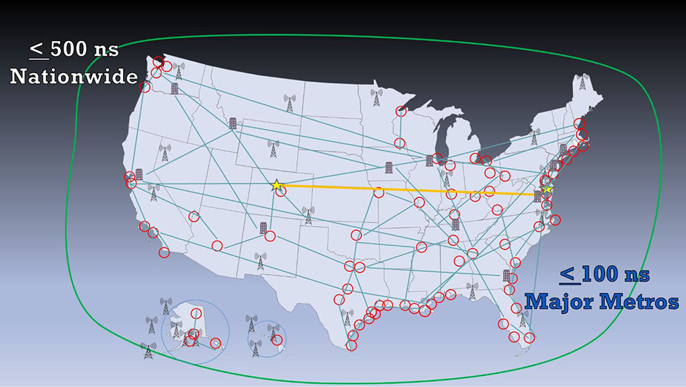
In a report issued on Jan. 14, the Department of Transportation (DOT) outlined the results of its GPS Backup Technology Demonstration project. As officials had previously projected, it called for a system-of-systems approach using multiple complementary technologies.
The report called for an architecture that included signals from space in the L-band, terrestrial broadcasts in the ultra high frequency (UHF) and low frequency (LF) spectra, and a fiber backbone to synchronize and feed precise time to terrestrial transmitters.
The demonstration project and report were mandated by Congress in legislation passed in late 2017 and funded in early 2018. Delays within the administration resulted in the project beginning in early 2019.
Monty Johnson of OPNT demonstrates precise time transfer through 100 kilometers of spooled fiber-optic cable. (Photo: RNT Foundation)
Demonstrations
Of 21 firms that offered to demonstrate their wares, 11 were selected. They were:
Echo Ridge LLC and Satelles Inc. Satellite-based PNT technologies using the S and L bands, respectively.
OPNT B.V. and Seven Solutions S.L. Fiber-optic time transfer using the White Rabbit Precision Time Protocol technology.
TRX Systems Inc. Dead reckoning technology with inertial measurement units and localized map matching supplemented with ultra-wideband beacons.
Hellen Systems LLC and UrsaNav. eLoran that uses LF transmissions.
Serco Inc. Medium frequency R-mode.
NextNav LLC. Metropolitan beacon system using UHF frequencies.
PhasorLab Inc. and Skyhook Wireless Inc. Both use Wi-Fi frequencies. Phasorlab uses a dedicated network of transmitters. Skyhook leverages existing Wi-Fi access points.
Five of the demonstrations were conducted at Joint Base Cape Cod, with the remainder at NASA’s Langley Research Center in Virginia.
Timing demonstrations were assessed for system:
coverage (service availability) within an “appropriate area” (wireless systems only)
accuracy and stability across an appropriate area
long-term accuracy and stability of time transfer to a fixed location
time transfer availability and accuracy to a fixed location under challenged GPS signal conditions.
Positioning was evaluated for:
coverage within a defined region
2D and 3D dynamic positioning service availability and accuracy
availability and accuracy of static positioning
long-term availability and accuracy of static positioning
long-term availability and accuracy of static positioning under challenged GPS signal conditions
DHS work referenced
The report also mentions an earlier set of demonstrations done by the Department of Homeland Security (DHS).
In December 2018, DHS’s Science and Technology Directorate performed the work through the Homeland Security Systems Engineering and Development Institute. The project “demonstrated a combination of position and timing use cases for dynamic vs. static and indoor vs. outdoor applications, along with a time-transfer use case for critical infrastructure applications.” Systems from Locata Corp, NextNav, and Satelles were evaluated.
The DoT report says that eLoran was not part of the DHS effort because of the lack of transmitters in the area. However, “DHS had previously studied eLoran performance under a Cooperative Research and Development Agreement (CRADA) with Harris Corporation and UrsaNav and had an understanding of its capabilities.”
A report of DHS’ December 2018 work is not publicly available, though DOT says it was used to inform their efforts.
The 437-page DOT report is filled to the brim with detailed information about the project, individual technologies, and demonstration results.
The Executive Summary says that, in addition to the findings from the DHS December 2018 effort (which were not listed), the DOT demonstration had four key findings:
All TRL-qualified vendors offered showed PNT “performance of value” and one showed value in all scenarios.
Neither eLoran company succeeded in the Static Basement Timing scenario.
R-mode ranging did not meet the minimum technical readiness level (TRL) of 6.
Deployment effort and coverage (infrastructure per unit area) are significant cost factors.
Addressing the needs of critical infrastructure owners and operators, the report concluded the needed “technologies are LF and UHF terrestrial and L-band satellite broadcasts for PNT functions with supporting fiber optic time services to transmitters/control segments.”
Reactions and way forward
Government officials and industry observers alike have welcomed the report, though it does leave some questions on the table.
One is about other national PNT needs. The congressional tasking was to report on GPS backup technologies for critical infrastructure and national security. The Jan. 14 report focuses on critical infrastructure needs. Information on national security requirements, some of which is classified, was provided to Congress separately by DHS and the Department of Defense.
“Economic and homeland security are sometimes considered by agencies and Congress as subsets of national security, sometimes not,” according to one analyst. “So, we don’t know if the needs of first responders, delivery services, civil government agencies, and other essential users were ever formally considered. The good news is that the combination of systems identified, if implemented and made available to all, would likely meet the needs of most.”
Other open issues are about implementing the report’s recommendations.
Some have been quick to point out that the demonstrations were to inform the government, not part of a procurement.
“If this was for an acquisition, it would have been done differently,” said one government retiree. “Rather than having vendors set up and operate the equipment, government evaluators would have been much more hands on. And they would have made every effort to do all the trials at the same location.”
Going forward, cost will also an important factor, as mentioned in the report’s key findings. “Depending on who you want to serve and where, the costs of different technologies vary by orders of magnitude,” said one provider.
Reaction from those involved with the demonstration project has been generally upbeat with praise for DOT’s effort and anticipation of more progress.
Typical were comments from Ganesh Pattabiraman, CEO at NextNav, who appreciated the real-world scenarios DOT used in the project. Regarding next steps he said, “We look forward to working with Congress on implementing the report’s recommendations.”
A new white paper sponsored by the Resilient Navigation and Timing Foundation (RNT Foundation) discusses the need and implementation of a reliable and resilient national timing architecture that will include space-based assets. This system-of-systems architecture — GNSS, terrestrial eLoran broadcasts and fiber — is essential to underpin today’s technology and support development of tomorrow’s systems, according to the executive summary of A Resilient National Timing Architecture.
“Everyone in the developed world needs precise time, all the time, whether they know it or not,” said Marc Weiss, one of the paper’s authors and an internationally recognized expert on timing and synchronization. “It is a foundation of every networked technology, digital broadcast, and most navigation systems, to name just a few critical uses.”
Three Paths to Precise Time
“Precise time is so important that everyone needs at least three independent methods of getting it. So, if one, or even two, fail it is not a national disaster,” said Pat Diamond, co-author of the paper. “Our proposed architecture calls for precise time via GNSS, terrestrial eLoran broadcasts and fiber.” Diamond is a long-time network designer, developer, and entrepreneur. He is also a member of the U.S. National Space-Based Positioning, Navigation, and Timing Advisory Board.
Diamond also pointed out that these three methods should be the backbone for timing distribution in the U.S., but won’t be the only methods. “What we are describing is a baseline architecture that will be added to,” he said. “It is a starting point. We envision in the paper additional distribution methods like time from other satellites, user clocks, and so on, all being part of the mix.”
Government Leadership
The U.S. federal government has a leadership interest and responsibility in all of this, according to the paper. Nations have long recognized the military and commercial advantages of determining and distributing precise time. Great Britain’s Longitude Act of 1714 was really about developing a chronometer to support safe navigation of Royal Navy and British merchant fleet. In the United States, the U.S. Naval Observatory has been keeping and distributing a national time scale time since 1845.
“Just because the feds have an important leadership role, doesn’t mean they have to build and own a bunch of systems,” said Dana A. Goward, the paper’s third co-author and executive director of the RNT Foundation. “There are a variety of ways these systems can be established. Public-private-partnerships, subscription contracts like the FAA did with their air traffic ADS-B system, and cooperative agreements are all examples. As we move forward with 5G telecommunications and perhaps even timing and navigation, it will be increasingly important to have a rock solid timing infrastructure to support it all.”
The National Timing Resilience and Security Act of 2018 requires the U.S. Department of Transportation to establish a terrestrial system to backup GPS timing services by December of this year. While the department does not appear to be on track to meet that goal, it completed a technology demonstration program for GPS backup technologies earlier this year. Two companies demonstrated timing distribution by fiber. Another two demonstrated eLoran.
Many Pieces Already in Place
One of the benefits of the proposed architecture is that much of what is called for is already in place, according to the paper. “We already have fiber networks, NAPs (network access points). eLoran is mature and has been deployed by the Brits. And the U.S. government owns enough former Loran-C sites to establish a nationwide eLoran network,” Diamond said. “All we need is a bit of money and some engineering work to put this all together.”
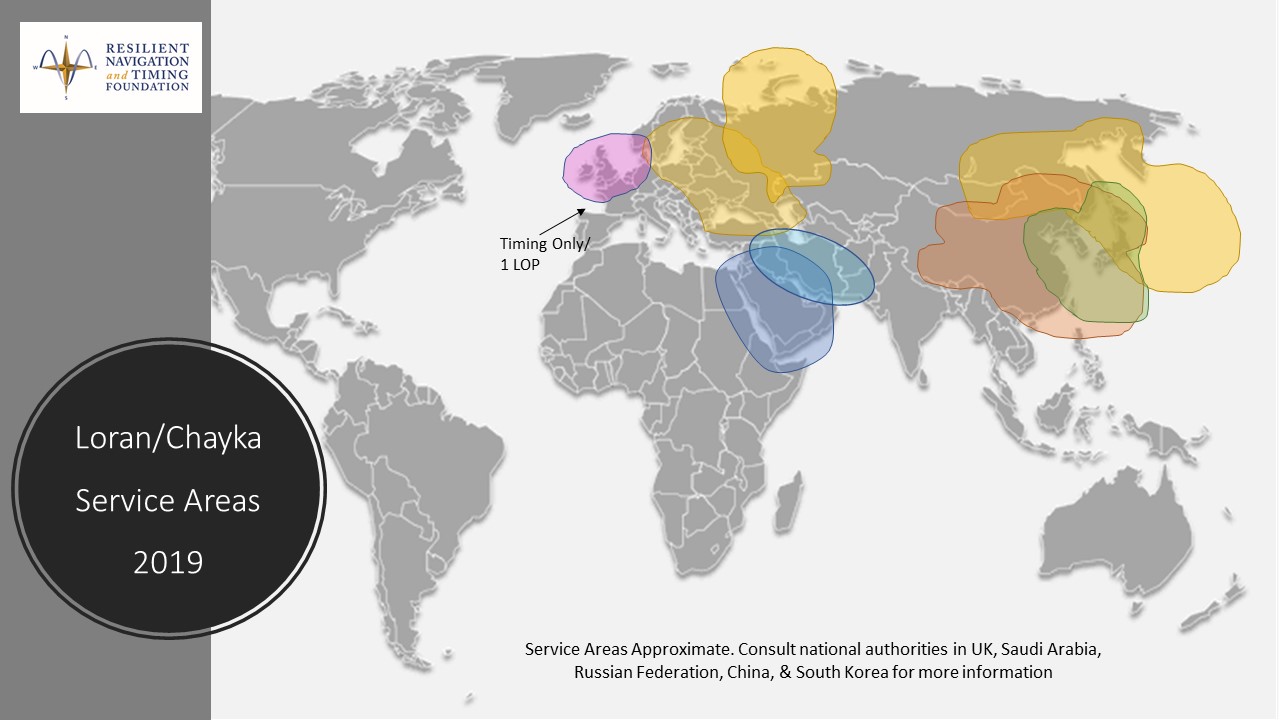
An August 2020 paper published by the journal Sensors revealed China’s plans to expand coverage of its terrestrial Loran positioning, navigation and timing (PNT) system with three new transmitter sites in the western part of the country. The article indicates that this is a part of providing a backup system for GNSS.
According to the paper, “…the vulnerability of GNSS to unintentional and intentional interference signals can be found frequently nowadays. For national security and economic effectiveness, a reliable and complementary navigation system is needed desperately. The suitability of the Loran for a backup navigation system has been evaluated and reported.”
China has operated a Loran system for decades. While the system is capable of operating independently, its signals are also compatible with systems operated by South Korea and Russia. These are coordinated through the Far East Radio Navigation Service (FERNS) to ensure the systems are complementary and reinforce each other where coverage overlaps. The United States and Japan were also members of FERNS until they terminated Loran transmissions in 2010 and 2015, respectively.
Image: RNT Foundation
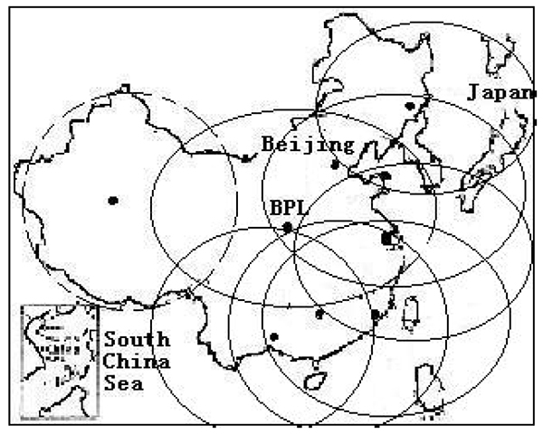
Little public information about China’s Loran system has been available and our queries have gone unanswered. One of the few documents available in the west is a 2014 paper about Loran-C from the Chinese Academy of Sciences in Shaanxi, China which can be accessed through the RNT Foundation website. It shows substantial Loran coverage in the eastern part of the nation, but only a broken circle indicating “projected coverage” in the west.
Graphic from 2014 Chinese Academy of Sciences paper on Loran showing projected coverage in the western part of the country with a dotted circle. (Image: RNT Foundation)
The single transmitter in that area projected by the 2014 paper could provide a strong, difficult to disrupt timing signal for fixed receivers with known locations.
Three new transmitters will be installed according to the August 2020 paper titled “High-Accuracy Positioning Based on Pseudo-Ranges: Integrated Difference and Performance Analysis of the Loran System.” The increased service in the western part of the country will provide “full coverage” positioning, navigation and timing usable by both fixed and mobile receivers.
The August 2020 paper is the first known documentation in over a decade of specific Chinese intentions regarding its Loran system.
Still, it is not a surprise to many observers. At 2019’s Stanford PNT Symposium, Xiaochun Lu of China’s National Time Service Center described the nation’s plan for a “comprehensive” PNT system. This system will include a wide variety of PNT sources including low earth orbit satellites, inertial systems, local positioning systems, and Loran.
Like Ms Lu, the authors of the August 2020 paper are employed at China’s National Time Service Center, which is part of the Chinese Academy of Sciences.
News from the British government appears to be a part of the United Kingdom’s diversification away from primary reliance on GNSS for positioning, navigation and timing (PNT) services, and toward a more diverse set of sources.
The nation has previously undertaken establishment of a National Timing Centre for distribution of time from suites of atomic clocks and has long transmitted an eLoran timing signal from a government facility in Anthorn.
Thursday’s press release, titled “Government to explore new ways of delivering ‘sat nav’ for the U.K.,” reinforces the government’s commitment to space-based PNT, but not necessarily from GNSS.
OneWeb satellites
The announcement follows significant criticism in Parliament of the nation’s purchase of a 45% share of the bankrupt communications satellite company OneWeb, with the India’s Bharti Holdings having the majority stake. OneWeb had 74 of its planned 648 satellites in orbit when it declared insolvency. With new ownership and financing in place, it plans to resume operations and launch another 36 satellites in December.
Prime Minister Boris Johnson’s motivation for making the investment was to offset Britain’s post-Brexit exclusion from Europe’s Galileo system. The idea was that OneWeb assets in low earth orbit (LEO) could provide a global British PNT capability.
This concept faced political and technical opposition from the start. Many technologists in the U.K. and elsewhere doubted that the constellation could be easily adapted to provide sufficiently accurate PNT services. The doubts were so serious that the senior career civil servant responsible for signing the agreement to invest in OneWeb took the very unusual step of refusing to do so without written direction from the political appointee she worked for.
Before the OneWeb investment, the U.K. government had been studying establish of its own GNSS like America’s GPS and Europe’s Galileo. Sources say the required investment was much higher than the nation wanted to make and would provide little added capability beyond that available from extant systems.
According to Thursday’s press release, the UK GNSS effort was exploratory and will end this month. It will be “reset” as the Space-Based Positioning Navigation and Timing Programme (SBPP). This project “will explore new and alternative ways that could be used to deliver vital satellite navigation services to the United Kingdom which are critical for the functioning of transport systems, energy networks, mobile communications and national security and defence, whilst boosting the British space industry and developing the U.K.’s own capabilities in these services.”
While the press release is short on detail, it does mention satellites at low earth orbit and that “a wider range of options” will be examined. This could suggest redoubling efforts on getting PNT from OneWeb, and/or investing in regional PNT satellites.
Galileo again?
The press release also says SBPP will “consider collaboration with international allies to share satellite navigation services, costs and technology.” This may signal reengagement with Europe on involvement with Galileo.
Some observers have said that Brexit did not have to automatically mean that the U.K. was excluded from the Galileo project. European Union membership is not required for participation in the European Space Agency which is responsible for Galileo. Switzerland and Norway, for example, are not EU members, but are members of ESA and sit on its governing board.
The U.K. government has been very concerned with PNT and GNSS vulnerability since at last 2012 when large solar flares became part of its National Risk Register. In 2017 a London Economics Report found that a five-day GNSS disruption would cost the nation more than $1.3B per day.
This most recent announcement indicates that Britain is still intent on going its own way and diversifying PNT sources, while still acknowledging the ongoing importance of GNSS and keeping its options open with allies.
Dana Goward is president of the Resilient Navigation and Timing Foundation. He is the proprietor at Maritime Governance LLC. In August 2013, he retired from the federal Senior Executive Service, having served as the maritime navigation authority for the United States. As director of Marine Transportation Systems for the U.S. Coast Guard, he led 12 different navigation-related business lines budgeted at more than $1.3 billion per year. He has represented the U.S. at IMO, IALA, the UN anti-piracy working group and other international forums. A licensed helicopter and fixed-wing pilot, he has also served as a navigator at sea and is a retired Coast Guard Captain.
Recent completion of China’s BeiDou satellite navigation system has rekindled privacy and security concerns among some in the West. China has incorporated a two-way messaging capability into BeiDou that many fear will be used to track individuals and install malware on user devices.
Most satellite navigation experts view such concerns as far overblown.
At the same time, though little discussed, BeiDou’s completion does signal a new phase for China’s status as a world power and its ability to challenge the West on many fronts.
Two-way communications
It is possible for specially equipped receivers to communicate back to the BeiDou constellation. But this is not true for the vast majority of receivers (including those in cell phones). Industry experts say that all mass market chips for every GNSS system, including BeiDou, are “receive only.” Only specially equipped devices will be able to take advantage of its two-way communications capability, and it should be quite apparent to users when it is in operation.
Users, they say, should be much more concerned about location privacy and security issues that have been around for decades. Mobile phones have long reported user locations through the cellular network based upon information derived from GPS, WiFi ranging and other position calculations. The ability to hack and compromise a cell phone or other receiver will not be affected by the addition of BeiDou as a receive-only location source.
It is also important to note that using specialized equipment for two-way communication with a Global Satellite Navigation System (GNSS) is not something new to BeiDou. While the Chinese system may have improved upon the capability, users with the right equipment can send messages using the Search and Rescue functions to the United States’ GPS, Europe’s Galileo, and Russia’s GLONASS.
China has risen
Completion of BeiDou, unquestionably a significant technical achievement, does signal a significant step up for Chin’s status as a world power and influencer. It is a declaration of technical independence from the West with wide ranging geo-political impacts.
“(1) address national security requirements by ending military reliance on GPS;
(2) build a commercial downstream satellite navigation industry to take advantage of the quickly expanding market; and
(3) achieve domestic and international prestige by fielding one of only four such global navigation satellite systems (GNSS) yet developed”
Military Power and National Security. The Chinese military has long sought its own GNSS. This was amplified during a crisis in 1996 when it fired three missiles toward Taiwan as a warning. One struck the sea about 11 miles from a Taiwanese military base, but the other two disappeared. China claims that the United States interfered with GPS signals and was to blame. The Chinese military was both horrified and humiliated.
Having a sovereign GNSS eliminates the problem of relying on the U.S., Russia, or Europe for satellite navigation. That it is the world’s newest system also certainly has its advantages. China has undoubtedly incorporated state of the art anti-jamming and anti-spoofing capabilities into the version of BeiDou used by the military. After decades of observing others interfering with GNSS signals, and doing a fair bit of it on their own, it would be hard to imagine Chinese engineers not including the latest resilience features.
An operational BeiDou also means that China’s military is much freer to interfere with GPS and other GNSS in pursuit of tactical and strategic advantage without endangering its own services and infrastructure. It is likely that the levels of jamming and spoofing seen near the Spratley Islands and mainland ports will increase. Even if they do not, the increased possibility of Chinese interference will add yet another degree of complexity and uncertainty for western military forces.
Economic Power. The technological and commercial benefits of BeiDou for China are unquestionably substantial as well. Direct benefit from the manufacture and sale of equipment, plus spinoff industries and technologies, add to an already impressive national technology and economic portfolio. This is especially true since positioning, navigation, and timing (PNT) services are a “silent utility” underpinning so many network and other technological systems. The huge domestic market and robust overseas sales continue to grow (by 20% per annum according to Chinese reports) providing huge returns.
Prestige and Soft Power. “BeiDou launch marks China’s rise to ‘major space power’” read a recent headline in the Asia Times. This is perhaps understated as, with BeiDou complete, there is, technologically, little the West has achieved that China has not equaled. This has greatly enhanced China’s global standing and made it, in the eyes of many in the developing world, an ally and provider as good or better than the U.S. or Europe.
And China is eager to share its new PNT utility with others to further, not just its economy, but more importantly its long-term strategic interests.
Forsaking GPS
Regionally, China has been encouraging neighbors to adopt BeiDou for national PNT and forsake GPS. As one example it provided Thailand with nearly $300M in foreign aid targeted to promoting BeiDou use by Thai government organizations.
Writing in July in The Diplomat, Dr. Namrata Goswami observed
“… BeiDou is located within China’s ‘Information Silk Road,’ a subset of its land and maritime silk routes under the Belt and Road Initiative (BRI). China is now able to extend influence in a multidomain environment (land, sea and space) via its BeiDou space system, which provides navigation to aircraft, submarines, missiles, as well as commercial services dependent on such navigation. China’s Ministry of Industry and Information Technology sells the Information Silk Road, to include BeiDou and 5G networks, to global audiences as a completely self-sufficient technology infrastructure that anticipates life in the 21st century.”
This extends China’s influence through BeiDou even farther and has led a number of nations to seek closer ties with China through BeiDou.
Mohamed Ben Amor, secretary general of the Tunisia-based Arab Information and Communication Technology Organization, an organization of the Arab League, told GPSDaily.com, “Cooperation on the BDS is of special significance for the Belt and Road construction…The next step of the China-Arab cooperation is to achieve further connectivity and both sides can apply the BDS to promote regional technological and economic development.”
Iran’s view
Iran has had a Memorandum of Understanding with China about BeiDou since 2015. It provides for BeiDou ground stations in Iran, access for Iran to high-precision services, and establishment of an Iranian center for space data collection.
And In a tweet last week Iran’s Ambassador to China cited BeiDou’s completion as the “…end to the monopoly of the U.S.’s GPS.” He said, “There is great potential for aerospace cooperation with China,” and went on to suggest that Iranian aerospace students could work as a bridge between the two countries.
Similar comments have been published from entities in India, Indonesia, Malaysia, and throughout Southeast Asia.
China is indeed to be congratulated for a significant achievement with the completion of BeiDou. Even more noteworthy, though, is how it has integrated BeiDou seamlessly into its national plans for technology, economic, military and diplomatic efforts — a comprehensive, coordinated program to boost its standing in the world, especially relative to the United States and Europe.
Dana Goward is president of the Resilient Navigation and Timing Foundation. He is the proprietor at Maritime Governance LLC. In August 2013, he retired from the federal Senior Executive Service, having served as the maritime navigation authority for the United States. As director of Marine Transportation Systems for the U.S. Coast Guard, he led 12 different navigation-related business lines budgeted at more than $1.3 billion per year. He has represented the U.S. at IMO, IALA, the UN anti-piracy working group and other international forums. A licensed helicopter and fixed-wing pilot, he has also served as a navigator at sea and is a retired Coast Guard Captain.
Last week, 27 members of the U.S. House Agriculture Committee sent a letter to Federal Communications Commission (FCC) Chairman Ajit Pai. In it, they urged him to reconsider the FCC’s decision to allow Ligado Networks to operate a terrestrial nationwide network that the executive branch says will cause harmful interference to GPS signals for many users.
This concern and opposition from a sector not traditionally engaged in GPS or positioning, navigation and timing (PNT) issues is just one example of how the FCC’s decision — rather than putting the issue to rest — has instead recruited a whole new set of actors from across multiple sectors for the opposition.
Many observers don’t see this as surprising.
According to one observer, previously it was easy for many to assume the FCC would reject Ligado’s proposal. The entire executive branch had been vehemently opposed for years. So had aviation groups, the weather community, geospatial interests and some satellite communications concerns. With such opposition from so many important quarters, it was reasonable for many to assume they need not become involved. Now that the FCC has acted to the contrary, these interests have become well energized.
The FCC decision also empowered opponents to educate and recruit others who don’t normally think or worry about GPS and PNT issues, folks like farmers and agricultural interests.
As one insider said, “The existing opposition can now go to just about anyone in any sector and say, ‘This is going to happen and it will harm your operation. There are no ifs, ands, or buts. The FCC has decided’.”
Photo: Avalon_Studio/E+/Getty Images
Agriculture’s reliance on GPS
Agriculture is a good example. While not the sector that first springs to mind when most people think about GPS, farming has become dependent on augmented GPS for precisely and automatically driving machinery, minimizing fertilizer and pesticide use, and a wide variety of other productivity gains over pre-GPS operations.
“GPS is critically important to the commercial agriculture, mining, forestry and rural manufacturing industries. In fact, GPS has become the single most significant technological advancement for American farm equipment in the past two decades… [A 2019 RTI study] found that during planting season, if GPS were interrupted, the economic impact to the agriculture sector could amount to losses of $15 billion due to lower crop yields. Moreover, an earlier study suggested GPS-enabled precision agriculture could save farmers an estimated 10 to 15 percent in operating costs and purchased inputs. This same study estimated the benefits of GPS to precision agriculture between $10 and $17 billion.”
Department of Transportation studies have shown that high-precision GPS receivers, such as those used in agriculture, could be impacted within 3,000 meters of a Ligado transmitters. With tens of thousands of transmitters deployed in a nationwide network, this could pose a real problem for American farming.
Other sectors have also become involved in the opposition. The recently formed Keep GPS Working Coalition has members representing aviation, surface transportation, maritime, agriculture and equipment manufacturing.
This formal and public coalition, though, seems to be just the tip of the opposition iceberg.
Almost 100 dissenting organizations
According to some involved with protesting the FCC’s decision, there are nearly a hundred organizations and companies that are working in some way to have it overturned. These include multiple aviation, delivery service, agriculture, surface transportation, geospatial, weather, maritime, space and technology interests.
One sign of the influence they are having is an increase in concerns being expressed by members of Congress.
In addition to the agriculture letter, some of the most powerful recent examples are statements made during meetings of the influential House Committee on Appropriations. Rep. Ken Calvert (R-CA), ranking member of the Defense Appropriations subcommittee, spoke at length in opposition to the FCC’s action. His comments were followed in a similar vein by the vice chair of the Appropriations Committee, Rep. Peter Aguilar (D-CA).
Many of the questions being asked by the public and members of Congress alike were reflected in the letter from the Agriculture Committee members:
How did the FCC know that “its” tests were representative and valid?
Why does the FCC find that some degradation of GPS reception is acceptable?
Why did the FCC reject the executive branch’s testing criteria?
Was there a cost/benefit analysis?
The letter also asked the question that is on almost everyone’s mind: If and when there are problems, who is going to fix them?
Not surprisingly, the primary topic at the July 1 meeting of the National Space-based Positioning, Navigation and Timing Advisory Board was the Federal Communications Commission (FCC) decision on Ligado Networks.
In it Captain Sullenberger cited many of the issues the board’s vice chair, Brad Parkinson, discussed later in the meeting. Sullenberger’s statement is available here.
In his presentation, Parkinson called the FCC decision “a grave error.” He outlined his rationale in 21 information-packed slides.
Parkinson summarized his presentation up front with three points:
Repurposing the Mobile Satellite Services (MSS) radio spectrum is very high risk and brings virtually no near-term benefit to the United States.
The risks affect much more than the Department of Defense: high-value civil applications are also in jeopardy.
Any such repurposing should have been subject to a formal rulemaking process.
At the end of the presentation, the board voted unanimously to adopt the presentation, with slight modifications, as a reference document for posting on the board’s website.
The group had previously made strong recommendations to the Departments of Defense and Transportation to oppose any such action by the FCC. Both departments have done that and are continuing to do.
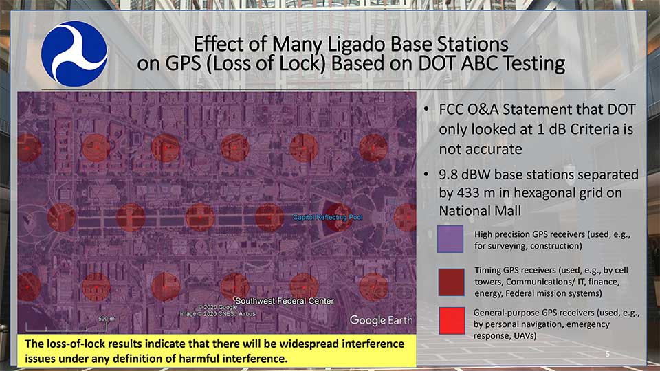
Hazardous information versus losing lock
One slide in Parkinson’s presentation included a Department of Transportation (DoT) depiction how of Ligado transmissions would cause several types of receivers to “lose lock.” This graphic was used in a recent DoT presentation to the FCC.
DOT briefing to FCC: “Concerns Over Ligado Order & Authorization,” June 2020. (Slide: DOT)
Heretofore DoT has usually discussed the points at which Ligado transmissions would cause a 25% increase in the noise floor for receivers. This is an important metric as tests have shown that beyond that point many receiver types begin to give hazardously misleading information. DoT officials have used the example that the 1dB limit is like putting a load limit on vehicles crossing a bridge so that the bridge never reaches its breaking point. An important consideration with a safety-of-life application like GPS.
The National Space-Based PNT Advisory Board. (Board photo)
A receiver often gives inaccurate positioning and timing data, possibly hazardously misleading information, before it “loses lock” and stops providing any information at all. It is more difficult for a receiver to “acquire lock” than to track satellites and provide information, so equipment is rarely able to function again until it moves out of the area of interference.
When asked why DoT would bother to show such information to the FCC, one official suggested that loss of lock was more in line with the criteria the Commission used in making the Ligado decision. The hope was that, by showing that even this flawed standard had significant impacts which the FCC perhaps did not fully recognize, further technical discussions and reconsiderations could be realized.
Other Topics
While discussion of the FCC’s decision took the most time in the on-line meeting, several other issues were discussed as well.
Colonel Curtis Hernandez from the National Security Council briefly described development of a new space-based PNT policy to replace NSDP-39 which was put in place by President Bush in 2004.
He was not able to provide any specifics as it is a draft and still under consideration. Answering a question, he did say that the draft policy outlined the responsibilities of various departments, including for interference detection and monitoring.
Adam Balkcum from the Office of Science and Technology Policy discussed his office’s nascent efforts to investigate non-GNSS PNT as directed by the recent Executive Order on Responsible Use of PNT. The question of whether this includes possible PNT services from low earth orbit and geostationary satellites remains an open one.
Other presenters included:
Seth Jonas of the National Security Council staff on the recent Executive Order on Responsible Use of PNT,
Andrew Hansen of the Volpe Transportation Systems Center who spoke about efforts to monitor for GPS interference, especially in the post-FCC Ligado decision environment, and
NASA’s Chris Bonniksen discussed issues with operating and funding the agency’s Global Differential GPS system.
The agenda for the meeting and presentations are available here, as will be the meeting minutes once they have been finalized.
In 2018 the first-ever European Radionavigation Plan said “It is recognized that [..] GNSS should not be the sole source of PNT information. Alternative PNT systems, not necessarily using radio frequencies, should thus be put in place where the criticality of the application requires it.”
Graphic from MarRINav report showing system of systems approach to PNT resilience and reliability. (Image: Resilient Navigation and Timing Foundation)
In 2019 the European Space Agency (ESA) published a permanent open call for proposals for positioning, navigation, and timing studies and systems, including those that had nothing to do with space.
“Maritime navigation and port operations are critical for almost every nation,” said Jonathan Turner, one of the MarRINav project team. “As an island nation with a strong maritime heritage, we in the United Kingdom perhaps have an even greater appreciation of this.” Turner is co-founder of the blue economy solutions company NLA International, which led a team of eight organizations cooperating on the project.
While MarRINav focused its analysis on the United Kingdom, the intent was to provide information, and an analysis framework, that could also be used by other nations.
Maritime is one of sectors most dependent upon GNSS, according to the project reports, and a sector with great awareness of GNSS vulnerabilities and their consequences. MarRINav concludes that integrity and resilience are two of the most important parameters for maritime navigation.
Maritime is also one of the sectors most ready to integrate space and terrestrial navigation systems, according to the report’s authors. The International Maritime Organization has already introduced a performance standard for a multi-system receiver, or MSR, that will incorporate a wide variety of navigation signals.
Despite the distractions of Brexit over the last four years, the United Kingdom has been particularly focused on its vulnerability to GNSS outages.
In February of this year the UK government announced it was establishing a virtual National Timing Centre to protect the nation from the risk of GNSS failure, and in March the final MarRINav report was published.
Among the project’s findings are that:
The United Kingdom needs a comprehensive maritime PNT architecture with multiple, diverse sources to ensure continuity of maritime operations
Such a “hybrid solution” could benefit other sectors, especially if non-maritime needs were considered early in the design
New PNT systems should be terrestrial and sovereign
Establishing such a system for the UK has a very positive benefit to cost ratio
Important aspects of the new architecture are E-GNSS (Galileo and EGNOS), Enhanced Loran (eLoran) and the Ranging Mode (R-Mode) of the VHF Data Exchange System (VDES), and complemented by the development of a specific Maritime Receiver Autonomous Integrity Monitoring (M-RAIM) algorithm.
LOCATA or a similar local positioning system should be implemented at UK ports to provide a backup for container operations.
Satelles Satellite Time and Location may have potential, but its utility has yet to be demonstrated for maritime.
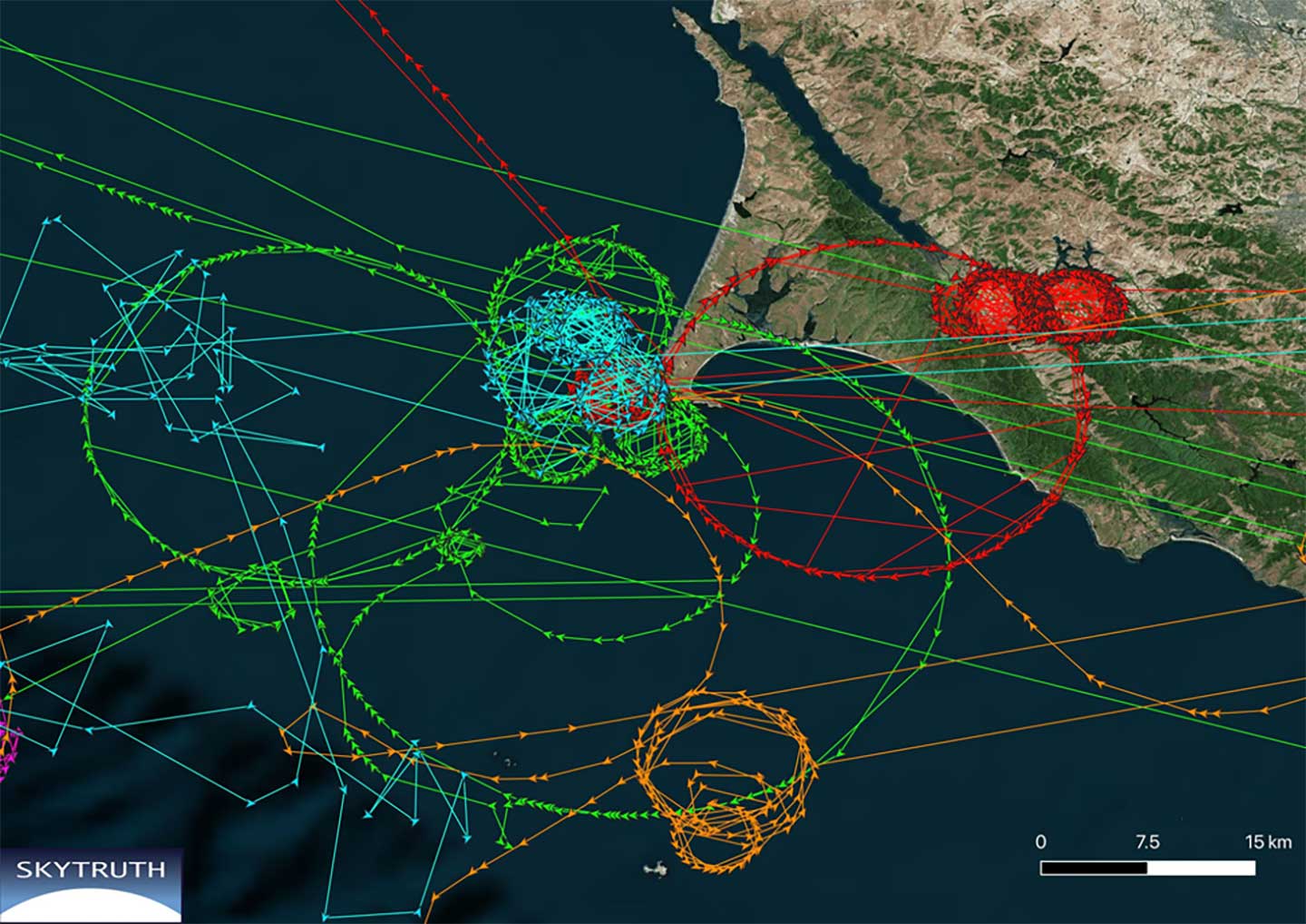
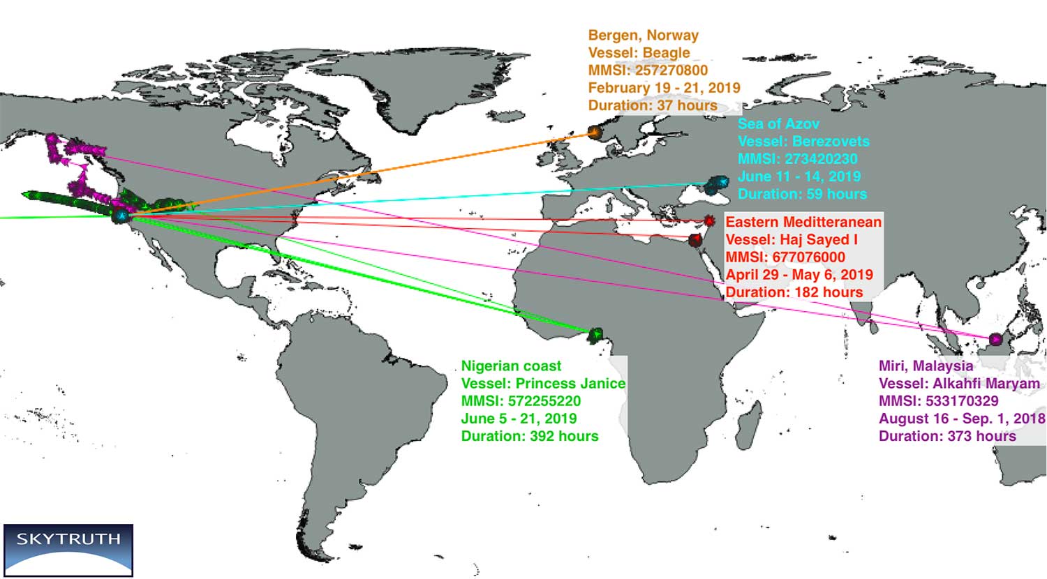
New research by Bjorn Bergman of the environmental non-profit SkyTruth has found ships in various parts of the world reporting locations thousands of miles away and circling at precisely 20 knots.
Bergman’s findings were first reported at the annual meeting of the Resilient Navigation and Timing Foundation on May 5.
Bergman previously observed and reported on circling phenomena with GPS-based reporting systems from vessels and fitness trackers in China ports. It has also been observed in Tehran, Iran. In all those cases, though, it was clear that the real location was fairly nearby the false and circling locations.
In the most recent observations, the actual locations of the ships were thousands of miles away. In most cases, literally halfway across the globe.
Image courtesy of Skytruth and RNTF.
Bergman said that he was able to verify the vessels’ approximate true location by examining the field of view of the satellite receiving the automatic identification system (AIS) position reports. The satellites are only able to see an area about 5,000 kilometers wide.
A satellite that could only see the Gulf of Guinea in West Africa, for example, received GPS-based location data from a ship’s AIS that showed the vessel offshore of Point Reyes in northern California. The vessels’ true locations were also confirmed by their position reporting before and after the “displacement events.”
Bergman was unsure if these errors are the result of the ships’ AIS systems or some fault or influence on GPS navigation receivers. It is clear that ongoing “circling” incidents in China are some form of GPS interference.
GPS-based fitness tracker reporting was affected the same way and at the same time as those of receivers on vessels. Bergman has been able to find no similar supporting data for these long-range displacement and circling events.
While Bergman was able to observe these events, he was at a loss to explain them. In previously observed cases it seemed clear a disruption device was nearby and affecting a large number of vessels. In these incidents, each vessel was the only one in its vicinity affected, and the vessels were separated by thousands of miles.
Image courtesy of Skytruth and RNTF.
Further hampering analysis, and making even speculation difficult, was the lack of commonality among the few cases observed.
The vessels were of much different types and operations. Pilot boats, work boats, tugs, cargo and passenger vessels were all involved.
The length of these disruptions also varied greatly. The shortest recorded was a reefer ship for less than half an hour. A crew boat was “displaced” for more than 16 days.
While most of the vessels reported circling positions off the coast of Northern California, two were displaced to Madrid, one to the vicinity of Hong Kong, and one to the Chinese city of Shanwei. One even began reporting it was circling a location offshore of northern California, and subsequently reported circling positions that drifted east almost a thousand miles inland to Utah.
A true mystery, the RNT Foundation is hoping to crowdsource ideas and share them with Bergman and other analysts. Anyone with insights or ideas about this mystery is encouraged to send them to [email protected].
A video of Bjorn Bergman’s presentation at the RNT Foundation’s annual meeting is available on the foundation’s website and below. He has also posted a short paper on these events on SkyTruth’s website.