Tag: Dana Goward

  • GPS circle spoofing discovered in Iran

    GPS circle spoofing discovered in Iran

    In March, the U.S. government received an unusual inquiry about GPS disruptions. It was from a user in Iran reporting what appeared to be “circle spoofing” — a phenomenon that had only previously been observed in China.

    “Some of GPS devices received fake signal and show the fake valid location. Yesterday I test a device, it can get signal and give real position. After 10 minutes the device show moving around a big circle in tehran by 35 km/h speed. I can’t fix this problem by restarting the device.

    “The GPS module time is correct but the location is not. I attach Excel file of data and map of the track. I can’t get any response from Communications Regulatory Authority (CRA) of The I.R. of Iran. Do you know about this?”

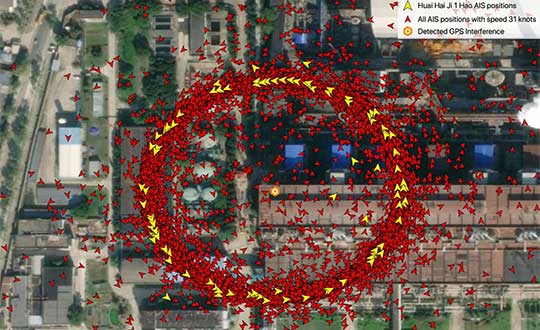
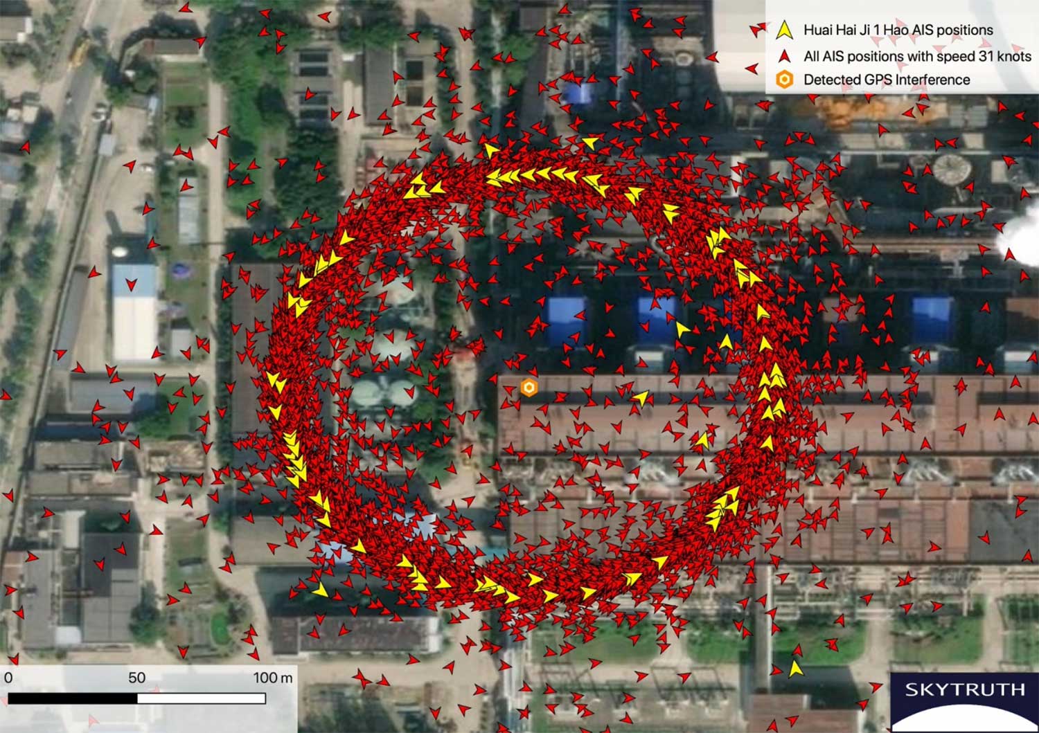
    Here is one of the images provided by the reporting source:

    GPS spoofing device in operation at Iran’s Army Command and Staff College. (Screenshot: Dana Goward)
    GPS spoofing device in operation at Iran’s Army Command and Staff College. (Screenshot courtesy of Dana Goward)

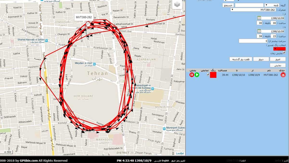
    A little internet research showed that the spoofing was taking place at or near Iran’s “AJA University of Command and Staff,” formerly called the “War University.” It is the staff college for Iran’s Army.

    Reports to the U.S. government about GPS disruption are normally listed on the U.S. Coast Guard’s Navigation Center website. This one has not been posted. Coast Guard officials said that it is because the report was received by another agency and did not contain sufficient information. Attempts by Coast Guard personnel to contact the reporting source for more information to enable the report to be posted were unsuccessful.

    GPS spoofing is often easiest to detect in maritime areas. Ship automatic identification system (AIS) transmissions include location data and are detected by satellite. The data is then aggregated and used by various companies for a number of applications. Viewing ship location reports over time has revealed thousands of ship receivers spoofed to airports in Russia, and hundreds spoofed into circles (presumably around the spoofing device) in China.

    Clearly, though, any system that aggregates and displays GPS location data can help detect wide area spoofing activity.

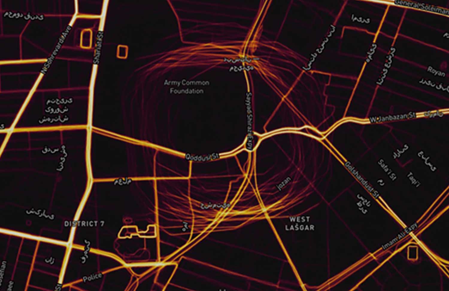
    Strava is a mobile app for runners and cyclists. The company aggregates location data and displays it on a heat map to highlight athletes’ favorite routes.

    The Strava heat map for Tehran shows that circle spoofing has also been employed in at least one other location. The below screenshot shows GPS-enabled fitness trackers circling a government complex that houses offices for several defense and technology-related organizations.

    This heat map shows GPS spoofing at a government complex in Tehran,which houses the Ministry of Defense, Communication Regulatory Authority, Telecommunications Infrastructure Company, and Ministry of Telecommunications and Technology. (Screenshot: Dana Goward)
    This heat map shows GPS spoofing at a government complex in Tehran,which houses the Ministry of Defense, Communication Regulatory Authority, Telecommunications Infrastructure Company, and Ministry of Telecommunications and Technology. (Screenshot: courtesy of Dana Goward)

    Iran was the first nation to publicly announce it had the ability to spoof GPS signals and seems to have used it to great advantage.

    In 2011, a CIA drone that had been operating across the border in Afghanistan landed at an Iranian airfield. Iran’s government claimed that its forces had sent false signals to the drone’s GPS receiver in order to capture it.

    At first, U.S. government officials said that this kind of spoofing was not possible. Several months later, Prof. Todd Humphreys demonstrated how it could be done to a drone at the University of Texas football stadium.

    U.S. officials then admitted that spoofing was possible, but said it wasn’t what happened to the CIA drone. At the same time, they offered no alternate explanation of how the drone was captured.

    In 2016 Iranian forces captured two U.S. Navy boats that had strayed into Iran’s territorial waters. This was just after President Obama had succeeded in pressing that nation to give up nuclear weapons research, and was on the same day as Obama’s last State of the Union address. There was little reason for the U.S. Navy boats to have veered so far off course, and it was clear that the Iranian Navy was waiting for them.

    Many speculated that Iran had spoofed GPS signals to lure the U.S. Navy boats into Iranian waters. U.S. officials have denied that this was the cause of the incident, but have not publicly offered an alternate explanation other than “mis-navigation.”

    During heightened tensions in the Persian Gulf in 2019, Iran shot down a U.S. surveillance drone and President Trump seemed ready to launch a retaliatory strike. This was called off at the last minute. According to some reports, the strike was canceled because of the likelihood the drone was in Iranian airspace at the time.

    At about the same time British intelligence was warning merchant vessels in the area that Iran was attempting to use GPS spoofing to lure them into Iranian waters as a pretext for seizing the ships.

    While the Middle East has been a hotbed of jamming and conventional spoofing for years, these recent circle-spoofing incidents are the first of the kind we know of in the region. It may well be that Iranian forces have recently received equipment from China and are experimenting with it. They could also be using it to deter GPS guided drones and disrupt other surveillance systems in the vicinity of sensitive government facilities.


    Dana A. Goward is president of the Resilient Navigation and Timing Foundation. The non-profits C4ADS and Skytruth contributed to this article.

  • Russia-CIS navigation plan emphasizes GNSS, Loran, inertial

    Russia-CIS navigation plan emphasizes GNSS, Loran, inertial

    On Oct. 24, 2019, representatives from 11 nations met in Moscow and agreed to a “Radio Navigation Development Plan for Participating Commonwealth of Independent States for 2019 to 2024.” The Russian version is here; a version in English produced by Google Translate can be found here.

    Most government documents like this, regardless of the country, tend to be more overviews of current systems vice real plans for a way forward. In this case, though, this seems to be much more of a plan. It documents existing systems, recent accomplishments, user needs, and the upgrades and changes required to meet those needs.

    The plan makes clear Russia’s significant concern with GNSS signal disruption (one might opine this is justified as they disrupt the signals so much themselves). As a result, the plan dedicates significant space to combatting disruption and making users more resilient by integrating space and terrestrial systems into a more robust and resilient PNT architecture.

    It also seems to confirm a mobile terrestrial PNT capability, likely for military use, that has received little public attention.


    Note on Translation and Terminology: The copy of the plan we found was in Russian. We used Google Translate to create an English version. One translation issue that we noticed was several variations of the way the Russian terrestrial Loran PNT system is described. The Russian Loran system is named “Chayka,” literally “Seagull” in English. References in the translated version to “Chaika,” “Loran,” “Laurent,” “Seagull” and “Tropic” are all some version of “Loran.”


    User requirements

    Early on the plan provides a detailed discussion of user requirements for each mode of transportation and for timing users. This user focus continues throughout the document. The table for timing users did not transition well during conversion of the document to English and is reproduced below:

    Source: Radio Navigation Development Plan for Participating Commonwealth of Independent States for 2019 to 2024
    Click to enlarge. (Source: “Radio Navigation Development Plan for Participating Commonwealth of Independent States for 2019 to 2024”)

    Strategic approach

    While not overtly stated, one can see that Russia and its Commonwealth of Independent States (CIS) partners have a very strategic view of PNT and how they can leverage it.

    Map: Radio Navigation Development Plan for Participating Commonwealth of Independent States for 2019 to 2024
    Click to enlarge. (Map: “Radio Navigation Development Plan for Participating Commonwealth of Independent States for 2019 to 2024”)

    This graphic from the plan speaks volumes. Russian/CIS domestic PNT covers 14% of the earth’s land mass (compared to 6.6% for the U.S.). A good portion of China’s belt and road passes through. Resilient and robust navigation is going to be especially important for a wide variety of reasons.

    Concerns about i nterference

    The plan discusses GNSS interference at length, listing 13 operational electronic systems (radars, TV channels, etc.) with emissions that could impact reception.

    Among the recommendations to counter interference, the plan suggests creation of a system to monitor GNSS frequencies and identify disruptions, use of multiple GLONASS frequencies, and integrating GLONASS, GPS and terrestrial systems within users’ receivers.

    “Integration of terrestrial and space RNS will allow creating separate navigation areas superior in technical the characteristics of each of its constituent systems…One of the ways to integrate ground and space RNS is integration of systems like “Seagull” [Loran] and GLONASS. Integrated systems “Seagull” / GLONASS may in the future used as the main systems for route stages navigation.”

    Integration of inertial and Loran sensors with GNSS has already been done for some “consumer equipment.” The plan also says that at least one version of Seagull/Loran is being modernized.

    Loran and GNSS

    Russia’s version of Differential GNSS and Eurofix is done using Loran towers and signals.

    In the Russian Federation and the Republic of Belarus there is a ground navigation base that supports control technology transmission corrective information from regional differential GNSS satellite subsystems using Eurofix technology. In Russian Federation, this base is presented in the form of pulse-phase RNS types “The Seagull,” “Tropic-2V” and “Tropic-2C.” Modernization in progress a similar station located in the city of Slonim of the Republic of Belarus.

    Some of the advantages of this are listed as coverage of a large area (600- 2,200 km) at relatively low cost, improved channel uptime and availability, data transmission in urban and mountainous areas, and that Loran and GLONASS/GPS are complementary and provide backups for each other.

    It also points out that Loran and GNSS are mutually supportive in other ways:

    GNSS location determinations can be used to calibration of readings RSDN and compensate for errors due to the propagation of radio wave. In turn the data Laurent-C/Seagull can be used to monitor the integrity of satellite RNS.

    Mobile Loran/Scorpio

    One system that we have heard very little about in the last five years is Russia’s “Scorpio” or “Skorpion.” It was initially assessed by a US Army journal as a mobile, military PNT system, for space-denied battle.

    This document shows it as an on-going Ministry of Defense research and development modernization program. Also, as a mobile form of the Tropic-2P variant of Seagull/Loran.

    In the period until 2020, a planned replacement of mobile long-range radio navigation systems “Tropic-2P” to the information system coordinate-temporal support “Scorpio”. As part of the complex equipment there are local control and correction stations, which can significantly improve the accuracy of determining coordinates consumers.

    The way forward

    At over a hundred pages, this plan has a lot of information. It includes a table of 19 different navigation systems maintained by the government and the plan for each. This table also suffered when the document was transformed into the English version. The manual re-recreation is below:

    Source: Radio Navigation Development Plan for Participating Commonwealth of Independent States for 2019 to 2024
    Click to enlarge. (Source: “Radio Navigation Development Plan for Participating Commonwealth of Independent States for 2019 to 2024”)
    Source: Radio Navigation Development Plan for Participating Commonwealth of Independent States for 2019 to 2024
    Click to enlarge. (Source: “Radio Navigation Development Plan for Participating Commonwealth of Independent States for 2019 to 2024”)
  • US Coast Guard protests GPS disruption to UN body: ‘urgent issue’

    US Coast Guard protests GPS disruption to UN body: ‘urgent issue’

    The International Maritime Organization headquarters in London. (Photo: Anastasia Yakovleva/iStock Editorial / Getty Images Plus/Getty Images)
    The International Maritime Organization headquarters in London. (Photo: Anastasia Yakovleva/iStock Editorial / Getty Images Plus/Getty Images)

    Responding to a plea from 14 maritime organizations in the fall of 2019, the U.S. Coast Guard has protested disruption of GPS and GNSS signals to the International Maritime Organization (IMO).

    IMO is the United Nations body that coordinates and sets standards for international maritime operations and safety.

    In a paper dated March 10, the service said that GNSS signals are “essential to safe and efficient navigation and an integral component of all maritime operations.” Interfering with them “jeopardizes the safety of life at sea.”

    Deliberate disruptions in the eastern Mediterranean and the Black Sea, the paper says, affect vessels operating in international waters and engaged in innocent passage through territorial seas.

    While nations typically have a right to do as they wish in their sovereign territory, they are also obliged to not have that intrude into other nations’ territory or international waters. This is also true for vessels passing through their waters but not calling at their ports, known as “innocent passage.”

    The International Law of the Sea Treaty stipulates that, in the absence of some clear wrongdoing such as piracy, drug smuggling or discharging oil, vessels be allowed to pass through territorial seas unmolested by the coastal state.

    The Coast Guard paper also points out that nations have other treaty obligations that prohibit this kind of activity. International Telecommunication Union Radio Regulations prohibits “All transmissions with false or misleading identification…”

    Citing a March 2019 report in GPS World, the paper also documents that GNSS disruption is a global problem not confined to just one or two areas. A study by the German Aerospace Center (DLR) found interference during every phase of a vessel’s voyage between Europe and the Far East.

    The Coast Guard paper was submitted for consideration at IMO’s Maritime Safety Committee that had been scheduled to meet on May 13, but has been postponed due to the COVID-19 emergency.

    This planned consideration at IMO follows a resolution by the UN’s International Civil Aviation Organization (ICAO) in May 2019. In a paper entitled “An Urgent Need to Address Harmful Interferences to GNSS,” the International Federation of Air Traffic Controllers’ Association (IFATCA), the International Federation of Air Line Pilots’ Associations (IFALPA), and the International Air Transport Association (IATA) had introduced the issue.

    This resulted in a resolution describing the eliminating interference as an urgent need.

    About the same time the U.S .Coast Guard paper was due to be considered, IMO was to engage in the early stages of considering rules for autonomous vessels. Its Facilitation Committee was scheduled hold a “Regulatory scoping exercise for the use of Maritime Autonomous Surface Ships (MASS)” at a meeting the end of April. This meeting has also been postponed.

    While not specifically mentioned, navigation issues will undoubtedly be part of the considerations when discussion of rules for autonomous shipping eventually takes place.

    Public input to these international meetings is always sought in advance. For example, the U.S. State Department had announced a meeting for April 6 to receive public input on U.S. positions for the various issues to be discussed at the Facilitation Committee.

    While we understand that this meeting will also be also be postponed, comments can be submitted to the points of contact listed in the Federal Register announcement as well as be raised during the eventual meeting.

    Image: IMO Headquarters Wikimedia Commons

  • PNT Executive Order helpful, but delays market solutions

    PNT Executive Order helpful, but delays market solutions

    Headshot: Dana Goward
    Dana Goward, President, Resilient PNT Foundation

    On Feb. 12, the White House released an “Executive Order on Strengthening National Resilience through Responsible Use of Positioning, Navigation, and Timing Services.”

    It is gratifying to see White House attention to this issue. The increase in public awareness it brings will benefit individual users and the nation as a whole.

    The order also hints at market driven solutions that could quickly improve America’s PNT resilience.

    Needless delays

    Unfortunately, the order fails to direct immediate action on this critical national and economic security issue. Instead it needlessly pushes most action and responsibility off for a year or more to do “more study.”

    This is hard to understand as most of the “more study” has already been completed. For example, the order tells the Department of Commerce to take up to a year to examine PNT use in various sectors, and identify vulnerabilities and user needs. The Department of Homeland Security has already completed a National Risk Assessment and, according to congressional staff, has recently completed a report on user requirements mandated in 2017’s National Defense Authorization Act.

    The Office of Science and Technology Policy is given a year to develop a plan to test robust and resilient non-GNSS PNT services (but is not required to actually do any testing). Congress mandated such a test program in 2017 and funded it with $10 million in 2018. After much delay, the Department of Transportation will complete the testing in May of this year.

    The order gives the Department of Commerce six months to make available a time source to support critical infrastructure. For more than 60 years, the nation’s master clock has been available to users at the department’s NIST Laboratory in Boulder, Colorado.

    Note the challenge has not been the clock, but that the nation has no way — other than vulnerable GPS signals — to distribute time at the needed level of accuracy to millions of critical infrastructure nodes. Government studies in 2007 and 2014 determined that the best way to do this was with a ground-based system. The Department of Transportation’s ongoing testing program is examining this issue again.

    Market-driven solutions

    Aside from increasing public awareness, the best thing the Executive Order does is to point a way forward for market-driven resilient PNT solutions.

    The order calls for federal contracts to (in 21 months, if everyone does their jobs on time) require that vendors use existing and new resilient PNT sources.

    If this eventually happens, the government could leverage its enormous influence in the market and stimulate creation of one or more commercial distribution systems for resilient, non-GNSS PNT. This is a great concept, and very much in keeping with America’s tradition of letting market forces solve some of its biggest problems.

    But this solution will not spring into life on its own.

    No commercial entity will invest tens of millions of dollars, or more, in a PNT system without assurance in advance of an income stream. Especially since federal contracting officers can and will waive the requirement if offerors cannot reasonably meet it.

    If stimulating a market solution is the administration’s intent, it must stay actively involved and encourage the process for some time to come.

    This includes complying with the 2018 law that requires establishment of at least one wireless, terrestrial, difficult-to-disrupt source to back up the timing signals provided by GPS.

    Fortunately, this can be done by leveraging the free market at minimal cost and with little administrative effort.

    By contracting to subscribe to a commercial service that will provide resilient PNT signals, the government need only invest a relatively small yearly sum using a fairly simple contract vehicle. Such a contracting technique has been used before with great success.

    In 2007 the Federal Aviation Administration (FAA) did this as a way to establish its ADS-B aviation tracking and safety network. Once the subscription contract was let, the commercial provider was able to get financing and quickly build out the system.

    Today, the FAA gets the information it needs, doesn’t have the headache of owning and maintaining a large network, and even shares in the revenue the system owner earns from selling data to other companies.

    Additional leadership needed

    It is important to remember that, regardless of the issue, presidential pronouncements are not enough.

    In 2004, President G.W. Bush directed a number of actions to protect the nation’s critical PNT, including establishment of a GPS backup capability. While 16 years later his directive is still official executive branch policy, that mandate and many others from his order are still unexecuted.

    Real improvements to PNT resilience and our nation’s security depend not on one-time pronouncements, but continued leadership focus and engagement.

    This is always a challenge for initiatives driven by the White House. It will be doubly so in this case as there is no clear department leader for civil PNT issues the administration can rely on while it attends to the next issue of the day.

  • Chinese GPS spoofing circles could hide Iran oil shipments

    Chinese GPS spoofing circles could hide Iran oil shipments

    “GPS spoofing circles” have been discovered at 20 locations along the Chinese coast, according to the non-profit environmental group Skytruth. Of the locations observed, 16 were oil terminals; the others were corporate and government offices.

    GPS spoofing in Shanghai that resulted in reported positions from ships, fitness trackers and other GPS enabled devices forming circles some distance from the shore was first observed by the non-profit C4ADS. Subsequently, Professor Todd Humphreys briefed the phenomena at an Institute of Navigation conference in September. The MIT Technology Review published an article about it in November.

    This caught the interest of an analyst at the environmental non-profit Skytruth.

    Evaluating a larger data set of ship AIS (Automatic Identification System) data, analyst Bjorn Bergman discovered at least 20 locations near the Chinese coast where similar spoofing had taken place in the last two years.

    Sixteen of these “spoofing circle” locations were oil terminals. The most frequent occurrences by far were at the port of Dalian in northern China, close to the border with North Korea. Based upon the timing of the spoofing, imposition of sanctions on purchase of Iranian oil by the United States, and observations by others of Iranian oil being received by China, Bergman suggests that much of the spoofing is designed to help conceal these transactions.

    Of the four locations not associated with oil terminals, three were government offices and one was the headquarters of the Qingjian industrial group, a huge engineering and construction conglomerate. These infrequent and irregular events may be related to visits by important government officials. A C4ADS report earlier this year demonstrated Russia uses GPS spoofing extensively for government VIP protection.

    Bergman suggests that the actual spoofing device is located at the center of each of the rings formed by false GPS reports. He has also observed that not all AIS/GPS receivers in the impacted area are affected, the spoofing circles tend to be about 200 meters in diameter, many false vessel positions orbit the circle counterclockwise at 21 knots or 31 knots, and some receivers are spoofed to locations other than the circle.

    Mass GPS spoofing is most easily detected and analyzed in coastal areas because of the availability of large data sets from AIS transmissions. AIS is a maritime safety system that uses GPS for location and movement information. This data is broadcast to other ships and shore stations to help prevent collisions and improve traffic management.

    The U.S. Coast Guard first experimented with receiving AIS signals by satellite in 2008. Since that time, numerous governments and commercial entities have established AIS data services using both space-based and terrestrial receivers.

    It is likely that the kinds of disruptions seen in Russian and Chinese maritime regions are occurring elsewhere. The lack of easily accessible data from non-maritime areas, though, makes this more difficult to detect.

    Confounding this problem is an apparent reluctance of many users to report disruptions. The U.S. Coast Guard Navigation Center has had only one official report a GPS problem from a user in Russian waters and one from Chinese waters, for example. Yet it is clear that thousands of vessels have been impacted in ways that must have been quite evident to their captains and crews.

    Image: Skytruth
    Image: Skytruth
  • CBS News goes inside GPS

    CBS News goes inside GPS

    Screenshot: CBS
    Screenshot: CBS News

    On CBS’ Sunday Morning show Dec. 1, correspondent David Pogue was invited into the Air Force’s GPS Master Control Station at Schriever Air Force Base in Colorado Springs, Colorado, to show viewers what GPS is all about.

    Pogue discussed the GPS program with Brigadier General DeAnna Burt, who oversees the program as the director of operations at Air Force Space Command at Peterson Air Force Base in Colorado Springs.

    He also discussed GPS vulnerabilities with Dana Goward, president of the Resilient PNT Foundation and contributor to GPS World magazine.

    Pogue also visited Lockheed Martin’s satellite assembly facility, where the new generation of GPS III satellites is being built.

    Watch the video here.

  • US efforts pointing to coherent, resilient PNT architecture

    US efforts pointing to coherent, resilient PNT architecture

    DoT remarks follow China announcement on “comprehensive PNT”

    The U.S. Department of Transportation “…is seeking the best solutions to ensure that America has a combination of  PNT [positioning, navigation and timing] systems which, when used together, will be difficult to disrupt” according to remarks made at a recently concluded conference.

    Diana Furchtgott-Roth (Photo: USDOT)
    Diana Furchtgott-Roth

    Diana Furchtgott-Roth is the department’s Deputy Assistant Secretary for Research and Technology. She made the comments during a keynote address at the Royal Institute of Navigation’s annual conference in Edinburgh mid-November.

    Trained as an economist, Furchtgott-Roth noted that Edinburgh was the home of Adam Smith who in the 1700s referred to the efficiency of free markets as an “invisible hand” guiding economies. She regularly referred to GPS as “the invisible hand” guiding individuals, transportation, and technologies across the globe.

    Citing GPS as a “one of the great and heroic systems of our times,” she also acknowledged wide and generally unconscious reliance on GPS signals, and its vulnerabilities. “A lot of the work in research and technology at the Transportation Department…assumes the existence of GPS. It assumes that GPS will continue to work, sight unseen, without interference.”


    A dedicated GPS-only receiver “sounds as outdated as a pager.”


    While PNT is essential now, she said, it will be even more important in the future as it becomes essential for even more safety applications.

    “Public confidence in these will be critical. People will not be comfortable getting into an automated vehicle or with platooning driverless trucks heading down the highway if they think that their invisible hand is not reliable and that their GPS might be spoofed.”

    As part of this, development and adoption of a wide variety of space-based, terrestrial, and self-contained navigation sensors must be deployed and widely adopted. A dedicated GPS-only receiver, she said, “sounds as outdated as a pager.”

    She also echoed the theme of protecting frequencies, toughening receivers, and augmenting GPS signals as a way of achieving greater PNT resilience.

    The department let a contract in November for demonstration of 11 technologies that could serve as a GPS augmentation/backup system. Furchtgott-Roth said, “This effort will inform implementation of a system that by law is required to be terrestrial, wireless, have wide area coverage, be difficult to disrupt, and be capable of expansion to provide positioning and navigation services.”

    Departing from her prepared script, she added, “The Department of Transportation hopes to come to a decision by next May. Then we will get together with the Defense Department and the Department of Homeland Security and chose a technology or combination of technologies… And then we hope that our Congress will allocate funds to purchase this equipment. Our top priorities are national and economic security. We cannot have GPS be a single point of failure for transport and other critical infrastructure.”

    The United States published its National PNT Architecture Study in 2008 citing the need for an integrated and resilient approach. Despite its call for use of multiple phenomenologies and an implementation plan signed several years later little has been done as of yet now.

    Furchtgott-Roth’s comments came roughly a month after a Chinese representative to a Stanford symposium that here nation was developing a national “comprehensive PNT” after the fashion of what was called for in the U.S.’s 2008 study.

    Her prepared remarks are available here.

  • World-renowned PNT expert David Last presumed lost at sea

    World-renowned PNT expert David Last presumed lost at sea

    UPDATE: The search was called off on Tuesday afternoon. Additional information is available in this Evening Standard article.


    David Last (Photo: @harriethallphoto via Dana Goward)
    David Last (Photo: @harriethallphoto via Dana Goward)

    Just before 13:00 GMT on Nov. 25, a private plane piloted by David Last, former president of the Royal Institute of Navigation, disappeared from radar and hit the sea approximately two miles off the coast of Wales.

    On-going search and rescue efforts have recovered pieces of wreckage and personal effects.

    “Last was one of the most respected and well-loved figures in the worldwide positioning, navigation, and timing community. His loss creates a hole that cannot be filled,” said Dana Goward, president of the Resilient Navigation and Timing Foundation. “David was a close personal friend. Our grieving will not be brief.”

    According to BBC News, the search for the missing plane and its pilot off the Welsh coast resumed on Nov. 26. North Wales Police said the light aircraft was flying from Caernarfon Airport to the Great Orme, Llandudno, and back on Monday when it disappeared. There were no other passengers and officers were supporting the missing pilot’s family.

    The Maritime and Coastguard Agency said the search has resumed around Puffin Island, near Penmon, Anglesey. A plane carrying a sonar technology camera is searching the area as well as a lifeboat, helicopter and coastguard teams on foot.

    David Last was a U.K. consultant engineer specializing in radio navigation and communications systems, professor emeritus at the University of Bangor, Wales, and past president of the Royal Institute of Navigation.

    He also was a member of the expert panel and co-author of the January 2018 Blackett Report.

  • U.S. Air Force to put NTS-3 into geostationary orbit

    U.S. Air Force to put NTS-3 into geostationary orbit

    History of the program: NTS-1, 2 and 3. (Illustration: Lt. Jacob Lutz, AFRL Space Vehicles Directorate)
    Satellites NTS-1, 2 and 3. (Illustration: Lt. Jacob Lutz, AFRL Space Vehicles Directorate)

    The Air Force seems to be on track to experiment with positioning, navigation and timing (PNT) satellites in geostationary orbit.

    The idea for Navigation Technology Satellite 3 (NTS-3) has been around for a while, and notionally scheduled for launch in 2023.

    Recently, the Air Force announced it will engage in the Vanguard science and technology program to quickly bring capabilities to the service. It is unclear whether or not this will ensure the 2023 launch takes place, or if the program will be accelerated for an earlier launch.

    NTS-3 will include:

    • Experimental antennas
    • Flexible and secure signals
    • Increased automation
    • Use of commercial assets
    • A new digital signal generator that can be reprogrammed on-orbit, enabling it to broadcast new signals
    • Digital signatures for detecting spoofing attacks
    • Steerable regional beams in multiple frequencies and signal codes
    • “Bounce-Back” capabilities for recovery from attack, solar and other disruptions

    The NTS-3 marks the first time in 40 years the service has launched such a pioneering effort, following GPS.

    The Department of Defense PNT Strategy calls for future military efforts and the results to be classified, making it unlikely that NTS-3 experiments will benefit the majority of PNT users in the civil sector.

    NTS-3 Fact Sheet from ARFL.

  • “Unacceptable! Never again!”: EC Deputy on Galileo outage

    “Unacceptable! Never again!”: EC Deputy on Galileo outage

    Pierre Delsaux speaks at an EU breakfast on space policy . (Photo: European Union)
    Pierre Delsaux speaks at an EU breakfast on space policy . (Photo: European Union)

    Responding to a suggestion about the Galileo outage this past summer to the effect of “these things happen,” a senior European Commission (EC) official pushed back strongly, calling the event “Unacceptable!” and vowing “Never again!”

    The comments by Pierre Delsaux came during a question-and-answer session at breakfast hosted by the European Union on “EU Space Policy: Trends for the Future.” The breakfast was held as a parallel event to this year’s International Astronautics Conference in Washington, D.C.

    Delsaux is the European Commission Deputy Director General in charge of space and defense industries. In his presentation, Delsaux described the success of a number of European space initiatives, stressing civilian use and applications and how they have benefited the world.

    His comments highlighted a principle difference between Galileo and other GNSS systems including its being built and operated by an entirely civilian organization. With an accuracy of 20 centimeters, it exceeds other GNSS, he said. Also, that Galileo signals can be authenticated and trusted.

    Delsaux’s remarks were especially pertinent and timely being made this week in the United States. A strategy document recently made public by the U.S. Department of Defense states that civil dependence on GPS has limited its use as a military tool. Because of this, new military PNT technologies will be “increasingly classified,” which is understood to mean “not shared with civil users.”

    During the question-and-answer period, Delsaux was asked about criticism in the press this summer related to Galileo’s multi-day outage. European media outlets commented about poor communications and a lack of transparency during the outage, and the absence of a terrestrial backup system for when space is not available.

    Rejecting the idea that such outages might be expected in such a difficult undertaking, Delsaux said that the event was unacceptable and “never again!”

    While admitting things can always be done better, he thought that, given what was known with certainty at the time, a reasonable amount of information was made available.

    Subsequent investigation has shown that the primary cause was an initial human error compounded by that person not taking the right corrective action.

    Even with these compounded errors Galileo service would still not had been impacted, but for the mischance that this happened when a backup site was temporarily out of service.

    Going forward, the European Commission is committed to being as transparent as possible about the results of the investigation, given security constraints.

    Reinforcing the transparency message, other EC officials mentioned separately that Galileo personnel had given presentations about the outage at a recent Institute of Navigation Conference in Miami.

    Delsaux did not respond to press criticism over a lack of a backup system (the title of a Der Spiegel article about the Galileo failure translates as “Who relies on a single system is stupid!”).

    Later, other EC officials observed that that the European Radionavigation Plan recognizes that for critical applications, it is broadly accepted that GNSS, even multi-constellation and multifrequency, should not be the unique source of PNT information. For those applications, a complementary, alternative or backup solution should be maintained or developed.

    The EC is still developing its approach to this issue.

  • ESA focuses on PNT vs GNSS, wants proposals

    ESA focuses on PNT vs GNSS, wants proposals

    Logo: ESA

    OK, perhaps the headline is a tad misleading. But in addition to its natural preoccupation with Galileo, the European Space Agency (ESA) has begun thinking and talking about PNT as a service and user needs. In 2018, the European Commission issued a memo saying that GNSS alone was not sufficient for many critical and fail-safe operations.

    ESA is now seriously considering how Galileo and other systems can provide users the PNT services and resilience they need, regardless of whether the signals come from space.

    They have also issued a permanent Request for Proposals in this area. From their website:

    The goal is to maintain and improve the capability and competitiveness of the industry of the participating States in the global market for Satellite Navigation, and more broadly PNT technologies and services. In this context, the wider ambition towards the overall PNT sector is justified by the necessity to facilitate cross-fertilisation between space-based and terrestrial positioning technologies.

    This programmatic action will ensure the readiness of the industry to effectively respond to emerging market opportunities by focusing its activities on products ready for the commercial or institutional market.

    The development of ad hoc technologies and product development activities along the whole Satellite Navigation value chain and more broadly PNT products can be proposed by industry to develop products aligned with their plans for future exploitation.

    Activities therefore shall have been identified by industry as having clear potential for being applied in the area of PNT. The activities may address completely new products of a disruptive nature, may be an upgrading or improvement of an existing product or may address a continuation of an activity funded in another framework within another European institutional programme, a national programme or an industrial/academic research programme. The activities shall aim at resulting in a product ready for commercial exploitation.

    Implemented through a continuous open call capable of stimulating unsolicited proposals, the eligibility of which will be indicated by the relevant participating State (i.e. support letter). The pre-commercial nature of this programme element will call for a co-funding approach to be envisaged.

    Proposals must be from companies in the EU states of AT, CA, CH, CZ, DK, ES, FR, FI, UK, IT, IE, NO, NL, PL, PT, RO, SE and DE.

    Proposers must first establish a ESA-STAR/EMITS username and password. More information can be found here.


    Dana A. Goward is the president of the Resilient Navigation and Timing Foundation, and is a regular contributor to GPS World.

  • $15M for GPS backup demo part of Congress’ march to terrestrial PNT

    $15M for GPS backup demo part of Congress’ march to terrestrial PNT

    Administration struggling to keep up.

    Most observers missed the $5 million for a GPS backup technology demonstration in the U.S. Department of Defense appropriation passed in September. Congressional staff say it is included in an obscure research and development line item for “Electronics and Electronic Devices.”

    This funding is in addition to the $10 million Congress provided for the project last fiscal year (note: since these are R&D funds, the monies remain available for three years after they are appropriated).

    This additional funding is part of Congress’ long but accelerating march to establishing a terrestrial PNT system to backup and complement GPS, an effort with which the administration is struggling to keep pace.

    Image: @SENTEDCRUZ
    Image: @SENTEDCRUZ

    Members in both the Senate and House were surprised and concerned in 2009 when the Obama administration suddenly went against the advice of its departments, national advisory board, and virtually every technologist and engineer in government. That is when the administration decided to terminate plans to convert the old Loran-C system to eLoran as a complement and backup for GPS.

    Congress’ concern was not completely allayed when, in a report Congress had mandated, the administration said that a wireless GPS navigation backup was not needed. Users could easily resort to paper maps and charts. The same report did admit that the need for wireless precise timing was another issue. The administration said it would study this, even as the Loran-C system was being terminated.

    Subsequent hearings in Congress revealed ongoing concerns about the lack of a terrestrial capability. These were magnified by the nation’s major adversaries, Russia and China, retaining terrestrial Loran systems to inoculate themselves from the effects of disruptions to their space-based PNT systems.

    More mixed signals from administration officials amplified Congress’ concerns and frustrations. These included:

    • The Department of Defense committing to establishing a terrestrial backup for GPS within the United States, then reversing its position just before its authorization bill was finalized. This reversal was not based upon technical or national security grounds; rather, that it “wasn’t the department’s job.” This reversal nullified almost two years of coordination and effort by Congressional members and staff.
    • A senior Department of Defense official at a hearing providing grossly inaccurate information about GPS resilience and backup systems. The official subsequently retired.
    • The Deputy Secretaries of Defense and Transportation in 2015 promising action to the chairman of the House Transportation Committee. In a December letter they said the administration would establish a GPS backup by first establishing an eLoran timing system, and then an eLoran navigation system. Aside from signing the letter, no further action was taken.

    Congress’ growing skepticism about administration positions on this has led to a series of hearings, informal inquiries, demands for reports, and legislation. Together they chart a very deliberate effort to bypass bureaucratic infighting and confusion as much as possible en route protecting the nation with a terrestrial complement and backup for GPS.

    Legislative action has included :

    • in 2015, halting demolition of Loran-C infrastructure pending a decision on a GPS backup system. (USCG Authorization Act)
    • in 2016, requiring the departments of Defense, Homeland Security and Transportation to identify requirements for a domestic GPS backup and report before the end of 2017. (National Defense Authorization Act/ NDAA)
    • in 2017, requiring a plan for a GPS backup technology demonstration by April 2018, completion of the project by June 2019, and authorizing $10 million for the program. (NDAA)
    • in March 2018, providing $10 million for the GPS backup technology demonstration (DoD Appropriations)
    • in August 2018, reaffirming Congress’ interest in the backup demonstration, requiring a progress brief by Dec. 1 2018, and authorizing another $5 million for the project (NDAA)
    • In September 2018, funding an additional $5 million for the backup demonstration (DoD Appropriations)
    • In December 2018, the National Timing Resilience and Security Act of 2018 was signed into law. It directs the Secretary of Transportation to establish a terrestrial, difficult-to-disrupt, wireless timing system to provide backup capability for GPS. A report on requirements and an implementation plan are due in June 2019, and system operation is mandated by December 2020.

    Contacts with members and staff in the new, 116th Congress show that interest in this topic has increased. So has frustration with the administration missing many, if not most, of its deadlines for reports and briefings.

    A recent GAO report that U.S. weapons systems are vulnerable to GPS spoofing; the need for a strong navigation and timing infrastructure for autonomous vehicles, drones, and intelligent transportation systems; and continued high visibility instances of deliberate GPS jamming and spoofing are all adding to concerns.

    Also of note, Congressman Peter DeFazio (D-OR) has been named chairman of the powerful House Transportation and Infrastructure Committee. Rep. DeFazio has long believed in the need for action to provide a backup capability for GPS.

    Congress is clearly set on a determined course. Perhaps the administration will catch up before it earns more of the Congress’ ire, and before a major disruption demonstrates the consequences of inattention to the entire nation and the world.