Tag: DARPA

  • DARPA Program Addresses Degraded Visibility for Helicopters

    DARPA Program Addresses Degraded Visibility for Helicopters

    Degraded visibility — which encompasses diverse environmental conditions including severe weather, dust kicked up during takeoff and landing, and poor visual contrast among different parts of terrain — often puts both the safety and effectiveness of tactical helicopter operations at risk. Current sensor systems that can provide the necessary visualization through obscurants struggle with latency and are too large, heavy and power-intensive to comply with military rotary-wing operations.

    The Defense Advanced Research Projects Agency‘s (DARPA’s) Multifunction RF (MFRF) program seeks to overcome these challenges and enhance the survivability and combat effectiveness of helicopters facing degraded visibility. The program aims to develop multifunction sensor technology that would enable sensor packages small, light and efficient enough for installation on existing and future helicopter designs. MFRF would enable pilots to:

    • Take off, fly and land safely in degraded and zero-visibility conditions
    • Avoid collisions with other aircraft, terrain and man-made obstacles (e.g. power lines)
    • Improve target detection, identification and engagement

    MFRF completed successful flight demonstrations on a UH-60L Black Hawk combat helicopter (see video above) to demonstrate the Synthetic Vision Avionics Backbone (SVAB) technology portion of the program. The SVAB technology demonstration fused millimeter-wave radar with multiple terrain databases and onboard platform navigation to create high-resolution 2D and 3D visualizations of local environmental conditions.

    Pilots referred to the visualizations in real time to distinguish terrain features (slope, roughness, landing suitability), detect objects in a landing zone, detect and avoid obstacles, and navigate in GPS-denied conditions. The software architecture of the SVAB also demonstrated plug-and-play sensor control and display.

    “These successful tests take us closer to future cost-effective, ‘plug-and-play’ systems that would improve situational awareness and mission effectiveness for manned and unmanned platforms alike,” said Bruce Wallace, DARPA program manager.

    DARPA-helicopter_RF-W
    Photo: DARPA


  • Northrop Grumman Demonstrates Micro-Gyro Prototype for DARPA Program

    Northrop Grumman Demonstrates Micro-Gyro Prototype for DARPA Program

    Photo: Northrop Grumman Corporation
    Photo: Northrop Grumman Corporation

    Northrop Grumman Corporation has developed and demonstrated a new micro-Nuclear Magnetic Resonance Gyro (micro-NMRG) prototype for the Defense Advanced Research Projects Agency (DARPA), providing precision navigation for size- and power-constrained applications.

    The development of a hermetically sealed micro-NMRG that meets precision navigation requirements along with a successful prototype demonstration marks the fourth and final phase of DARPA’s Navigation-Grade Integrated Micro Gyroscopes (NGIMG) program. The culmination of the eight-year program is a micro-NMRG that offers near navigation-grade performance for the next generation of high-precision inertial sensors.

    Northrop Grumman’s micro-NMRG technology uses the spin of atomic nuclei to detect and measure rotation, providing comparable performance to a navigation-grade fiber-optic gyro in a small, lightweight, low-power package. Additionally, the gyro has no moving parts and is not inherently sensitive to vibration and acceleration. The technology can be used in any application requiring small size and low power precision navigation, including personal and unmanned vehicle navigation in GPS-denied or GPS-challenged locations.

    “Our miniature gyro technology offers unprecedented size, weight and power savings in a compact package, exceeding program requirements,” said Charles Volk, vice president of Northrop Grumman’s Advanced Navigation Systems business unit. “This important technology can help protect our warfighters by offering highly accurate positioning information, regardless of GPS availability.”

    The NGIMG effort is part of DARPA’s Micro-Technology for Positioning, Navigation and Timing program that aims to develop technology for self-contained, chip-scale inertial navigation and precision guidance. Northrop Grumman began the first phase of the NGIMG effort in October 2005 and has consistently met or exceeded the performance goals of each program phase.

  • Expert Advice: The Chip-Scale Combinatorial Atomic Navigator

    Expert Advice: The Chip-Scale Combinatorial Atomic Navigator

    Andrei Shkel, Defense Advanced Research Projects Agency (DARPA)
    Andrei Shkel, Defense Advanced Research Projects Agency (DARPA) Photo: Andrei Shkel, Defense Advanced Research Projects Agency (DARPA)

    By Andrei Shkel, Defense Advanced Research Projects Agency (DARPA)

    Future breakthroughs in microtechnology for positioning, navigation, and timing (PNT) will likely rely on yet-to-be-exploited physics, new materials, highly specialized fabrication technologies, batch assembly techniques, selective wafer-level trimming and polishing, a combination of passive and active calibration techniques strategically implemented right on-chip, and introduction of innovative test technologies.

    Such microtechnology advances for PNT are sought because reliance on satellite-based GPS for precision PNT information, which is critical to the conduct of many types of military operations and the performance of a wide range of military weapon systems, can mean dependence on a resource that may become inaccessible, whether as a result of some type of component or overall system malfunction or as a consequence of deliberate enemy action. The goal of the DARPA micro-PNT portfolio of programs is to develop micro-technology for self-contained, chip-scale inertial navigation and precision guidance that would effectively eliminate the dependence on GPS while enabling uncompromised navigation and guidance capabilities for advanced munitions and various military platforms, under a wide range of operation conditions.

    In 2012, under the project name C-SCAN, DARPA solicited innovative research proposals in the area of co-integration of inertial sensors with dissimilar physics of operation in a single micro-scale inertial measurement unit (IMU). This solicitation is an integral part of DARPA’s microtechnology for positioning, navigation, and timing (micro-PNT) portfolio of programs. The overarching objective of the micro-PNT portfolio is to develop technologies for self-contained chip-scale inertial navigation and precision guidance that could effectively eliminate the dependence on GPS or any other external signals and enable uncompromised navigation and guidance capabilities for advanced munitions, mid- and long-range missiles, and various military platforms under a wide range of operating conditions. The micro-PNT program includes a number of important specific efforts that focus on development of precision timing devices, inertial sensors, and microsystems. C-SCAN leverages the results of these efforts and expands the scope of the micro-PNT program.

    In this context, the program sought to address challenges associated with the long-term drift, dynamic range, and start-up time of chip-scale components for positioning, targeting, navigation, and guidance tasks. Specific interest lies in the development of a Chip-Scale Combinatorial Atomic Navigator (C-SCAN) that combines inertial sensors with dissimilar, but complementary, physics of operation into a single microsystem. The main objectives of the C-SCAN program are to:

    • explore miniaturization and co-fabrication of atomic sensors with high-performance solid-state inertial sensors, and
    • develop combinatorial algorithms and architectures that seamlessly co-integrate components with dissimilar physics in a single ensemble.

    The deliverable is a miniature IMU that co-integrates atomic and solid-state inertial sensors in a single microsystem with a volume of no more than 20 cubic centimeters (20 cc) and power consumption of no more than 1 Watt (1 W). The performance of C-SCAN is expected to be above and beyond what is currently available, combining a high resolution of motion detection (10-4 deg/hour for rotation and 10-6 g for linear acceleration), exceptional long-term bias and scale-factor stability (1 ppm with respect to the full-scale of operation), and start-up time performance orders of magnitude better than available today (less than 10 seconds from cold start).

    To meet these objectives, the C-SCAN program expects to develop a complete IMU comprised of combinatorial gyroscopes and accelerometers with the following characteristics: 10-4 deg/hour and 10-6 g bias stability, 5·10-4 deg/√hour angle random walk (ARW) and 5·10-4 m/sec/√hour Velocity Random Walk (VRW), 1 ppm bias and scale-factor drift characteristics of 40 Hz (or ~15,000 deg/sec), and 1,000 g range of operation, respectively.

    Figure 1. C-SCAN conceptual implementation.
    Figure 1. C-SCAN conceptual implementation. Photo: Andrei Shkel, Defense Advanced Research Projects Agency (DARPA)

    The C-SCAN module will have three axes of rotation, as well as three axes of acceleration sensitivity. The misalignment between the axes of sensitivity in C-SCAN is not to exceed 10-4 radians when operating in a harsh military environment. The operational environments of interest are:

    • in-operation exposure to temperatures varying from -55ºC to +85ºC,
    • in-operation exposure to mechanical vibrations from 5 Hz to 5 kHz with an average amplitude 5 g, and
    • device survivability and subsequent normal operation after exposure to
      • 15,000 g shock exerted in less than 1 second,
      • a peak acceleration amplitude on the level of 20 g through the frequency range for random vibrations from 5 Hz to 5 kHz, and
      • a 100º C temperature difference thermal shock with transfer time not exceeding 10 seconds.

    Current state-of-the-art microscale inertial instruments can provide the required level of precision for missions of only 30 seconds or less in duration. The micro-PNT program is developing chip-scale, small SWaP+C (Size, Weight and Power, plus Cost) inertial sensors for a variety of operational scenarios, missions ranging from minutes to hours, and for reliable operation under environmental conditions varying from moderate to severe. Ongoing work includes development of a broad range of chip-scale precision timing devices and inertial sensors, including chip-scale atomic clocks, chip-scale primary atomic clocks, solid-state oscillators, silicon accelerometers, and various gyroscopes: vibratory rate, rate-integrating, electrostatically levitated spinning-mass, micro-nuclear magnetic resonance, and cold-atom interferometric.

    While recent results in the micro-PNT program have shown considerable progress toward development of small-scale inertial instruments approaching navigation-grade performance, the overall challenge remains: how to simultaneously meet all the stringent PNT requirements imposed by U.S. Department of Defense missions in a small SWaP+C package. Specific requirements include, but are not limited to, accuracy, resolution, scale-factor, bias stability (both in-run and long-term), extended dynamic range, fast warm-up time, and short integration time. These challenges are significant, and it is unlikely that all the requirements can be achieved in a single type of device.

    Overall, more than 98 percent of the missiles currently in the U.S. arsenal have mission durations of less than 20 minutes, and today, almost all of these missions are critically dependent on GPS for achieving the required level of delivery accuracy. A preferable solution is to completely eliminate dependence on GPS or any other external signals during the mission and rely solely on self-contained solutions such as inertial navigation, which is immune to jamming, spoofing, and other intentional or unintentional modification of position, orientation, and time information. Achieving 20 minutes of free inertial guidance is a major technological challenge faced by small SWaP+C inertial instruments. Solving this problem is of great strategic importance.

    Several recent developments in micro-technology, inertial instruments, and atomic devices may present an opportunity for solving the problem of extended inertial guidance and navigation, potentially offering a new breed of chip-scale navigators exhibiting favorable characteristics when combined in a single hybrid micro-system ensemble.


    Andrei M. Shkel received a Ph.D. in mechanical engineering from the University of Wisconsin-Madison and is a program manager in the Microsystems Technology Office at the Defense Advanced Research Project Agency (DARPA).


    This column builds on material presented in a September 2011 GPS World article, “Microtechnology Comes of Age.”

    That article, also by Andrei Shkel, described:

    • two then-current efforts involving the development of clocks: Chip-Scale Atomic Clock (CSAC) and Integrated Micro Primary Atomic Clock Technology (IMPACT), and
    • three efforts involving the development of inertial sensors and systems: Navigation-Grade Integrated Micro Gyroscopes (NGIMG), Micro Inertial Navigation Technology (MINT), and Information Tethered Micro Automated Rotary Stages (IT-MARS).

    The 2011 article continued to explore four complementary new developments:

    • Microscale Rate Integrating Gyroscopes (MRIG),
    • Chip-Scale Timing and Inertial Measurement Unit (TIMU),
    • Primary and Secondary Calibration on Active  Layer (PASCAL),
    • Platform for Acquisition, Logging, and Analysis of Devices for Inertial Navigation & Timing (PALADIN&T).

    This column goes yet further, announcing the start of development of the Chip-Scale Combinatorial Atomic Navigator (C-SCAN) — the subject of a 2012  Broad Agency Announcement and request for proposals.

  • Get Back, Loretta: DARPA Seeks to Eliminate GPS Dependence

    Get Back, Loretta: DARPA Seeks to Eliminate GPS Dependence

    By Alan Cameron

    Call it irony, poetic justice, or just the nature of the beast. The same impulse that led to the invention of GPS now has engendered a drive to beget non-GPS.

    In the 1970s, the U.S. military began putting together a program “to drop five bombs in the same hole.” The program office, to the wall of which that mission statement was tacked, went on to develop the first satellite navigation positioning system: GPS. In 2012, the U.S. Defense Advanced Research Projects Agency (DARPA) declared that this system no longer sufficed for reliable delivery of precision munitions under every circumstance.

    “More than 98 percent of the missiles currently in the U.S. arsenal have mission durations of less than 20 minutes, and today, almost all of these missions are critically dependent on GPS for achieving the required level of delivery accuracy,” a communiqué stated.

    Because of vulnerability to jamming, spoofing, and other intentional or unintentional modifications of position, orientation, and time information, the agency has put forth a new goal “to completely eliminate dependence on GPS or any other external signals during the mission and rely solely on self-contained solutions such as inertial navigation,” which is immune to such extrinsic actors.

    The Chip-Scale Combinatorial Atomic Navigator program has made 10 exploratory grants to investigate and develop this concept, to large corporations, a small start-up, national labs, and academic groups. Only one has been announced, by contracting agent Wright Patterson Air Force Base, to AOSense. DARPA wishes to emphasize that this is a sample of what is happening in C-SCAN, and should not been viewed by readers as the only technical approach paving the way.

    The company, located in Sunnyvale, California, has gotten busy building an experimental navigation-system-on-a-chip that combines traditional, solid-state, and atomic inertial guidance technology. Their goal: create a sensor on a chip that works reliably, without drift, over considerable distances for at least 20 minutes.

    AOSense is exploring how to shrink and fabricate atomic sensors together with high-performance solid-state inertial sensors. DARPA hopes the C-SCAN program will lead to a breed of inertial microsystems, with a wider range of operating conditions and greater immunity to the environment, reduced start-up time, increased sensitivity, and improved bias and scale factor stability. Oh, and not cost too awful much per piece.

    Another project at Northrop Grumman seeks to develop a  micro-gyro for personal and unmanned vehicle navigation.

    Despite impressive micro-PNT work to date, current mechanisms remain complex, bulky, power-hungry — and pricey. They have limited resolution and poor long-term stability. Alternative forms give excellent resolution and bias stability, but are limited in bandwidth and generally do not allow high-frequency measurements.

    Make no mistake, however. Yankee (and whatever other forms that can be brought to bear) ingenuity will, eventually, win the day. Where then will GNSS find itself?

  • Microtechnology Comes of Age

    By Andrei M. Shkel, Defense Advanced Research Projects Agency (DARPA)

    The aggregated DARPA Microtechnology for Positioning, Navigation, and Timing (micro-PNT) program is pursuing a new wave of innovation focused on bringing to life revolutionary ideas and fabrication technologies on micro/nano/pico/femto/atto scales, packaging, ultra-low-power electronics, innovative algorithms, never-before-explored architectures, and exploitation of new integration paradigms.

    After about two decades of harmonic investment in developments, potential users of so-called small technology for positioning, navigation, and timing (PNT) applications increasingly ask, “Are we there yet?” Clearly, some significant advances have been made, and we see a footprint of the technology in an ever-growing consumer electronics market full of interactive products enabled by inertial and timing microtechnologies. These products include accelerometers for gaming applications, gyros for auto safety, resonators for clocks, and more.

    The question remains, however: Is the technology really on the level of what we consider to be precision navigation and timing, that is, is it capable of achieving an accuracy level of at least 10 meters in position and 1 nanosecond in time throughout the entire duration of missions that may range from minutes to hours to days? In reality, small technology remains several orders of magnitude short with respect to long-term stability, dynamic range, and accuracy compared to conventional technology, which is already known to perform adequately for many military applications.

    Why does making inertial instruments and clocks small necessarily lead to degradation in performance?

    We don’t yet have a complete answer to this question, and we are still working hard to disprove the contention that high-performance inertial micro-instrument is a contradiction in terms. We can make things small, but we cannot yet make them sufficiently precise and uniform; the accuracy of lithography-based manufacturing is on the order of 10–2–10–3 (the ratio of the average defect to the smallest feature size), while the accuracy of conventional manufacturing utilizing precision machining is two to three orders of magnitude higher, on the order of 10–5. We know we can deposit materials layer-by-layer with high precision, but we cannot make micro-devices truly 3D, as is readily achievable using conventional machining. We consistently have an excellent case for low-cost and bulk fabrication, but we cannot seriously challenge so-called boutique processes when it comes to achieving precision, structural complexity, and long-term stability.

    We need new knowledge regarding the dimensional stability of materials. We also need a better understanding of material scaling, surface effects, energy-loss mechanisms, and the consequences of fabrication imperfections on the performance of micro-instruments.

    PNT applications demand both unusual new fabrication technologies and new materials with special properties. To achieve the required phenomenal accuracy for precision navigation and timing, we need a new wave of innovation in design and refinement of many existing transducers. Future breakthroughs in microtechnology for PNT will likely rely on yet-to-be-exploited physics, new materials, highly specialized fabrication technologies and batch assembly techniques, selective wafer-level trimming and polishing, a combination of passive and active calibration techniques strategically implemented right on-chip, and introduction of innovative test technologies.

    Need for Advanced Capabilities

    PNT technology usage has doubled every five years since 1960, mostly due to GPS and the miniaturization of electromechanical components. Future PNT usage is expected to double every two years as a result of telecommunication, automobile navigation, robotics, and other commercial markets inserting micro-electromechanical systems (MEMS) technologies. The modern PNT paradigm is based on the assumption that space-based GPS is accessible most of the time to provide position, velocity, and timing information, enabling every user to operate on the same reference system and timing standard.

    Today’s military systems increasingly rely on GPS, creating a potential vulnerability for U.S. and allied war-fighters should GPS be degraded or denied. When GPS is inaccessible, critical information with respect to position, orientation, and timing can only be gathered through self-contained onboard instruments: a local clock and two triads of inertial sensors (three accelerometers for position and three gyroscopes for orientation). The ideal solution would be a self-sufficient instrument not relying on any external information. Precision microscale clocks and inertial sensors are required to address the paradigm of self-contained PNT.

    Clocks. Position and time have a relationship important to a broad spectrum of military applications, including communication systems that feature efficient spectrum utilization, resistance to jamming, high-speed signal acquisition, and an increase in the period of autonomous operation. Other important applications include surveillance, navigation, missile guidance, secure communications, identification friend-or-foe, and electronic warfare.

    The emerging applications require new compact time-distribution systems technologies capable of achieving signal phase (time) common synchronization of better than 10–9 seconds relative to the Coordinated Universal Time (UTC) standard; intersystem synchronization of less than 10–8 seconds relative to battle group; and less than 10–9 seconds for interoperability, surveillance, and high-speed communications. Solid-state and atomic oscillators are the key components enabling time and frequency distribution for communication, navigation, and command and control systems.

    To support emerging applications, we are interested in clocks with

    • signal phase (time) communication synchronization less (better) than 28 nanoseconds (ns) within 5 minutes (real time), UTC;
    • intersystem synchronization less (better) than 28 ns relative to other system nodes within 5 minutes (real time); and
    • local navigation/communication systems capable of time transfer less (better) than 28 ns, UTC.

    The operational frequency mismatch (δf=f), where f is a nominal frequency and δf is a frequency deviation from the nominal, is a measure of oscillator quality and subsequently the quality of the frequency distribution system. Different applications can tolerate different levels of frequency mismatches. For example, for low-accuracy aircraft/land mobile platforms, the requirement for frequency mismatch is 10–12, while for intermediate land reference sites the requirement is an order of magnitude smaller, 10–13. For large time-division multiple-access (TDMA) systems, the tolerable frequency mismatch is on the order of 10–11.

    Small size, weight, and power (SWaP) are critical metrics for portable time and frequency distribution systems. The target performance characteristic for low-power clocks and oscillators is long-term stability (aging), which need to be less than 10–11/month, with less than 1 W power consumption. It is desirable that the oscillators have small SWaP and preserve the level of long-term stability while surviving an inertial environment with accelerations on the level 10,000 g, where g is the gravity constant.

    For comparison, the one-way satellite transmission from a GPS satellite in common view at two sites allows one to do accurate time transfer to within 10 ns, with a potential to achieve accurate time transfer of the order of 1 ns. Achieving an accuracy of time transfer on the level of 1 ns is loosely defined as precision timing.

    Inertial Navigation Systems. The navigation-grade performance provided by inertial sensors is defined as an INS that accumulates an uncertainty in location not greater than one nautical mile (nmi), or 1.852 km, after one hour of navigation. The error in position is historically defined by the circular error probable (CEP) of 50 percent. The ability to achieve a CEP of 1 nmi in one hour (or 1 nmi/hour) does not translate to a unique performance requirement for a gyroscope and/or an accelerometer. Rather, it presents a trade-off in the overall inertial measurement unit (IMU) error budget. The trades can be generated within a family of gyroscope errors, such as gyro angle random walk (ARW) versus bias drift, or similarly within a family of accelerometer errors. For example, an IMU with gyroscope bias drift of 0.01º/hour combined with an accelerometer bias drift of 25 μg would guarantee a CEP of less than 1 nmi/hour, if no other errors are present. To generate the trade-off space for component performance, one efficient approach is to first generate the parameter space at the linear error covariance level, taking into account the bias drift of components, and subsequently perform  more extensive modeling in a bounded trade-off space by a nonlinear Monte Carlo simulation.

    The ability to navigate and keep precise timing has been an important factor in defining the military and economic power of nations for at least a millennium. For almost a century, the development of high-performance inertial instruments has been an extensive area of research. It is anticipated that the following level of performance will soon be achieved, significantly reducing navigation errors and enhancing military capabilities, within the next 5 to 10 years:

    • < 0.1 nmi/hour CEP for aircraft, vehicle, or spacecraft for attitude, guidance, and control;
    • < 1.0 nmi in 30 hours for ships;
    • < 0.4 nmi/hour CEP for missiles.

    It is critical that future-generation INS systems be capable of operating through shock levels greater than 1,000 g.

    Similar to clocks, the reduction of SWaP and cost (SWaP+C), while not compromising in performance, are the critical metrics for future development of IMUs. The current performance of state-of-the-art MEMS-based IMUs is on the level of tactical grade, with CEP approaching 100 nmi/hour. There is a great potential for achieving performance improvements that will subsequently enable platforms for personal navigation, precision navigation of small unmanned aerial vehicles (UAVs), unmanned underwater vehicles (UUVs), and GPS-free navigators for missiles. It is expected that the performance levels of chip-scale inertial instruments and clocks, shown in Table 1, could be achieved within the next 5 to 10 years, thus significantly enhancing military capabilities. The conservative estimations are projected by the Department of Defense’s Science and Technology List for Positioning Navigation and Timing. The aggressive estimates presume successful completion of the micro-PNT program described here.

    The military has access to a currently specified accuracy of 21 meters (95 percent probability) from the GPS Precise Positioning Service (PPS). Accuracy can be improved after calibration for some of the GPS errors, for example, by utilizing optimal estimation techniques correlating GPS and INS signals. A CEP of less than 10 meters has been routinely achieved, with a potential to achieve accurate positioning on the order of 1 meter CEP.

    Navigation, guidance, and automatic control are not the only military applications that could benefit from improvements in inertial sensors. Azimuth or north-pointing determination systems include celestial devices, magnetic compasses, and inertial sensors. Utilization of gyroscopes to precisely determine orientation has a number of benefits attributed to their immunity to magnetic fields, speed of acquisition, and potentially small SWaP+C. For this purpose, a variety of inertial equipment is being explored, including IMUs, attitude-heading reference systems (AHRS), and gyro-compasses. Providing an azimuth or north-pointing accuracy of less (better) than 0.5 arc minute multiplied by secant latitude has the potential to significantly enhance military capabilities for many targeting applications, especially for anticipated mobile platforms.

    Current Research

    This section provides an overview of the ongoing efforts funded by DARPA (Defense Advanced Research Projects Agency) under the micro-PNT program.

    Clocks. The potential payoff of the precision-clock technology developed by the program will enable ultra-miniaturized and ultra-low power absolute time and frequency references for applications such as nano/pico satellite systems, UUVs, UAVs, wristwatch-size high-security UHF communicators, and jam-resistant GPS receivers.

    There are currently two efforts within the micro-PNT program involving the development of clocks: Chip-Scale Atomic Clock (CSAC) and Integrated Micro Primary Atomic Clock Technology (IMPACT).

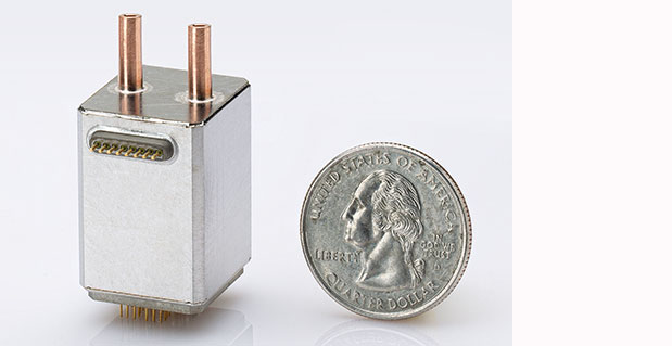
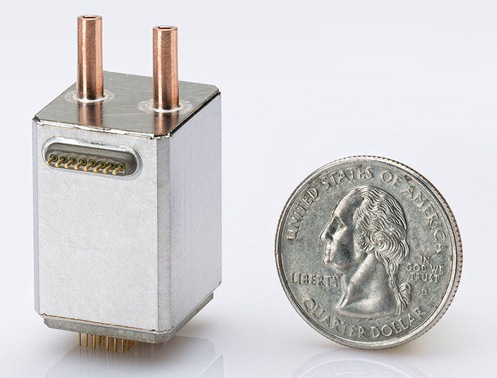
    The goal of the CSAC effort is to create ultra-miniaturized, low-power, atomic time and frequency reference units that will achieve, relative to present approaches: more than 200× reduction in size (from 230 cm3 to <1 cm3); more than 300× reduction in power consumption (from 10 W to less than 30 mW); and matching performance (1 × 10–11 accuracy and 1 ns/day stability). This work, funded by DARPA since 2002, has been supporting 11 teams. The program is currently in its final phase and supports two performers, Symmetricom and Teledyne Scientific. Symmetricom has already demonstrated pilot units that are 1 cm3 in volume, consume on the order of 100 mW of power, and perform on the level of better than 30 × 10–11 short-term 1 sec instability (Allan Deviation) and 5 × 10–11/day (1.4 × 10⁻¹⁰/month) long-term frequency drift.

    The IMPACT program seeks to improve the stability and accuracy of microscale atomic clocks by as much as two orders of magnitude. Atomic-clock performance is affected by buffer gases (nitrogen or argon), which are necessarily present in either rubidium- or cesium-based atomic clocks. Buffer gas atoms interact with alkali atoms and effectively shift the resonant frequency of atoms. Emerging atomic-clock technologies based on laser-cooled atoms and trapped ions could overcome the limitations of CSAC.

    The goal of IMPACT is to create miniaturized, low-power, integrated micro primary atomic clock technology that will achieve significant reduction in size relative to conventional clocks, but slightly larger than CSAC (volume less than 5 cm3 in final package, excluding battery); significant reduction in power relative to conventional clocks, but slightly greater than CSAC (50 mW); and two orders of magnitude increase in performance relative to CSAC (frequency accuracy 1 × 10–13, Allan deviation at one-hour integration time, and stability characterized by 5 ns/day time loss). The work, funded by DARPA since 2008, currently involves four teams: Honeywell, Symmetricom, Sandia National Laboratories, and OE Waves.

    The overall approach is based on sampling of atomic transitions at extremely low temperatures, requiring vacuum on the level of 10–9 Torr and the ability to trap atoms in a small volume. The technology has been previously demonstrated on a large scale, but transferring the technology to small scale is far from trivial, requiring major innovations. The effort has already demonstrated magneto-optical trapping in a 16 cm3 atomic cell, and chip-scale clocks implemented using cold atoms performing on the level, quality factor × signal/noise ratio ∼ 2.6 × 10¹⁰, time loss after 1 ms equal to 10–4 ns; after 1 second, 6 × 10⁻³ ns; after 1 hour, less than 10 ns; and after 24 hours, on the order of 100 ns. Frequency retrace was demonstrated at the end of the phase on the level of 10–11.

    Inertial Sensors and Systems. There are currently three efforts within the micro-PNT program involving the development of inertial sensors and systems: Navigation-Grade Integrated Micro Gyroscopes (NGIMG), Micro Inertial Navigation Technology (MINT), and Information Tethered Micro Automated Rotary Stages (IT-MARS).

    The NGIMG effort seeks to develop tiny, low-power, rotation-rate sensors capable of achieving performance commensurate with requirements for GPS-denied navigation of small platforms, including individual soldiers, unmanned (micro) air vehicles, unmanned underwater vehicles, and even tiny (for example, insect-sized) robots. By harnessing the advantages of microscale miniaturization, the NGIMG effort is expected to yield tiny (if not chip-scale) gyroscopes with navigation-grade performance characteristics: overall size less than 1 cm3 (no power source), power consumption less than 5 mW, ARW less than 0.001°/√hour, bias drift less than 0.01°/hour, scale factor stability on the order of 50 parts per million (ppm), full-scale range greater than 500°/sec, and bandwidth on the order of 300 Hz.

    The NGIMG effort has been funded by DARPA since 2005, and work is currently being conducted by three teams: Northrop Grumman, Boeing, and Archangel Systems. The work has demonstrated several experimental prototypes (some, but not all, independently verified by the government) performing on the level of ARW 0.01°/√hour,  and bias drift 0.05°/hour.

    The MINT effort seeks to develop microscale low-power navigation sensors that allow long-term (hours to days) precision navigation in GPS-denied environments. The goal is to create high-precision, navigation-aiding sensors that directly measure intermediate inertial variables, such as velocity and distance, to mitigate the error growth encountered by integrating signals from accelerometers and gyroscopes alone. In addition to aiding sensors such as velocity sensors, the combination of microscale inertial sensors will be integrated to a form-factor of one or two integrated circuits. Such an integrated sensor suite will be incorporated into the sole of a shoe for accurate and precise velocity sensing using zero-velocity events during walking.

    The final goal of MINT is to achieve an overall package and form-factor for a velocity sensor (excluding IMU) of less than 1 cm3, power consumption for the velocity sensor of less than 5 mW, 1-meter position accuracy after 36 hours of walking, and 10 µmeter/second velocity sensing bias per step. The effort has been funded by DARPA since 2008 and involves work by four teams: Carnegie Mellon University, Analog Devices, Northrop Grumman, and Case Western Reserve University/University of Utah. To date, the work has demonstrated positioning error on the order of 4 meters after 30 minutes of walking.

    The goal of the IT-MARS program is to implement and demonstrate a MEMS-fabricated rotary stage providing a rotational degree of freedom to planar MEMS structures and sensors, thus enabling free rotation of micro-structures and micro-sensors relative to the package, with coupled power and signal transfer from the rotating platform to the package. The IT-MARS effort may enable highly accurate calibration of inertial sensors and serve as a micro-platform for carouseling of inertial sensors that further enable on-chip calibration and gyro compassing. The ultimate program goal is to achieve an overall volume of no more than 1 cm3, power consumption for actuation on the order of 10 mW, angle position absolute accuracy to within 1 milli-degree, maximum wobble of 10 micro-radians, a rotation rate of 360°/second, and reliability (run time of rotor) greater than 104 hours.

    This effort, which has been funded by DARPA since 2009, supports three teams: UCLA, UC-Berkeley, and the Boyce Thompson Institute. The work has already demonstrated free rotated platforms, and future efforts will focus on manufacturability and precision control of the stage-rotation and reduction of wobbling.

    New Initiatives

    In January 2010, DARPA launched a coordinated effort focused on the development of microtechnology specifically addressing the challenges associated with miniaturization of high-precision clocks and inertial instruments. The new program, Microtechnology for Positioning, Navigation, and Timing (micro-PNT), aggregated the existing efforts (CSAC, IMPACT, NGIMG, MINT, and IT-MARS) and initiated four complementary new developments:

    • Microscale Rate Integrating Gyroscopes (MRIG),
    • Chip-Scale Timing and Inertial Measurement Unit (TIMU),
    • Primary and Secondary Calibration on Active  Layer (PASCAL),
    • Platform for Acquisition, Logging, and Analysis of Devices for Inertial Navigation & Timing (PALADIN&T).

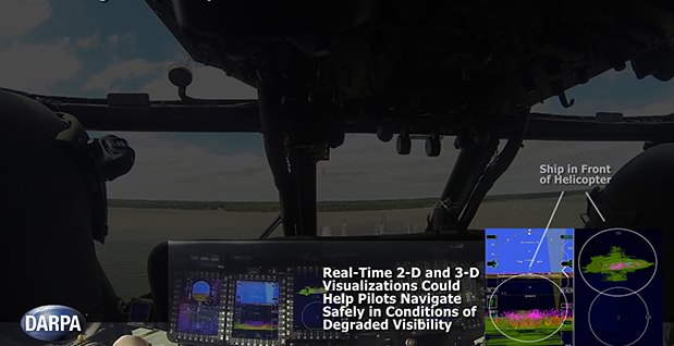
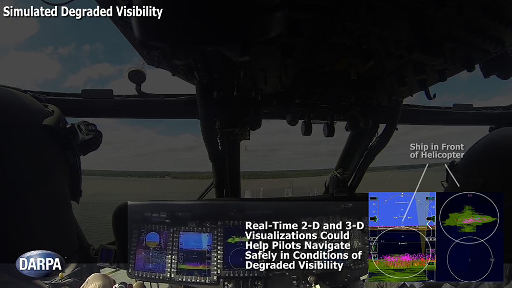
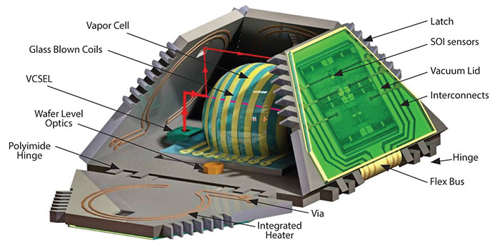
    The overall goal of the new aggregated micro-PNT program is to focus all of these complementary efforts toward achieving one specific overarching goal: self-contained chip-scale inertial navigation (see opening illustration). The reduction of SWaP+C of IMUs and timing units (TUs) is the technological objective. The developments consider a number of operational scenarios, ranging from dismounted-soldier navigation to navigation, guidance, and control (NGC) of UAVs/UUVs and guided missiles. The new micro-PNT initiatives will increase the dynamic range of inertial sensors, addressed by the new MRIG effort; reduce the long-term drift in clocks and inertial sensors, addressed by the PASCAL work; develop ultra-small chips providing position, orientation, and time information, addressed by the TIMU effort; and provide a universal and flexible platform for the testing and evaluation of components developed within the comprehensive micro-PNT program, addressed by the PALADIN&T effort.

    The primary goal of MRIG is to create a vibratory gyroscope that can be instrumented to measure the angle of rotation directly, thereby extending the dynamic range and eliminating the need for integrating the angular rate information; MRIG will thus eliminate the accumulation of errors due to numerical/electronic integration.

    The final goals are to:

    • extend the dynamic range to 15,000°/second;
    • achieve drift repeatability on the level of 0.1°/hour (angle dependent) and 0.01°/hour (bias-dependent) under variable –55°C to 85°C thermal conditions;
    • achieve ARW of 0.001°/√hour, an operation range of 1,000 g with acceleration sensitivity of 10–5 degrees/hour/g, vi
      bration sensitivity angle random walk of 0.01°/√hour per g/√Hz, and drift rate of 0.01°/hour per g2/√Hz.

    These performance characteristics are thought to be achievable through development of precision 3-D fabrication technologies utilizing high-Q materials; development of wafer-level balancing and trimming techniques that reduce the effects of aniso-inertia (mass misbalance), aniso- compliance (stiffness misbalance), and aniso-damping (damping misbalance); and development of active control and an active calibration architecture.

    These performers have been selected for the initial phase of the MRIG effort: Draper Labs, Honeywell, Northrop Grumman, Systron Donner, UC-Irvine, UC-Davis, UCLA, Cornell, University of Michigan, and Yale University.

    The TIMU effort will address challenges associated with the development of a miniature (10 mm3), low-power (200 mW), high-performance (CEP on the order of 1 nmi/hour), and self-sufficient navigation system on-a-chip. The smallest state-of-the-art IMUs perform on the level of tactical-grade instruments (CEP on the order of 100 nmi/hour) and are about the size of an apple (more than 104 mm3). This effort intends to develop a technological foundation for a navigation-grade TIMU (CEP less than 1 nmi/hour and time accuracy of 1 nanosecond/minute) with a significant reduction in SWaP, potentially miniaturizing the TIMU to the size of an apple seed (10 mm3).

    PASCAL will develop self-calibration technologies intended to eliminate long-term bias drift of inertial sensor and clocks. The grand challenge of this effort is to raise long-term bias stability to the level of 1 ppm.

    This level of stability represents a two-orders-of-magnitude improvement compared to state-of-the-art inertial microsensors, currently at 200 ppm. The work will investigate an approach for fabricating sensors on an active layer that may serve as a calibration layer for micro-PNT systems.

    The PALADIN&T effort will develop a universal platform for test and evaluation of early prototypes developed in the micro-PNT program. The effort will also simplify the uniform evaluation of pilot prototypes within the program and provide an early field demonstration, advancing the technology readiness level.

    Conclusions

    Current state-of-the-art microscale clocks and inertial instruments can provide the required level of precision only for missions having a duration of no more than about one minute. The micro-PNT program at DARPA is developing small SWaP+C inertial sensors for a variety of operational scenarios for missions ranging from minutes to hours. Current projects (CSAC, IMPACT, NGIMG, MINT, IT-MARS) mainly focus on navigation, characterized as missions of prolonged durations in relatively benign environments (a few hours of operation on a platform moving at relatively low speed, less than 100 km/hour).

    The new initiatives (MRIG, TIMU, PASCAL, and PALADIN&T) target the challenges of missile guidance for precision engagement scenarios, short duration missions in highly dynamic environments (10 seconds to 3 minutes of operation at speeds of 1,000 km/hour and higher). Ongoing efforts and new initiatives explore new physical phenomena, high-quality factor materials, specialized fabrication technologies, and innovative approaches to system integration.

    Disclaimer. The views, opinions, and findings in this article are those of the author and should not be interpreted as representing official views or policies, either expressed or implied, of the Defense Advanced Research Projects Agency or the Department of Defense. The document GPS0911 [DISTAR case 17952] is approved for public release, distribution unlimited.


    Andrei M. Shkel received a Ph.D. in mechanical engineering from the University of Wisconsin-Madison and is a program manager in the Microsystems Technology Office at the Defense Advanced Research Project Agency (DARPA), and on-leave professor of mechanical and aerospace engineering at University of California, Irvine, where he is also the director of the UCI Microsystems Laboratory. He holds 15 U.S. and international patents (12 pending) on micromachined angle-measuring gyroscopes, wide-bandwidth rate gyroscopes, light manipulators and tunable optical filters, and hybrid micromachining processes.

  • The System — September 2007

    AEP on the Ground

    Advance to a New Architecture

    The U.S. Air Force Space and Missile Systems Center (SMC) announced in late August that the long-planned upgrade of the GPS command and control system will occur during the second week of September, fulfilling a major program commitment for 2007.

    Dubbed the Architecture Evolution Plan (AEP), the upgrade will replace the entire GPS master control station, including both software and hardware, some of which dates back to GPS’s inception in the 1970s. The upgrade will, among other things, begin preparing the master control station to work with the latest generation of Block IIF satellites when they go into orbit; further work with the next-generation OCX, however, will be necessary for managing M-code and the new L5.

    “The delivery of SMC’s new GPS ground segment to the 50th Space Wing [will enable] transition of satellite operations from a 1970s-era GPS mainframe computer to a new server-based AEP ground segment,” said Lt. Gen. Michael Hamel, SMC Commander. “I am very proud of the team that has thoroughly tested the new system to ensure no change to the GPS signal during the changeover to the new system. The best analogy I could make is that this is like changing the engine on a car while traveling 50 miles an hour down the road.”

    Col. David Madden, GPS Wing Commander, added “The replacement of the legacy system to AEP is a benefit to both the warfighter and the civil community. AEP is designed to improve operations, increase efficiency, and provide a foundation for new capabilities as they become available. The replacement from the legacy mainframe system to a distributed architecture provides the capability to command and control the next generation of GPS satellites and lays the foundation for a new security architecture to support the warfighter in the field.”

    The AEP transition will take place over a period of four to six days; the total cost of the new ground control system amounts to approximately $800 million. The Air Force will not announce the exact date and time of transition, but will inform users 48 hours after completion.

    The upgrade features a new satellite control foundation that replaces the legacy system and adds new digital communications. This means installing and activating a new master control station at Schriever Air Force Base which includes new hardware and software to generate navigation messages, a new system for controlling satellites, and new capability to command satellites through the Air Force Satellite Control Network (AFSCN). Adding the AFSCN will increase the number of available antennas for contacting satellites. The upgrade also involves installing and activating the alternate Master Control Station at Vandenberg AFB in California, and upgrading the current GPS ground antennas.

    Ground control at Schriever AFB will phase in a few satellites in the GPS constellation at a time; the process will be completely reversible if it encounters any problems. Before it begins, both old and new ground control systems will be synchronized in terms of positioning data, namely their reception of satellites’ timing and navigation signals, down to the millimeter level. GPS users should not notice the transition, according to the Air Force.

    The AEP will retain all of the legacy monitoring stations around the world currently utilized by the U.S. Air Force, as well as the National Geospatial-Intelligence Agency (NGA) monitoring stations around the globe originally added as part of the Legacy Accuracy Improvement Initiative. Additional NGA monitoring station sites are in the process of being brought online for future inclusion within the AEP.

    Galileo Tests; Rescue Role

    System-Observatory
    The antenna dish at Chilbolton Observatory.

    The test campaign using the large antenna at Chilbolton Observatory to analyze the navigation signals transmitted by GIOVE-A, the first Galileo satellite, has been successfully completed, the European Space Agency (ESA) announced in mid-August.

    Analysis of the satellite’s signals since January 2006, to verify their conformance with the Galileo system specification, has involved the Navigation Laboratory at ESA’s European Space Research and Technology Centre (ESTEC) in the Netherlands, the ESA ground station at Redu, Belgium, and the Rutherford Appleton Laboratory (RAL) Chilbolton Observatory in the United Kingdom.

    Following signal analysis, operators have made some adjustments, re-programming the spacecraft’s navigation signal generation unit to compensate for changes to the signals introduced by the amplifier that boosts them for transmission to Earth and by a filter that protects adjacent frequency bands from interference.

    To achieve the correct solution, the calibrated Chilbolton station was used to receive the signals from GIOVE-A. ESA’s Navigation Laboratory processed the resulting data. The signal generator manufacturer, TAS (France), calculated the new settings for the unit. Finally, the satellite manufacturer, Surrey Space Technology Limited (SSTL), uploaded the new values to the payload using their ground station at Guildford, in the United Kingdom.

    According to ESA, “GIOVE-A is now transmitting optimized signals. Research and testing continues, and manufacturers are using the signals as they develop the receivers that users will need when Galileo enters operational service.”

    Global Search and Rescue. Once operational sometime after 2012, Galileo will improve the detection of emergency beacons, according to program representatives whoattended the annual Joint Committee Meeting of COSPAS-SARSAT, the international program for satellite-aided search and rescue. Galileo satellites will carry transponders to relay distress signals to search and rescue organizations. Galileo partners have committed to developing a search and rescue component as an integral part of Medium Earth Orbit Search And Rescue (MEOSAR), the future worldwide search and rescue satellite system.

    COSPAS-SARSAT already has systems operating in low-Earth orbit and geostationary orbit. The low-Earth orbit satellites can determine the location of emergency beacons using the Doppler effect as they pass overhead. However, there is a delay in relaying the distress signal because the satellites can only “see” a part of the Earth’s surface at any given time and a beacon is only detected when the satellite passes nearly overhead. Also, the satellites must store the location of the emergency and transmit it to a ground station once one comes into range, creating further delay.

    Search and rescue transponders on geostationary satellites can constantly view a large, fixed area of the Earth, eliminating the time delay in detecting distress signals. However, they cannot automatically determine the location of the distress beacon as the low-Earth orbit system does, but must rely on the beacon to use a navigation system to find its position and include it in the distress call.

    Emergency beacons require a direct line-of-sight to the geostationary satellites. There are some situations where this is impossible, such as near the Earth’s poles, where the satellites are too low in the sky, or when an accident occurs where surrounding terrain obscures the satellite.

    Future Improvements. To improve performance of the overall COSPAS-SARSAT system, plans are now being made to fly search and rescue payloads on future navigation satellites. The various navigation satellite constellations will each have about 20 to 30 satellites in medium-Earth orbit, providing global coverage, including at the Earth’s poles, and with multiple viewing angles to the satellites, eliminating terrain blocking.

    The Galileo search and rescue component will provide two services. The Forward Link Alert Service, backward-compatible with current COSPAS-SARSAT components and interoperable with all other planned MEOSAR elements, detects activated distress beacons and notifies the appropriate rescue body. A new Return Link Service will send a return message to the emergency beacon, notifying the emergency victims that their distress signal has been received and help is on its way.

    The Galileo In-Orbit Validation Programme, which will have four satellites fitted with search and rescue transponders, will demonstrate the Galileo MEOSAR services — although its flight timetable has yet to be finalized or announced.

    DOT Weighs NDGPS Future, Asks Public Input

    The U.S. Department of Transportation’s (DOT) Research and Innovative Technology Administration (RITA) is preparing an assessment on the inland component of the Nationwide Differential Global Positioning System (NDGPS) that will determine its future.

    As part of that assessment, it is seeking public input from users of the system.

    The current expansion of the NDGPS has been placed on hold pending congressional review of the system’s funding; RITA’s assessment is part of that review. Differential GPS uses the fixed location of a reference station on the ground to improve the positioning resolution provided by civilian GPS satellite signals down to 1–3 meters. NDGPS facilities also monitor GPS satellites for anomalous behavior and issue integrity warnings when necessary.

    The NDGPS program is operated jointly with the DOT’s Federal Highway Administration, Federal Railroad Administration, and Office of the Secretary of Transportation; the Department of Homeland Security’s U.S. Coast Guard; the Departmentof Commerce’s National Geodetic Survey and Forecast Systems Laboratory; and the Department of Defense’s Air Force and Army Corps of Engineers. Begun in 1997, to date there are 37 operational NDGPS sites. Two additional sites are ready for construction and could be operational in a matter of months, according to the Coast Guard.

    As part of the assessment, RITA published a notice in the Federal Register addressing the current user requirements for the inland or terrestrial component of the NDGPS. This assessment is in preparation for making a recommendation to the National Space-Based Positioning, Navigation and Timing (PNT) Executive Committee, which oversees the entire GPS, on the need to continue to operate inland NDGPS and to make a decision on its future funding.

    If no transportation requirements or other federal user requirements are identified as a result of the needs assessment, and if there are no other federal or other funding sources willing to sponsor or partner in sponsoring NDGPS, the DOT will develop a decommissioning plan for NDGPS, according to RITA.

    The deadline for public comment is October 1, 2007. Comments may be submitted via the Internet at the Department of Transportation Web site. Instructions for other methods of submitting comments, including via postal service and fax, can also be found there in the docket management portion of the site.

    The Robots of DARPA

    The U.S. Defense Advanced Research Projects Agency (DARPA) has named 36 teams as semifinalists for its Urban Challenge to take place later this year.

    The DARPA Urban Challenge will feature autonomous ground vehicles executing simulated military supply missions in a mock urban area. It will take place November 3at an urban military training facility located on the former George Air Force Base in Victorville, California.

    The 36 semifinalists will compete in the Urban Challenge National Qualification Event (NQE), October 26–31. The top 20 teams from the NQE will move on to the Urban Challenge final event on November 3, and compete for cash prizes worth $2 million for first, $1 million for second, and $500,000 for third place.

    At the NQE and the final event, the robots must operate entirely autonomously, without human intervention, and obey California traffic laws while performing maneuvers such as merging into moving traffic, navigating traffic circles, and avoiding moving obstacles. DARPA conducted competitive site visits across the United States to select the semi-finalists.

    “The depth and quality of this year’s field of competitors is a testimony to how far the technology has advanced since the first Grand Challenge in 2004,” said DARPAdirector Tony Tether.

    Stanford University’s winning robot vehicle from the last DARPA Challenge in 2005, which ran across the Mojave Desert, consisted of a stock Volkswagen Touareg R5 thatincorporatesd measurements from GPS, a 6DOF inertial measurement unit, and wheel speed for pose estimation.

    Click here for the list of semi-finalists, along with other race information.


  • DARPA Seeks GPS Complement

    A Boeing-led team is working on a so-called Robust Surface Navigation (RSN) concept for the U.S. Defense Advanced Research Projects Agency (DARPA). The objective of the RSN program is to develop navigation technology that can be exploited in the event GPS signals are jammed, blocked or otherwise unavailable.

    In theory an RSN system would utilize various “signals of opportunity” — signals emanating from satellites, but also those emanating from cell phone towers and television transmission towers, for example — to provide precise location and navigation information to users on the ground.

    “The challenge is to develop an integrated system that can use all available signals — not just GPS — to provide accurate navigation information through one small receiver, thereby eliminating the need for an expensive, fixed infrastructure,” Bart Ferrell, Boeing Phantom Works program manager for Precision Navigation Programs, said in a statement.

    The Boeing-led RSN team is beginning its 15-month Phase 1 concept development contract. The team includes Rosum of Mountain View, Calif.; Shared Spectrum, of Vienna, Va.; and veteran GPS navigation company Navsys.

    Rosum has used broadcast television signals to locate mobile assets and has combined television and GPS signals in location-based applications. Shared Spectrum supplies cognitive radio technologies for government and commercial customers with challenging radio communications and networking needs. Its expertise includes defense communications in extremely challenging RF conditions and commercial communications involving novel approaches to sharing and managing spectrum access.

  • Driving for Dollars: Urban Challenge Purse Put at $3.5 Million

    The Defense Advanced Research Projects Agency (DARPA) will award $2 million, $1 million, and $500,000 awards to the top three robotic finishers who complete its new Urban Challenge course in November 2007.

    Under Secretary of Defense for Acquisition, Technology and Logistics Kenneth J. Krieg approved the cash prizes, evidencing the Department’s interest in making one-third of all combat vehicles — principally supply vehicles — driver-less by 2015.

    DARPA has staged two desert Grand Challenges, in 2004 and 2005 in the Mojave, with significant difficulties posed by geography and terrain. The 2007 Urban Challenge will feature fully autonomous ground vehicles conducting simulated military supply missions in a mock urban area. The race will take place on November 3, 2007, at a location to be announced later, in the western United States.

    Robotic vehicles will attempt to complete a 60-mile course through traffic in less than six hours, operating under their own computer-based control. Vehicles must obey traffic laws while merging into moving traffic, navigating traffic circles, negotiating busy intersections, and avoiding obstacles.

    Learning Curve. Participants in past Grand Challenges have truly risen to the occasion, learning and innovating as they go. The number of sensors and software applications integrated into most of the experimental vehicles increased dramatically between the first and second races. Inertial sensors proliferated, with cost, size, and power consumption going down, while performance went up. Inertial systems, along with various camera/vision apparati, function as the workhorses covering the ground in most of the vehicles. GPS generally teams with a central processing unit (CPU) to act as the brain guiding the process.

    William “Red” Whittaker of Carnegie Mellon University’s Robotics Institute and Louis Nastro of Applanix Corporation co-authored a detailed technical article in September 2006 GPS World on their experience with the students of Carnegie Mellon’s Red Team Racing effort, designing and outfitting two vehicles that competed and placed in the 2005 race.

    To qualify for the race or simply watch, see the Grand Challenge website for additional information and rules for the Urban Challenge.