DigitalGlobe has received a third customer commitment for direct access capacity on the WorldView-4 satellite, bringing the total in commitments for both WorldView-3 and WorldView-4 to $335 million. The WorldView-4 satellite will provide 30-cm imagery, the highest resolution commercially available, to international defense and intelligence customers.
WorldView-4 is scheduled to launch in September and begin commercial operations of gathering digital imagery in early 2017. DigitalGlobe is a global provider of commercial high-resolution Earth observation and advanced geospatial solutions.
Artist’s depiction of the WorldView-4 satellite (previously named GeoEye-2). Photo: Digital Globe
Since the end of the third quarter of 2015, DigitalGlobe has received contracts and letters of intent from international defense and intelligence customers totaling $335 million for capacity on WorldView-3 and WorldView-4, representing $38 million of incremental annual revenue starting in 2017.
DigitalGlobe accelerated the launch of WorldView-4 to meet strong international demand for the world’s highest resolution commercial satellite imagery, and these pre-launch commitments ensure that the satellite will begin generating revenue in early 2017.
Approximately 60 percent of this potential future revenue is under firm contract. While there is no assurance that revenue reflected in the letters of intent will turn into contracts, this has historically been the case.
WorldView-4 revenue is expected to start to be recognized in the first quarter of 2017.
“The fact that we have this level of commitment from multiple international customers — more than half in the form of firm contracted revenue — this far in advance of the WorldView-4 launch is unprecedented,” said Jeffrey R. Tarr, DigitalGlobe president and chief executive officer. “It is a testament to the unique value of our resolution and accuracy and our long history of performance with these customers who rely on us for the safety and security of their nations.”
With the most advanced constellation of satellites in orbit, DigitalGlobe is investing in the best technology to meet the growing needs of its customers. The company has been upgrading the ground stations of its Direct Access Program customers to a common architecture to fulfill the demand for rapid access to the entire DigitalGlobe constellation and offer more imaging opportunities to these customers. Four of these Constellation Direct Access Facilities are now online, with a fifth ground station expected to be upgraded in the second quarter and all facilities upgraded for full constellation access by early 2017.
“We are in discussion with many other nations interested in our high resolution, high accuracy 30 cm satellite imagery, and the launch of WorldView-4 will allow us to satisfy unmet customer demand across much of the world,” said Daniel L. Jablonsky, DigitalGlobe general counsel and general manager for International Defense & Intelligence. “The investments we are making to enhance our customers’ direct access facilities will expedite access to WorldView-4 in 2017 and allow us to provision additional access facilities with greater speed and efficiency.”
Last summer at the Space and Missile Defense Symposium, GEO Huntsville held its annual GEOINT workshop including a keynote by NGA (National Geospatial-intelligence Agency) Deputy Director Sue Gordon. One of the sessions, presented by Mike Botts, focused on the OpenSensorHub and related information published on GitHub.
His topic: clearing the path for use of geospatial-capable devices via the Internet, thus preventing a geospatial Tower of Babel.
In the mid-80s, I purchased my first personal computer from Sharper Image, a 286 with a monochrome monitor. The PC was not bad for its time, and I learned a lot about personal computing, but hooking up a dot-matrix printer at the time was a nightmare. There were numerous types of printer cables — 25-pin parallel, 36-pin Centronics, 15-pin, etc. Additionally, some printers needed changes to the pin configurations, so nothing about the process was easy.
Then, after the mechanical connections were made, proper drivers had to be loaded, not to mention operating system and software configuration. Today, you simply plug in a USB cable or go wireless and are off and running thanks to “plug and play.” However, plug and play is only common in popular mass-market devices such as printers, scanners and cameras. Most other devices, even commercial consumer devices, can still present maddening connection challenges.
One example: About five months ago, I tested more than a dozen different Internet video security cameras for a special project. All the cameras I tested touted quick and easy connection. Some were quite nice, while others were installation torture — I returned those after a few days.
One well-known consumer brand was especially bad. I spent more than three hours with hard-to-understand tech support in India, and after countless different IP configurations and tests, I gave up. I decided that my remaining life is too short to waste that much time on a poorly designed camera system.
(By the way, the FLIR FX and Netgear Arlo were my top choices. Both connected fast and easy, both have especially nice cloud applications and both are wireless, including power. The FLIR is rechargeable, but the battery life of the Arlo seems remarkable, although some reviewers differ, especially outdoors and in freezing weather. In my test, after three months of flawless operation indoors, the Arlo is still on the original set of batteries at 60 percent, so it gets my top nod.)
OpenSensorHub
What is OpenSensorHub, and what are they doing to help achieve universal plug and play? By their own definition:
“OpenSensorHub is a license free, open source software platform for geospatial (FOSS4G) sensors that allows you to easily, rapidly and affordably network sensors into a seamless SensorWeb of real-time, location-aware, interoperable, web accessible services. With OpenSensorHub, these OGC compliant SensorWebs can be enabled across all manner of space-based, airborne, mobile, in situ and terrestrial remote sensors — including your basic mobile device. OpenSensorHub finally makes it possible to integrate location-aware sensors into the geospatial mainstream.”
(FOSS4G — Free and Open Source Software for Geospatial — is an annual recurring global event hosted by OSGeo growing out of the GRASS and MapServer communities. OSGeo — Open Source Geospatial Foundation — promotes open source software and resources. OGC — Open Geospatial Consortium — promotes open geospatial standards for both open source and proprietary software.)
The OpenSensorHub evolved from the early work of Mike Botts of Botts Innovative Research and Alex Robin of Sensia Software for NASA. They very laboriously designed and developed systems and software to connect sensors and actuators into an interoperable and integrated environment. They also realized that this connectivity and integration process had to become streamlined and not a custom programming effort every time for every device. Thus was born the idea of Sensor Model Language (SensorML) and, thanks to NASA funding in 1999, it became a reality.
Over the years, many scientists and engineers worked to develop connectivity for devices that could be queried and controlled through the Internet, called the Internet of Things (IoT). However, a key missing element of IoT was location awareness, so in 2000, SensorML was brought to the Open Geospatial Consortium (OGC) and served as a catalyst for the creation of a suite of open standards to support location-enabled discovery, access and tasking of sensors through web services and XML encodings. They named it the OGC Sensor Web Enablement (SWE) standards, or SWE for short.
The SWE standards, now in version 2.0, have been adopted worldwide supporting scientists, emergency responders and the military. Although SWE opened the door to geospatial integration, much work still remains to achieve true plug-and-play connectivity of thousands of devices. In my mind, SWE is standardizing communication protocols between sensor and actuator devices, much like USB standardized interactions between disparate devices.
However, what really enables us to plug in a USB cable and have instant and effortless communication between various devices, is the software and hardware that implement the USB standard protocols. This, in essence, is the focus of the OpenSensorHub community, to provide open software and hardware that fully implement the SWE vision and enable us to have effortless interaction between IoT devices.
This is also where the OpenSensorHub community needs your help. In addition to helping improve the significant capabilities of the OpenSensorHub Core, the OpenSensorHub community is looking for those interested in deploying sensors and in developing adaptors and adaptor technologies for adding new sensors, actuators, and processes.
If you’d like to learn more about the technology and ways that you can contribute, check out the OpenSensorHub website or contact the team at [email protected].
Russian Space Systems (RCC) has completed work on the GLONASS navigation system, passing its final tests for the customer, the Russian Ministry of Defense, reports the TASS news agency.
The system has not yet been formally adopted by the Ministry of Defense, and remains in the research and development phase, RCC CEO Andrew PKC Tyulin the told the Izvestia newspaper.
“We presented the system to the customer for final tests, which are coming now,” Tyulin said. “During the tests, the customer gave us some comments, which we addressed, and Nov. 5 tests were resumed.”
He said every effort is being made to complete the work. “We hope that the results of the test system will be put into operation. ”
The Bullray UAS is a fully autonomous, amphibious, man-portable tricopter/quadcopter that makes vertical take-offs and landings.
Rated IP-67, the rugged design is capable of performing in all weather conditions and doesn’t require a transit case. It can carry a significant sensor payload: GPS, FLIR cameras, lidar, metal detection systems and more.
Rapid Composites — builder of high-end UAVs for the military and first responders — custom manufactures the units. The company won the UAV category in the 2015 JEC Innovation Awards.
That is, in the People’s Republic of Boulder, Colorado. To those of us who live in Colorado, Boulder is known by this seemingly timeless but absolutely accurate appellation. This stunningly beautiful city located in the foothills of the Rocky Mountains, known as the Flatirons, is where the National Space-Based Positioning, Navigation and Timing Advisory Board (PNTAB), which provides independent advice to the National Executive Committee on Space-Based PNT (EXCOM) from outside the U.S. government, chose to meet in the waning days of October 2015. Ironically, they chose the same week as a Republican presidential candidates debate, which took place at the University of Colorado just a couple of miles away. The PNTAB was also concomitant with the ICG, the Tenth Meeting of the International Committee on GNSS (ICG-10), held Nov. 2-5, 2015. Both the PNTAB and ICG were held at the Boulder NCAR/UCAR facility, University Corporation for Atmospheric Research Center Green Conference facility.
PNTAB
The PNTAB serves a vital purpose. Board memberse advise the highest levels of the U.S. government (USG) concerning all matters relating to PNT. This open-ended charter covers a multitude of sins, and as the new PNTAB Chairman John Stenbit, stated clearly, it is important to focus on the doable, even if it seems difficult, but not to tilt at windmills. I have known and worked with John Stenbit for more than 25 years, especially during his two stints in the Pentagon, and I find him to be extremely knowledgeable and ethical. He is certainly well-spoken and gregarious, but he does not suffer fools, and is known to be resolute, which is a pseudonym for stubborn and hardheaded, but in a good way. I look forward to his chairmanship.
PNTAB Members at 16th Meeting in Boulder. New Chairman John Stenbit is center of last row. (Courtesy of gps.gov)
You can view the PNTAB presentations at the www.gps.gov website. While there, you will note there were more than 25 presentations, and most were excellent. Only a couple required the audience to consume copious amounts of caffeine to remain coherent.
In the end, the PNTAB adopted courses of action (COA) on which to formulate recommendations for the EXCOM. For our purposes, the pertinent COAs centered around two main subject areas: Spectrum protection and eLoran. The spectrum protection issues are fraught with equal parts litigious danger and tedium. Not coincidently, the World Radiocommunication Conference 2015 (WRC-15) kicked off in Geneva, Switzerland, on Nov. 2, just two days after the end of the PNTAB. Several of the PNTAB members attended the closing Saturday night PNTAB dinner and flew from Denver direct to Geneva Sunday morning, just in time for some minor jet lag adjustments, and then attended the opening ceremonies of WRC 2015 in snowy Switzerland.
I have had the dubious privilege of observing several International Telecommunication Union (ITU)-sponsored WRC sessions in the past, and it is certainly a critical spectrum decision-making body. (Seriously, folks, 26 days of talking and wrangling about spectrum? Praise the Lord the Swiss know how to brew strong coffee.) WRC 2015 wraps up on Nov. 27. In this regard, Ann Ciganer, who serves as an official PNTAB representative and the executive director of policy for the GPS Innovation Alliance (GPSIA, formerly the U.S. GPS Industry Council), is my hero. She has been working spectrum issues for more than 20 years. She has the fortitude of FDR and the patience of Job.
Since the spectrum and spectrum-protection issues are still being coldly debated in Geneva, let’s take a look at the PNTAB’s second major topic, eLoran. While eLoran was discussed ad nauseam, there was one definitive standout presentation given by my old friend and colleague Professor David Last. David is Professor Emeritus at the University of Wales (Bangor) and former president of the Royal Institute of Navigation (RIN). As he is wont to do, David held forth, with that wonderful, attention-arresting British public school accent, on eLoran matters before an appreciative audience. David presented his topic with equal parts passion and credibility. You can view his presentation material in its entirety (the PowerPoint slides, anyway) at www.gps.gov, but you will not have the wonderful experience of having him present it personally with all the attendant persuasion, and dry British humor and wit.
eLoran European Style
David immediately makes the point early on in the historical portion of his presentation that the U.S. first committed to Loran-C more than 75 years ago, and as recently as 2010 upgraded a majority of the sites to eLoran status only to have the current administration shut down Loran just after officially assuring the United Kingdom the U.S. would keep Loran up and running. Now the U.S. is in the position of looking for a backup and major terrestrial augmentation to GPS (GNSS) and is once again considering eLoran.
Professor David Last at 16th PNTAB
Professor David Last at the 16th PNTAB meeting. (Photo: Don Jewell)
Professor Last explained the difference between our viewpoints. “I see it from a British perspective, and a European perspective. I watch administrations in other parts of the world grappling with the same decisions the U.S. faces. The U.S., of course, is in a unique position: it is the source of GPS, the world standard in satellite navigation. And over the nearly 40 years since the first satellite was launched, the U.S. has taken the lead in learning to understand the role of GPS, from its military-only origins, through when it was a novelty with its first civil applications, through a period of hubris in which it was to replace every other means of navigation on land, sea and air, to its present role, so deeply embedded in your national life as to form a critical component of national infrastructure. The U.S. was first to recognize the vulnerabilities of GPS, to understand the threat they posed to your nation and to seek ways of mitigating them. That topic came to dominate technical conferences first in the U.S. and now around the world. And it has led to a policy debate of quite exceptional difficulty, one that is shared by all governments.”
The Message
What David did not come right out and say, although I maintain it was implied by his tone of voice and body language, is that this discussion is at times both energized and denigrated by those that refuse to acknowledge GPS or GNSS vulnerabilities and those that would be happy to see it revert to a military-only system — the proverbial ostrich syndrome. David made it clear that GPS vulnerability discussions must take place publicly in the U.S. because they are, in fact, global discussions. “All space-based PNT systems today are similar to GPS in concept and technology, and referred to by most users as GPS,” he said. “Very few bother or even know about Galileo, GLONASS and BeiDou. To them, it is all simply GPS.”
David went on to make his point by describing the ubiquity and pervasiveness of GPS and GNSS. “Now there is no area of transportation, commerce, industry or telecommunications in your country or mine that does not employ satellite navigation.”
Indeed, David described how other GNSS systems came about due to national pride, and yet they had no choice but to mimic GPS both technically and officially, since they must for safety-of-life concerns reside in the same regimes and crowded radio bands.
David stated, “Soon, these new GNSS became invested with immense national pride. Their vast cost had to be justified by claims of technical superiority. In reality, engineers know that their designers had no choice but to make them compatible with GPS, since GPS was decades ahead and the world standard. These new systems also had to squeeze alongside GPS in the narrow radio bands allocated internationally to navigation. Not surprisingly, indeed happily, all our new GNSS turned out to look very like GPS: versions of the same technology — with just a hint of garlic here, a whiff of curry there. This similarity is obvious to engineers and to navigators, though rarely to politicians.”
DOT Volpe GPS Jamming Report
Professor Last referred to the U.S. provider and user communities as groups that, prior to the important 2001 Volpe Report, failed to acknowledge that GPS had any serious vulnerabilities. That report was a watershed event for the future of GPS, and for me as a journalist. Among other jamming incidents around the country, a major jamming occurrence in San Diego harbor affected GPS-dependent systems (mostly those dependent on accurate timing) and users for miles around. It became a wakeup call for GPS and GNSS users globally; I wrote a Defense PNT column on it in this space in 2007.
David put it in perspective. “To understand the perceptions of those governments, wind back the U.S. story to before the Volpe Report on GPS vulnerability with its recommendations that led to your [PNT Advisory] Board’s policy of ‘Protect, Toughen, and Augment’. Despite the growth of jamming and even attacks by one sovereign nation on its neighbor, despite the appearance of low-cost spoofing, there has never been a Volpe Report anywhere outside the United States. The pre-Volpe culture of the denial of vulnerability is alive and well and living in Europe.”
“Thirty-seven years after the launch of the first GPS satellite, there is still little recognition by the world’s governments of how essential resilient position, navigation and timing have become to the critical infrastructure of their nations,” Last said.
After the Volpe Report came an industry report chaired by the Father of GPS, Professor Bradford Parkinson (Col, USAF, Ret), describing eLoran as the only cost-effective method of backup to GPS. The report was published globally, and then the United States completely failed to implement the transition from Loran-C to eLoran. At the time it failed politically, the Loran-C to eLoran conversion was 85 percent complete and only needed a small amount of funding for the future. Luddites within the U.S. OMB (Office of Management and Budget) managed to kill the program just short of completion. Unfortunately, the message to the world of GPS users was the U.S. had categorically rejected eLoran as a complimentary PNT system.
David presented the European point of view: “The Volpe Report, an FAA study, proposed and demonstrated Enhanced Loran (eLoran). GPS-like digital techniques were applied to the obsolete Loran-C low-frequency system. The result were astounding: it met the accuracy, integrity, availability and continuity standards of certain aircraft instrument approaches plus the very demanding port-entrance requirements of shipping, and it delivered precise timing to support telecomms. Brad Parkinson’s high-level study group of industry leaders said this was the only cost-effective GPS substitute for U.S. needs.
“The world outside the U.S. watched the Department of Homeland Security announce eLoran as the U.S. national backup to GPS and then completely fail to implement it! That message, that the U.S. does not need a complementary system and has rejected eLoran, is the current understanding of U.S. policy in many countries.”
Professor Last maintains the same eLoran drama is now being played out in Europe in real time. The UK developed its own eLoran system from the North of Norway to the South of France which, while it only officially achieved initial operational capability on Oct 31, 2014, has in fact been running flawlessly 24/7 for three years.
The message to the world, especially Europe, should be that the eLoran concept proposed by the U.S. FAA (Federal Aviation Administration) really works and is easy to implement. It has been, in fact, implemented and maintained in the UK by a mere handful of personnel.
However, according to David, the European eLoran system may never reach FOC (full operational capability) because currently Western Europe lacks any coordinated plan to respond to the vulnerabilities of GPS and all other PNT systems. Many have yet to embrace or even recognize the Volpe Report.
Indeed, several European countries are planning to shut down their eLoran systems supposedly since that is what we (the U.S.) did and it seems to be working for us.
David explains that “this [proven] system may never reach Full Operational Capability. Western Europe lacks any coordinated plan to respond to the vulnerability of GPS — why, who needs that when Europe has Galileo and EGNOS! The governments who control the Loran stations in Norway and France, observing that mariners no longer want Loran-C, plan to close down the transmissions just nine weeks from now, and demolish the infrastructure. After all, they say, that is what the U.S. did.”
Service Alternative
To paraphrase Winston Churchill, this was indeed not our finest hour. However David maintains there is a realistic commercial alternative: provide eLoran as a service. This is exactly what some in the United Kingdom and Europe are considering. It is a totally viable alternative, but David asserts that what would really help “is a positive signal from the United States.”
Continuing in the same vein, David posits “all is not lost. Responding to the future — indeed, the present — needs of the telecomms and broadcasting industries, and driven from the U.S., there is a commercial plan to take over and operate that European Loran infrastructure and sell its services to government and industrial users. If governments struggle to seize the initiative in this area, let the market — and good old greed — provide the mechanism for realizing the multiple benefits, paying the costs and making a profit. But I believe that this initiative will only succeed in Europe, if there is a positive signal from the U.S. The world listens to signals from the U.S., from the EXCOM, from this board.”
Unique Organizations
Historically, relationships between multi-GNSS systems are confrontational at best; however, David states clearly that Europeans realize the PNTAB and EXCOM are unique and unprecedented around the world. “These official government entities recognize and advocate for resilient PNT that is of major importance to critical infrastructures of the U.S. and other nations as well.”
In actuality, the U.S. has faced up to these vulnerabilities thanks to the PNTAB and EXCOM, two truly unique organizations. Undeniably, there is an incalculable polyphonic argument to be made concerning the vulnerabilities of space-based PNT systems such as GPS and how to mitigate them, but globally beyond the PNTAB and EXCOM, no one is officially having these critical discussions.
In the end, according to Professor Last, over the next nine weeks the immediate future of PNT really comes down to one critical question: “Will global PNT with eLoran be a global system or a nationally unique system?”
David supports his cogent argument for eLoran by giving excellent examples of GPS and multi-GNSS jamming supporting his insightful adage, “Space-based PNT systems live and die together.” They are all subject to the same vulnerabilities.
Wrapping up his refreshingly insightful presentation, Professor Last posed two questions to the PNTAB:
Does the U.S. see a role for eLoran as a complement to resilient GPS?
Does the U.S. recognize and encourage the move to GNSS receivers that take advantage of multiple constellations?
As one PNTAB pundit opined, “The critical issue for the U.S. government is we have to break the mold. The current administration is too often technologically controlled by Luddites and held hostage by low-level bureaucrats within OMB.”
Professor Last appropriately has the last word: “The bottom line for the PNTAB, EXCOM and USG is that the United Kingdom, nee Europe, is asking for support on eLoran.”
Until next time, happy navigating and don’t forget your GPS when you head over the bridge and through the woods to Grandma’s house. Happy Thanksgiving!
At Unmanned Systems Defense, warfighters had the opportunity to learn about new technologies from government contractors and see demos in the exhibition hall. (PRNewsFoto/AUVSI)
ARLINGTON, Va. — Despite shrinking defense budgets, existing and emerging worldwide threats will make robotic and autonomous systems’ development important for decades, said officials at the Unmanned Systems Defense 2015 conference held here Oct. 27-29.
Because America has been at war for more than 14 years, unmanned technology has been developing at a rapid rate, perhaps even faster than emerging autonomous commercial systems. The replacement of even manned aircraft has some in the military establishment wary, but others know it’s only a matter of time before most vehicles, surface ships and aircraft are unmanned.
Navy Secretary Ray Mabus said that the F-35, which has been controversial because of its cost and capabilities, may be the last manned fighter aircraft.
Mabus acknowledged the rise in autonomous vehicles not only in the military, but in the civilian world. “Our grandchildren may never have to drive a car. I can’t wait for driverless cars,” he said.
The Navy is so high on unmanned systems that it recently named retired Marine Brig. Gen. Frank Kelley as deputy assistant secretary of the Navy for unmanned systems.
Like the other services, the Navy is experimenting with aviation systems that are inexpensive and small. It is developing swarming drones that are designed to overwhelm a target. Mabus said one of the cool drones that the Navy is developing is called Kraken, which operates underwater, then explodes past the surface to operate in the air.
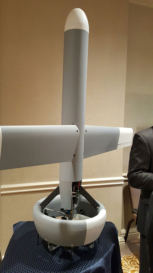
A V-Bat UAV from Martin UAV. Applications include aerial mapping, border patrol, shipboard operations and others.
The Air Force also is developing small drones that can be launched and recovered by a larger aircraft after a mission is complete.
While the meeting was filled with government bureaucrats with the requisite PowerPoint slides detailing how long programs will take, they did say that the services are plowing ahead with autonomous technology that many of their civilian counterparts say are decades away.
Convoy Operations
An Army initiative called Leader Follower includes rudimentary autonomous convoy operations capability with GPS and base mapping systems, autonomous steering and braking. Army program managers say the program is in staffing, but should be approved in a few months.
The follow on to Leader Follower is a full-blown Automated Convoy Operations capability that would allow any manned system, including tanks and mobile artillery, to operate autonomously. Automated Convoy Operations are at least two-to-three years behind the Leader Follower program, Army officials said.
Other Army programs include route clearance systems to defeat underground improvised explosive devices and caches and mine rollers.
With all the new autonomous technology, at least one speaker said the first question should be why an unmanned system is needed at all, given its high cost and long lead times for rollout. “Does the technology enable a [service member] to fight better, or does it just get in the way?” said Lt. Col. Hank Lutz, U.S. Marine Corps joint staff.
Plans to Replace Aging Unmanned Systems
Lt. Gen. Michael Williamson, U.S. Army deputy to the assistant secretary of defense for acquisition, said the service is divesting its aging robotics and drone systems, which means future contracts for defense companies. “In 14 years of war, we have rode this equipment pretty hard,” he said. “We believe in modernization, but also looking to buy new systems, which is a new shift in order to gain a competitive advantage over our enemies, who are leveraging unmanned systems.”
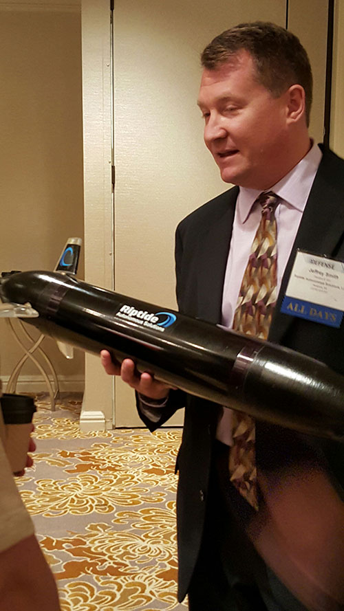
Jeff Smith, president and CEO of Riptide Autonomous Solutions, holds an unmanned undersea vehicle that has GPS sensors and antenna.
The big mantra from the military program managers and senior officials is having an “open architecture” that includes a control segment that works with both manned and unmanned systems. Williamson also echoed the need for standardization, but went further by saying the services should have a list of standards and one place, a facility, to ensure components actually work together.
While the “we want an open architecture” theme was in virtually every speaker’s presentation, one said that there needs to be a balance between the time a product is ready and its interoperability. “The Taliban’s [Program Objective Memorandum] cycle is a lot shorter. Don’t tell me that [your product] is plug and play,” said John Coglianese, U.S. Special Operations Command director, unmanned aerial systems.
DoD Reaches Out to Smaller Businesses, Silicon Valley
Realizing a need to assess new technologies and partner with innovative companies, the Defense Department recently established the Defense Innovation Unit, which is based in the San Francisco Bay area. The office is small with only a few personnel, said George Duchak, who was recently named director.
Duchak acknowledged that some companies suffer from government fatigue in that they see the same presentations over and over. By being out in the Silicon Valley, Duchak’s personnel can be more receptive and listen, rather than talk at companies. His office is made up of people who seek out new technology and vendors, serve as a conduit to local labs and assess companies who want work with the government, among other activities.
“We are kind of in a honeymoon period [with private companies]. It has been interesting finding companies where their patriotism aligns with whether or not they are going to make money,” Duchak said. “Google has been pretty receptive, not so much with Apple.”
Another group, the National Advanced Mobility Consortium, looks to match technology to defense needs for smaller companies looking to do business with the government. “We are trying to show how to engage nontraditional companies,” said Bill Thomasmeyer, National Advanced Mobility Consortium consultant. Thomasmeyer said it’s tough for a small company or individual entrepreneur to go through the complex government procurement cycle. “They are used to Silicon Valley, which has a 90-day cycle. The Federal Acquisition Regulation is 4,000 pages,” he said.
Currently, NAMC has 274 members, a third of which are not defense companies, Thomasmeyer said.
Future of GPS and Location Technology for Unmanned Systems
Virtually all unmanned systems, from drones to autonomous vehicles, use GPS location technology and advanced mapping. As systems evolve, and enemy threats become more sophisticated, new requirements are emerging.
“All of our systems use GPS, but we need to operate in a GPS-denied environment,” said Capt. Aaron Peters, U.S. Navy program manager for expeditionary missions.
Other program managers said what’s also needed is GPS units that feature 3-D navigation for autonomous systems.
In addition to basic positioning and navigation of drones and autonomous vehicles, the Air Force is using location technology to geo-locate damage from shell holes at airfields they use in war zones.
During the first week in September, Rockwell Collins completed Contractor Test and Evaluation flights at Eglin Air Force Base, Fla., for the Common Range Integrated Instrumentation System (CRIIS). The demonstration included ground-to-air uplink of GPS correction messages and network services from multiple data-link towers.
In cooperation with the CRIIS System Program Office (SPO), contractors and the University of Iowa Operator Performance Laboratory (OPL), 13 test flights were conducted using an L-29 from the University of Iowa OPL. Throughout the testing, the high reliability of the CRIIS equipment resulted in all test flights being performed as scheduled. Only a single test flight was scrubbed due to bad weather. All the flights were conducted using production form, fit, function airborne and ground equipment.
The CRIIS program fulfills critical Department of Defense (DoD) requirements to provide Time, Space, Position Information (TSPI) and additional platform test data, while employing a more robust, spectrally efficient data link, including Multiple Independent Levels of Security (MILS). The MILS encryption recently completed certification on the program, and is capable of simultaneously protecting four levels of Top Secret through Unclassified data flowing between aircraft and ground components.
“These flight tests demonstrate the mature, production ready level that the CRIIS program has reached,” said Tommy Dodson, vice president and general manager of Surface Solutions for Rockwell Collins. “Tests were an end-to-end validation of the complete CRIIS system using production representative hardware and software. This testing validated that the next generation of secure, common test and training instrumentation is mature.”
Rockwell Collins is the prime contractor and systems integrator for the next-generation military test range system that will replace the Advanced Range Data System (ARDS) currently in use at major U.S. military test ranges. CRIIS equipment will support a variety of platforms, including advanced fifth-generation aircraft, and implements the DoD’s vision of common test and training infrastructure for improved operational realism.
The following key functions were demonstrated on these flights:
End-to-end system validation with production representative hardware
High confidence in ability to meet TSPI performance requirements
Data-link network ingress after takeoff
Ground-to-air uplink of GPS correction messages and network services from multiple data-link towers
Air-to-ground downlink of TSPI messages
High dynamic scenarios involving a total of 133 dynamic maneuvers representative of flight profiles fighter jets undertake during air combat training
In addition to the multi-level secure ground equipment, the CRIIS flight hardware is configurable in either a pod mounted package or internally mounted on aircraft. This gives CRIIS the flexibility to adapt to use by a wide range of aircraft from all over the world, and the ability to fully integrate those aircraft into complex training scenarios.
Following the completion of CT&E, the CRIIS SPO will conduct Government Test and Evaluation (GT&E) later this year to support a planned final Production Readiness Review in the near future.
There I was, well above Angels 40, sound asleep wearing a positive pressure oxygen mask and helmet with the droning of multiple jet engines in the background for company. Then, I was abruptly awoken by an aircrew member urgently calling my name.
On waking I noticed that it was colder and darker than I remembered when I had nodded off. The only light was that strange ambient light you only experience at high altitudes, and there was zero radio chatter in my helmet headset.
When I reached the cockpit, I noticed the ambient light again because the radar screens were blank, as were all the electronic screens for our multiple sensors, and then it dawned on me. There had been some kind of an electrical failure. I glanced at the navigation displays to determine our position, and to my dismay, discovered they were all blank and lifeless as well. This should not have been, as all navigation and emergency avionics instruments had extensive battery backups.
Then I looked closer and noticed that not only were the screens blank, but the inertial power switches were in the standby position. All kinds of thoughts raced through my mind as the pilot-in-command, easily 20 years my senior (we will call him Bill for brevity) explained that after the fifth and last over-water air refueling things were progressing nominally — until they weren’t. Suddenly, amber and yellow caution lights appeared, followed quickly by red warning lights, all of which warned of imminent power failures of the jet-engine-driven generators. The special mission aircraft we were flying had enormous generators on all engines, so large they precluded thrust reversers on any of the engines. The aircraft needed all that power to function as a mission aircraft, but fortunately needed no electrical power to remain airborne.
We completed the “total loss of electrical power” checklist, and for the time being all was well. The copilot calculated the aircraft could fly for another 10+ hours with IFR reserves using the fuel on board, and from our high altitude could “glide” with engines at idle for a couple hundred miles. So, no worries right?, as one of our Australian exchange pilots liked to say. Of course, there were several worries, the main one being no one knew exactly where we were. Like Daniel Boone we were not officially lost, just a bit bewildered.
Airborne Class
Another aircrew instructor and I were onboard this particular aircraft enroute to what must remain an undisclosed location down under, to teach a class and develop a curriculum on overwater navigation for crews flying reconnaissance aircraft. My apologies for the brevity, but that is all I am allowed to say about the aircraft and our mission to this day.
The aircraft had every bell and whistle you can imagine and then some, but it was essentially an electric aircraft as far as mission and navigation were concerned, and at the moment we were fresh out of that commodity. My instructor colleague and I were about to give out first impromptu overwater navigation class at altitude. We were not yet in extremis, but if we did not do everything exactly right, it might be everyone’s last overwater navigation class.
Back to Basics by Necessity
I had one of my flight bags with basic navigation gear with me on the flight deck and not stowed in the cargo hold, which was not accessible in flight. In that bag I had protractors, rulers, various conversion tables including the critical Aeronautical Almanac and Sight Reduction Tables for Air Navigation, plus an antique but serviceable sextant. The sextant needed to be treated with kid gloves, which is why I had the bag with me rather than stowed in the baggage compartment.
Sextant courtesy of Landfall navigation.
My colleague and I suggested that as an augmented crew, we run through the emergency checklist for total loss of electrical power once again. Then we reviewed the Dash One (aircraft bible) on electrical failures and recommended actions plus all the flight crew actions 30 minutes prior to the power failure. We checked circuit breakers throughout the aircraft including in the mission compartment, the avionics and the mission equipment bays. We found nothing amiss except a plethora of red warning lights that told us nothing new; we were literally in the dark.
The good news was that aerodynamically the aircraft was performing perfectly. Considerable experience with the persnickety nature of emergencies and aircraft electrical systems precluded making any drastic changes. The autopilot was off and the aircrew was hand-flying the aircraft that, when perfectly trimmed, actually required very little effort. That was good, since under even the best scenario we were “feet wet” — over water for at least another seven hours.
Just before the massive electrical failure, the navigator calculated the aircraft was passing the “go-no-go equidistant” point of flight, which on long overwater flights means the aircraft, under nominal conditions and considering the prevailing wind and drift, could proceed to the landing destination but no longer had fuel or endurance to return to a suitable airport nearest the original “feet wet” departure point. In other words, we only had enough fuel to continue to our destination and could not turn around and return to another suitable airport to land. Plus, deviating from our scheduled route and flight plan without being able to notify the flight-following stations meant that if we ditched, no one would be looking for us in the right location. Additionally, politically the number of foreign airports where we could land our type of reconnaissance aircraft were few and far between. We elected to proceed to our original destination.
This was not a democratic process or decision, as the pilot-in-command always has the last say. He is ultimately responsible for the aircraft and crew. But we were all in the same predicament, so after we had each voiced our opinions, the aircraft commander made the correct decision to proceed and to change the aircraft configuration as minimally as possible. This meant we would not try to bring the generators back online until we were over land and within gliding distance of a suitable airport, which by our best guess was seven hours distant.
The aircraft had a RAT, or ram air turbine, for just such emergencies, except that it was not for this emergency. RATs are typically used for short durations, generating power to make emergency radio calls. Once deployed, a RAT could not reliably be re-stowed, and there was no record of anyone having deployed a RAT for more than seven hours. Plus, it would probably affect the handling of the aircraft. No one knew exactly how nor how much drag it would produce, and how it would affect our endurance or emergency glide capabilities. Best to leave the RAT stowed for now. If the engine generators and bus did not come back online once we were over or near land, then we would consider deploying it and making emergency radio contact. While being out of radio contact was not unusual for our type of aircraft, the FAA and its equivalent at our destination would probably be the agencies initially concerned. As a last resort, our parachutes all had survival radios that could be utilized for communications on guard channel — presuming someone was monitoring guard and heard our call.
Older Is Not Necessarily Better
We were straight and level on a heading for our destination, determined from the original flight plan and from weather and atmospheric data more than 48 hours old. We needed real-time or as close to zero age of data as we could manage, and it would have to be generated internally.
The aircrew was a senior crew, but rarely flew over water out of sight of land or out of range of electronic navigation aids. The aircrew was, to put it politely, on average nearly twice the age of my colleague and I, who were qualified overwater aircrew instructors. The aircraft commander was still ultimately in charge, but his comment or charge to us was, “OK guys, you’re the experts, now what?”
Status Quo
As far as arriving at our destination, if the engines continued to run and we continued on this course, without encountering or having to deviate blindly around significant weather, we would eventually make land fall feet dry. We would then hopefully extend the RAT, make radio contact, and explain our predicament to ground control or the country’s Air Defense fighters scrambled to intercept us for violating their Air Defense Identification Zone (ADIZ) without the proper radio calls. This is where the handheld radios in our parachutes would come in handy, explaining on guard channel to the fighter/interceptor pilots that we were allies and good guys and just experiencing a communications failure. All of which would be embarrassing and potentially fraught with dangerous consequences, but which could be avoided if the power miraculously came back on or if we followed the emergency “communication out” ADIZ penetration procedures for that particular country.
These emergency procedures, while almost global in nature, were well known in theory but rarely, if ever, practiced by flight crews. They consisted of: flying within a prescribed 10-mile wide corridor, arriving at the ADIZ penetration point on course and on time, and then flying a specific triangular pattern for three consecutive iterations, while listening on guard, if possible, and then proceeding to our original destination as planned, possibly still “comm out,” flying a communications out, VFR (visual) approach and landing as planned. Such an arrival might create a minor stir, but we would be seen as obeying the international flight rules and hopefully no one would be chastised or court-martialed.
Do We Have a What?
To accurately fly the ADIZ penetration procedures, we needed to know where we were, how fast we were flying (our groundspeed), and what factors were affecting our flight planned heading. Since it was still daylight, our best bet was to use “back to basics” navigation techniques to determine our groundspeed, and then as the stars appeared, we could better determine our position and refine our heading.
The crew regarded me with some skepticism as they realized I intended to use an old-fashioned sextant to determine the speed and heading and then navigate a multi-hundred-million-dollar modern reconnaissance aircraft. An aircraft with multiple Doppler receivers, inertial navigators, pinpoint radars, satellite communications, racks for a GPS receiver that had yet to be installed and an avionics suite that was second to none at the time. I proposed we navigate for seven hours with an obviously antique handheld brass sextant that I pulled carefully out of a velvet pouch stowed in my flight bag. And I would have done just that, if I had not realized that this aircraft also had a sextant port when the flight engineer mumbled something about a dusty old sextant case being strapped down in the avionics bay.
Within minutes, the old sextant case was opened to reveal a pristine sextant still wrapped in depot preservatives. It may have literally never been used since it was put on the aircraft, probably as a safety afterthought. Certainly no one on the crew had ever used one on this aircraft, and the senior navigator had not used one since navigator school at Mather Air Force Base in California. Since there was no electrical power, we were not sure the sextant would work or if the displays would be readable. After checking it over, we pushed it through the sextant port and were rewarded with a good pressure seal. We found a spare D-cell battery to power the sextant in emergency mode, hooked up that cable and were in business. General Curtis LeMay would have been proud.
Non-Traditional Navigation Sensors
For those of you not familiar with celestial navigation, or using a sextant with the accompanying Air Almanac Star Reduction Tables (remember, the Sun is a star) basically it goes something like this:
“Celestial navigation is the ancient art and science of position fixing that enables a navigator to navigate without relying on dead reckoning, to determine their position. Celestial navigation uses ‘sights,’ which are angular measurements taken between a celestial body and the visible or artificial horizon. The sun is most commonly used, but navigators also use the moon, a planet or one of 57 other navigational stars whose coordinates are tabulated in the Nautical and Air Almanac.
“Celestial navigation sights locate one’s position on or above the Earth. At a given time, any celestial body is located directly over one point on the Earth’s surface. The latitude and longitude of that point is known as the celestial body’s geographic position (GP) or sub-point, which can be determined from tables in the Air Almanac.
“The measured angle between the celestial body and the visible or artificial horizon is directly related to the distance between the celestial body’s GP or sub-point and the observer’s position. After some computational sight reductions, this measurement is used to plot a line of position (LOP) on a navigational chart, the observer’s position being somewhere on that line. Most navigators use sights of three to five stars and plot the resulting LOP(s) to minimize the chance for error.”
To begin the process, we needed to know time as exactly as possible, the date where we were located, our altitude and, if possible, an approximation of our location and direction of flight. All that information is provide by crewmember timepieces and basic navigation instruments that don’t rely on electrical power. You enter the tables and complete the pre-computation worksheet with the derived data, which you dial manually into the collimators of the sextant. Then with our bubble sextant representing the horizon, you place the Sun in the middle of the bubble and collimate on it for two minutes, read the resulting number off the sextant, convert it to a distance from the celestial bodies’ known sub-point, and that is your LOP. Since we were traveling in a southwesterly direction, the Sun provided a speed or velocity LOP. It would not determine our location with any certainty, but would provide a reliable estimation of our speed over the Earth.
We knew our basic air speed from the onboard instruments that were still working, but we needed to know our ground speed, which is affected by head, tail or cross winds. Two such Sun sightings over a period of 10 minutes multiplied by 6 gave us our ground speed, and when compared to our airspeed told us that we had a 40-knot tailwind, likely due to a forecast large low-pressure system behind us. Consequently, we would be drifting to the left, which would cause us to steer right a few degrees of our intended course, since the planned tail wind was only 20 knots, not 40. Now we knew our groundspeed and refined our ETA (estimated time of arrival) at the ADIZ penetration point. We conducted Sun shots and calculations every 30 minutes until the Sun set and the stars were visible. Shooting and plotting multiple stars for positions is just a bit more complicated and time consuming, but because it results in an actual position, rather than a speed line, it is much more valuable.
We had additional sources of data as well, which surprised the senior crew — whom we were essentially instructing in the basics of emergency overwater navigation. We plotted the best dead-reckoning line of position based on the flight plan and last known position. Then we plotted several more lines of position based on temperature, ground speed and pressure readings. This is a technique rarely used by navigators today, but one that helps you double-check your assumptions and flight planning data. In the Northern Hemisphere, a low pressure system behind you when heading southwesterly will nominally result in a tailwind and drift to the left of your course, based on the old mnemonic high up right and low down left, just as longitude and latitude mathematical values are based on the mnemonic East is least (minus) and West is best (plus). Similarly, if the temperature is rising over time, then you are most likely drifting to the right. If it decreases, you are likely drifting to the left. Lows are typically cooler than highs. If the barometric pressure is rising, then you are drifting right, and if it lowers, then you are drifting left. These are not all hard and fast rules — you can be on the backside of a major weather system and experience all these phenomenon — but if you are not being tossed about in the middle of a major thunderstorm, these mnemonics can save your life.
Normally a navigator will take one sextant shot per hour while averaging wind, pressure and temperature data over the same time. Given our dire circumstances, we calculated pre-comps and shot planets and stars continuously, on the average of three sights per hour, and took temperature and pressure readings every 10 minutes for the next 7 hours. Arriving at the ADIZ penetration point, we flew our three triangular patterns and were shortly thereafter intercepted by a Canberra aircraft that was conveniently in the area (it turns out our hosts had been expecting us and determined from the radio silence that something was amiss). The Canberra pilot informed us on guard channel (those wonderful parachute radios proved a godsend) that he would lead us to our destination. Thankfully, the weather was VFR (visual flight rules). We followed him down on a visual approach to our destination, and when he broke off in the pattern, we landed uneventfully.
We attempted to bring the engine generators online 30 minutes before the predicted ADIZ point without success. However, in the process the battery connections were re-energized and the inertial devices woke up. Because an airborne initialization required more than an hour’s time, we used them as a groundspeed reference only. Frankly, all the warning messages and flashing lights in the otherwise dark cockpit were almost more of a distraction than help.
Debrief
During the mission debrief, the maintenance crews informed us that a faulty sensor and a computer glitch had caused the power problems. Our generators were fine, but the faulty sensor and computer software had combined to shut down all generators.
Lessons Learned
Looking back on this flight many years later, in retrospect I believe we made all the right decisions. We continued to our destination and did not attempt to fix a major problem over water as long as the basic airframe and engines were doing their job. We followed our flight plan, and if we had ditched, we would have hopefully been found along our route of planned flight.
We made use of the instruments and crew-member capabilities on hand. We used a navigation method vetted over literally hundreds of years with the most modern versions of that equipment available. The crew learned how to use basic data almost always available on any aircraft, powered or not, to lay down not one but multiple lines of position.
Today, if the same scenario came about, the basic decisions would be the same, except that crew members would merely pull out their pocket GPS navigation devices, probably mostly iPhones, and using a power-saving battery plan, navigate their way to their destination. The difference is that the data — weather, groundspeed, altitude, heading and ETA, even to various waypoints — would be instantly available, and it would be accurate to within feet and nanoseconds, not miles and minutes. They might even have been able to call ahead.
Inertial Inertia
Contrary to what some in the Defense Department have been saying, the inertial devices onboard would have been just as ineffective if this scenario was repeated today. The critical and operational limiting caveats that most laymen and even some military users miss about individual inertial devices is that they are intrinsically dumb devices that experience drift and bias phenomena that are not always predictable. Inertial units do not know when or where they are until they are told. Even after they are told, if the inertial units lose power without a battery backup, they need to be told time and time again when and where they are. GPS performs this function very well, and together the two systems are almost the perfect navigation combination.
Without an internal clock and coordinate system (chip-scale atomic clocks [CSAC] will work only after they are initialized and told what time it is, a function more often than not performed by GPS today and in the foreseeable future), an inertial device will not show you where you are on a map display or in any discernible or chartable coordinates. An inertial device, while it is superbly equipped to measure movement in every axis, is basically a three-dimensional device. Inertial units detect up from down, left from right, and acceleration or de-acceleration, but they do not detect changes in time or know their starting, way or endpoints in discernible coordinates without being told. So, yes, Mr. Secretary, it would be great to have an inertial that would run for a thousand years, but first you need the miniaturized atomic reference systems, power systems and coordinate determination systems that will run that long as well.
In other words, we need an inertial system that is a system of systems, which today are ideally comprised of CSAC and GPS devices with a laser gyro. In the not too distant future, a cold atom interferometer MEMS (microelectromechanical system) inertial with CSAC and GPS all backed up by eLORAN is probable. That, however, is a story for another time.
Until next time, wax nostalgic — dig out your old sextant and take a sighting. Until then, happy navigating, and remember that GPS is brought to you courtesy of the United States Air Force.
The latest variant of the Excalibur precision-guided projectile will be used by armies and be available for naval ships.
The Netherlands Ministry of Defense is adding Raytheon Company’s Excalibur Ib artillery rounds to its arsenal under a previously announced foreign military sales agreement, underscoring growing international interest in the precision-guided projectile.
The Netherlands is the second Excalibur lb customer in Europe after Sweden, the U.S. government’s development partner for the 155-mm round. Deliveries are expected to begin later this year.
“The Netherlands joins a growing list of nations acquiring this highly sophisticated artillery munition, which uses GPS guidance to provide accurate, first-round effects capability at extended ranges,” said Mark Hokeness, Raytheon’s Excalibur program director. “When fired from the Dutch PzH 2000 artillery system, Excalibur can fly up to 50 kilometers, score a direct hit and deliver lethal effects in all types of weather and battlefield conditions.”
A Dutch Panzerhaubitze 2000 (PzH 2000) fires a round in Afghanistan. (Image courtesy Dutch Ministry of Defense)
The U.S. Army has determined Excalibur Ib is fully compatible with the PzH 2000, a self-propelled howitzer produced in Germany and fielded by several nations.
The Excalibur precision-guided, extended-range projectile uses GPS guidance to provide accurate, first-round-effects capability in any environment. Excalibur’s level of precision delivers a major reduction in the time, cost and logistical burden associated with using other artillery munitions. Excalibur has been fielded by the U.S. Army, Marines and several international military forces.
Excalibur Facts
Combat-proven: Nearly 770 Excalibur rounds have been fired in combat with exceptional accuracy and lethality.
Precise: Excalibur consistently strikes less than two meters from a precisely-located target, Raytheon said.
Safe: Excalibur’s precision avoids collateral damage and has been employed within 75 meters of supported troops.
Affordable: With its first round effects, Excalibur reduces total mission cost and time and the user’s logistics burden, according to Raytheon.
Evolving: Raytheon has demonstrated a dual-mode GPS/semi-active laser seeker Excalibur variant to compensate for target location error, maintain precision in GPS denied or degraded environments, and enable engagement of relocated or moving targets.
Navies: With Excalibur N5, navies will be able to deliver extended range, precision naval surface fires from existing 5-inch/127-mm guns.
On Aug. 24, David W. Madden joined Lockheed Martin’s Military Space Line of Business, where he will be responsible for international military satellite communications (MILSATCOM), based in Denver.
Madden served as the GPS Wing Commander at the Space & Missile Systems Center (SMC) in Los Angeles, Calif., before retiring from the U.S. Air Force in May 2010. From June 2010 until his new appointment, Madden served as director of the Military Satellite Communications Systems Directorate at SMC.
In his new role, Madden will oversee Lockheed Martin’s efforts to further enhance the company’s relationships with international allies and customers, and to grow the MILSATCOM portfolio.
At the Military Satellite Communications Systems Directorate at SMC, Madden was responsible for acquiring, deploying and sustaining the $42 billion MILSATCOM portfolio of programs which consists of ACAT I and II programs including the Defense Satellite Communications System, Milstar, Global Broadcast Service (GBS), the Wideband Global SATCOM, the Advanced EHF program, the Enhanced Polar System, the Command and Control System-Consolidated and associated Terminals programs.
Madden entered the Air Force in 1980 after graduating from the Virginia Military Institute. He gained experience in systems engineering, technical intelligence, and command and control and space systems requirements, development, fielding and operations. In addition, he has commanded a Space Operations Squadron and a Material Acquisition Group before the GPS Wing.
Dr. Todd Bacastow, PSU, talked with me about geointelligence in the broader business community. See the full interview below.
Time for a Revolution — or Evolution
In July at GEOINT 2015 I was talking with long-time colleague Dr. Todd Bacastow. Many of you may know him as the retired Army Lieutenant Colonel and Penn State professor heavily involved in the Geospatial Intelligence Certificate program and the lead for the GEOINT Massive Open Online Course (MOOC) series focused on GEOINT. He proposed a topic for my column that struck a nerve with me since I and others had danced around the potentially heretical issue — is it time to open and expand the GEOINT community to a larger audience?
As retired military officers, Todd and I share a common overarching loyalty and desire to do what we can to make life better and more survivable for our colleagues on active duty. GEOINT has certainly helped by providing detailed and timely actionable intelligence for those at the tip of the spear. However, can we do even better? Most assuredly yes!
The most advanced tip of the spear is our Special Operations community. Manycivilians picture Special Operations members as knuckle-dragging Rambos shooting up the countryside, but nothing could be further from the truth. In fact, they are without doubt the most intelligent, observant and capable people on our DOD team. They’ve learned over decades of experience that they can complete their missions and accomplish far more by winning the hearts and minds of individuals they deal with. Doing that requires hours, days and weeks of due diligence reviewing intelligence and any crumb of information that will make a difference.
Gone are the days of just looking at aerial photography. Now we have countless sources and types of imagery, analytics, tracking, social media, signals and human intelligence. Putting that complex slurry of information together into solid actionable intelligence is everyone’s goal, and the business community is no exception.
Looking around the GEOINT Expo, I saw countless three-letter agency reps, military and homeland security personnel. There were an equal number of defense contractors and related business personnel, but everything was focused on military/security applications. Other than Pitney Bowes showing MapInfo, primarily a business-focused GIS, there were few exhibitors showing technology not aimed at the traditional GEOINT community.
Our military and other first responders have tasks and responsibilities that are serious, complex and becoming more challenging. Limiting the talent pool and body of knowledge to only the narrow GEOINT community is not something we can afford to do. The creative talent found in the broader business community is too valuable to neglect.
Watch the video interview I shot at GEOINT 2015 with Bacastow and Dennis Bellafiore, Ph.D., both of Pennsylvania State University.
My chief concern is bringing the business community in with the understanding that this would be an open and sharing environment. My first real use of GIS after retiring from the Navy in 1993 were some business applications, mostly site studies and trade area analysis. In those early days, GIS grew rapidly within the business community. There were trade shows aimed at business applications of GIS, and even a publication called Business Geographics. Much to my surprise, Business Geographics and associated trade shows died out after only a few years. Some said that everyone learned all there was to learn! I don’t think so. A more likely reason was that the geospatial technology gave businesses a competitive edg.e so there was little incentive to expose trade secrets. Everyone wanted to learn about GIS, but few wanted to open their own kimono.
Would an all-inclusive GEOINT organization run into the same fate? Perhaps if we promote it as “we are all in the same boat” and this is your opportunity to help those at the “tip of the spear.” In this age of cyber warfare and corporate espionage, perhaps we might be able to make this happen by promoting mutual aid and security. I think USGIF and most geospatial industry partners would be interested and very supportive of the idea. But most important, can you imagine the explosion of ideas and the benefits to all geospatial users.
Todd, Dennis and I would really appreciate your opinion. Please leave comments below.
Public Works and Government Services Canada (PWGSC) has selected NovAtel’s GAJT-AE antenna electronics for testing on Canadian Army platforms. The GAJT-AE, developed in Calgary at NovAtel’s global headquarters, is a GPS anti-jam solution suitable for small and weight constrained applications. The testing is being conducted through PWGSC’s Build in Canada Innovation Program (BCIP).
PWGSC will procure a number of GAJT-AE’s on behalf of the Department of National Defence (DND). The Director Land Requirements (DLR), with the assistance of the Quality Engineering Test Establishment (QETE), will oversee all testing on DND’s behalf. Field testing is expected to take place in the latter half of 2015 at 4th Canadian Division Support Garrison Petawawa.
The testing will analyze the performance of GAJT-AE on Canadian Army equipment in operational conditions to confirm the suitability and robustness of the NovAtel technology for this role. The process is expected to be completed by the end of March 2016.
GAJT is a null-forming technology that negates jammers, ensuring the satellite signals necessary to compute position and time are always available. Three categories of GAJT are manufactured by NovAtel:
GAJT-710ML: for use with military land vehicles, networks and timing infrastructure
GAJT-710MS: for marine vessels, from small boats to capital ships
GAJT-AE: for use with an external antenna in size and weight constrained applications
“NovAtel has had great success working closely with the Canadian Army on the previous round of BCIP,” said Jason Hamilton, NovAtel’s vice president of marketing. “It is essential to have military users test our products in operational scenarios. We look forward to the valuable feedback that the Canadian Army testing of GAJT-AE GPS anti-jam antenna electronics will provide. NovAtel will use this feedback to continue developing products in support of Canada and its Allied partners.”
The BCIP was created by the Government of Canada to strengthen Canadian innovation. The program offers procurement and testing of pre-commercialized products and services, at a late stage of development. The BCIP:
Bridges the “pre-commercialization gap”
Supports Canadian suppliers by connecting innovators and government users and by testing innovations
Provides real-world evaluation of pre-commercial goods and services
Improves the efficiency and effectiveness of government operations.