By Karen Parrish, DoD News, Defense Media Activity
An Air Force program that will provide a vital new command system for the global positioning system satellite constellation in the shortest time possible will continue despite cost growth, Defense Department officials have confirmed.
Frank Kendall, undersecretary of defense for acquisition, technology and logistics, announced Oct. 12 the continuation of an over-cost program supporting the global positioning system. Here, Kendall is briefed by Jose Romero-Mariona on cybersecurity science and technology during Kendall’s visit to Space and Naval Warfare Systems Center Pacific in San Diego, Aug. 24. (Navy photo by Aaron Lebsack)
The next-generation operational control system, known as OCX, reached what is called a Nunn-McCurdy breach on June 30. The Nunn-McCurdy provision applies to weapons programs and requires the military services to notify Congress if a program’s cost per unit increases 25 percent or more over the current baseline estimate.
But well before June 30, defense acquisition experts began working with Raytheon, the contractor for OCX, to resolve program issues. In December 2015, Undersecretary of Defense for Acquisition, Technology and Logistics Frank Kendall directed in-depth quarterly reviews, including a series of “deep dives” overseen by him. Certification activities began in July 2016, and culminated with Kendall certifying the program to Congress yesterday, thus allowing the program to continue.
Next-Generation GPS
James MacStravic, acting assistant secretary of defense for acquisition, discussed OCX and its importance with DoD News.
“This is what the controllers on the ground are going to use to make sure that all the satellites are talking to each other, that they’re exchanging the same information [and] that they’re where they’re supposed to be,” he said.
The OCX system will command all modernized and legacy GPS satellites, manage all civil and military navigation signals and provide improved cybersecurity and resilience for the next generation of GPS operations.
The OCX program includes the following phases: Block 0, to perform launch and checkout of GPS-III satellites; Block 1, to command all navigation signals, including the modernized military signal; and Block 2, for additional enhancements to signal assurance and navigation warfare capabilities. The ground segment capability not only supports military forces, but also civil, commercial and scientific uses. The current total program cost estimate for OCX is $5.46 billion.
OCX will consist of:
A master control station and alternate master control station;
Dedicated monitor stations;
Ground antennas;
GPS system simulator; and
Standardized space trainer
Turning the Program Around
Defense officials said factors in the OCX cost growth included late recognition of the magnitude of information assurance work that was required, concurrent systems engineering that drove significant rework, inconsistent configuration management of the program baselines, immature software and a lack of automation across the program. These issues drove schedule slips, which in turn increased the cost of the program, leading to the breach.
MacStravic described the efforts defense officials and Raytheon have made to turn the program around. He emphasized the work has included the personal involvement of Kendall, Air Force Secretary Deborah Lee James and Raytheon’s chief executive officer.
“What we spent the summer doing was making sure … does this program have the right management resources, the right financial resources and an appropriate schedule to succeed?” MacStravic said.
Officials report that after three on-site quarterly reviews, Kendall’s assessment is that Raytheon is making substantial progress on the program, but that some additional schedule increase has occurred and that there is risk of more schedule increases.
Progress has been sufficient to support certification under the Nunn-McCurdy process, officials said. Kendall’s office will continue the OCX quarterly reviews begun in March 2016, which to date have included the secretary and principal deputy acquisition chief of the Air Force, the program executive officer and Raytheon’s chief executive officer.
The alternatives to certifying the program included several options, including program termination, but this was deemed simply unworkable, due to the extended time it would require to design and field a new ground system for the vital GPS III network.
According to officials, the future of the OCX program will depend upon Raytheon’s ability to demonstrate that it can deliver the needed capability to the Air Force at acceptable cost and within an acceptable time.
The GPS modernization funding picture cannot be called bright, yet neither can it be characterized as dim. While big money for big projects appears hard to come by, the U.S. government and military offer many smaller allocations to help fill the chinks in GPS armor. Such initiatives concern jamming, PNT solutions in GPS-denied environments and other conundrums. A run of Small Business Innovation Research (SBIR) requests for proposals have appeared recently.
A caveat: the U.S. government has some history of soliciting innovation from small firms, then awarding continuation of the work to big, established government contractors, under the rationale that these companies have capacity to carry out large-scale manufacturing.
The current batch of RFPs specify Phase I contracts that will, by statute, all go to small businesses, as will Phase II. The problem then — for these contract winners —is that follow-on work typically goes to large primes.
Jamming. The objective of a tender issued in December of last year, with a closing date of Feb. 17, is to “develop a ground-based GNSS Jammer Location capability utilizing a single GNSS receiver capable of estimating the position of a GNSS jammer within 100 meters, and estimating jammer position within 10 meters when networked with other sensors.”
The Department of Defense (DoD) continues: “Although many effective techniques exist, they primarily rely on airborne equipment, using either high demand, low density assets or dedicated aircraft such as unmanned aerial vehicles (UAVs). To enhance the future Navwar capabilities of DoD, a ground-based capability that can operate in urban canyons or mountainous terrain will provide a significant improvement to overarching Navwar capability. In some cases, jammers may be deployed on mobile ground vehicles in an urban environment, making them difficult to detect and track.”
DoD wants you to exploit opportunities offered by multipath and controlled radiation pattern antennas (CRPAs) to detect and locate 100-watt mobile jammers.
“Four alternatives should be evaluated: 1) a single GNSS receiver without a CRPA, 2) a single GNSS receiver with a CRPA, 3) two or more networked receivers without a CRPA, and 4) two or more GNSS receivers with a CRPA. For each alternative, assess the location accuracy, cost (both recurring and nonrecurring), and suitability for integrating in a ground vehicle.”
The DoD also offers stimulus funding for a range of other problems seeking a solution. The closing date is Feb. 17 for all of these, so sharpen your pencils and put on your thinking caps.
Contracts and Future Work. Concerning the follow-on work issue, Alison Brown, Co-Chair of the Government Contracting Working Group in the Small Business Administration’s (SBA’s) Regulatory Fairness Board, has written a white paper, “SBIR Regulatory Enforcement Issues,” available here. In it, she reviews the degree to which DoD complies with existing law. Congress has enacted Sec. 5108, mandating that “To the greatest extent practicable, Federal agencies and Federal prime contractors shall issue Phase III awards relating to technology, including sole source awards, to the SBIR and STTR award recipients that developed the technology.”
Brown states that “currently there is no effective recourse for small businesses or avenues for enforcement of the current SBIR Regulations within the DOD and other government agencies.” She recounts in the paper her own experience, as founder and CEO of NAVSYS Corporation.
NAVSYS developed and fielded a precision GPS navigation capability, Talon NAMATH, under a Phase III SBIR contract to Air Force Tactical Exploitation of National Capabilities (TENCAP). The systems was declared “provisionally operational” and used in theater in Operation Iraqi Freedom. Although the Talon NAMATH system was declared a huge success in theater, the follow-on contract for a fully operational system was awarded to Boeing.
Brown is also a longtime member of GPS World’s Editorial Advisory Board.
At Unmanned Systems Defense, warfighters had the opportunity to learn about new technologies from government contractors and see demos in the exhibition hall. (PRNewsFoto/AUVSI)
ARLINGTON, Va. — Despite shrinking defense budgets, existing and emerging worldwide threats will make robotic and autonomous systems’ development important for decades, said officials at the Unmanned Systems Defense 2015 conference held here Oct. 27-29.
Because America has been at war for more than 14 years, unmanned technology has been developing at a rapid rate, perhaps even faster than emerging autonomous commercial systems. The replacement of even manned aircraft has some in the military establishment wary, but others know it’s only a matter of time before most vehicles, surface ships and aircraft are unmanned.
Navy Secretary Ray Mabus said that the F-35, which has been controversial because of its cost and capabilities, may be the last manned fighter aircraft.
Mabus acknowledged the rise in autonomous vehicles not only in the military, but in the civilian world. “Our grandchildren may never have to drive a car. I can’t wait for driverless cars,” he said.
The Navy is so high on unmanned systems that it recently named retired Marine Brig. Gen. Frank Kelley as deputy assistant secretary of the Navy for unmanned systems.
Like the other services, the Navy is experimenting with aviation systems that are inexpensive and small. It is developing swarming drones that are designed to overwhelm a target. Mabus said one of the cool drones that the Navy is developing is called Kraken, which operates underwater, then explodes past the surface to operate in the air.
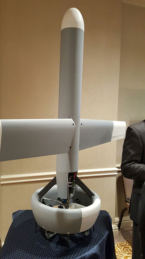
A V-Bat UAV from Martin UAV. Applications include aerial mapping, border patrol, shipboard operations and others.
The Air Force also is developing small drones that can be launched and recovered by a larger aircraft after a mission is complete.
While the meeting was filled with government bureaucrats with the requisite PowerPoint slides detailing how long programs will take, they did say that the services are plowing ahead with autonomous technology that many of their civilian counterparts say are decades away.
Convoy Operations
An Army initiative called Leader Follower includes rudimentary autonomous convoy operations capability with GPS and base mapping systems, autonomous steering and braking. Army program managers say the program is in staffing, but should be approved in a few months.
The follow on to Leader Follower is a full-blown Automated Convoy Operations capability that would allow any manned system, including tanks and mobile artillery, to operate autonomously. Automated Convoy Operations are at least two-to-three years behind the Leader Follower program, Army officials said.
Other Army programs include route clearance systems to defeat underground improvised explosive devices and caches and mine rollers.
With all the new autonomous technology, at least one speaker said the first question should be why an unmanned system is needed at all, given its high cost and long lead times for rollout. “Does the technology enable a [service member] to fight better, or does it just get in the way?” said Lt. Col. Hank Lutz, U.S. Marine Corps joint staff.
Plans to Replace Aging Unmanned Systems
Lt. Gen. Michael Williamson, U.S. Army deputy to the assistant secretary of defense for acquisition, said the service is divesting its aging robotics and drone systems, which means future contracts for defense companies. “In 14 years of war, we have rode this equipment pretty hard,” he said. “We believe in modernization, but also looking to buy new systems, which is a new shift in order to gain a competitive advantage over our enemies, who are leveraging unmanned systems.”
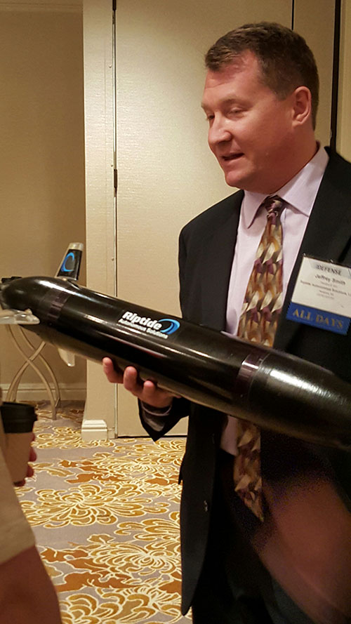
Jeff Smith, president and CEO of Riptide Autonomous Solutions, holds an unmanned undersea vehicle that has GPS sensors and antenna.
The big mantra from the military program managers and senior officials is having an “open architecture” that includes a control segment that works with both manned and unmanned systems. Williamson also echoed the need for standardization, but went further by saying the services should have a list of standards and one place, a facility, to ensure components actually work together.
While the “we want an open architecture” theme was in virtually every speaker’s presentation, one said that there needs to be a balance between the time a product is ready and its interoperability. “The Taliban’s [Program Objective Memorandum] cycle is a lot shorter. Don’t tell me that [your product] is plug and play,” said John Coglianese, U.S. Special Operations Command director, unmanned aerial systems.
DoD Reaches Out to Smaller Businesses, Silicon Valley
Realizing a need to assess new technologies and partner with innovative companies, the Defense Department recently established the Defense Innovation Unit, which is based in the San Francisco Bay area. The office is small with only a few personnel, said George Duchak, who was recently named director.
Duchak acknowledged that some companies suffer from government fatigue in that they see the same presentations over and over. By being out in the Silicon Valley, Duchak’s personnel can be more receptive and listen, rather than talk at companies. His office is made up of people who seek out new technology and vendors, serve as a conduit to local labs and assess companies who want work with the government, among other activities.
“We are kind of in a honeymoon period [with private companies]. It has been interesting finding companies where their patriotism aligns with whether or not they are going to make money,” Duchak said. “Google has been pretty receptive, not so much with Apple.”
Another group, the National Advanced Mobility Consortium, looks to match technology to defense needs for smaller companies looking to do business with the government. “We are trying to show how to engage nontraditional companies,” said Bill Thomasmeyer, National Advanced Mobility Consortium consultant. Thomasmeyer said it’s tough for a small company or individual entrepreneur to go through the complex government procurement cycle. “They are used to Silicon Valley, which has a 90-day cycle. The Federal Acquisition Regulation is 4,000 pages,” he said.
Currently, NAMC has 274 members, a third of which are not defense companies, Thomasmeyer said.
Future of GPS and Location Technology for Unmanned Systems
Virtually all unmanned systems, from drones to autonomous vehicles, use GPS location technology and advanced mapping. As systems evolve, and enemy threats become more sophisticated, new requirements are emerging.
“All of our systems use GPS, but we need to operate in a GPS-denied environment,” said Capt. Aaron Peters, U.S. Navy program manager for expeditionary missions.
Other program managers said what’s also needed is GPS units that feature 3-D navigation for autonomous systems.
In addition to basic positioning and navigation of drones and autonomous vehicles, the Air Force is using location technology to geo-locate damage from shell holes at airfields they use in war zones.
During the first week in September, Rockwell Collins completed Contractor Test and Evaluation flights at Eglin Air Force Base, Fla., for the Common Range Integrated Instrumentation System (CRIIS). The demonstration included ground-to-air uplink of GPS correction messages and network services from multiple data-link towers.
In cooperation with the CRIIS System Program Office (SPO), contractors and the University of Iowa Operator Performance Laboratory (OPL), 13 test flights were conducted using an L-29 from the University of Iowa OPL. Throughout the testing, the high reliability of the CRIIS equipment resulted in all test flights being performed as scheduled. Only a single test flight was scrubbed due to bad weather. All the flights were conducted using production form, fit, function airborne and ground equipment.
The CRIIS program fulfills critical Department of Defense (DoD) requirements to provide Time, Space, Position Information (TSPI) and additional platform test data, while employing a more robust, spectrally efficient data link, including Multiple Independent Levels of Security (MILS). The MILS encryption recently completed certification on the program, and is capable of simultaneously protecting four levels of Top Secret through Unclassified data flowing between aircraft and ground components.
“These flight tests demonstrate the mature, production ready level that the CRIIS program has reached,” said Tommy Dodson, vice president and general manager of Surface Solutions for Rockwell Collins. “Tests were an end-to-end validation of the complete CRIIS system using production representative hardware and software. This testing validated that the next generation of secure, common test and training instrumentation is mature.”
Rockwell Collins is the prime contractor and systems integrator for the next-generation military test range system that will replace the Advanced Range Data System (ARDS) currently in use at major U.S. military test ranges. CRIIS equipment will support a variety of platforms, including advanced fifth-generation aircraft, and implements the DoD’s vision of common test and training infrastructure for improved operational realism.
The following key functions were demonstrated on these flights:
End-to-end system validation with production representative hardware
High confidence in ability to meet TSPI performance requirements
Data-link network ingress after takeoff
Ground-to-air uplink of GPS correction messages and network services from multiple data-link towers
Air-to-ground downlink of TSPI messages
High dynamic scenarios involving a total of 133 dynamic maneuvers representative of flight profiles fighter jets undertake during air combat training
In addition to the multi-level secure ground equipment, the CRIIS flight hardware is configurable in either a pod mounted package or internally mounted on aircraft. This gives CRIIS the flexibility to adapt to use by a wide range of aircraft from all over the world, and the ability to fully integrate those aircraft into complex training scenarios.
Following the completion of CT&E, the CRIIS SPO will conduct Government Test and Evaluation (GT&E) later this year to support a planned final Production Readiness Review in the near future.
On June 3, Raytheon demonstrated the advanced capabilities of the GPS Next Generation Operational Control System (GPS OCX) to key U.S. Department of Defense (DoD) and other stakeholders through a series of realistic operational demonstrations.
The demonstrations, which incorporated software that will be delivered with the Launch and Checkout System, validated how automation will improve system efficiency and effectiveness.
GPS OCX is the ground-based command and control system that will manage GPS satellites with significantly improved accuracy and precision, while providing unprecedented levels of cyber protection.
“These successful demonstrations incorporating actual GPS OCX software reflect Raytheon’s significant and continuing progress on this program and the growing maturity of this very complex system,” said Dave Wajsgras, president of Raytheon’s Intelligence, Information and Services. “Once delivered, this pathfinding, cyber-hardened ground system will significantly enhance the capabilities GPS brings to military, civil and commercial users worldwide,” said Wajsgras.
The demonstration provided DoD and other stakeholders with a look at how OCX will automate many tasks currently performed manually, resulting in reduced opportunities for error and increased operational tempo for delivering military and other applications, Raytheon said.
Raytheon demonstrated the benefits of OCX in providing new high-power, jam-resistant military signal known as M-code, as well as the system’s unprecedented cyber automation, detection and response capabilities.
Raytheon is installing the Block 0 Launch and Checkout System (LCS) hardware at Schriever Air Force Base. LCS software, which includes the cyber-hardened infrastructure for OCX Block 1, is in the qualification test phase and is on track for delivery in mid-2016.
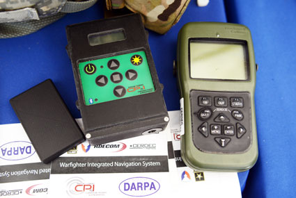
The Warfighter Integrated Navigation System, center, uses inertial systems to determine a Soldier’s location in the absence of a GPS signal. On the left, a smaller version of WINS. On the right, the Defense Advanced GPS Receiver, which soldiers use now for position, navigation, and timing. All three devices were on display at the DOD Lab Day, May 14, at the Pentagon. (Photo: U.S. Army/C. Todd Lopez)
When GPS satellites can’t be seen due to dense jungle canopy, or they are blocked due to enemy interference, soldiers will still be able to track their location digitally using the Warfighter Integrated Navigation System (WINS), a device now under development at the Communications Electronics Research Development and Engineering Center (CERDEC).
During the U.S. Department of Defense Lab Day held May 14 at the Pentagon, CERDEC researcher Osie A. David explained how the technology behind WINS will one day be transitioned to an Army program manager to bring assured navigational capability to soldiers.
The WINS is a device small enough to carry in a soldier’s cargo pocket, about half the size of a pack of cigarettes.
“It’s got a number of inertial sensors, such as a pedometer and an accelerometer, things you will find on your cell phone but of a higher quality,” he said. “Even if the enemy is denying you GPS or the terrain is, you can still get known location on here so it will show up on your Nett Warrior device or your command and control system.” The Nett Warrior is an integrated dismounted situational awareness and mission command system for use by leaders during combat operations, using advanced navigation and information sharing capabilities to allow for faster and more accurate decisions during the tactical fight.
The Nett Warrior
Those inertial sensors will calculate an offset from the last-known location using footsteps taken, speed, acceleration and time, for instance. The device even has way to measure altitude. “It’s got a pressure reader so it knows if you are on the third floor or first floor of a building,” David said.
The WINS isn’t perfect. As time goes by without a new GPS signal, its estimate of current location will degrade. But the device provides for the user an estimate of its own miscalculation. “After a time, it’ll show you a circle radius for the error range,” he said. “It’s still better than having no GPS at all.”
David said knowing location is everything in combat, and the WINS, or a follow-on system that uses technology from WINS, will make sure that soldiers have that no matter what happens to GPS.
“Say we go to Southeast Asia and I’m in the middle of the jungle. There are not a lot of good landmarks. I’m navigating around and I lose the GPS because with the triple-canopy jungle, the GPS can’t penetrate that. I don’t know where I am on the map, so I’m in a bad situation. If I want to know exactly where I am so I can call for reinforcements or resupply, WINS is going to give me my location on a map, no matter where I am.”
David said CERDEC is still working on issues like where soldiers should wear the device. He also said that he expects the engineering specifications for WINS to be transferred to Program Executive Office, Intelligence and Electronic Warfare & Sensors by 2017. It will be inside an Army program manager’s office, not an Army lab, that WINS or the technology it contains will be made available to soldiers.
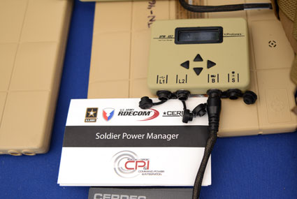
The Soldier Power Manager sits on top of a conformal battery. Allowing multiple devices to be connected to a battery, it reports battery usage, power remaining, and power usage by connected devices. (Photo: U.S. Army/C. Todd Lopez)
David also had with him a device he called the Soldier Power Manager. The power manager was connected to a “conformal battery,” which was also developed at CERDEC in conjunction with industry. The conformal battery is flexible and slips easily into a soldier’s tactical vest without being uncomfortable due to stiffness. It wraps around a soldier’s torso.
The power manager allows multiple devices to connect to a battery, and provides a display saying how much power is left in the battery, what devices are connected to the battery, and how much power each device is using.
“It lets you know how much energy is left and what is plugged in,” David said. He said one advancement the lab has made on the system is to transfer the user interface to a Nett Warrior device, so soldiers can see it on that screen.
“It lets you see the total power left on the device and how much energy each device is pulling, so you can make a decision about what device to pull — when energy gets low — to make sure you have enough power to meet mission needs. We have sort of integrated the energy component with the information to make better choices in the battlefield in terms of operational energy.”
GPS World will host a webinar this Thursday, March 19, on the merits of using simulated jamming, spoofing and interference scenarios to prepare GNSS receivers for the brave new world of coping with adverse signal effects. It’s clear that users need to still operate commercially and individually, even when they get hit by extraneous interference — intended or otherwise — in a world where cigarette-lighter jammers, engineering “lash-up” spoofers, and badly designed commercial gear can ruin a person’s day.
Recently, I had a conversation with Guy Buesnel, market segment manager, GNSS Vulnerabilities, at Spirent Communications. He wanted to alert me to the concept that jamming and spoofing is at a stage where Internet hacking was many years ago. Hacking has progressed from the typical loan student in his bedsit or studio apartment pounding on a keyboard to break down banking or other institutional firewalls, to nowadays, where focused groups mount hacking attacks on targeted agencies or companies lasting days, weeks, even months. Huge effort is currently being applied to defending against these and future focused attacks.
Buesnel’s point is that organized attacks on GNSS may be coming, and coming soon. Individuals and groups are already self-jamming to prevent detection — organized car and truck thieves wanting to avoid location of stolen assets, or truck drivers wanting to prevent their employers knowing their whereabouts — using easily obtained “personal cigarette lighter” or even professional-looking jammers (see figure below). Jamming GPS L3 at 1381.05MHz might awaken U.S. Department of Defense (DOD) interest as it’s used by the Nuclear Detonation (NUDET) Detection System Payload (NDS), and L4 at 1379.913 MHz is currently only used for studies on additional ionospheric corrections.
But Buesnel warns that organized spoofing could soon start to happen, and happen frequently. And it could be argued that spoofing is more dangerous than jamming, because a user or someone monitoring a user might not know for some time that their position information has been compromised. Long enough, perhaps, for an unwary user to get into potentially serious trouble, especially in a higher speed, fuel-restricted application like an aircraft or a small boat running some distance offshore.
GNSS is already embedded into the critical infrastructure of utility providers, and also telecoms, financial and transport sectors for timing/synchronization or positional data, and the growth in vehicle automation will soon see GNSS being used for even more safety-critical applications. The security of GNSS is already of huge importance and a “GNSS hacking attack,” like those experienced by Internet users, could achieve significant disruption across a host of operational segments. Precise GNSS timing is already essential for time stamping some transactions and used extensively for cell-site synchronization, so significant damage could occur if timing information were to be compromised.
While an intentional spoofing attack has yet to be confirmed — except under conditions such as that drone spoofing demonstration and then the White Rose luxury yacht spoofing trials, both by University of Texas/Cockrell School of Engineering graduate students — unintentional spoofing has indeed been reported. GNSS repeaters radiating at higher power levels than actual GNSS signals can be the source of such spurious signals. The result can be that GNSS receivers may acquire and track the higher power repeater signals, and the receiver position becomes that of the repeater. Use of GPS repeaters in unsuitable locations, such as for production tests in an open workshop, have been reported. The risk is that GNSS signals could extend outside the building and affect users, so GPS receivers could be spoofed and tricked into reporting an incorrect position.
White Rose 213-foot luxury yacht. Photo: Tony Murfin
For more than 20 years, the information security community has debated publishing the methods used by hackers and others to expose and attack vulnerabilities within products. Initially, things were kept hidden and were only shared between groups of hackers or IT administrators. However, online hacker forums quickly distributed knowledge — often including sample code. This allowed everyone from security researchers and IT administrators to hackers to learn about the vulnerabilities of applications and critical systems. It would seem that both researchers and hackers alike have broken the spell, and now it’s easy to spread the word about backdoors and weaknesses in firewalls, critical applications and the like.
Fast forward, and we are now in the age of mass-market access to jammers of all kinds through offshore websites — even if it’s illegal to operate such devices. However, it’s also illegal to hack the Department of Defense, but that has not prevented hackers in the past from assaulting and penetrating all sorts of secure DoD computing facilities. So, let’s just assume that the individuals who get a kick out of creating mayhem may eventually turn to something new — and the age of jamming and spoofing for fun may be upon us.
All is not lost, however. Just as applications for finding and killing viruses have become more robust, and new “antidotes” and warnings are now automatically downloaded to your PC even as they are created, and huge amounts of effort are now being applied to creating the most robust firewalls, so the designers of GNSS receivers are working hard to immunize their systems against anticipated attacks. And simulator/replay manufacturers such as Spirent Communications, IFEN, Spectracom and Racelogic are developing and fielding ready-made spoofing and jamming capabilities and scenarios with which manufacturers can test and qualify their receivers — which you may well hear about during the coming GPS World webinar on March 19.
Nevertheless, some people in the industry are urging members of the GNSS community to act more cooperatively and report spoofing and jamming incidents/attacks for their own good. It seems that the industry only collaborates in the face of a major common threat — take the ultra wideband and LightSquared episodes where the response was virtually unanimous. While most GNSS manufacturers in the meantime tend to maintain a very proprietary cover to their field experience and technological solutions, this still leaves customers exposed to product vulnerabilities. The GNSS community now has the advantage that the information security community has been working through these hurdles for the past two decades. Lessons learned include the following:
Controlled, responsible disclosure and cooperation allows everyone to monitor the threat and how it is being dealt with.
Without restricted disclosure and preventive solutions, attacks will always take advantage of weaknesses.
Eventually, disclosure of product vulnerabilities will result in more respect and confidence in manufacturers by users.
Rapid resolution of issues is essential.
The GNSS community has an opportunity to come together, learn from the information security community, and adopt best practices to secure and protect its customers.
(With grateful thanks to Guy Buesnel and David DeSanto of Spirent Communications!)
The Lockheed Martin GPS III Non-Flight Satellite Testbed (GNST).
A Lockheed Martin vice president has stated that the first GPS III satellite will likely launch in 2017, not 2016 as had been projected in the most recent update.
The company is readying the first satellite for launch availability by the end of 2015, for launch as early as the end of this year, but Space News reports that Mark Valerio, vice president and general manager of Lockheed Martin’s military space business, stated in a Feb. 18 news briefing that he expects the Air Force will schedule its launch for early 2017.
The GPS III generation of modernized satellites — with new signals, added signal strength, and resistance to interference and jamming — was originally projected to begin orbiting in 2014. Technical difficulties have delayed the program. The principal issues, those with the payload, have now been resolved, according to Valerio.
Valerio expects a firmer GPS III launch announcement for 2017 in March. He expected the final launch date “will depend on the health of the existing constellation, the availability of launch slots and synchronization with the ground system.” Ultimately, the Air Force always makes the final decision on the launch date.
Lockheed Martin is contracted to build eight GPS III satellites.
Late last year, a spokesman for the Space and Missile Systems Center said that “The first GPS III launch is tentatively considered for the first half of FY17, based on booster availability and Air Force launch priorities.”
The Air Force has put out feelers for other contractors to finish out the full generation of GPS III satellites. Lockheed Martin is building eight, with an option for four more, totalling 12; a complete constellation of III-generation satellites would require 24. Boeing Space and Intelligence Systems and Northrop Grumman Aerospace are reportedly interested.
“The best thing I can do is keep marching along the plan we have,” Valerio said. “We’re certainly not afraid of the competition.” Lockheed Martin has submitted cost-cutting proposals for the current GPS III satellite design, he added.
Ground Control
The corresponding new ground system for GPS III, the Operational Control Segment (OCX), has also fallen behind schedule. Just this month, the Air Force announced that Lockheed Martin may develop an interim control capability, a set of changes implemented upon the current control segment, the Architecture Evolution Plan (AEP), as a backup.
Michael Gilmore, the Defense Department’s director of operational test and evaluation, recently stated that OCX delays have pushed back GPS III operational testing “until after at least six, and as many as eight,” satellites have been launched into orbit. “This introduces significant risk that effectiveness and suitability deficiencies in GPS III satellites will not be discovered until it is too late to prevent their introduction to the operational constellation.”
Budget Blues
Don Jewell, GPS World’s contributing editor for defense, has written at length about the GPS III and OCX situations in his February newsletter column, “USAF FY16 Budget Plus $10B More, Please!”. We condensed some of his remarks, particular to the budget battle on Capitol Hill, for the Out in Front column of the March issue of the magazine, due out soon. Here is a further digest of those comments.
The 2016 President’s Budget, submitted in February, contains an Air Force requested a budget of $122.2 billion. This may be too little, too late.
On the satellite side of the house, GPS III has problems centering on development and delivery issues with a subcontractor. In this case, however, the whole satellite program is not failing, just a component, albeit an important one: the Mission Data Unit (MDU).
For GPS III+, the Air Force plans for a two-phased competition process: a Production Readiness competition for up to three firm-fixed price contracts to mature competitors’ production designs for a competition in a full and open competition for up to 22 GPS III Production SVs [satellite vehicles] with an expected award in FY17/18.
This sounds great if you need an entirely new GPS III system, which consists of, at a minimum, a new payload, satellite, launcher and ground C2 system. In fact, the government only needs an MDU. Failure to produce the MDU on time has delayed GPS III by 18 months to date.
More troubling are the government proposals to entertain other bids to finish the second half of the GPS III constellation. Such a competition or re-bid will take at least three years and cost hundreds of millions of dollars — and Lockheed Martin may well win again in the end
A significant added cost to the GPS budget concerns the need for a new ground C2 system if the total new systems approach is taken. If preliminary elements of the GPS space segment are developed without cross-checking the impact to the GPS control segment, technical, operational, budgetary and schedule impacts will be significant.
The already perturbed OCX budget likely has not considered the integration costs of a newly developed, yet-to-be-procured GPS III+ SV. OCX today is geared for the GPS III already contracted for, and it is failing to meet that challenge.
Budget constraints are tight and getting tighter, mandating the Air Force “do more with less” in every context. For GPS III SVs, this should — but by no means necessarily does — indicate developing an alternate MDU rather than buying a new block of GPS SVs.
Lockheed Martin and Esri have deployed commercial software to the Amazon Web Services Commercial Cloud Services (C2S) environment for the first time with an intelligence community customer, the National Geospatial-Intelligence Agency (NGA). The move enables government agencies to better share geospatial intelligence.
The deployment of the portal for Esri’s ArcGIS geographic information system (GIS) provides a single environment for analysts to securely organize and share data throughout the intelligence community and Department of Defense. It’s also the foundational step in consolidating multiple geospatial intelligence portals into the single NGA-provided portal, resulting in technology and license cost savings.
This is NGA’s second pioneering step in the cloud, after the agency moved its Map of the World application to the C2S environment late last year.
“Deploying Esri’s Portal for ArcGIS to a commercial cloud environment securely organizes existing data and facilitates collaboration across intelligence agencies,” said Jason O’Connor, vice president of Analysis and Mission Solutions for Lockheed Martin. “This cloud implementation also further shapes the government’s processes for architecting and implementing enterprise class services within a cloud environment.”
ArcGIS connects users to maps and geographic information. Users can create and view maps, compile geographic data, analyze mapped information and share geographic information in a range of applications.
“Working with Lockheed Martin and the NGA on this strategic implementation for national security is particularly meaningful,” said Jack Dangermond, Esri president. “It recognizes the importance of consolidating geospatial intelligence information into a single portal to facilitate rapid situational awareness and response by our intelligence community.”
Lockheed Martin and Esri have partnered for eight years on the Geospatial-Intelligence Visualization Services (GVS) program, which helped NGA and the Intelligence Community achieve this cloud migration milestone. The Total Application Services for Enterprise Requirements (TASER) GVS contract vehicle, which was originally awarded in 2012, conveys geospatial visualization context and analytic capabilities to warfighters, intelligence officers and policy-makers through classified and unclassified computer networks.
The long-anticipated 2016 President’s Budget (PB) was submitted to Congress in early February. The PB is the spark that ignites the lengthy and often contentious congressional budget process, including: adopting a budget resolution framework, developing numerous discretionary spending bills, reconciling legislation between the House and Senate, approving continuing resolution stop-gap measures and finally, hopefully, appropriating funds for various programs — including the Global Positioning System (GPS) as part of the Department of Defense’s (DoD’s) U.S. Air Force (USAF) budget request.
For FY (Fiscal Year 1 Oct – 30 Sep) 2016, the U.S. Air Force requested a topline budget of $122.2 billion in Air Force controlled funding that exceeds funding levels recommended by the OMB (Office of Management and Budget) and laid out in the Budget Control Act by almost $10 billion. Several well-meaning friends still in high places in the government immediately sent me copies of the USAF budget while it was still warm, so to speak, and thought that I would be “properly incensed” — proffered one old friend — over the so-called $10B overdraft. I hate to disappoint my friends, but in the spirit of the USAF policy of putting the Bottom Line Up Front, I applaud the Air Force action and personally think it may be too little, too late. The supplemental request or overdraft should probably have been more on the order of $20B, not $10B.
Hollow Force
This is not an emotional reaction, but a reasoned statement by a seasoned veteran airman of 30 years in the USAF, yours truly, who served through at least two periods of a “hollow force” that were devastating not only to the USAF as an institution, but to the DoD as a whole and to all the personnel who served during these austere and dangerous times. And, yes, I am equating a hollow force with a dangerous force. Indeed, the term “hollow force” officially refers to military and government forces that certainly, on the surface, appear to be “mission ready,” but upon close examination suffer from moderate to severe shortages of personnel and equipment as well as deficiencies, to varying degrees, in training.
Gen Mark A Welsh III, Chief of Staff, USAF, testifying before the Senate Armed Services Committee 201 (Photo courtesy of USAF – SSG Sean K. Harp).
In recent testimony before the Senate Armed Services Committee, along with his fellow service chiefs, General Mark A. Welsh III, chief of staff of the United States Air Force, laid out the dangers inherent in the hollow force when he stated:
“Last year, our readiness levels reached an all-time low. As we struggle to recover, we don’t have enough units ready to respond immediately to a major contingency, and we’re not always able to provide fully mission-ready units to meet our combatant commanders’ routine rotational requirements.
“The Air Force’s modernization forecasts also are bleak. About 20 percent of [our] aircraft flying today were built in the 1950s and 1960s, and more than half of the rest are 25 years old or older.
“And now, due to sequestration, we’ve cut about 50 percent of our currently planned modernization programs.”
To someone who lived through the hollow force in the past, this is a scary description and prospect for our airmen. In describing the results of budget cuts and difficult decisions regarding program terminations that result in a hollow force, General Welsh put it this way:
“Without these tough calls, the Air Force ‘will be neither ready to fight today, nor viable against the threats of tomorrow’.”
Indeed, a hollow force puts every ones lives in danger. During the post-Vietnam hollow force created by the peanut farmer, there were times when there were B52 aircraft sitting alert just for the spy satellite photo ops that did not have engines in the nacelles nor certified crews to fly them. Aircrews were lucky if they were able to fly four hours per month, and believe me, that made us all less than proficient. I remember one incident specifically. My oxygen (O2) mask had failed on a previous flight and I needed a new one. In the high-performance aircraft in which we flew, regulations required an O2 mask be attached to our helmet and actually in place with crewmembers in the cockpit breathing pure (100%) O2 above a certain altitude. Because of budget cuts, I was issued a waiver, a piece of paper that said I was legal to fly without a fully functioning O2 mask. Fortunately I never was forced to fly without a fully functioning O2 mask, but what if I had been? What if I had passed out from O2 deprivation? What about the other members of the crew? What purpose did the piece of paper serve, other than mollifying a paper pusher’s conscience? Would the Air Force crash investigators have found it in the wreckage and said, “Oh, it’s OK, he had a waiver!” These are the types of things that can happen with a “hollow force.” We don’t need to go there again, and if nothing else, the extra $10B may be just the ticket to keep the aircrews proficient and equipment maintained.
The Color of Money
I know that budgeting and spending other people’s money seems like a simple issue, but with the government, nothing is ever simple. Consequently, the DoD has established an entire university system, known as the Defense Acquisition University (DAU), to train acquisition, program and financial officials in handling government acquisition funds, along with other procurement activities. Under the Budget Control Act guidelines and the Congressional cost-cutting exercise known as Seques-castration, 2016 is another cost-cutting year. That is significant when you understand that the USAF and all of DoD are still reeling from more than ten years of war, on more than one front, along with previously mandated significant budget and manpower cuts that seriously impacted the ability of the USAF to accomplish its multitude of missions.
Consider that budget cuts have a lingering, insidious and costly effect in equipment not maintained or replaced, training not accomplished, R&D not conducted, new technologies not developed, and inevitably the inability to accomplish the mission. A lot of the complexity in these budget-cutting moves relates to what the government refers to as the color of money. For example budgetary funds are appropriated and obligated for the USAF, and most other services, according to the following formula:
O&M – Operations and Maintenance – Obligated for 1 year
MILPERS – Military Personnel – Obligated for 1 year
RDT&E – Res Dev Test & Eval – Obligated for 2 years
PROC – Procurement – Obligated for 3 years
MILCON – Military Construction – Obligated for 5 years
As you can see, all funds are not obligated for just one year and then the money expires. Indeed, there are several colors of money, and failing to fund an RDT&E effort can have catastrophic results on the future of that program and associated programs that might benefit from the technology not developed. At any one time, the USAF is juggling budgets stretching across years and programs and moving money or robbing Peter to pay Paul.
FM (Financial Management) or financial and program management gurus at any one time are managing funds that originated as many as five years previously, plus the current year’s budget, while planning on how to use funds that might carry over to next year. They have just submitted the FY16 budget, which also means they are now hard at work on the FY17 budget without knowing what will be obligated for FY16. Across all those budget years, they have to deal with the arcane rules concerning the color of money. Yes, they are professionals (I’ve been married to one of the best for 35+ years), and they do a great job, but face it — sometimes they are just taking a well-educated guess and hoping for supplemental funding just to meet basic requirements.
Seriously, FM’ers live for the fairytale that one day a combatant commander will say, “Hey, your mission is more important than mine, so I will ‘MIPR’ (a one-time financial move) my funding to your budget line for your project.” Let’s see — a pig is not aerodynamically designed to fly…
Space
Funding for all space programs is especially critical, as the entire space arena is known as a force multiplier, in that satellites and space platforms provide and enable capabilities that increase the effectiveness and reach of all military and government personnel. Therefore, when space programs are not funded, delayed or are cut, the impact ripples across the entire DOD. This is especially true of GPS and PNT (Position, Navigation and Timing) systems which have become so ubiquitous, they are considered a must-have utility for billions of users around the globe, not just the U.S. government. In fact, military and government users may be the smallest segment of users for GPS and PNT services today, which is ironic when you consider that, as General John Hyten (USAF), commander of Air Force Space Command, loves to remind us, “GPS is provided to the world, and over three billion plus users, free of charge 24/7, by the United States Air Force.”
OCX – Next-Generation Space Control Segment
Unfortunately, a couple of major GPS-related programs are in trouble. For OCX, the Next-Generation Control Segment for GPS, my sources tell me, and 2016 budget documents clearly show, that current costs attributable to the prime contractor greatly exceed the contract award specification of ~$886M by a factor of 100% ,with a delivery date still far out on the horizon — somewhere around 2020 with a total program costs of $3.6B. That’s the bad news; the good news is there are definitely sound alternatives, and my sources tell me they are being belatedly explored.
Sometimes the behemoth primes are just that: too big and too expensive. Oftentimes the real subject matter experts (SMEs) reside in the smaller, boutique, more agile companies that can do the job in 24 months for $200M, which is a price that was quoted to me recently by a company with skin in the game, since their software products are responsible for launching and controlling all of the GPS satellites launched in the last eight years without a single failure. Plus, sources inside the company tell me that they have already developed a complete launch and initial checkout system for GPS III, which the OCX prime contractor is still struggling to construct.
This is where the USAF and OSD must step back and assess the OCX program for all its merits versus costs. GPS is not that complicated a satellite system, and yet we are on course to spend $3.6B for a ground C2 (Command and Control) system that will still have significant shortcomings. If it were the perfect C2 system in the end, that would be one consideration, but in fact, as the prime has admitted, it will be far from what was initially envisioned, and the total program costs will have grown by almost 400%.
This scenario begs the question: As the GPS acquisition authority, which product would you trust, a known product derived from a proven government and commercial satellite launch and C2 capability in operation today from a reliable company that has a flawless track record of GPS launches for the last eight years? Or a brand-new unproven product costing billions of dollars from a company that is clearly struggling technically and financially and has, at the end of the day, never launched or controlled a single GPS satellite? The answer seems clear to me. Obviously, there are valid alternatives, and in this budget environment the USAF needs to take a look at replacements, alternatives, supplements and backups, however you choose to phrase it, to OCX.
As we were going to press, we learned that Mr. Kendall has given the OCX Program a green light, but with several caveats indicating the program will be closely watched in the future. Mr. Kendall confirmed that while the OCX costs had indeed doubled, he was going to stay the course for now.
Major General Roger Teague, director of space programs for the Air Force acquisition chief, said a review by chief arms buyer Frank Kendall went well, but program officials and the contractor got “tough marching orders” to stick to schedule and cost targets. That is well and good, but history shows us that it has never happened in the past with the OCX program, and so some tough changes are going to have to be made if they are going to stay on track. We wish them well.
GPS III – Next Generation Space Segment
On the satellite or hardware side of the house, the GPS III — or next-generation GPS satellite — is also having problems, but in this case it centers on development and delivery issues with a subcontractor having serious technical issues and who has failed to deliver on cost or schedule. That subcontractor was just last week bought by a bigger prime, so we will have to wait and see what happens. In this case, however, the whole satellite program is not failing just a component, albeit an important one, the Mission Data Unit or MDU. Although again the answer seems simple, there are bigger forces at play, and one of them is wrapped up in a new government initiative known as Better Buying Power 3.0.
Better Buying Power 3.0
The current GPS III+ budget input states: “In an effort to implement Better Buying Power 3.0 (BBP 3.0) to control production costs, the [U.S.] Air Force intends to create a competitive environment. Options for the GPS III competition continue to be explored by USD (AT&L) [Under Secretary of Defense for Acquisition, Technology and Logistics], Mr. Frank Kendall.
Frank Kendall, under secretary of Defense for Acquisition, Technology and Logistics; the Under Secretary flag.
The Under Secretary of Defense for Acquisition, Technology and Logistics, or USD (AT&L), is a senior civilian official in the Office of the Secretary of Defense within the Department of Defense. USD (AT&L) is the principal staff assistant and advisor to the Secretary of Defense and the Deputy Secretary of Defense for all matters concerning departmental acquisitions and the general management of the department as a whole, which means he is a significant decision-maker where DoD acquisitions are concerned, and he has something to say about the plans for those acquisitions. Obviously, those plans need to make sense, financially, operationally and hopefully logically. Mr. Kendall, who has been in his current position for almost four years, has brought a much needed common-sense approach to government acquisition, and we can only hope he continues to make judicious, practical and logical decisions.
For GPS III+, the U.S. Air Force’s published notional plan is for a two-phased competition process. Phase one is a Production Readiness competition for up to three firm-fixed price contracts to mature competitors’ production designs for a competition in Phase two. Phase two will be a full and open competition for up to 22 GPS III Production SVs [satellite vehicles] with an expected award in FY17/18. The [U.S.] Air Force GPS Directorate received USD (AT&L) approval to purchase GPS III SV09-10 from the incumbent Lockheed Martin (LMCO) at the December 2014 Defense Acquisition Board (DAB), in order to sustain the GPS constellation while competitive options are pursued.” [Bold added for emphasis.] See the budget document here.
The “government speak” sounds great if you need an entirely new GPS III system, which consists of, at a minimum, a new payload, satellite, launcher and ground C2 system (remember OCX is only designed to work with current and planned GPS SVs, and it doesn’t even do that today). But, in fact, the U.S. government only needs an MDU, which is a critical part of the payload. Indeed, failure to produce the MDU on time has delayed the entire GPS III program by about 18 months to date.
Even more troubling to me is the seemingly innocuous phrases from the government plan that states “create a competitive environment…firm-fixed price contracts to mature [up to three] competitors’ production designs,” which is nothing more than government speak for “We are going to pay competitors to mature their technology so they can compete against the current prime (LMCO), who is currently building the first 10 GPS III satellites.” In effect, the government is saying the competitors on their own cannot compete against LMCO so we, the government, are going to give them contracts and lots of money to help them get to a point where they can compete, and then we are going to have a recompetition. Of course, this is going to take at least three years and cost hundreds of millions of dollars, and LMCO may well win again in the end, but at least we will have conducted a competition. Does this approach make sense? Does it pass the financial, operational, and logic tests? Does it pass the Washington Post test? I guess we will have to wait and see if Frank Kendall agrees.
BBP 3.0
So, what exactly is the initiative known as Better Buying Power 3.0? It’s DoD’s mandate to “do more with less”:
“DoD’s Mandate To Do More Without More
“Better Buying Power (BBP) is the implementation of best practices to hopefully strengthen the Defense Department’s buying power, improve industry productivity, and provide an affordable, value-added military capability for the warfighter and government user. Launched in 2010, BBP encompasses a set of fundamental acquisition principles to achieve greater efficiencies through affordability, cost control, elimination of unproductive processes and bureaucracy, and promotion of competition. BBP initiatives also incentivize productivity and innovation in industry and Government, and improve tradecraft in the acquisition of services.”
Sounds great, doesn’t it? Now for the rest of the story.
We can all agree that defense budgets are tight, so it will be interesting to see how BBP 3.0 plays out in the arena for GPS SVs. Will the U.S. Air Force initiate a competition to acquire an entirely new GPS III SV, or fix the problem with the current GPS III program, the MDU? Recall my previous column concerning the GPS III Sources Sought, in which the GPS III MDU was compared to an aircraft engine and the GPS III satellite was compared to an aircraft. In this analogy, the Air Force didn’t ask for companies/competitors to produce a new aircraft just because it needed an alternate engine. It simply contracted for another engine supplier — the most cost-effective competition that adheres to the principles of BBP 3.0. However, from the GPS Directorate budget language quoted earlier, it appears as if the Air Force is looking to pursue an entirely new GPS III system to include SVs, rather than just procure an alternate MDU.
In my humble opinion, stringently applying BBP 3.0 to GPS III issues means simply to employ competition at the correct level (i.e., for the engine rather than the entire aircraft). An interesting feature and significant added cost to the GPS budget, which I briefly mentioned earlier, concerns the need for a new ground C2 system if the total new systems approach is taken. For, indeed, if preliminary elements of the GPS space segment are developed without cross-checking the impact to the GPS control segment, the technical, operational, budgetary and schedule impacts will be significant. For example, the already troubled next-generation GPS ground control system, OCX, budget likely has not considered the integration costs of a newly developed, yet-to-be-procured “production ready” GPS III+ SV. Indeed, OCX today is geared for the GPS III already contracted for and it is failing to meet that challenge in a spectacular and expensive way. So it is possible, even probable, that OCX integration costs for yet another new model of GPS III family of satellites would increase the OCX budget significantly…unless of course one assumes that the U.S. Air Force acquires a perfectly matched, new GPS III satellite that integrates seamlessly with OCX. In other words, an entirely new GPS III SV would need to be perfectly matched to the current GPS III SV — and what are the chances of that, and why would you spend hundreds of millions of scarce acquisition dollars to procure an exact and more expensive replica?
Budget constraints are tight and getting tighter. BBP 3.0 mandates the Air Force “do more with less” in every context. For GPS III SVs, this means developing an alternate MDU rather than buying a new block of GPS SVs.
Until next time, Happy Navigating, and remember: GPS is brought to you free of charge by the United States Air Force.
“This message outlines the risks associated with the use of Web Mercator applications for DoD and GEOINT user community operations. The NGA Geomatics Office has assessed the use of Web Mercator and other non-WGS 84 spatial reference systems may cause geo-location / geo-coordinate errors up to 40,000 meters. This erroneous geospatial positioning information poses an unacceptable risk to global safety of navigation activities, and Department of Defense, intelligence community, and allied partner systems, missions, and operations that require accurate and precise positioning and navigation information. The NGA Geomatics Office reminds the community to use DoD approved World Geodetic System 1984 (WGS 84) applications for all mission critical activities.”
Many popular commercial visualization, mapping and mobile web device applications use a Web Mercator spherical earth reference. “These applications are not an equal alternative to DoD WGS 84, as they do not provide the same geo-coordinates or geo-location accuracies,” the advisory states.
The Department of Defense announced that U.S. Air Force Space Command will begin broadcasting Civil Navigation (CNAV) messages on all operational GPS satellites capable of transmitting the L2C and L5 signals. L2C and L5 are the first of several new civil capabilities being added to GPS as part of the GPS modernization program announced in 1999. The L2C signal is designed to meet commercial needs and L5 meets safety-of-life transportation requirements.
“We have been working in partnership with the U.S. Department of Transportation (USDOT) to enable early delivery of two more civilian frequencies from the GPS satellite constellation,” said Maj. Gen. Robert E. Wheeler, DoD deputy chief information officer, C4 and Information Infrastructure Capabilities. “These new CNAV messages will enable manufacturers to develop and test advanced civil receivers and make for a more robust Position, Navigation and Timing (PNT) solution available to the civilian public. We do not anticipate any GPS satellite outages or legacy degradations as a result of the pre-operational deployment of these frequencies, and those currently using the GPS Standard Positioning Service should not be impacted,” he added.
The implementation will take place in two phases. First, on April 28, 2014, the initial broadcast of CNAV message-populated L2C and L5 signals will occur at a reduced data accuracy and update frequency compared to the legacy GPS signals in wide use today. Second, in December 2014, CNAV data updates will increase to a daily rate, bringing L2C and L5 signal-in-space accuracy on par with the legacy signals. However, derived position accuracy cannot be guaranteed during the pre-operational deployment of the frequencies. These pre-operational signals are primarily used to test various equipment and should be employed at the users’ own risk; not used for safety-of-life or other critical purposes.
The Air Force will broadcast L2C messages with the health bit set “healthy,” as was the case during a June 2013 test. L5 messages will be set “unhealthy,” but as greater experience with the L5 broadcast and implementation of signal monitoring is achieved, this status may change upon review. The public will receive ample notification before any decision to set the L5 health bit to “healthy.”
“The U.S. Department of Transportation is pleased with the collaborative effort and work of the CNAV tiger team, formed between the Office of the Secretary of Defense, Air Force Space Command, and the U.S. Department of Transportation, to address concerns about implementation of a pre-operational CNAV capability on the GPS L2C and L5 signals,” said Greg Winfree, assistant secretary for research and technology at USDOT.
For additional information about the testing, contact the Air Force Space Command public affairs office at 719-554-3731.