Spectrum regulation is much like land-use zoning: certain services are kept separate to avoid disturbing the neighbors. The U.S. Federal Communications Commission (FCC) has in effect allowed Ligado to build an outdoor concert venue next to a monastery, and by way of compensation, they offer free earplugs.
GPS/GNSS signals are extremely weak and the receivers are extremely sensitive. To give some perspective, by the time they get to the GPS receiver, GPS signals are about a factor of 20 less powerful than cosmic background noise. Ligado’s spectrum was licensed for mobile satellite services (MSS) and so was not likely to interfere with GPS.
“The U.S. Federal Communications Commission (FCC) has in effect allowed Ligado to build an outdoor concert venue next to a monastery, and by way of compensation, they offer free earplugs.”
With its new, and much more valuable license, Ligado now has a legal right to build a terrestrial cellular service. Exhaustive testing over the past 10 years has repeatedly demonstrated that such a system will interfere with high-precision GPS/GNSS receivers used in surveying, timing and Earth observation. The Department of Defense (DOD) has also made strong claims that such a system will cause harm to its systems. In all cases, the effect is much like riding a bicycle at night. You can see fine until someone comes around the corner with the high beams on and blinds you.
In its earlier filings, Ligado had asked for permission to transmit at a power level of 1500 Watts. In an amazing piece of legerdemain, they convinced the FCC, but not the Department of Transportation (DOT) or DOD, that by reducing transmit powers to 10 Watts, there would be no harm. This is a stunningly erroneous claim. As you lower the transmit power, you need many more cellular base stations to cover a given area. To use an analogy from my backyard, I can install one high-flow sprinkler head to cover the entire yard or a bunch of low-flow heads, each covering a small portion. Either way, the grass doesn’t care about anything other than inches of water, and I’m going to get wet if I run across the yard. Ligado’s core argument is equally wet. Nonetheless, it has great appeal to people who don’t understand how cellular systems work.
So, moving forward and assuming the license stands, interference events will become more prevalent and GPS will be deemed “less reliable.” Because interference sources are largely untraceable, blame will rarely attach to Ligado. I expect that GNSS receiver vendors will incorporate improved filters into receivers and pass the cost along to buyers. Ligado, or more likely whoever it sells the spectrum to, will quickly move to petition for increased transmit powers to lower capital costs; after all, more base stations cost more. And so, the Visigoths have arrived, 4G in hand with a 5G label.
Logan Scott is founder and owner of Logan Scott Consulting, www.gpsexpert.net.
The USGIF Awards Program annually recognizes the exceptional work of the geospatial intelligence (GEOINT) tradecraft’s brightest minds and organizations pushing the community forward.
Award winners are usually recognized at the annual GEOINT Symposium. This year’s event, scheduled for April 26-29 in Tampa, Florida, was canceled because of the COVID-19 pandemic.
“Unfortunately, you will not see the awardees recognized on the GEOINT Symposium stage this year,” said Kevin Jackson, chair of the USGIF Awards Subcommittee. “So please take a moment to read their accomplishments and join me and the USGIF in congratulating the 2020 USGIF Achievement Awardees and the runners-up.”
Award winners are nominated by their colleagues and selected by the USGIF Awards Subcommittee.
“The 2020 USGIF awardees reflect the importance and the significance of the outstanding work that occurs daily in the GEOINT community,” Jackson said. “You will see how the GEOINT community always rises to the occasion to face head on the world’s toughest problems and this year is no exception.”
Academic
James Martin Center for Nonproliferation Studies, Middlebury Institute
On Dec. 7, 2019, after denuclearization negotiations between the United States and North Korea collapsed, North Korea reversed commitments made in Singapore and resumed engine testing at its Sohae Satellite Launch Center. Using new technological opportunities offered by high-cadence moderate resolution satellite imagery and flexible high-resolution satellite image tasking provided by Planet Labs, analysts at the CNS, through the use of open-source GEOINT, detected and correctly identified preparations for the engine test 39 hours before it occurred. Announcing in advance that North Korea was preparing to violate an international nonproliferation commitment.
Community Support
NGA Expeditionary Operations Office
NGA’s Office of Expeditionary Operations provides deployed personnel and technology to support GEOINT activities of worldwide U.S. military operations, humanitarian assistance and disaster relief efforts, and other national security objectives. The team’s world-class workforce seamlessly enables trusted global GEOINT capabilities today, while developing programs and processes to meet emerging challenges. Robust partnerships with DoD and IC allies fuel innovation and expertise, helping U.S. and foreign partners build programs that anticipate their needs, expanding the GEOINT community and optimizing meaningful consequence across the GEOINT enterprise.
Government
Mark A. Skoog and Loyd R. Hook
Implementing digital terrain solutions for safer aviation has been a career-long goal for Mark Skoog and Loyd Hook. As true innovators and lifelong proponents of using digital terrain data, Skoog and Hook lead the development efforts of NASA’s award-winning Automatic Ground Collision Avoidance System (Auto GCAS), which prevents imminent collisions with the ground. Auto GCAS is the culmination of a decades-long effort to bring geospatial intelligence to aircraft safety. This work involved traveling the world, evaluating myriad digital terrain from Sweden to Hawaii. The team extensively tested the system to ensure against every category of controlled flight into terrain mishaps—and found it would have prevented every one, which resulted in ten lives saved thus far in the USAF operations.
Industry
Lockheed Martin Space GATR Team
Globally-scalable Automated Target Recognition (GATR) is an artificial intelligence system that finds objects of interest in satellite imagery on a worldwide basis. It was developed by a team of scientists and engineers from Lockheed Martin Space who combined state-of-the-art deep learning algorithms with scalable high-performance computing in a cloud-based framework to achieve high-speed global automated target recognition (ATR). Unlike other ATR systems, GATR searches extremely large geographic regions with accuracy and speed. The GATR team, led by Dr. Mark Pritt, includes Tyler Bartelmo, Gary Chern, Dr. Austen Groener, Michael Harner, Andy Lam, Stephen O’Neill, Ryan Soldin, and Steve Wozniak.
Military
RS/GIS CX, The GRiD Team
David Finnegan and the Geospatial Repository & Data Management System (GRiD) program provide the Department of Defense (DoD), intelligence community and geospatial community with a centralized repository for the storage, discovery, and dissemination of critical terrain and 3D data. Prior to the GRiD program, the National System for Geospatial Intelligence (NSG) lacked a centralized mechanism for the storage and discovery of this essential content. Historically, the data was subject to local storage, limiting visibility and resulting in retasking collection assets for previously characterized areas, putting military personnel and equipment at risk. By partnering with the National Geospatial-Intelligence Agency (NGA) and the DoD, the GRiD program is now the community standard and enterprise solution for 3D/elevation data discovery across the NSG.
USGIF, the United States Geospatial Intelligence Foundation, is dedicated to bringing together the many disciplines involved in GEOINT to exchange ideas, share best practices and promote the education and importance of a national geospatial intelligence agenda. For more on the awards program, visit the USGIF website.
Leaders in the GNSS/PNT community are reacting to the Federal Communications Commission (FCC) decision to approve an order to allow Ligado Networks to deploy a low-power nationwide 5G network. The departments of Defense and Transportation have criticized the decision, concerned about interference with GPS signals.
Below are statements we have received from our readers.
Logan Scott, LS Consulting
Logan Scott
Spectrum regulation is much like land use zoning in that certain services are kept separate so as to avoid disturbing the neighbors. The FCC has in effect allowed Ligado to build an outdoor concert venue next to a monastery and by way of compensation, they offer free earplugs. GPS / GNSS signals are extremely weak and the receivers are extremely sensitive. To give some perspective, by the time they get to the GPS receiver, GPS signals are about a factor of 20 less powerful than cosmic background noise. Ligado’s spectrum is/was licensed for mobile satellite services (MSS) and so was not likely to interfere with GPS.
With their new, and much more valuable license, Ligado now has a legal right to build a terrestrial cellular service. Exhaustive testing over the last 10 years has repeatedly demonstrated that such a system will interfere with high precision GPS/GNSS receivers used in surveying, timing, and earth observation. The DoD has also made strong claims that such a system will cause harm to their systems. In all cases, the effect is much like riding a bicycle at night. You can see fine until someone comes around the corner with the high beams on and blinds you.
The FCC has in effect allowed Ligado to build an outdoor concert venue next to a monastery and by way of compensation, they offer free earplugs.
In their earlier filings, Ligado had asked for permission to transmit at a power level of 1500 Watts. In an amazing piece of legerdemain, they convinced the FCC, but not the DoT or DoD, that by reducing transmit powers to 10 Watts, there would be no harm. This is a stunningly erroneous claim. As you lower the transmit power, you need many more cellular basestations to cover a given area. To use an analogy from my backyard, I can install one high flow sprinkler head to cover the entire yard or a bunch of low flow heads, each covering a small portion. Either way, the grass doesn’t care about anything other than inches of water and I’m gonna get wet if I run across the yard. Ligado’s core argument is equally wet. Nonetheless, it has great appeal to people who don’t understand how cellular systems work.
So, moving forward and assuming the license stands, interference events will become more prevalent and GPS will be deemed “less reliable”. Because interference sources are largely untraceable, blame will rarely attach to Ligado. I expect that GNSS receiver vendors will incorporate improved filters into receivers and pass the cost along to buyers. Ligado, or more likely whoever they sell the spectrum to, will quickly move to petition for increase transmit powers so as to lower capital costs; after all more basestations cost more. And so, the Visogoths have arrived, 4G in hand with a 5G label.
John Fischer, Orolia
John Fisher. (Photo: Orolia)
At Orolia, we support the position of the DOT, DHS and DOD and the measures they are taking to protect the GNSS band. However, interference is a fact of life in this band as the GNSS signals are very weak, so additional measures must be taken for resiliency, especially for critical infrastructure. Adversarial interference is much worse than this, so a range of solutions are possible: from the simple – for example, a horizon blocking antenna that shields energy from a nearby tower – to full multi-layer defenses that include RF filtering, advanced DSP filtering/detection, alternative PNT from STL signals, atomic clock and IMU backup, and CRPA antennas. No one solution covers every case, but the problem can be managed.
Mitch Narins, Strategic Synergies
Mitch Narins
It is quite concerning when a panel of lawyers makes a decision, despite the results of years and years of studies, and over the objections of our nation’s technical and operational Position, Navigation and Timing (PNT) experts. While I have championed the need for a complementary and resilient PNT system for many, many years, one cannot dispute the worldwide benefits that GPS and other GNSS have brought — from safety, security, and economic perspectives.
As noted in the FCC’s press release, “The order also requires Ligado to protect adjacent band incumbents by reporting its base station locations and technical operating parameters to potentially affected government and industry stakeholders prior to commencing operations, continuously monitoring the transmit power of its base station sites, and complying with procedures and actions for responding to credible reports of interference, including rapid shutdown of operations where warranted.” I believe that it is imperative that GPS users, both within the Government and in the private sector, understand:
How base station location information will be disseminated, what power levels and radiation patterns will be utilized, and what recourse GPS users will have to object to the proposed location and service;
How the service will be monitored for each base station location, what systems will be used to do the monitoring, and how the monitoring information will be publicly disseminated;
How reports of interference will be filed, how and by whom they will be determined to be “credible”, how and in what timeframe will a “rapid shutdown of operations” be accomplished, and how appropriate mitigations will be identified and implemented; and
Given the importance and concern associated with this action, what special oversight mechanisms, involving civilian and military participants, should be put in place to avert potential safety, security, and economic impacts to our nation’s critical infrastructure.
While one can model, and even test problems based on the location of facilities where aircraft would be expected to be operating close to the ground (e.g., airports and heliports), one can never be sure where a medevac or other first responder helicopter may have to set down in response to an accident or incident site. In keeping with the FCC’s own press release, it is unclear how a pilot experiencing problems with GPS (if, in fact the pilot could recognize such a problem) would be able to report the issue and have it mitigated in real time to support a safety or security mission — unless all areas around all ground transmitters were mapped and first responders could request specific ones to be turned off when operations were expected in a known area. Unfortunately, the limits of these operating areas are, many times, unknown or rapidly changing (e.g., forest fires) and any delay in reaction to unforeseen events could prove detrimental to safety, security, and economic wellbeing.
Mitre conducted a test wherein small Unmanned Aerial Systems (sUAS) could detect and avoid an aircraft based on receipt of its ADS-B squits. Perhaps these ground transmitters should include ADS-B receivers and automatically go off-air if a helicopter comes within a certain distance. I have no doubt that Ligado would not appreciate this solution …
I would hope that those who disagree with this decision will seek out a means to correct this through either the legislative or judicial branches or both. Personally, I cannot see how this either “promotes the general welfare” or “provides for the common defense” (I didn’t have to go to law school to come to those conclusions). I also believe that (1) the ever growing importance and criticality of PNT services should provoke the Congress to modify the makeup of the FCC to include PNT expertise at the very top; and (2) the FCC Office of Chief Engineer needs to become an independent point of expertise akin to the Office of Inspector General to preclude undue pressure and potential political “bending” of technical analyses.
Finally, regardless of whether one agrees or disagrees with the FCC’s order, no one can possibly believe that this decade-long tale of woe is an example of governmental “best practice.” As it took the energy and significant resources from so many more important PNT initiatives, I hope that a quality/leadership body (perhaps GAO and/or a group of IGs) take up the task to do an independent “lessons learned” assessment of this decade-long tale of woe needs to be carefully examined, as it took the energy and significant resources from so many more important PNT initiatives — we should never have to go through this ever again.
Mitch Narins is the principal consultant and owner of Strategic Synergies, LLC, a technical and management consulting firm that he formed after retiring following over four decades of U.S. government service with the FCC, US Navy/Marine Corps, and the Federal Aviation Administration.
Alison Brown
Allison Brown
GPS user equipment needs to be designed to be more resilient to interference. The threat to GPS has been well understood for many years but agencies and vendors have been slow to respond to improve national resiliency against jamming threats. The President signed into law the National GPS Timing Resilience and Security Act in 2018 and on 2/12/2020 signed an Executive Order on Strengthening National Resilience through Responsible Use of Positioning, Navigation, and Timing Services recognizing “the disruption or manipulation of these services has the potential to adversely affect the national and economic security of the United States.” The onus is now on vendors and agencies to develop resilient solutions that can operate in the presence of intentional and unintentional interference. These solutions would also mitigate any potential impact from the use of adjacent bands by operators such as Ligado to deploy 5G and Internet of Things services.
Ellen Hall
Ellen Hall
Overall, the GPS industry should be encouraged to do more to protect themselves from harmful interference. While it is too late for today’s receivers, the next generation needs to introduce more resilience. I agree with the House Armed Services Committee Chairman in saying, “While I strongly support development of the world’s most robust, safe and secure network, using L-band spectrum in such close proximity to critical GPS, as Ligado’s proposal requires, carries an unacceptable risk….”
The FCC said the approval order included stringent conditions aimed at ensuring that GPS would be vulnerable to harmful interference. It seems the only way to prevent harmful interference, would be to permanently fund an oversight commission to monitor Ligado’s system. I believe only Congress can appropriate funding for this effort, therefore the FCC’s decision should be a recommendation to Congress to implement. It is not enough to leave it to a five-person committee to “encourage” that “stringent conditions” are implemented. Enforcement is crucial. Critical infrastructure should be regulated to ensure that we can cope better with “noisy neighbors.”
The five-member Federal Communications Commission (FCC) voted unanimously to approve an order to allow Ligado Networks to deploy a low-power nationwide 5G network.
The approval comes despite objections from the U.S. Defense Department (DOD), other federal agencies and major U.S. airlines, all of whom are concerned about near-band interference with GPS.
The FCC said the approval order included stringent conditions aimed at ensuring GPS would not experience harmful interference.
“After many years of consideration, it is time for the FCC to make a decision and bring this proceeding to a close,” said FCC Chairman Ajit Pai in an April 16 news release. “We have compiled an extensive record, which confirms that it is in the public interest to grant Ligado’s application while imposing stringent conditions to prevent harmful interference.”
Ligado is seeking to repurpose a swath of L-band spectrum for a 5G network focused mainly on connecting smart devices and other internet-of-things services. According to the FCC, the order will “promote more efficient and effective use of our nation’s spectrum resources and ensure that adjacent band operations, including the Global Positioning System (GPS), are protected from harmful interference.”
In response, members of both the Senate and House Armed Services Committees and other defense advocates are considering legislative action to overturn the order.
Two areas that rely heavily on the integrity of GPS signals include defense and transportation. The DOD issued a joint statement with the Department of Transportation (DOT) criticizing the FCC ruling.
“Americans rely on our Global Positioning System (GPS) each day for many things: to locate citizens in need of emergency assistance through our E-911 system, to secure our financial system, to order and receive shipments, to travel by car for work and leisure, to facilitate commercial trucking and construction work, and even to make a simple cellphone call. Our departments rely on GPS each day for all those reasons as well to coordinate tactical national security operations, launch spacecraft, track threats, and facilitate travel by air and sea. The proposed Ligado decision by the Federal Communications Commission will put all these uses of GPS at risk.”
House Armed Services Committee Chairman Adam Smith (D-Wash.) released a letter he sent to Defense Secretary Mark Esper and FCC Chairman Ajit Pai raising concerns about Ligado’s 5G network.
“While the United States must be a leader in the implementation of 5G networks, our creation of these networks must not hamper our military’s operational capacity in any way. China’s aggressive, global promotion of its 5G companies presents a considerable security challenge that must be addressed. However, Ligado’s proposal, which seeks a portion of spectrum adjacent to that used for Global Positioning Systems, poses an even larger security risk.
“The Department of Defense has been clear and direct: providing this license to Ligado would cause unacceptable operational impacts and adversely affect the military’s use of GPS. The military’s seamless use of GPS is vital to our national security. Our service members rely on GPS satellites for critical precision timing and navigation, and thousands of weapons systems are embedded with GPS signals.
“While I strongly support development of the world’s most robust, safe and secure network, using L-band spectrum in such close proximity to critical GPS, as Ligado’s proposal requires, carries an unacceptable risk that far outweighs the possibility of a 5G network.”
‘Risk of crippling’ GPS
Defense Secretary Mark Esper said via Twitter on Friday that the “Ligado proposal would needlessly imperil GPS-dependent national security capabilities. The Department continues to support domestic 5G options, but not at the risk of crippling our GPS networks. Nearly a dozen other federal agencies have joined us in opposing this proposal.”
“Although I appreciate the concerns that have been raised by certain Executive Branch agencies, it is the Commission’s duty to make an independent determination based on sound engineering. And based on the painstaking technical analysis done by our expert staff, I am convinced that the conditions outlined in this draft order would permit Ligado to move forward without causing harmful interference. For example, the draft order would authorize downlink operations at a power level that represents a greater than 99% reduction from what Ligado proposed in its 2015 application.”
Image: A-Digit/DigitalVision Vectors/Getty Images
The release also provided this background about the Ligado proposal, and the “conditions” under which the FCC decided to approve it.
In recent years, Ligado has amended its application to significantly reduce the power levels of its base stations from 32 dBW to 9.8 dBW (a reduction of 99.3%). Ligado has also committed to providing a significant (23 megahertz) guard-band using its own licensed spectrum to further separate its terrestrial base station transmissions from neighboring operations in the Radionavigation-Satellite Service allocation. As such, Ligado is now only seeking terrestrial use of the 1526-1536 MHz, 1627.5-1637.5 MHz, and 1646.5-1656.5 MHz bands. The Order is conditioned to reflect these technical requirements. It also requires Ligado to protect adjacent band incumbents by reporting its base station locations and technical operating parameters to potentially affected government and industry stakeholders prior to commencing operations, continuously monitoring the transmit power of its base station sites, and complying with procedures and actions for responding to credible reports of interference, including rapid shutdown of operations where warranted.
However, The decision “appears to ignore the well-documented views of the expert agencies charged with preserving the integrity of GPS, specifically on the critical issue of what constitutes harmful interference to users of Global Navigation Satellite Systems (GNSS),” said J. David Grossman, executive director of the GPS Innovation Alliance (GPSIA). He continued,
J. David Grossman
“GPSIA has consistently advocated for adoption of the 1-dB Standard as the only reliable mechanism that provides the predictability and certainty to ensure the continuation of the GPS success story, with the support of the Department of Defense, the Department of Transportation and numerous other federal agencies. The 1-dB Standard for radiofrequency-based services is critical for GNSS. The FCC’s press release refers to conditions placed on Ligado’s application to prevent harmful interference, and GPSIA and its members intend to carefully review the details of today’s order while continuing to vigorously advocate for promoting, protecting and enhancing GPS.”
Ligado Networks President and CEO Doug Smith issued this statement in reaction to the approval.
“Ligado thanks the Commissioners for moving promptly to approve the order regarding our applications. We greatly appreciate their unanimous support as well as the expert engineering analysis determining that a terrestrial network can be deployed in the L-band to advance our country’s economic and security interests while fully protecting GPS. Our spectrum can be very instrumental in the transition to 5G, and we look forward to utilizing satellite and terrestrial services to deploy customized private networks and deliver innovative, next-generation IoT solutions for the industrial sector.”
Positive reactions to the decision
On April 20, the FCC released a compilation of responses to the decision, all of them in support.
Attorney General Bill Barr: “I applaud FCC Chairman Pai’s proposal to make available L-band spectrum, to be used together with C-band spectrum, for deployment of advanced wireless services, including 5G. As I said in my speech at the Center for Strategic and International Studies, swift FCC action on spectrum is imperative to allow for the deployment of 5G. This is essential if we are to keep our economic and technological leadership and avoid forfeiting it to Communist China.” (Statement, 4/16/2020)
Secretary of State Mike Pompeo: “I commend Federal Communications Commission (FCC) Chairman Pai’s draft order that would release the L-Band spectrum. Quick action on this order, in conjunction with the allocation of a portion of the C-Band for 5G, is vital to our national security and will help ensure that the United States is the global leader in advanced technologies such as AI, the Internet of Things, edge computing, and the next generation of telemedicine. Accelerating the deployment of 5G is essential to our country’s growth, and global economic security.” (Statement, 4/16/2020)
Sen. Ron Johnson (WI): “In a time when connectivity is and will continue to be more important than ever, it’s great to see @AjitPaiFCC move forward with freeing up critical spectrum resources for #5G.” (Tweet, 4/16/2020)
Sen. Mark Warner (VA): “As the U.S. works to lead the world in 5G innovation and promote wider high-speed internet coverage, it’s all the more important to put our valuable mid-band spectrum to use. I urge the @FCC to follow the Chairman’s lead and approve Virginia-based @LigadoInsights’s application.” (Tweet, 4/16/2020)
Rep. Billy Long (MO): “I applaud @AjitPaiFCC and the @FCC for taking action to unlock vital L-band spectrum that has been held hostage by bureaucratic slow-walking for far too long. Jobs and 5G is a win-win for the country.” (Tweet, 4/16/2020)
Rep. Doris Matsui (CA): “I called on the @FCC to move forward with new, innovative uses of L-band spectrum to advance 5G. Glad to see the Commission take action on this front today to encourage efficient use of our spectrum.” (Tweet, 4/16/2020)
Former Rep. Bob Barr (GA): “Federal Communications Commission Chairman Ajit Pai’s decision to circulate a draft FCC Order would at long last move forward the process of opening up a segment of mid-band satellite spectrum for commercial use in 5G technology deserves praise. … If adopted by the five-member Commission headed by Pai, the draft Order would tangibly signal to the country and the world that the United States is committed to seize the leadership in deployment of 5G technology, a role China openly covets.” (Statement, 4/16/2020)
American Action Forum: “More good news from the FCC! 5G is incredibly important and this is yet another example of actions that will enable innovation in 5G and support the growing number of connected devices.” (Tweet, 4/16/2020)
American Enterprise Institute Visiting Scholar Mark Jamison: “@FCC approval of Ligado petition should accelerate 5G, bring diversity to marketplace, and increase efficient spectrum use. … Good leadership and bipartisan effort!” (Tweet, 4/20/20)
American Enterprise Institute Visiting Scholar Roslyn Layton: “Kudos @AjitPaiFCC for unlocking more vital mid-band spectrum for #5G. Record of 10 years shows @LigadoNetworks took many steps with agencies and firms to address potential issues with GPS. We must move quickly on 5G!” (Tweet, 4/16/2020)
Citizens Against Government Waste: “The FCC has the engineering expertise to determine the best use of this spectrum and whether alternative uses would cause undue interference. The adoption of the Chairman’s draft order will promote 5G and IoT development, while providing the necessary safeguards for services using adjacent bands, including GPS positioning. … The L-band would not be used at all for the foreseeable future unless the FCC takes action. Freeing up the spectrum requested by Ligado will not only expand the use of 5G, it will also help to prevent other countries, particularly China, from getting ahead of the U.S. in 5G deployment.” (Blog, 4/17/2020)
Competitive Carriers Association: “[We] commend Chairman Pai for circulating a draft order to approve Ligado’s applications, which will make much-needed mid-band spectrum, specifically L-band spectrum, available for terrestrial use. This long-awaited, positive progress comes at a critical time for all Americans, particularly those in rural areas, who are relying on mobile connections and services more than ever before. Mid-band spectrum provides real opportunities for deploying next-generation technologies, and competitive carriers are eager to access this valuable resource to expand and enhance their networks.” (Statement, 4/16/20)
Competitive Enterprise Institute: “Access to spectrum is crucial for our modern economy, connecting everything from radios, to cellphones, to satellites. But for too long, turf-wars between federal regulatory agencies have left spectrum bands largely unavailable for valuable commercial applications. Today’s FCC decision wrests spectrum away from bureaucratic waste and delivers it into the hands of people who will aide our economic recovery and resiliency in the aftermath of the COVID-19 pandemic.” (Statement, 4/16/2020)
CTIA—The Wireless Association: “We’re pleased to see that the FCC has managed to cut through the red tape to make a decision on Ligado. This multi-year process reveals the challenges at play in our nation’s spectrum policy and the need for stronger support for new commercial wireless services. We need to all learn lessons from this process and ensure that decisions on key spectrum bands like lower 3 GHz occur in a more expedited and collaborative manner.” (Statement, 4/16/2020)
FreedomWorks: “Freeing up broadband spectrum will make America a global technological leader and will lead to innovations and developments that will improve quality of life across the country. Chairman Pai and the FCC should be applauded for their work resolving these matters[.]” (Blog, 4/15/2020)
Free State Foundation: “Chairman @AjitPaiFCC has made a commendable decision to act on @LigadoNetworks’ proposal to put L-band spectrum into use for next-gen wireless services. This move takes seriously the @FCC’s responsibility and the urgent need for more commercial spectrum.” (Tweet, 4/16/2020)
Georgetown Law Institute for Technology Law & Policy Distinguished Fellow Gigi Sohn: “This decision was a long time coming, but it’s the right one. … Kudos to @AjitPaiFCC for having the fortitude to move this forward.” (Tweet, 4/16/2020)
Information Technology & Innovation Foundation: “Great to see @FCC taking steps to finally approve @LigadoNetworks waiver for terrestrial use of their spectrum. This will be a boon to industrial IoT connectivity, bringing more productivity, safety, and resiliency for users of the network.” (Tweet, 4/16/2020)
International Center for Law & Economics: “Promoting deployment of 5G & next-gen IoT devices means finding new ways for incumbents to responsibly operate in ever-closer proximity. The @FCC’s Ligado order does that. Credit to @AjitPaiFCC for finding a way fwd that promotes innovation while limiting the risk of interference.” (Tweet, 4/16/2020)
Lincoln Network: “Access to spectrum is an essential feature in any working 5G plan. Frankly, one key barrier in opening up this vital resource is government’s stronghold on ‘beachfront’ spectrum whether they own it or not. … This proceeding has been in regulatory limbo for several years due in large part to government stakeholders’ speculative interference claims regarding GPS-applications. … The FCC’s draft order in this proceeding provides enough protection for incumbents in adjacent bands, adds more competition into the 5G-IoT space, and allows consumers to have more access to broadband. Everybody wins.” (Blog, 4/16/2020)
Mercatus Center Senior Fellow Brent Skorup: “Too often new tech is stalled by FCC regulation and incumbents. Chairman Pai pledged to breathe new life into Sec. 7. It’s great to see Chairman Pai and the FCC act on that pledge, liberalize spectrum, and expedite the deployment of new wireless services.” (Tweet, 4/16/2020)
National Security Institute: “Big move by @FCC Chairman @AjitPaiFCC today to support US 5G availability. This is a key nat sec issue w/ threat posed by China + econ benefits of broad 5G deployment in US.” (Tweet, 4/16/2020)
New America Foundation’s Open Technology Institute: “Kudos to @AjitPaiFCC @FCC for again standing up to Fed agencies trying to hoard spectrum they are not using – or, in this case, which is licensed to @LigadoNetworks! A big plus for #5G wireless ecosystem if it’s built out.” (Tweet, 4/16/2020)
R Street Institute: “If you can change your business model to be more productive and profitable, without hurting anyone else, then regulations shouldn’t stand in your way. Well done, @FCC!” (Tweet, 4/16/2020)
Progressive Policy Institute: “We applaud the FCC’s ongoing efforts to accelerate the deployment of 5G. Repurposing this commercial spectrum for a mobile broadband network is another step in the right direction.” (Tweet, 4/16/2020)
Public Knowledge: “The Chairman’s proposed Order reveals how the FCC has worked to both protect incumbent GPS users while allowing for pro-competitive commercial licensing of spectrum. … Congress has entrusted the FCC to strike the proper balance between the needs of incumbents and the potential benefits to new entrants or new users, and here, the FCC gets it right. In approving Ligado’s license, the FCC has taken an important step forward in its role as the sole arbiter of spectrum disputes and, in this instance, has correctly sided on behalf of the public interest to help deliver the potential of 5G to more Americans.” (Statement, 4/16/2020)
Technology Policy Institute: “Allowing the Ligado spectrum to lie fallow would represent a waste of valuable resources that could provide substantial benefits for consumers in the form of new Internet of Things and other uses. … Failure to approve the Ligado license modifications would have the opposite effect, transferring a large block of spectrum from the commercial sector back to the government. The Commission’s action today will avoid that outcome.” (Statement, 4/16/2020)
Wireless Infrastructure Association: “WIA applauds Chairman Pai for circulating a draft order to approve Ligado’s plans to deploy a nationwide network that would primarily support 5G and IoT services. After years of diligence, study, and discussion, today’s action is further evidence that the FCC bases its decisions on science and engineering. Freeing up more spectrum, especially mid-band spectrum, is vital to 5G deployment. Ligado’s proposal offers an enormous opportunity for infrastructure investment, deployment, and connectivity for Americans across the country right when we need it most.” (Statement, 4/16/2020)
Titan C-UAS systems are deployed globally, protecting combat forces, civilians, and critical infrastructure. (Photo: Citadel Defense)
U.S. military, government and international customers opt for Citadel’s Titan for drone protection
Citadel Defense continues to experience rapid growth after being awarded several significant Defense and Homeland Security contracts for its C-UAS (counter unmanned aircraft systems) solutions.
Malicious drone activity, ranging from single-use hostile small unmanned aerial systems to drone swarms continue to threaten safety and national security. Over the past 18 months, Citadel has received orders for more than $17.5 million in products and services to support anti-drone initiatives around the world.
According to the company, the growth is a direct result of delivering reliable and effective force protection against individual drones and swarms for military, government and international customers over the past two years.
Citadel Defense’s automated counter drone solution uses artificial intelligence and machine learning as a reliable and scalable approach for addressing emerging threats.
To address the surge in global demand for Titan systems, Citadel has expanded its manufacturing capabilities in San Diego, California, to support production of up to 50 Titan systems a month. The company uses U.S. suppliers with more than 70% of components being sourced locally in Southern California to improve responsiveness when executing on urgent customer requests.
As new drones are released to the market, Titan systems receive new software to address the new threats. If Titan’s AI algorithms do not detect the threat right away, the company explained that it can deliver an end-to-end capability in 72 hours for most drones and less than 4 weeks for the most complex drone signals.
The use of AI, deepnets and adaptive countermeasures provide Titan with scalable force protection that can address the needs of the small unit, a large base or A mobile vehicle. The Titan system is being effectively integrated into layered solutions that combine radar, optics and kinetic countermeasures to help customers detect, identify, track, defeat and report on threat sUAS.
“Designing agility into our product development process from the beginning has allowed us to iterate in real-time alongside our customers and rapidly deploy new capabilities to improve mission outcomes,” said Christopher Williams, CEO of Citadel Defense.
As radiofrequency-based solutions become an important requirement for layered C-UAS solutions, Citadel has had its capabilities extensively evaluated by U.S. Army, Navy, Air Force, SOCOM, and DHS Test & Evaluation teams. Titan is being used to protect high-value assets in urban, rural and maritime environments.
“Designing our system to meet unpredictable mission scenarios was made possible by direct feedback from operators experiencing drone incursions on the front lines,” explained Williams. “The threat environment is always evolving which requires a product development approach that can adapt and respond. A combination of human-centered design and AI-powered technology have helped Citadel differentiate ourselves from traditional defense contractors.”
Two new small unmanned aerial systems (sUAS) are available to the U.S. government defense and security markets.
Auterion Government Solutions Inc. and Quantum-Systems GmbH have partnered to bring the Vector and Scorpion to market. The partnership brings together high-quality sUAS hardware with a secure, scalable, open source, operating system, Auterion OS.
Auterion OS is employed on sUAS from small multi-rotors to hybrid VTOL Group 2 air vehicles. The open-source operating system aligns with the Defense Department’s Group 1 UAS Architecture.
2-in-1 UAS
Vector and Scorpion form a 2-in-1 system kit. Scorpion is a tri-copter that can be used for dynamic urban environments and other mission sets that require a combination of maneuverability and hover to collect intelligence, surveillance and reconnaissance (ISR) data, as well as situation awareness information. If required, it comes with a tethering system to enable 24/7 operations.
By configuring the base fuselage with fixed wings and tail section, Scorpion transforms into Vector, an energy-efficient, fixed-wing VTOL for longer range, longer endurance ISR missions.
The Vector. (Photo: Quantum-Systems)
Command and control
Quantum-Systems uses a proprietary flight control stack as well as its qBase command and control software on the two air vehicles.
When the platforms are integrated with Auterion Enterprise PX4 software, Auterion Ground Station software, and the Auterion Hand-Held Ground Control Station (H-GCS) they form an open ecosystem that is aligned and integrated with DoD’s Group 1 UAS Architecture and requirements for a common Group 1 control system.
The integration enables these sUAS to be extensible, tailorable and interoperable for customers in both the U.S. defense and security markets.
“We are excited to be working with Quantum-Systems to bring forth a new, integrated, rucksack portable sUAS that we feel will transform the way our customers collect, process and disseminate ISR and Situation Awareness information, in all environments,” said David Sharpin, CEO of AGS.
“By setting up a U.S. entity, Quantum-Systems will move closer to the customer while working on setting up a large-scale U.S. production,” said Florian Seibel, CEO of Quantum-Systems.
Raytheon plans to deliver the final phase of the GPS Ground Control System (OCX) upgrade to the United States Air Force by June 2021, despite past delays to the program.
A report by the General Accountability Office (GAO), issued in May, said the Air Force has yet to develop full cost estimates for the new ground system, as well as the user equipment needed to access the expanded capabilities of GPS III.
In the report, the GAO recommended that the Department of Defense (D0D) conduct an independent schedule assessment of the full program schedule at the end of 2019. DOD did not agree with the recommendation.
“OCX delivery, acceptance, and the ready to transition to operations decision will likely be delayed, potentially exceeding the April 2023 threshold date for completing the program,” the GAO report said.
However, Raytheon said Oct. 1 that it had completed software and hardware development and has started testing and integrating the system, keeping it on track to meet its contractual deadline.
In an Oct. 1 Denver Post article, David Wajsgras, president of Raytheon’s Intelligence, Information and Services business, said Raytheon has changed its process for the OCX upgrade by adopting less-traditional tech startup development processes.
The new process —now in action at Raytheon’s Aurora, Colorado, campus — emphasizes collaboration across teams and has a less linear structure.
“I’d call it almost a 180 from the way we had developed software in the past, from the traditional way for the Department of Defense,” Wajsgras told the Post.
“A few years ago the GPS OCX program was considered the No.1 problem program in the entire Department of Defense,” Wajsgras acknowledged. “Our team truly stepped up to the challenge of what needed to be done in order to get one of the most important programs for U.S. government back on track.”
DOD’s Defense Digital Service helped the company apply an “agile” approach to “DevOps” (development and operations) that stresses collaboration across teams as well as flexibility.
The new process includes “dojos,” centers for focused, quick training, and “hives,” open workspaces without cubicle walls.
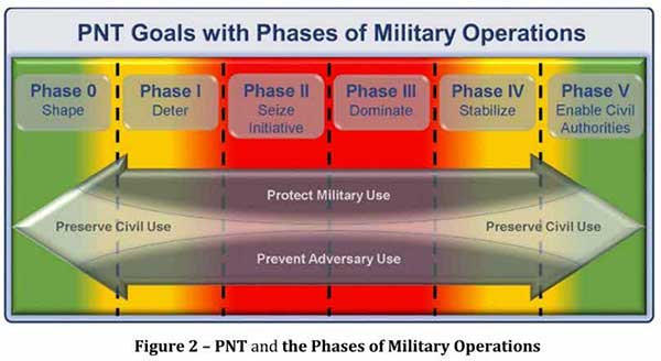
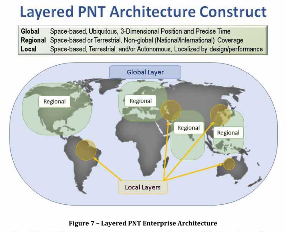
Calling PNT “foundational,” the strategy observes that the U.S. military has over the years structured its weapons systems and business processes around GPS PNT. This has created a tremendous dependence and associated vulnerability.
Added to this threat is the realization that “At the same time, it is increasingly clear… GPS will be targeted and will not always be available in contested military operating areas, or perhaps globally.”
Multiple diverse sources of PNT
One of the primary ways DoD will deal with is this is to access multiple diverse sources of PNT. These will be in a multi-layered architecture of global, regional and local services.
The strategy envisions GPS, paired with military-grade receivers, as the primary global layer source. It recognizes that allied GNSS will be available, but observes that DoD has not done any accuracy and integrity assessments to determine their usefulness. And, since “…all are vulnerable to the same interference and jamming effects” as GPS, “…other sources of PNT information with different characteristics are necessary.”
The regional layer is defined by systems that service large areas such as a few countries or even continents. Recognizing that regional sources can be in space, the strategy discusses two low-frequency ground-based systems with characteristics much different from satellites — enhanced Loran (eLoran) and spatial, temporal and orientation information in contested environments (STOIC).
“Their high power and low frequency enable regional/nationwide coverage, spectrally separate from GPS services, accessible in buildings and under water, and transmitted from dispersed terrestrial locations. Each can be considered as a possible complement to GPS, depending upon operational circumstances and requirements.”
Short-range radio frequency systems, clock, inertial, sensory and hybrid PNT services integrated with wireless networks are all cited as possible contributors to the local layer of DoD’s PNT architecture.
Modular, open-systems approach
Receivers that employ a modular, open-systems approach that can ingest and integrate the various sources of PNT information are needed to take advantage of this multi-source, multi-layer strategy. And integration of the various sources must be seamless and invisible to the user, unless they decide otherwise.
“The employment of multiple PNT sources should not require user awareness or intervention to switch among alternatives during mission execution unless the user elects that option.”
A critical need for implementing this approach, according to the strategy, is the establishment of PNT input/output standards. The document notes that candidate standards have been developed, and it is vital to finalize and approve the standards and bring them into operational service as soon as possible.
Other provisions
The strategy includes a number of other provisions regarding internal DoD processes, the complicated governance process for PNT within the department, and some complex graphics that may be of interest to the larger PNT community.
It also sends several messages about the department’s desires, intent and concerns in the world of PNT that are worth noting.
NAVWAR. The department’s main defensive capability during navigation warfare will be the use of its layered architecture of PNT information and modular, open-systems integration. For offensive operations, it cautions warfighters to not shoot themselves in the foot. PNT is so vital to a wide variety of allied systems, it warns, that denying it to hostiles could do as much damage to friendly forces.
PNT dominience/superiority. At at time when there are more of China’s brand new BeiDou satellites in the skies of many cities, and China is negotiating with Russia for closer BeiDou/GLONASS integration, the strategy calls for the U.S. DoD to achieve PNT dominance. To date, U.S. PNT leadership has been a big contributor to the nation’s political and military leadership in the world. The strategy seeks to continue this.
Accelerate M-code receivers. The need to get more M-code GPS receivers into the hands of warfighters is mentioned several times. GPS III satellites have been transmitting M-coded signals that are much more resilient to jamming and spoofing than civil signals since late 2018. These are useless, though, without properly equipped receivers in the field.
Future support to Civil PNT. The strategy also seems to show the department is distancing itself from support of future civil PNT endeavors. While GPS has been an incredible economic engine and boon to civil users, this has not always been in DoD’s best interests.
“It must also be recognized that in this context growing civil dependence on GPS services for critical infrastructure and public use will continue to constrain the ability of the DoD to maintain a military PNT advantage from GPS.”
It goes on to warn that future DoD PNT systems and efforts will not follow the same path to civil-military use as was taken by GPS.
“DOD must take steps to ensure the civil agencies are aware of and are sensitive to the dual-use implications inherent in GPS and other PNT Enterprise applications. From this point forward, many of the specific PNT capabilities and combinations of PNT capabilities employed by the DoD for military purposes will increasingly be classified.”
The way ahead for the 99%
It is clear that the Department of Defense, through the very capable leadership of its CIO, Dana Deasy, has a clear idea of where it is with PNT, its critical challenges, and how to overcome them.
This does not appear to be the case for those in the federal government charged with safeguarding the interests of civil users. With responsibilities fragmented across a host of departments and agencies, efforts on behalf of the public at large are barely visible compared to those the Defense Department is taking to protect itself.
According to officials, this may change. They report that leadership of civil PNT within the executive branch is under review with an eye to making it more efficient and effective.
Perhaps it will result in a PNT strategy for the 99% of GPS users who are not connected with the Defense establishment, making them safer and more secure as well.
“Strategy for the Department of Defense Positioning, Navigation, and Timing (PNT) Enterprise” is available online.
The U.S. Department of Transportation is preparing for a GPS backup and complementary positioning, navigation and timing demonstration for the Department of Defense at the Joint Base Cape Cod, Massachusetts.
Demonstration for testing is expected to begin in the spring of 2020, and DOT is seeking contractors to make Building #2410 at the base functional so that the demonstrations can be held there.
Diana Furchtgott-Roth, deputy assistant secretary of Transportation for Research and Technology, is leading the project. Working through the Volpe National Transportation Systems Center, Furchtgott-Roth’s goal is to demonstrate as many of the technologies as possible and conclude the effort by March of next year.
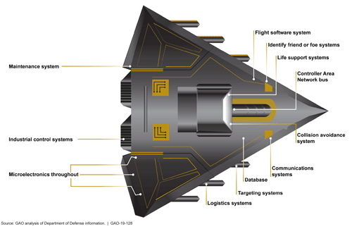
In a 50-page report to the U.S. Senate Armed Services Committee, the government’s General Accounting Office (GAO) finds that U.S. weapons systems are, almost across the board, highly vulnerable to cyber-attack. Furthermore, the Department of Defense (DoD) has gotten off to “a late start” in prioritizing cybersecurity, and has only “a nascent understanding” of how to develop more protected weapons systems. The October 2018 report, “Weapons Systems Cybersecurity,” is subtitled “DoD Just Beginning to Grapple with Scale of Vulnerabilities.”
[Image above: Figure 2 from the GAO report: Embedded Software and Information Technology Systems Are Pervasive in Weapon Systems, represented via Fictitious Weapon System for Classification Reasons). Source: GAO analysis of Department of Defense information, GAO-19-128.]
GPS can figure to be among these threatened systems, and GPS guidance aboard many munitions and almost all platforms vastly expands the danger. The satnav system is not mentioned by name in the report (“To present information in an unclassified format, we do not disclose details regarding weapon system vulnerabilities, which program offices we interviewed, or which cybersecurity assessments we reviewed.”), and the word navigation surfaces only once, but it’s an alarming appearance:
“Weapon systems are dependent on external systems, such as positioning and navigation systems and command and control systems in order to carry out their missions—and their missions can be compromised by attacks on those other systems. A successful attack on one of the systems the weapon depends on can potentially limit the weapon’s effectiveness, prevent it from achieving its mission, or even cause physical damage and loss of life.”
The latter scenario could occur if a GPS-guided armament were hacked and rerouted to a civilian target, for example.
The GAO states that it warned as far back as 2015, and in repeated instances since that date, that federal and contractor systems face an evolving array of cyber-based threats, including criminals, hackers, adversarial nations, and terrorists. “Threats can range from relatively unskilled “script kiddies” who only use existing computer scripts or code to hack into computers, to well-resourced and highly skilled advanced threats who not only have sophisticated hacking skills, but also normally gather detailed knowledge of the systems they attack.”
Networks, Computers Increase Vulnerabilty
The increasingly computerized and networked nature of the U.S. military’s weapons contributes to their vulnerability. As weapon systems become more software- and IT-dependent and more networked, they actually become more vulnerable to cyber-invasion. Networks can be used as a pathway from one accessed weapon to attack other systems.
“Nevertheless,” the report adds, “until recently, DOD did not prioritize cybersecurity in weapon systems acquisitions. . . . DOD is in the early stage of trying to understand how to apply cybersecurity to weapon systems.”
As the GPS constellation — the satellites themselves as well as the ground control system — become more software-reliant, including the ability to modify signals by remote software command, this has to be a growing concern for the U.S. Air Force. Difficulties with cyber-proofing the next-generation ground control system, OCX, have been suspected as a leading cause of extended delivery delay in that program.
DoD officials reportedly confided that it will take time — and possibly some missteps — to learn what does and does not work in combatting cyber-attacks on weapon systems.
Separately, a UK defense expert consultant stated that Russia had “stolen a march on using cyber-capabilities at a tactical level on the battlefield.” As reported last year in GPS World, Black Sea spoofing incidents aroused suspicion that Russia was testing a new counter-combat technique.
Another spoofing expert said at the time, “It’s long been assumed that Russia, China and other nations (including the U.S.) have the technology to carry out a spoofing attack. What’s surprising is Russia’s willingness to use it openly and somewhat indiscriminately. It does fit nicely into what has been called Russian disinformation technology.”
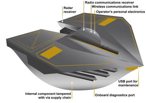
Figure 3 from the GAO report: Weapons Include Numerous Interfaces That Can Be Used as Pathways to Access the System (Represented via Fictitious Weapon System for Classification Reasons) Source: GAO analysis of Department of Defense information, GAO-19-128.
The amount of software embedded in weapon systems and subsystems has increased exponentially, expanding the respective weapons’ vulnerable surfaces. According to the military’s Director of Operational Test and Evaluation, “any exchange of information is a potential access point for an adversary. Even “air gapped” systems that do not directly connect to the Internet for security reasons could potentially be accessed by other means, such as USB devices and compact discs. Weapon systems have a wide variety of interfaces, some of which are not obvious, that could be used as pathways for adversaries to access the systems, as is shown in Figure 3.”
If attackers can access one of those systems, they may be able to reach any of the others through connecting networks.
Figure 4 from the GAO report: Weapon Systems Are Connected to Networks That May Connect to Many Other Systems (Notional Depiction for Classification Reasons)
Further, the DOT&E found that some networks were not survivable — that is, able to maintain critical capabilities under applicable threat — in a cyber-contested environment. The Defense Science Board concluded in 2013 that “the adversary is in our networks.”
The GAO adds that it and other organizations have been sounding off about such threats since the early 1990s — around the time that GPS itself became operational.
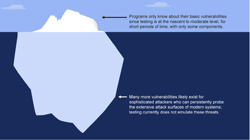
Tests of major military programs conducted between 2012 and 2017 revealed mission-critical cyber vulnerabilities that adversaries could compromise. “Test teams were able to gain unauthorized access and take full or partial control of these weapon systems in a short amount of time using relatively simple tools and techniques. . . . Once they gained initial access, test teams were often able to move throughout a system, escalating their privileges until they had taken full or partial control of a system.”
Figure 5: Vulnerabilities that the Department of Defense Is Aware of Likely Represent a Small Amount of Actual Vulnerabilities Due to Limitations in Cybersecurity Testing. Source: GAO analysis of Department of Defense information, GAO-19-128.
Beginning Steps
The Department of Defense is “still learning” how to address weapon system security and “still determining” what steps it may take. Implementation, once identified, will surely occupy an extended period. Complicating the picture, if DOD is able to make its newer systems more secure, yet connects them to older, vulnerable systems, the newer systems come into jeopardy.
Pass the Hash
A report appendix lists several different types of attacks with such pictorial names as: Man-in-the middle, Pass-the-hash, War driving, and Zero day exploit.
Respectively, these types of attacks connote:
• An eavesdropping attack in which the attacker intercepts to read or modify data communications to masquerade as one or more of the entities involved.
• Capturing an encrypted version of a username and password in order to authenticate to a server or service. The attacker does not have to decrypt the username and password (i.e., they do not actually know what they are), yet can still use them to log in to a system.
• Driving through cities and neighborhoods with a wireless-equipped computer — sometimes with a powerful antenna — searching for wireless networks potentially to exploit.
• Taking advantage of a security vulnerability previously unknown to the general public. In many cases, the exploit code is written by the same person who discovered the vulnerability. By writing an exploit for the previously unknown vulnerability, the attacker creates a potent threat since the compressed timeframe between public discoveries of both makes it difficult to defend against.
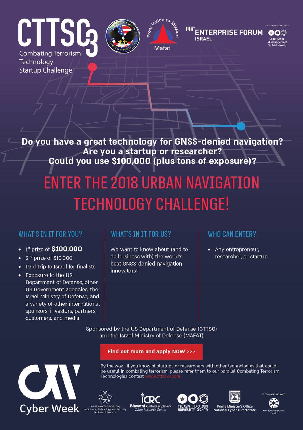
The U.S. Department of Defense (DoD) and Israel’s Ministry of Defense are joining forces for the third time in setting up a startup competition to tap into new technologies to beat terrorism. More than $200,000 in prizes will be awarded to the most promising startups.
“As terrorists become ever more sophisticated, technological innovations become an increasingly critical component of detecting and defeating them,” challenge organizers said.
The challenge is is divided into two tracks.
The Urban Navigation Technologies Challenge focuses on navigating without GPS — an increasingly important issue for special forces, law enforcement and other anti-terrorism professionals who need to operate indoors or in environments where GPS is not available. (See more below.)
The General Technologies Challenge includes surveillance, social media analytics, image and video, cybersecurity, drones, robotics, personal protection, biometrics, reconnaissance, and detection of explosives or water contamination.
Both tracks are open to all startups, entrepreneurs, and research groups worldwide, with a deadline of March 9. Entries will be reviewed by an international panel of judges from the DoD, Israel Defense and other organizations.
The most promising startups will be invited to present at the Combating Terrorism Technology Conference in Tel Aviv University on June 17.
Navigation Challenge
Entries in Urban Navigation Challenge might include location services based on beacons, technologies incorporating pre-loaded maps, technologies that estimate a user’s position via dead-reckoning or step-counting, and any other technology for navigating or positioning with no GPS.
Technologies may include: laser, inertial, vision, simultaneous localization and mapping, dead reckoning, pre-installed beacons or other infrastructure, pre-loaded maps, Wi-Fi, cellular or any other solution that operates in a GNSS-denied environment.
The winning startup will receive a $100,000 prize and a runner-up receives $10,000.
In addition, Navigation Challenge finalists will demonstrate their technologies in a dedicated urban navigation test facility in Israel.
The Government Accountability Office (GAO) recommends the U.S. Department of Defense (DOD) assign responsibility to an organization to collect test data, lessons learned and design solutions in its effort to meet GPS modernization goals.
According to the GAO, “The Secretary of Defense should ensure that the Under Secretary of Defense for Acquisition, Technology and Logistics, as part of M-code receiver card acquisition planning, assign an organization with responsibility for systematically collecting integration test data, lessons learned, and design solutions and making them available to all programs expected to integrate M-code receiver cards.”
DOD concurred with the recommendation.
The GAO presented its findings in a 53-page report issued Dec. 12, “Global Positioning System: Better Planning and Coordination Needed to Improve Prospects for Fielding Modernized Capability.”
According to the GAO, “DOD has made some progress on initial testing of the receiver cards needed to utilize the M-code signal. However, additional development is necessary to make M-code work with over 700 weapon systems that require it.
“DOD has begun initial planning for some weapon systems, but more remains to be done to understand the cost and schedule needed to transition to M-code receivers.
“The preliminary estimate for integrating and testing a fraction of the weapon systems that need the receiver cards is over $2.5 billion through fiscal year 2021 with only 28 fully and 72 partially funded (see below figure). The cost will increase by billions when as yet unfunded weapon systems are included.”
Status of weapon systems that have determined the cost needed to transition to M-code receivers through Fiscal Year 2021, as of February 2017.
In its summary, the GAO wrote “DOD faces risks as it simultaneously develops satellites, a ground system to operate them, and receiver cards that allow use of GPS signals. It will need to install receiver cards on hundreds of systems and, without better coordination, risks paying repeatedly to solve similar problems across the systems.”
The report also assesses the extent to which DOD faces acquisition challenges in sustaining the GPS constellation and developing a new ground control system. The GAO analyzed GPS quarterly acquisition reports and data, acquisition strategies, software and test plans, and other documents, and interviewed DOD and contractor officials.