Tag: EGNOS

  • Joint venture expands SBAS for business development in Africa

    Joint venture expands SBAS for business development in Africa

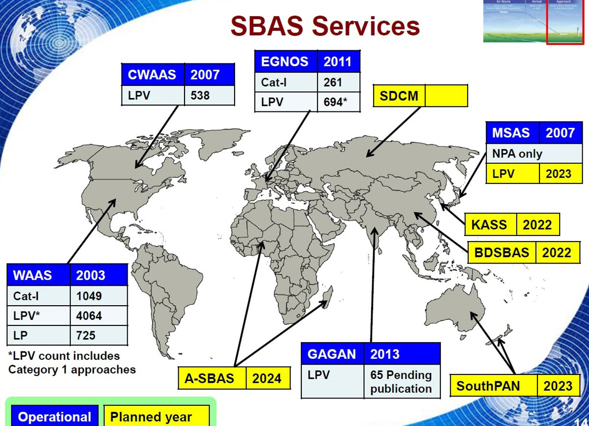
    A team of companies and government agencies is developing satellite services provided by ASECNA’s A-SBAS (Satellite-Based Augmentation System) for Africa and the Indian Ocean. Besides the current SBAS, the joint venture will deliver precise point positioning (PPP, through CNES and Geoflex) and danger warnings for a wide range of applications in Africa.

    Working together are the Agency for Air Navigation Safety in Africa and Madagascar (ASECNA), Nigerian Communications Satellite Ltd. (NIGCOMSAT) and Thales Alenia Space, the joint venture between Thales (67%) and Leonardo (33%). The project is backed by Geoflex, a provider of cloud services that deliver improvements to GPS/GNSS applications to achieve positioning accuracy to within 4 centimeters on land, at sea and in the air.

    The new SBAS services are expected to aid agriculture and other sectors in Africa. Here,volcanic cinder cones and farming in rich volcanic soils on the border of the Democratic Republic of Congo and Rwanda. (Photo: iStock/Getty Images Plus)
    The new SBAS services are expected to aid agriculture and other sectors in Africa. Here,volcanic cinder cones and farming in rich volcanic soils on the border of the Democratic Republic of Congo and Rwanda. (Photo: iStock/Getty Images Plus)

    Demonstrations

    The three partners successfully demonstrated the additional services on July 7 and 8 in Brazzaville, Congo, by calling on the SBAS signal they have broadcast over the Africa and Indian Ocean (AFI) region since September 2020 to provide the first SBAS open service in this part of the world via the NigComSat-1R satellite. This trial follows successful flight demonstrations this year in Lomé in January and Douala in June.

    The first demonstration of the special urgent situation warning service via satellite showed the system’s ability to broadcast a warning message via the A-SBAS signal to mobile phones, without requiring a terrestrial network. This service sends a message to the populations concerned, providing information on the type of danger and instructions to be followed.

    The second demonstration entailed the transmission of GNSS corrections based on CNES/Geoflex PPP technology and also using the A-SBAS signal. This approach showed the system’s ability to achieve positioning accuracy to within centimeters across the entire African continent.

    The new satellite service paves the way for applications in a broad range of sectors, including precision agriculture, land and maritime transport, rail safety, drone navigation, mapping and surveying. The ASECNA SBAS was developed as part of the ‘’SBAS for Africa & Indian Ocean’’ programme as a first step towards providing robust navigation services in the aviation sector.

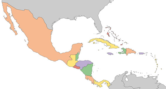
    ASECNA’s 18 Member States are Benin, Burkina Faso, Cameroon, Central African Republic, Comoros, Congo, Côte d’Ivoire, France, Gabon, Guinea Bissau, Equatorial Guinea, Madagascar, Mali, Mauritania, Niger, Senegal, Chad and Togo.

  • Galileo Center for Mexico, Central America and Caribbean opens in Mexico City

    Galileo Center for Mexico, Central America and Caribbean opens in Mexico City

    A new Galileo Information Center for Mexico, Central America and the Caribbean has opened in Mexico City, with training facilities in Querétaro, Mexico. The 177-million population is a largely untapped market for space, according to Telespazio Ibérica.

    Telespazio Ibérica will run the center as leader of a consortium composed of European and local industrial and institutional partners such as everis, Enaire, Geotecnologías, and universities including the Universidad Politécnica de Madrid and the Universidad Nacional Autónoma de México.

    The center is co-financed by the Directorate-General for Defence Industry and Space (DG DEFIS) of the European Commission for 36 months. Its goal is to enlarge the ecosystem of Galileo Information Centers as it joins two existing centers in Chile and Brazil, active since November 2019. The centers contribute to the European Commission’s outreach to promote the EU Space Programme and foster its market uptake in Latin America.

    The new center will help improve visibility of European satellite navigation and promote cooperation on Galileo and EGNOS between the EU space ecosystem and regional stakeholders. This includes building valuable insights on local GNSS markets, monitoring local and regional satellite navigation initiatives, and seeking to understand regional needs and the market potential for European GNSS. The center will provide communication, promotion and training activities.

    “Telespazio Ibérica already plays a key role in the Galileo Service Center  in Madrid,” said Miguel Bermudo, CEO of Telespazio Ibérica. In Madrid, the company operates on behalf of Spaceopal, a joint venture between Telespazio and the German Space Agency DLR, under the GSA contract for the Galileo Service Operator.

    “We have chosen to co-finance this project with DG DEFIS to promote Galileo in Mexico, Central America and the Caribbean,” Bermudo said, “considering its presence in this important region to be of a great strategic value both in promoting the use and applications offered by Galileo and the opportunity it represents for Telespazio Group.”

    Image: ii-graphics/iStock/Getty Images Plus/Getty Images
    Image: ii-graphics/iStock/Getty Images Plus/Getty Images
  • Next 10 years of EGNOS to focus on drones

    Next 10 years of EGNOS to focus on drones

    Europe’s EGNOS satnav system has been providing safety-of-life services for 10 years. EGNOS, the European Geostationary Navigation Overlay Service, transmits signals from a duo of satellite transponders in geostationary orbit.

    The satellite-based augmentation system (SBAS) gives additional precision to U.S. GPS signals, delivering an average precision of 1.5 meters over European territory, as much as a 10-fold improvement over unaugmented signals. EGNOS also provides confirmation of GPS signal integrity through additional messaging identifying any residual errors.

    While the EGNOS Open Service has been in general operation since 2009, EGNOS began its safety-of-life service in March 2011.

    The European Space Agency (ESA) designed EGNOS as the European equivalent of the U.S. Wide Area Augmentation System (WAAS), working closely with the European air traffic management agency Eurocontrol. ESA then passed EGNOS to the European GNSS Agency (GSA) to run operationally.

    Guiding airliners

    EGNOS’s primary customer is aircraft. Without guidance from the ground, pilots using EGNOS can confidently descend in bad weather to 60 meters’ altitude before needing to make visual contact with the tarmac.

    On March 17, 2011, France’s Pau Pyrénées Airport was the first airport to use EGNOS. Today, more than 385 airports and helipads and 60 airlines across Europe use EGNOS-based LPV-200 approaches (short for Localizer Performance with Vertical guidance – 200 feet). The EGNOS service requires no ground equipment, and replaces the radio guidance beamed upward by traditional CAT I instrument landing system (ILS) infrastructure with no decrease in performance.

    As of March 2021, more than 385 airports and helipads and 60 airlines across Europe are using EGNOS-based LPV-200 approaches. (Image: ESA)
    As of March 2021, more than 385 airports and helipads and 60 airlines across Europe are using EGNOS-based LPV-200 approaches. (Image: ESA)

    Serving drones

    EGNOS is now being eyed as the enabler of unmanned aerial vehicles (UAVs). The GSA has supported numerous trials of drones equipped with EGNOS as well as Galileo through its EGNSS4RPAS project. Crewed aircraft are expected to be vastly outnumbered in our skies by all kinds of UAVs, employed for everything from weather and environmental monitoring to personalized delivery services.

    U-Space is Europe’s program to integrate drones into the airspace. (Image: ESA)
    U-Space is Europe’s program to integrate drones into the airspace. (Image: ESA)

    The traditional person-based air traffic control model will need to evolve to accommodate such a shift, based on automated monitoring, traffic management and collision avoidance. In Europe, this highly automated version of air traffic control is termed U-space.

    EGNOS’s safety-of-life service is essential to making this happen, moving from today’s situation — where drones are limited to specific air corridors and line-of-sight operations — to let them roam freely but safely in busy airspace and built-up areas.

    “The whole idea behind EGNOS’s safety-of-life has been to render satellite navigation sufficiently reliable for any kind of use,” explained Didier Flament, who leads ESA’s EGNOS team. “After 10 years of faultless operations, new applications are becoming plain. Drone flight is one example. EGNOS is also being evaluated for train positioning as well as assisted and autonomous automobile driving.”

    EGNOS, the next generation

    ESA retains responsibility for the system’s evolution, and the middle of this decade should see the debut of its new generation, EGNOS v3.

    “While the current system only works with single-frequency GPS signals, EGNOS v3 will operate on a multi-frequency, multi-constellation basis, able to augment all available satellite signals in both L1 and L5 bands, including Galileo,” Didier said. “The result will be far enhanced performance and reliability.

    “In addition, we are working with developers of other SBAS around the globe to ensure they stay fully interoperable so for instance EGNOS-equipped aircraft can fly between continents on a seamless basis. Such interoperability, combined with the arrival of the other SBAS systems under development in other regions, will lead to a quasi-global worldwide safety-of-life service coverage in the year 2030.”

    Operational and planned satellite-based augmentation systems (SBAS) around the globe. (Image: ESA)
    Operational and planned satellite-based augmentation systems (SBAS) around the globe. (Image: ESA)
  • Alstom pioneers use of Galileo to help measure location and speed of trains

    Alstom pioneers use of Galileo to help measure location and speed of trains

    Photo: Alstrom
    Photo: Alstrom

    News from the European GNSS Agency

    In June, Alstom became the first railway manufacturer to integrate certified data-fusion algorithms for fail-safe train localization, using position and speed of trains based on GNSS data coming from multiple constellations, including Galileo.

    The added value of Galileo and EGNOS in the European railway sector is widely known, especially when it comes to non-safety applications, such asset management and passenger information services.

    In recent years, however, with multi-constellation becoming the norm and multifrequency receivers being adopted rapidly, rail stakeholders view GNSS-based solutions as game-changers for the future of European Train Control System (ETCS).

    A recent example of EGNSS adoption in rail operations is the innovative odometry solution deployed by Alstom to measure the location and speed of its trains. The French rolling-stock manufacturer introduced a new sensor type, with a hybridisation of satellite information and inertial sensors. The solution is primarily using GNSS Doppler information, derived from Galileo, GPS and GLONASS constellations (configurable).

    Such use allows to improve the overall confidence in the resulting speed, along with specific algorithms to master the resulting location accuracy. The GNSS receiver is an automotive grade receiver manufactured by u-blox. The inertial measurement unit (IMU) used to supplement information in case of GNSS loss is based on enhanced micro-electromechanical systems (MEMS) technology, with temperature compensation.

    The new odometry system based on data fusion, which Alstom is currently implementing in Norway, is applicable to all types of trains and all environments, including the harshest weather conditions. It is estimated that by 2026, 450 trains will be equipped with this new feature across Norway.

    Increased safety, lower costs for rail companies

    Wheel slipping and sliding especially during demanding weather conditions can affect the odometer accuracy and the proper functioning of the different sensors involved. By incorporating Galileo signals as an extra layer of accuracy, Alstom managed to create a system that is capable of providing a more robust speed and location estimate. This space data fusion approach —certified by Belgorail — minimizes the need for the costly external radar components for localisation and speed measurement currently used.

    “Industry embedding Galileo in their solutions is the proof that we are on the right path to ensure the market uptake of the EU Space Programme technology,” said Rodrigo da Costa, GSA executive director. “This is a recognition of the capability of EGNSS to reduce the need for infrastructure and related cost, while maintaining the operational safety of ETCS.”

  • Rodrigo da Costa begins role as new GSA director

    Rodrigo da Costa begins role as new GSA director

    On Oct. 16, Rodrigo da Costa took up his duties as executive director of the European GNSS Agency (GSA), soon to become the EU Space Programme Agency.

    He was elected by the GSA Administrative Board on Sept. 15 and met with the ITRE Committee of the European Parliament on Oct. 12.

    Da Costa, a Portuguese national who has worked in a number of EU countries, joined the GSA as the Galileo Services Programme manager in March 2017. In this position he was responsible for leading Galileo, the European Union GNSS, in its service provision phase.

    He has previously held several senior project management, business development, and institutional account management positions in space industry, in the areas of human space flight, exploration, launchers and research and development.

    Da Costa will now be working on transforming the GSA into the EU Space Programme Agency (EUSPA). He will ensure that its existing activities continue to be successfully delivered while also performing new ones required to undertake with the Agency’s new mandate.

    Since its creation in 2004, the GSA has made an unparalleled contribution to the EU flagship satellite systems Galileo and EGNOS, which have significantly contributed to the union’s independence and economic growth.

    Staffed with highly skilled and dedicated personnel, the agency has boosted innovation, fostered entrepreneurship, led the provision of services, and stimulated the EU economy, in particular through ensuring Galileo and EGNOS uptake across a wide range of market segments thanks to high-quality and secure satellite services.

    Rodrigo da Costa, executive director of the European GNSS Agency. (Photo: GSA)
    Rodrigo da Costa, executive director of the European GNSS Agency. (Photo: GSA)

    With eyes fixed on the future, EUSPA will further build on the work of the GSA, and will take on additional new responsibilities for further components to the EU Space Programme, including activities in Copernicus (the European Earth observation programme), GOVSATCOM (the EU secure satellite communication system).

    Commenting on his new duties da Costa said: “Becoming Executive Director of the Agency means, above all, to lead a team of excellent, dedicated professionals. I’m immensely excited by the opportunity we have to build a successful EUSPA, a key contributor of the EU Space Programme. I’m looking forward to working with all our stakeholders. The task is vast, but I am confident we will be able to play our part, demonstrating to EU citizens what we can do together in EU space activities as GSA/EUSPA.’’

  • Europe issues tender for GNSS high-accuracy evolution

    Europe issues tender for GNSS high-accuracy evolution

    Image: ESA
    Image: ESA

    The European Commission (EC) is seeking help to build a roadmap for high-accuracy Galileo and EGNOS services.

    The EC Directorate-General for Defence Industry and Space (DG-DEFIS) has issued an Invitation to Tender for a service contract to address how the future evolution of European GNSS (EGNSS) could be beneficial for innovative demanding applications.

    The new service contract will assess the feasibility of an integrity service complementing EGNSS high accuracy in the 2030+ timeframe.

    The new service contract will feed into the evolving needs of demanding new applications without disrupting the current business models of established service providers, according to the European GNSS Agency. The tender will assess various steps needed for the Galileo and EGNOS services to evolve.


    A webinar to explain the framework and objectives of the procurement and the different tasks in the procurement is planned on September 23 at 16:00 CEST.


    Emerging and next-generation applications will require more demanding positioning solutions to be able to offer innovative services. The use of an integrity service complementing European GNSS (EGNSS) High Accuracy in the 2030 horizon could result in the provision of an accurate and reliable positioning solution that would translate into the overall improvement of future innovative and demanding services.

    As part of the services provided by Galileo, the Galileo High-Accuracy Service (HAS) will provide high-accuracy positioning and synchronization information, the EC said.

    EGNOS version 3 will extend the service area to the entire landmasses of EU Member States. New EGNOS services could be implemented in further releases of EGNOS as an option for the integrity service complementing EGNSS High Accuracy.

  • ASECNA, Thales provide African early SBAS open service

    ASECNA, Thales provide African early SBAS open service

    Service opens a new era of satellite navigation performance augmentation in the Africa and Indian Ocean Region

    Photo:The Agency for Air Navigation Safety in Africa and Madagascar (ASECNA) has started to broadcast a satellite-based augmentation system (SBAS) signal over Africa and the Indian Ocean (AFI) region.

    This is the first SBAS open service in this part of the world, according to Thales Alenia Space. The signal is broadcast via the NIGCOMSAT-1R satellite managed and operated by Nigerian Communications Satellite Ltd. under the Federal Ministry of Communications and Digital Economy of Nigeria.

    The early open service is provided as part of the “SBAS for Africa & Indian Ocean” program, which pursues the autonomous provision over the continent of SBAS services to augment the performances of the satellite navigation constellations GPS and Galileo.

    With improved accuracy to within a meter — and boosted integrity, availability and continuity of safety-related applications — the SBAS services will improve flight safety and efficiency in Africa. It will also benefit the economy in land, sea and rail transport areas, as well as mass-market applications, supporting user safety, cost-effectiveness and sustainable development.

    Early Service Goals

    The launched open service aims to carry-out technical trials, and to undertake with partner airlines field demonstrations for aircraft to demonstrate the benefits of the future operational safety-of-life SBAS services, expected in 2024. It will also include early precise point positioning (PPP) and emergency warning service, both to be demonstrated.

    The signal in space is generated by a dedicated system testbed, developed as part of the “SBAS for Africa and Indian Ocean” preliminary design phase, financed by the European Union and awarded to a Thales Alenia Space joint venture between Thales (67%) and Leonardo (33%). The system prototype uses the SAGAIE reference station network deployed by CNES and ASECNA with the support of Thales Alenia Space.

    The signal is broadcast via the SBAS payload on Nigcomsat-1R GEO satellite of the Nigerian Communications Satellite and an uplink station deployed in Abuja (Nigeria). It is compliant to the Standards and Recommended Practices of the International Civil Aviation Organisation, and the Minimum Operational Performance Standard developed by the RTCA (Radio Technical Commission for Aeronautics) organization. It will be visible in the whole Africa and Indian Ocean, up to the West Australian coast, and also in Europe.

    “We are proud to be part of this ambitious program to provide satellite navigation services in the Africa and Indian Ocean region. The use of our geostationary communication satellite Nigcomsat-1R navigation payload to broadcast the first signal will be Africa’s premier contribution to SBAS as a regional satellite-based augmentation system for the continent,” said Abimbola Alale, MD/CEO of NIGCOMSAT Ltd.

    “Our long-standing expertise acquired with the development of EGNOS SBAS in Europe and KASS SBAS in Korea combined with our new leading-edge satellite positioning technologies makes Thales Alenia Space the ideal partner to best support countries to implement their own SBAS efficiently. The equatorial region represents also a key engineering challenge for such a system due to difficult ionosphere conditions, for which Thales Alenia Space has developed a proven solution,” said Benoit Broudy, vice president of the Navigation business at Thales Alenia Space in France.

    “The provision of the first African SBAS early service is a crucial major step forward in the development of satellite navigation in the AFI Region, and in the deployment of the ‘SBAS for Africa and Indian Ocean’ system, the navigation solution for Africa by Africa. It demonstrates the ambition and commitment of ASECNA to enhance air navigation safety for the benefit of the whole continent, in line with my vision for the unification of the African Sky,” stated Mohamed Moussa, director general of ASECNA.

    About ASECNA

    ASECNA is an international public organization. Its main mission is to provide air navigation services within an airspace of 16,500,000 square kilometers, divided into six flight information regions (F.I.R) as defined by the International Civil Aviation Organization (ICAO).

    ASECNA also develops solutions for airport management, aviation infrastructure studies and construction, equipment maintenance, calibration of air navigation instruments and training for civil aviation staff.

    Its 18 Member States are: Benin, Burkina Faso, Cameroon, Central African Republic, Comoros, Congo, Côte d’Ivoire, France, Gabon, Guinea Bissau, Equatorial Guinea, Madagascar, Mali, Mauritania, Niger, Senegal, Chad and Togo.

  • GSA and CLGE accepting submissions for Geomatics on the Move 2020 competition

    GSA and CLGE accepting submissions for Geomatics on the Move 2020 competition

    Logo: Geomatics on the Move competition

    The European GNSS Agency (GSA), in collaboration with the Council of European Geodetic Surveyors (CLGE), has launched the Geomatics on the Move 2020 competition. The event aims to foster the use of European Union (EU) satellite programs Galileo, EGNOS and Copernicus among students, young professionals, entrepreneurs and small and mid-sized businesses to create innovative geomatics applications and solutions across all over Europe.

    Building and expanding on the CLGE Student Contest, which has been held for the past nine years, the new Geomatics on the Move Prize Contest targets applications that integrate the use of additional technologies such as artificial intelligence, machine learning, augmented and virtual reality, as well as supplementary remote sensing data sources like drones, GSA said. Solutions animated through mobile phone applications or other easy-to-use platforms are also accepted.

    “This is the ninth year of partnership between the Council of European Geodetic Surveyors and the GSA; over the years we have seen some exciting and innovative solutions emerge that leverage the EU Space Programme to deliver practical solutions for the mapping and surveying community,” said GSA Acting Executive Director Pascal Claudel. “This year, as we recover from this global setback, I look forward to seeing even more novel ideas — from all over the European Union — able to respond to current and future challenges.”

    The competition will be organized in two stages. The first phase is an open call for ideas, during which applicants submit posters describing their ideas. The deadline for these submissions is Oct. 16.

    The proposals then will be evaluated by the GSA and CLGE, and a maximum of 10 projects will be chosen to present their pitch during the finals. The selected applicants will refine their poster and prepare their pitch, for which technical support and training will be made available.

    The official award of the Geomatics on the Move prize contest will take place virtually, during the European Space Week, taking place Dec. 7-11. During this event, finalists will present their solutions to the evaluation board, and winners will be announced on the official contest site.

    With an overall prize of €30 000, a set of 10 prizes will be offered in two categories. The first of these categories targets EU space-based traditional geomatics solutions and the second targets integrated geomatics solutions. he first category is looking for solutions in which the main innovation is based on the use of EGNSS, employing traditional equipment such as surveying or GIS grade GNSS receivers for applications such as cadastral, marine and mining surveying or GIS mapping. The integrated geomatics category targets integrated surveying solutions that use Galileo or EGNOS and leverage cutting-edge tools and technologies such as drones, mobile mapping, laser scanners or augmented/,mixed reality, both within geomatics applications or beyond.

  • MyGalileoDrone competition seeks UAV innovations

    MyGalileoDrone competition seeks UAV innovations

    The European GNSS Agency (GSA) has launched the MyGalileoDrone competition.

    The contest targets the design and development of drone-based applications or services, using a Galileo-enabled receiver, to address the European Union’s (EU’s) key priorities such as the Green Deal, and support the EU Recovery Plan for Europe.

    Initial ideas should be submitted by Aug. 31. Wide participation from all EU Member States is expected.

    According to ESA, the MyGalileoDrone competition seeks to tap into the EU’s innovative spirit to deliver applications and services to boost Europe’s competitiveness, resilience and sustainability. Applications should leverage and demonstrate Galileo’s added value, such as increased accuracy, availability and robustness of position, as well as integrity for a solution based on drone operations.

    Drones applications

    Photo: © GSA
    Photo: ©GSA

    The market related to drone applications and services is growing rapidly, and European drone service revenues are expected to reach EUR 250 million by 2025. The European demand is estimated to reach EUR 10 billion annually, in nominal terms, to 2035 and over EUR 15 billion annually to 2050, creating more than 100,000 jobs.

    With GNSS receivers implemented on almost all new commercial drones, Galileo’s and EGNOS’ added value is pivotal for the development and growth of drone services and applications.
    In addition to designing and developing the application, contestants should prepare their drone- based application or service for commercial launch.

    The solution should leverage Galileo to provide a position fix. The use of EGNSS is understood in the broad sense, and Galileo can be integrated in the flying platform, the ground control station, or in other devices supporting the operation, such as a smartphone or even in the frame of U-Space services.

    “GNSS is a key enabling technology in this segment, ensuring robust navigation and reliability for a wide range of applications. The MyGalileoDrone competition aims to bring oxygen to European SMEs and entrepreneurs driving innovation. It will create jobs and growth in this promising market,” said Pascal Claudel, acting executive director at the GSA.

    Focus on EU priorities

    In times of post-COVID recovery focus, submissions should target applications and services that support key EU priorities, but the sky’s the limit. The GSA is looking for trailblazing ideas in applications such as smart mobility, sustainable agriculture or environmental protection, or solutions that exploit synergies between 5G and space data, or support the internet of things, or whatever might be the next big thing.

    Deadlines and Prizes

    The first prize in the MyGalileoDrone competition amounts to EUR 100,000, with EUR 60,000 for second, EUR 40,000 for third, and a fourth prize of EUR 30,000.

    After Aug. 31, projects selected to advance to the development phase of the contest will be announced on Sept. 15. Participants will  have until Nov. 30 to develop a demo version of their proposed application or service.

    In the finals, the selected teams will perform a live demonstration and pitch their ideas to investors. During the development process, the applicants will receive mentoring and coaching from recognized experts in the drone market. These experts will accompany them as they build their application, develop tests and get ready from the business perspective to attract investors and move to market.

    To register or for more information, visit the competition page on the GSA website.

  • SUGUS project launches survey for drone users, GNSS communities

    SUGUS project launches survey for drone users, GNSS communities

    Image: Tanaonte / iStock / Getty Images Plus / Getty Images
    Image: Tanaonte / iStock / Getty Images Plus / Getty Images

    SUGUS — a European Commission project to promote European GNSS services for the integration of drones into the airspace — is conducting an online survey of stakeholders.

    SUGUS, the European Commission’s project for the development of European GNSS (Galileo and EGNOS) services for U-space, is carrying out a survey to identify, gather and understand stakeholders’ needs, and to improve user experience of E-GNSS in complex operations and built-up areas.

    U-space is a set of new services and specific procedures designed to support safe, efficient and secure access to European airspace for large numbers of drones.

    SUGUS members invite all the stakeholders to take part in the survey, including suppliers of U-space services, manufacturers of unmanned aerial systems (UAS) platforms and GNSS receivers, UAS pilots and operators, public bodies, authorities and organizations, and centers for UAS testing and training.

    The survey will be available until May 15.

    The survey results will be used as a valuable input to tailor the E-GNSS Service Provision layer to specific drone missions’ needs, allowing a better mitigation of risks in complex operations like BVLOS (beyond visual line of sight) and UAM (urban air mobility), increasing safety and security.

    Also, the points of view collected will help to define the requirements and then the implementation of a new E-GNSS-based API which will deliver live and forecast information about performance, coverage, alerts to users and more.

    The API will be called upon by UTM service providers, UAS designers or UAS systems developers, and integrated in existing commercial solutions.

    “The survey organized by SUGUS is a key element for E-GNSS Programs to capture user requirements of the drone community,” explained Miguel Aguilera, European Commission advisor. “The results will be used to enhance EGNOS and Galileo Service Provision targeting drone operations, increasing safety and security, and facilitating a swift and efficient deployment of U-space.”

    SUGUS Project

    SUGUS (Solution for E-GNSS U-Space Service) is a European Commission’s project to promote European GNSS services (EGNOS and Galileo) for the drone market and for the effective and safe integration of these aerial platforms in the airspace.

    It is a European Union H2020 R&D project to be carried out by GMV (main contractor) with everis Aerospace, Defense and Security as co-leaders of a consortium also involving VVA Brussels, ESSP, FADA-CATEC and Unifly.

    SUGUS will help to develop services geared towards the effective integration of drones into the airspace. A series of trials will be held to show the benefits of E-GNSS for drone operators, as well as its approval by aviation authorities.

  • Galileo Masters 2020 open for submissions

    Galileo Masters 2020 open for submissions

    Photo: voyata/iStock / Getty Images Plus/Getty Images
    Photo: voyata/iStock / Getty Images Plus/Getty Images

    The 2020 Galileo Masters are open for submissions. The competition is designed to award applications, services and new ideas that use Galileo and EGNOS, in synergy with other space programs, to respond to pressing needs facing business and society.

    The 2020 competition has three European GNSS Agency (GSA) challenges, themed “Space for Future Generations.”

    The first challenge, the “Space for our Planet Challenge,” aims to tackle climate change and environmental degradation. Services based on data from Galileo, EGNOS and Copernicus Earth observation can be used to mitigate this threat by supporting more environmentally-conscious life choices, resulting in a healthier planet, GSA said.

    The second challenge, the “Space for Being Safe and Healthy Challenge,” seeks out solutions that use downstream space data provided by Galileo, EGNOS and/or Copernicus as key enablers of innovative applications to help stem the spread of COVID-19 pandemic.

    The third challenge, the “Space for Fun Challenge,” targets solutions using data from Galileo and EGNOS in the gaming, sports, leisure and tourism markets, where GNSS enables the monitoring of user performance and helps make augmented reality games even more immersive.

    For all three challenges, there is a cash price of 10,000€, with another 10,000€ awarded to the overall Galileo Masters 2020 winner.

    Registration is free, and entries must be submitted by June 30.

  • Testing suspended on Galileo Batch 3 satellites

    Testing suspended on Galileo Batch 3 satellites

    In response to the ongoing coronavirus pandemic, the test campaign for the first two satellites of Galileo’s Batch 3 has been suspended.

    The suspension is based on the medical advice for social distancing — too high a concentration of people is needed on site if testing were to continue, according to the European Space Agency (ESA).

    An aerial view of ESTEC. The Erasmus building is at front right. The T building (home to ESA's Galileo team) is in the foreground. (Photo: ESTEC)
    An aerial view of ESTEC. The Erasmus building is at front right. The T building (home to ESA’s Galileo team) is in the foreground. (Photo: ESTEC)

    The satellites are based at the ESTEC Test Centre in the Netherlands for engineering tests ahead of launch. The stored satellites are being monitored by staff visiting ESTEC every few days, to verify that all is in order.

    Other Galileo-related testing continues with the aim of supporting future launches. ESTEC-based lifetime testing of the next set of rubidium atomic clocks is set to continue, involving on-site monitoring every few days.

    Working from home

    ESA’s Directorate of Navigation has shifted to teleworking while also ensuring the continuity of essential tasks, in particular the continued delivery of positioning, navigation and timing services of both Galileo and EGNOS.

    The ESA team is using video and audio conferences to continue meetings with the industries involved and minimize the impact on the deliveries of EGNOS upgrades, Galileo Batch 3 satellites, and preparatory work for Galileo Second Generation.

    The national, local and industrial decisions on travel, meetings and quarantine are impacting the ability to deliver all ongoing commitments, so measures are being taken to minimize their impact, ESA said in a press release.

    Priority has been given to ensure continued operations of both EGNOS and Galileo, so the ESA Navigation Directorate has been supporting the European GNSS Agency (GSA), the operator of Galileo and EGNOS, on behalf of the European Commission.

    The team also is maintaining constant contact with various stakeholders.

    NAVISP and Horizon 2020

    Research and development projects under the Directorate’s Navigation Innovation and Support Programme (NAVISP) are continuing at a somewhat slower pace, given the crisis. So are satellite navigation projects financed by the EU’s Horizon 2020 programme, which develop future technology for the EU satellite navigation projects.

    “Confronted with this unprecedented situation, our efforts are focussing on business continuity and supporting the GSA with services provision of Galileo and EGNOS, while taking all necessary measures to protect our personnel,” said Paul Verhoef, ESA Director of Navigation. “An impact assessment will only be possible when we see the end of the restrictions in the various European countries. For the time being, stay home, stay healthy, is the priority, whereas however we are in close contact with industry to try and keep momentum on the projects that are underway.”