The EGNOS payload aboard the Eutelsat 5 West B satellite has entered service, according to Eutelsat Communications. The satellite carries a payload for the European GNSS Agency (GSA) called GEO-3. GEO-3 is designed to be aboard a geostationary satellite to augment GNSS signals.
A solar-array problem affected the satellite shortly after its Oct. 9 launch.
Eutelsat 5 West B is hosting the EGNOS payload under a 15-year agreement signed in 2017 with the European GNSS Agency (GSA). The contract also includes technical services and a European ground infrastructure, including two gateways installed at Eutelsat’s Rambouillet and Cagliari teleports.
Image: GSA
“Eutelsat is proud of the collaboration with its customer GSA, its partners including the European Space Agency, and its suppliers, culminating in the entry into service of this next generation technology of EGNOS on Eutelsat 5 West B,” said Yohann Leroy, Eutelsat’s Deputy CEO and Chief Technical Officer. “We are delighted to host this payload, which will significantly enhance the performance of global navigation satellite systems across Europe, notably Galileo, in the coming years.”
“With this new payload in service, EGNOS is moving towards the transition to its new generation,” said Pascal Claudel, GSA acting executive director and CEO. “This has been done thanks to the constructive collaboration with Eutelsat. Delivery and continuity of satellite services are part of our mission as delegated by the European Commission. It is essential that we, at the GSA, ensure these services to support economic growth and that the European Union’s citizens and companies can benefit from the latest GNSS technology.”
The 18,000-container-capacity CMA CGM Kuergelen. (Photo: CMA CGM)
Of the 273 papers researchers presented this year at the Institute of Navigation’s annual ION GNSS+ conference, which took place in Miami on Sept. 16–20, the following five focused on maritime issues. Papers are available at www.ion.org/publications/browse.cfm.
Automating the Sharing of Ocean Weather Data
The Automatic Identification System (AIS) — mandatory for large ships and used by many mid-sized ones — was designed to help avoid collisions, enable shore authorities to provide vessel traffic services, and allow coastal states to monitor their waters. It also may be used to transmit other information between AIS stations onboard and ashore.
In the aftermath of the sinking of the container ship El Faro in 2015, the U.S. National Transportation Safety Board (NTSB) and U.S. Coast Guard found a contributing factor was lack of reliable weather forecasts. The NTSB then recommended to the National Oceanic and Atmospheric Administration (NOAA) that it determine whether AIS could be used to share weather data collected by ships, to supplement the Voluntary Observing Ship (VOS) program where ships voluntarily submit weather observations to NOAA. The paper describes a successful test of this concept.
Citation. Gregory Johnson, Ken Dykstra, Gaurav Dhungana and Brian Tetreault, “Sharing Ships’ Weather Data via AIS.”
EGNOS for Maritime Navigation
The European Geostationary Navigation Overlay System (EGNOS), which has been providing guidance to civil aviation since 2011, also can support maritime, railway and road applications. This paper assesses its use for maritime navigation compliant with International Maritime Organization (IMO) requirements for harbor entrances, harbor approaches and coastal waters: 99.8% of signal availability, 99.8% of service availability, 99.97% of service continuity, and 10 meters of horizontal accuracy. A kinematic test campaign was conducted in the waters of the Canary Islands using a geodetic multi-frequency, multi-constellation receiver-antenna pair installed aboard two vessels. The EGNOS Maritime Service met all IMO requirements by achieving a signal availability of 99.999%, a service availability in 99.9% of a predefined rectangular region, and 1.06 meters of horizontal accuracy at the 95th percentile. The service continuity requirement, however, was met in only 62.50% of the predefined region. Therefore, the paper concludes that the continuity risk is the most limiting factor for expanding the EGNOS Maritime Service along the coastal waters of the Canary Islands.
Citation. Deimos Ibáñez Segura, Adria Rovira Garcia, Jaume Sanz, José Miguel Juan, Guillermo González Casado, María Teresa Alonso, José A. López Salcedo, Huamin Jia, Francisco Javier Pancorbo Garcia, Carlos Garcia Daroca, Irene Martin Calle, Santos Rodrigo Abadía Heredia and Manuel López Martínez, “A Kinematic Campaign to Evaluate EGNOS 1046 Maritime Service.”
Options for Integrity
Many maritime authorities are considering how to maintain the integrity of navigation systems as their infrastructure ages, especially given that the need for integrity in the user position is expected to increase with e-navigation services and for autonomous vessels. In harbor entrances, harbor approaches and coastal waters, the International Association of Marine Aids to Navigation and Lighthouse Authorities (IALA) prescribes an absolute horizontal accuracy of ≤10 meters 95% of the time, with an integrity risk of 99.99999%. Today’s GNSS more than meets that accuracy requirement, so the driver is integrity. Options for integrity are marine radiobeacon DGPS/DGNSS, the primary augmentation system in use today; receiver autonomous integrity monitoring (RAIM); satellite-based augmentation systems (SBAS); and others (such as commercial services or inertial.). The European MarRINav project is investigating resilient PNT options to support UK Critical National Infrastructure. Part of this work is comparing EGNOS and marine radiobeacon DGPS performance to inform international discussions and receiver standardization.
Citation. Alan Grant, George Shaw and Martin Bransby, “Considering SBAS and marine radiobeacon corrections to support safe maritime operations.”
Evaluation of WAAS for Use in Canadian Waters
Mariners navigating in Canadian waters use a ground-based augmentation system (GBAS) that provides differential corrections and integrity monitoring of GPS. This GBAS has been provided since 1994 by the Canadian Coast Guard (CCG) in the form of a differential GPS (DGPS) broadcast service. The service is only provided south of latitude 60°N in collaboration with the U.S. Coast Guard. Before embarking on a recapitalization program of its 24-year-old DGPS, and given that the U.S. Coast Guard is progressively shutting down its National Differential GPS sites, the CCG is evaluating options for its own DGPS network. Options include the wide-area augmentation system (WAAS), originally developed by the U.S. Federal Aviation Administration for civil aviation. This paper describes the authors’ evaluation for the CCG to determine the expected accuracy, integrity and availability of WAAS throughout Canadian waters, concluding that the current WAAS provides acceptable accuracy and integrity for most of Canada, excluding the higher latitudes.
Citation. Gregory Johnson, Gaurav Dhungana and Jean Delisle, “An Evaluation of WAAS 2020+ to Meet Maritime Navigation Requirements in Canadian Waters.”
GNSS + INS for Attitude Determination
Attitude determination (AD) is an important navigation component for ships and spacecraft. GNSS enables resolving their orientation in a precise and absolute manner, by employing multiple antennas rigidly mounted on the vessel. This requires carrier-phase observations, with the consequent added complexity of resolving integer ambiguities. Inertial aiding has been extensively exploited for AD, because it enables tracking fast rotation variations and bridging short periods of GNSS outage. In this paper, the fusion of inertial and GNSS information is exploited within the recursive Bayesian estimation framework, applying an Error State Kalman Filter, which, unlike common Kalman filters, tracks the error or variations in the state estimate, posing meaningful advantages for AD. The results show that the inertial aiding, along with a constrained attitude model for the float estimation, significantly improve the performance of attitude determination compared to classical unaided baseline tracking.
Citation. Daniel Medina, Vincenzo Centrone, Ralf Ziebold, and Jesús García, “Attitude Determination via GNSS Carrier Phase and Inertial Aiding.”
Eutelsat Communications is investigating an incident on one of the two solar arrays on its Eutelsat 5 West B satellite. The satellite, launched Oct. 9, carries a payload for the European GNSS Agency (GSA) called GEO-3. GEO-3 is designed to be aboard a geostationary satellite to augment GNSS signals.
Eutelsat is working to assess the potential impact on the performance of the satellite and will communicate on it as quickly as possible, according to a statement from the company.
Eutelsat Communications said the satellite is fully insured against the eventuality of loss by a launch-plus-one-year insurance.
Eutelsat 5 West B hosts the GEO-3 payload of the European Geostationary Navigation Overlay System (EGNOS) under a 15-year agreement signed in 2017 with the European GNSS Agency (GSA), and valued at approximately $112 million dollars (102 million euros).
The EGNOS payload, manufactured by Airbus Defence and Space, will hone the accuracy of satellite navigation signals over Europe for use in aviation, maritime and other industries as part of the European Geostationary Navigation Overlay System (EGNOS).
Revenues generated in Financial Year 2018-19 by Eutelsat 5 West A, the satellite that West B is intended to replace, amounted to about $33.3 million (30 million euros).
Galileo and EGNOS were the focus of attention at a special workshop at this year’s Intergeo in Stuttgart, which took place in September. Intergeo is the world’s leading conference and trade fair for geodesy, geo-information and land management.
Intergeo provided an opportunity to give an update on the status of the Galileo and EGNOS programs and to present user case studies at a special workshop focusing on the geomatics market.
In his presentation at the conference, Eduard Escalona, Market Development Innovation Officer at the European GNSS Agency (GSA), stressed the key role of GNSS.
“GNSS is a cornerstone in many areas: It is a fundamental element for cadastral surveying, in the construction sector, in mining, land surveying and mapping activities, for all geographic information systems (GIS), for infrastructure monitoring and for marine surveying. For all of you who are working in these and many other areas, Galileo is now helping to provide the GNSS services you need,” he said.
Dual-frequency boosts market
The European GNSS programs, Galileo and EGNOS, continue to move forward in terms of adoption by the professional market and among general users, thanks in no small part to the development of dual-frequency capability.
Traditionally, mobile, location-based applications have been powered by single-frequency GNSS receivers operating under stringent battery-power and footprint constraints. With a dual-frequency chipset, these devices now benefit from better accuracy, ionosphere error cancellation, improved tracking and better multipath resistance.
Galileo is leading the way in the area of dual-frequency signal delivery, now with more dual-frequency operational satellites in orbit than any other GNSS system. Market uptake of Galileo receivers has been impressive; in addition to the geomatics-related areas of particular interest to the Intergeo public, dual-frequency GNSS chipsets are also appearing in the automotive sector, where connected cars and autonomous vehicles present a clear and pressing need for accurate and reliable positioning information.
New services to come
“To date, more than one billion Galileo-enabled devices have been sold,” said Escalona, “but Galileo isn’t standing still, waiting. We are proposing new services to appear in the coming years.”
These include the much-anticipated High-Accuracy Service (HAS) and a new Authentication Service. “The HAS will be a free, globally available service providing an accuracy of 20 cm, with PPP [Precise Point Positioning] corrections,” Escalona said.
Meanwhile, the Authentication Service (OS-NMA) will provide protection against jamming, spoofing and meaconing on the E1B signal and a separate Signal Authentication Service (SAS) will provide an even higher level of protection on the E6 signal.
“EGNOS is currently working with GPS, but of course we are looking forward to augmenting Galileo in the near future,” said Sergio Cabrera Bona, EGNOS Service Adoption Tools Engineer at the European Satellite Services Provider, whose core activities comprise EGNOS operations and service provision.
“GNSS is critical in all of these fields, whether it is mapping and GIS, farming, forestry, thermal pictures, management of natural terrains,” Cabrera said. He listed other areas, including management and inspection of utilities, power networks, water supply, telecoms, drones, inventory, surveying, field campaigns and determination of perimeters in agriculture as areas where GNSS plays a key role.
“It is not possible to mention all of the activities where you need reliable positioning. What you have to know is that with EGNOS augmentations you already have a horizontal accuracy below one metre and a vertical accuracy below two metres, so this is a very good accuracy,” he said.
There is much more that could potentially be done right now, Cabrera explained. “Most of the professional equipment is already EGNOS-enabled, but in practice users do not always configure their equipment correctly to exploit this capability. EGNOS adoption and support is going ahead full speed, but in the GNSS device market, many users still do not know they can use EGNOS. So the education process remains an ongoing effort,” he said.
Cabrera explained that the EGNOS user support website can be an important part of this educational drive on the top of the help desk. “We have very interesting tools and resources available online. For example, we will have a new EGNOS usability map available very soon on the website. With this tool you will be able to easily see the current availability of EGNOS signals in your location, which will be very useful especially in urban environments, for example. We also have many user support services and there is a new mobile app coming, so please visit our website and take advantage of EGNOS. It is there for you.”
Introducing the GSC
Galileo services improvement expert Pedro Gómez Martínez informed participants about the European GNSS Service Centre (GSC), defining both the concept of operations as well as the procedures necessary to provide the services that the GSA offers to Galileo users.
“The European GNSS Service Centre is the single interface between the infrastructure and users of the Galileo open services, commercial service and search and rescue service (SAR),” said Gómez. “So the GSC is a center that provides experts, know-how, evaluation of capability, distribution of information and support for the provision of value-added services provided by the Galileo system.”
The GSC website is a core resource for Galileo users, Gómez said, reporting real-time system status and incident notifications, with a bank of key documents and a full-time help desk. “It is very important for us that this is a two-way interactive service that includes your feedback. We need you to report any incidents that you might experience related to the product, service and data provision. We are very interested in user satisfaction, and we want to know how you respond to improvements. And of course, in general, we are here to promote GNSS in all its forms, in all areas, for all users.”
The GSC launched a new version of its website in the run-up to the InterGEO event. “More than ever we are making it easier for you to engage in dialogue with us and to provide your feedback. This is very important to us with new services coming up in the future,” Gomez said.
Research fundamentals
“One of the very important responsibilities of the GSA is the management of a number of EGNSS research and development programmes,” said Eduard Escalona. “We have Horizon 2020, the European Union’s research Framework Programme. There we have a final call for proposals coming up in November, with a deadline in March 2020. The GSA also is overseeing the Fundamental Elements programme, which is funding research specifically targeted at developing Galileo-enabled chipsets, receivers and related technologies.”
To illustrate Escalona’s point, the presentations featured EU-funded GNSS-related research projects leveraging the accuracy and integrity offered by Galileo. Pere Molina of Geonumerics presented the MapKite project. Funded under Horizon 2020 and now completed, MapKite integrates an unmanned aerial system (UAS) and a mobile mapping aystem (MMS) for simultaneous capture of geo-data from the air and from the ground. Molina showed data from a successful corridor mapping exercise run using the MapKite system.
A Eutelsat communications satellite launched Oct. 9 carried a payload for the European GNSS Agency (GSA) called GEO-3. GEO-3 is a geostationary satellite designed to augment GNSS signals.
The EGNOS payload, manufactured by Airbus Defence and Space, will hone the accuracy of satellite navigation signals over Europe for use in aviation, maritime and other industries as part of the European Geostationary Navigation Overlay System (EGNOS).
The Eutelsat-5 West B satellite also hosts a payload that will enable service continuity for television broadcasting in Europe and North Africa.
The GSA signed a contract in March 2017 with Eutelsat Communications for the development, integration and operation of the next-generation GEO-3 EGNOS payload.
EGNOS operational messages are broadcast via navigation payloads on-board two GEO satellites, including an Inmarsat-3F2 satellite that is fast approaching end-of-life. The GEO-3 services replenish the EGNOS SBAS payloads, guaranteeing EGNOS availability and supporting the transition to the dual-frequency multi-constellation-capable EGNOS V3.
Eutelsat will also develop two redundant RF ground stations to uplink the EGNOS message to the payload. It will also host EGNOS’ Navigation Land Earth Stations (NLES) in Rambouillet, France, and Cagliari, Italy, both of which will be co-located and connected to the RF ground stations.
Proton-powered launch
The satellite was carried aloft on a Proton rocket along with a second satellite, the Mission Extension Vehicle-1 for Northrop Grumman subsidiary SpaceLogistics, designed to service satellites. Both spacecraft were built by Northrop Grumman.
The Proton rocket lifted off at 6:18 a.m. Eastern Time from Russia’s Baikonur Cosmodrome in Kazakhstan. Its two passengers separated from the rocket 16 hours later in a supersynchronous transfer orbit.
Eutelsat-5 West B is a replacement for the 17-year-old Eutelsat-5 West A satellite.
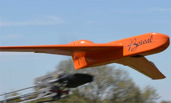
EGNSS improves positioning integrity and accuracy for the Boreal drone. (Photo: GSA)
News from the European GNSS Agency
The Skyopener project, co-financed by the European GNSS Agency (GSA), aims to pave the way toward increased use of remotely piloted aircraft system (RPAS) in civil applications.
The project has tested the benefits of multi-frequency GNSS and EGNOS in RPAS, revealing gains in availability, accuracy and robustness.
There is increasing demand to operate RPAS over long distances because of their potential for a wide range of civil applications. However, regulation regarding RPAS use in civil airspace does not yet allow beyond-visual-line-of-sight (BVLOS) operations, and remotely piloted aircraft are not allowed to fly in non-segregated civil airspace and are not yet widely used for civil and commercial applications.
This is something that Skyopener aims to change.
RPAS for civil applications. The project is developing operational processes that will reduce all categories of risks associated with RPAS and allow an air navigation service provider (ANSP) to manage very-low-level RPAS operations. Thanks to the benefits it offers in terms of improved integrity and positioning accuracy, EGNSS (Galileo and EGNOS) will play a central role in these processes.
Through these operational processes, Skyopener will contribute to the roadmap for the integration of civil RPAS into non-segregated airspace, which will have a huge impact on the service applications that can be offered by these aircraft.
“Systems that enable RPAS to fly safely, in compliance with regulations, will enable market access and significantly reduce the cost of insurance premiums for RPAS operators, making a wide range of RPAS applications more commercially attractive and widely used,” said Marc Pollina, CEO of Skyopener consortium member M3 Systems.
Excellent results. A test conducted by the project into the benefits of multi-frequency GNSS and EGNOS has delivered excellent results. The test found that the use of GPS and Galileo in L1/E1 and L5/E5 multi-frequency combinations provides improved availability, better accuracy and greater robustness against interference, as interference with one frequency band has no effect on the second.
What’s more, EGNOS helps meet increasingly stringent requirements for robust navigation, continuity, accuracy and availability — further complemented by Galileo’s multi-constellation capacity and integration with other sensors such as inertial or vision sensors.
The Boreal drone used in the project is a fixed-wing system that operates over a long range (more than 100 kilometers) in BVLOS, with EGNOS and Galileo enhancing navigation by improving positioning integrity and accuracy. In addition, the RPAS is equipped with a newly developed communication and navigation surveillance (CNS) system that combines use of GNSS, satcom and special security measures.
Essential GNSS. GNSS technologies are essential for RPAS. The primary need is obviously for navigation — the RPAS uses GNSS waypoints to follow the trajectory defined in its mission. However, GNSS also addresses other key needs, such as geofencing to ensure that the RPAS keeps within the mission parameters and surveillance to enable adequate tracking by the operator and civil aviation authority.
GNSS also enables high accuracy and, ultimately, automated landing and the geo-referencing of collected data. These benefits will increase in the future, with the Galileo authentication service reducing the risk of threats, and PPP data correction on E6 providing better geo-referencing.
By Juan Vázquez, Elisabet Lacarra, Jorge Morán and Miguel A. Sánchez, ESSP SAS, and Julian Rioja and Jimmy Bruzual, Topcon Agriculture
The European Geostationary Navigation Overlay Service (EGNOS), a satellite-based augmentation system (SBAS), provides corrections and integrity information to GPS signals over Europe and is fully interoperable with other SBAS such as North America’s WAAS. Among its services is the internet-based EGNOS Data Access Service (EDAS).
EDAS gathers raw data from GPS, GLONASS and EGNOS GEO satellites collected by receivers at approximately 40 EGNOS ground stations distributed over Europe and North Africa. EDAS reformats and disseminates GNSS data in real time and through an FTP archive to EDAS users and service providers.
Additionally, EDAS provides differential GNSS corrections to the GPS and GLONASS satellites in view by the EGNOS system network through its Ntrip service.
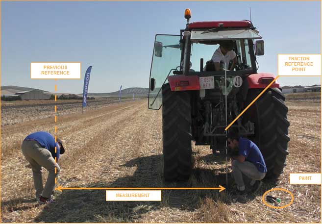
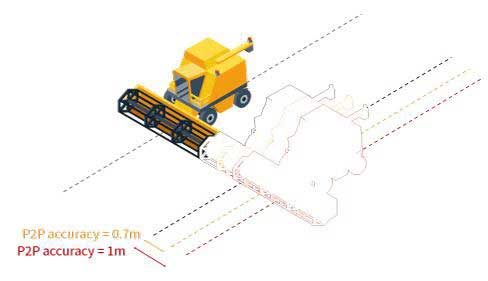
The tests summarized in this article focused on the EDAS Ntrip Service, which can be used for differential positioning. An earlier test near Seville, Spain, concluded that these corrections could support pass-to-pass accuracies in the order of 20 centimeters in a consistent manner and with a high degree of repeatability.
To assess EDAS performance validity for agriculture applications, two additional tests were done in Lisbon, Portugal, and York, UK. These locations provide diversity with respect to the Seville test, especially in terms of distance from the farm to the selected EGNOS reference station (≈320 km in York and 40 km in Lisbon, versus the 110 km baseline of the test in Seville) and also geographically. In all tests, a real-time kinematic solution operated in parallel to the EDAS DGPS solution to provide the required reference for the post-processing of the recorded data. Nine different runs with a total of 78 passes were performed in these two campaigns.
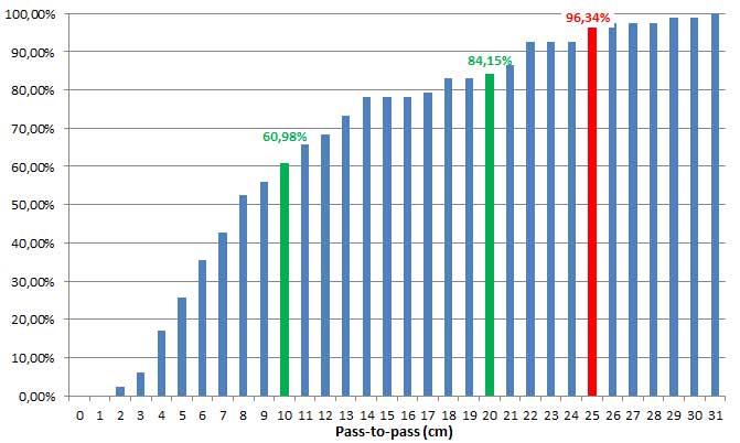
Considering the results from the three tests, the pass-to-pass accuracy supported by EDAS DGPS corrections was below 10 cm for more than 60% of passes and below 20 cm for more than 85 percent of the passes. These figures exceed the earlier results and confirm that EDAS DGPS corrections can deliver pass-to-pass accuracies in the order of 10 to 20 cm in a consistent manner.
Cumulative distribution of P2P accuracy, in centimeters. (Chart: Topcon)
The stability of the results and the very good pass-to-pass accuracy levels observed in the York scenario, where baselines larger than 300 km were tested, deserve highlighting. For grain and dry soil cultivation, at least 1 meter (95th percentile) of absolute horizontal accuracy is required. It can be assumed that, within the area where EDAS DGPS supports sub-meter horizontal accuracies (up to 260 km from the selected EGNOS station, according to previous studies), EDAS DGPS corrections can also support pass-to-pass accuracies in the order of 10-20 cm.
Such performance levels are considered to be appropriate for most grain farm operations. In particular, the observed performance is sufficient to support the following precision agriculture applications:
Space Based Augmentation Systems (SBAS) – known in North America as the Federal Aviation Administration’s (FAA’s) Wide Area Augmentation System (WAAS) – have been fully operational in one form or another for several years. The FAA’s incremental improvements to integrity, accuracy and reliability in WAAS have brought the system to a point where we have precision en-route navigation for aircraft, and we can also land aircraft using WAAS signals at thousands of airports in the US and in Canada.
Why not Mexico, which also benefits from the same WAAS coverage? More on that later, as we piece together the many parts of the complex SBAS mosaic.
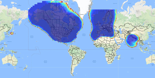
SBAS precision approach coverage, May 2016. Graphic: FAA Tech Center, Lockheed Martin, GMV
Europe benefits from high-accuracy en-route navigation, and there are also hundreds of operational approaches using the European Geostationary Navigation Overlay Service (EGNOS) SBAS.
In India, the GPS Aided Geo-Augmented Navigation (GAGAN) system provides accurate en-route navigation and approach capability. However, ionospheric disturbance may limit some aspects of performance.
Japan established the Multi-functional Satellite Augmentation System (MSAS) SBAS, and has benefited from improved en-route navigation, but it’s possible that the more limited geographic distribution of GPS ground reference stations has restricted improvements to approach capabilities.
But what happened to the International Civil Aviation Organization (ICAO) concept from 2007, supported by all the ‘aviation-going’ countries of the world, that SBAS would evolve and eventually multiple national systems would provide coverage around the rest of the world, maybe even by 2016?
Countries in Asia, South America, Africa and the continent of Australia all appear to have looked closely into establishing their own SBAS, but nothing seems to have come out of these investigations. Technical issues, cost, and political obstacles have all hindered global SBAS progress.
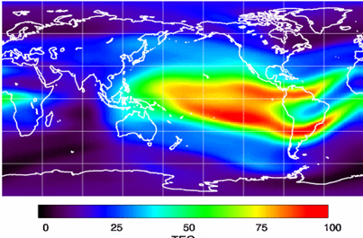
The ionospheric challenge. Graphic: GMV and Lockheed-Martin
Technical Issues. Ionospheric scintillation problems around the Equator seem to be at the root of most technical problems for SBAS. Getting to the required level of probable, bounded system error is hugely difficult. The iono disturbance ‘blob’ follows the sun around the Equator and wipes out any chance of satisfactory system performance when it passes over Equatorial countries.
As total electron count (TEC) increases, the ionospheric grid, which most SBAS use to predict ionospheric variation across their geographic area between fixed reference stations, well, it just doesn’t work anymore.
Cost. The capital cost of building a satellite-based augmentation system and the on-going cost of maintaining a bunch of geographically distributed reference sites, building and launching GEO satellites or renting transponders on someone else’s orbiting asset, establishing, operating and maintaining redundant uplink stations, redundant terrestrial data links, and setting up control systems that collect and create the SBAS uplink message — it all adds up. Millions and maybe even billions of dollars or equivalent, in total, have been spent by those select countries who could afford their own SBAS. Others named above have lesser financial resources upon which to draw.
Political Obstacles. One of the trickiest issues is sovereignty: the need for a country to control its own navigation and landing system. This has likely been the source of most resistance to more SBAS systems being set up and shared by bordering countries around the world.
For a large number of smaller countries, SBAS would only make sense if it was shared across a number of neighboring countries, but that means relinquishing sovereignty to some degree. In several regions of the world a number of geographically adjacent countries don’t particularly like each other, never mind thinking of such sharing/collaboration.
National sovereignty, by the way, isone of the main reasons that existing satellite navigation systems underpinning SBAS, such as Galileo, GLONASS, IRNSS (now NAVIC), QZSS and of course BeiDou have all been put in place.
Another problem with potential SBAS sharing across adjacent countries stems from responsibility for liability. Should something not work and an accident ensues from such a malfunction, who’s liable? Mexico seems to have adopted the view that since the US provides WAAS on what could be called an ‘as-is’ basis, then the potential liability issue seems to trump using the system.
Solutions? Technical issues with the ionosphere may soon be resolved by using dual-frequency L1/L5 airborne receivers that directly calculate their own ionospheric corrections, rather than using the computed SBAS iono grid. If we add in dual-frequency E1/E5a signals from Galileo, things start to get even better. New requirements and prototype equipment are already being developed for dual frequency multi-constellation airborne receivers. Airbus anticipates equipping aircraft with such receivers around 2025. Could this solve the SBAS technical issue for Equatorial countries?
ARINC (now a UTC/Rockwell Collins company) and SITA (in Europe) have been providing commercial aircraft with operational communications services on a pay-for-use basis for a number of years, and this is notarized as an accepted means of compliance within ICAO policy/requirements:
From ICAO Doc. 9161, Sec. 3.99: “A group of states or a regional organization might also undertake to operate the augmentation satellite service required, either by themselves or by contracting a commercial or government organization to do so on their behalf.”
ARINC en-route coverage. Graphic: ARINC
Aireon has partnered with NAV CANADA, the Irish Aviation Authority (IAA), Enav, NATS and Naviair, as well as Iridium Communications and Harris Corporation to provide real time ADS-B data (GPS position output from aircraft) to air-traffic control providers. Aireon’s payloads on the new Iridium NEXT Low-Earth Orbit (LEO) satellite constellation will receive aircraft ADS-B messages and relay them to Air Traffic Controllers in real-time.
There are 66 Iridium NEXT satellites in operation, with significant overlap and redundancy built into the system to enable this safety-of-life service to be provided on a pay-for-use basis to the aviation industry. We could at last know the location of every suitably equipped aircraft in the air, in almost real-time. The ICAO requirement is for an update rate of 15 minutes.
Inmarsat ADS-C is a similar service available to aircraft on a contracted, pay-for-use basis via Inmarsat GEO satellites.
Market Solutions. If a substantial company showed up with a worldwide distributed SBAS solution and offered it on a fee for service basis, why wouldn’t countries that are already accustomed to ARINC and SITA pay-for-use communications? The Aireon international aircraft tracking system, to be provided on the same basis, adds to the credibility of such a pay-for-use service.
So why wouldn’t these accepted services demonstrate to those countries concerned about control and national sovereignty that an SBAS service could be provided on this basis?
The liability for provision of service sits with the providers, so user countries/airlines would have someone to turn to about liability issues, and there presumably could be contract terms to provide system performance guarantees.
No huge capital costs, no system to construct, nor staff to operate or maintain, and yet a level of control similar to that which has been around for commercial aircraft communications for decades.
Would this be of interest to countries that have not yet jumped on the SBAS bandwagon? A definite ‘maybe,’ we could imagine? What’s not to like?
The punch line to all this is that Lockheed Martin and GMV (Spain) have teamed to challenge these non-SBAS countries with a solution which may appeal.
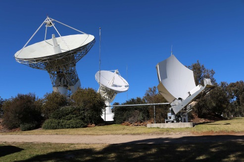
Uralla reference test site. Photo: Lockheed-Martin
To present convincing evidence that it would work, a dual frequency GPS (L1/L2) + Galileo (E1/E5a) reference site has been set up in collaboration with Geoscience Australia and Land Information New Zealand. The reference site is located at Uralla, New South Wales on Australia’s East Coast, where it gathers data demonstrating bounded errors within the operational range which could enable GNSS approach capability.
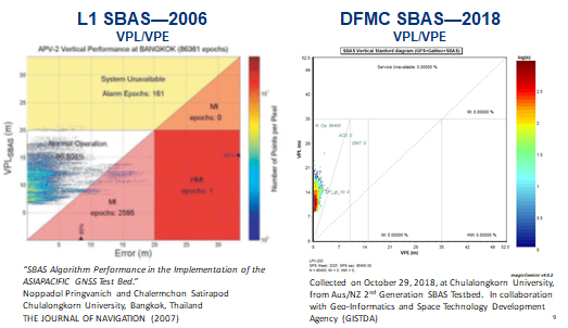
L1 (2006) vs. DFMC (2018) SBAS at Bangkok. Graphic: Lockheed-Martin, GMV
Another test site in Bangkok, Thailand has demonstrated that existing L1-only SBAS in this area cannot manage this performance (all current SBAS are L1 only), but that with dual-frequency multi-constellation (DFMC) GPS L1/L2+Galileo E1/E5a, the required performance limits could be met.
Lockheed Martin has also been using the Uralla uplink site to test the uplink and downlink of dual-frequency SBAS-like test messages.
The Moral of the Story. There are no miracles as yet, but interest in the pay-as-you-go SBAS concept appears to be growing, and the LM/GMV team continues to work to bring their approach to market.
A large number of countries could well benefit from the high accuracy, integrity and continuity of SBAS service if this all comes together.
If you’ve taken a flight in Europe recently, then the chances are growing that you’ve been a pioneer EGNOS user. Satellites in orbit would have guided your airliner’s descent, rather than signals beamed from the ground. You wouldn’t have felt any difference — except for possibly a smoother ride.
Cockpit of a new EGNOS-equipped Airbus 350 XWB, on show during the inaugural EGNOS Day at Toulouse-Blagnac Airport on May 7, 2015. (Photo: ESA)
More than 180 European airports have now been certified to make use of the ESA-designed European Geostationary Navigation Overlay Service — EGNOS — for approaches to given runways. This includes approaches at major hubs such as Paris Charles de Gaulle, Frankfurt and Amsterdam Schiphol. Thanks to EGNOS, safe landings would still be possible even if an airport were shut down entirely.
Sharpening the precision of GPS satnav signals over most European territory, EGNOS was designed to make satnav reliable enough for safety-critical aviation employment, but has found a wide range of other uses, from agriculture to road, rail and maritime transport.
An EGNOS app is available from the Apple and Google Play stores, offering easy access to all EGNOS-related information, including the different EGNOS services, official documentation, historical and current performance data, support material and contact with the 24/7 EGNOS helpdesk.
An EGNOS V3 Ranging and Integrity Monitoring Station (RAIMS) being tested at the Santiago de Compostella site in Spain, designed and manufactured by Thales Alenia Space in Italy. (Photo: ESA)
EGNOS is based on a network of monitoring stations across Europe that perform independent measurements of GPS signals, so that corrections can be calculated to boost satnav positioning performance. These results are passed to users immediately via a trio of geostationary satellites.
The service is allowed just a one in 10 million chance of error. If this tolerance is exceeded, EGNOS users are informed within six seconds. The result is that EGNOS-augmented signals meet the extremely high performance standards set out by the International Civil Aviation Authority, adapted for Europe by Eurocontrol, the European Organisation for the Safety of Air Navigation.
EGNOS operations are the responsibility of the European Global Navigation Satellite System Agency (GSA) of the European Commission and run by the ESSP, European Satellite Services Provider.
EGNOS is the European equivalent of the U.S. Wide Area Augmentation System (WAAS), which was the world’s first satellite-based augmentation system. The U.S. and European systems have been carefully designed to work together seamlessly.
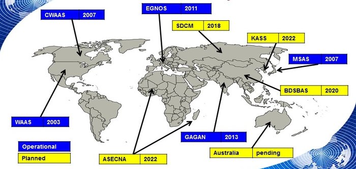
Additional equivalent regional systems, fully interoperable with the existing ones are either in operation (Japan, India, Canada) or in definition or development (Russia, China, South Korea, West Africa and Australia).
Satellite-based augmentation systems worldwide. (Image: ESA)
Through the LPV-200 procedure, short for “localizer performance with vertical guidance 200 feet,” signals from space guide pilots through any weather down to within just 60 meters (200 feet) of the runway, at which point they make visual contact with the ground for a final go/no go landing decision.
EGNOS offers all-weather access to all certified runway approaches — each side of a runway requiring its own, separate, certification — without the need for expensive ground Instrument Landing System infrastructure. Satellite-based landing approaches can also be tailored to be smoother and more fuel-efficient.
Smaller airports unable to afford ground instrumentation draw the greatest benefit. Employing EGNOS means they get to operate in all weather conditions.
ESA retains the lead role in the future development of EGNOS, working with Thales Alenia Space and Airbus Defence and Space and their subcontractors to design, develop, deploy, and validate and test the new design elements.
While the current system is solely reliant on GPS, the next-generation EGNOS V3 will combine the use of GPS with Europe’s own Galileo satnav system to boost EGNOS accuracy and reliability still further. It is planned to enter service around 2025.
Precision agriculture depends on the precise positioning of augmented GNSS. In Europe, this augmentation is provided by the European Geostationary Navigation Overlay Service (EGNOS).
Although EGNOS is widely available in Europe, coverage is lacking in remote and rural areas.
To help fill the needs of farms in these areas, the Horizon 2020 AUDITOR project, funded by the European GNSS Agency (GSA), is developing a ground-based GNSS augmentation system that will deliver high-performance and cost-efficient services and applications for the agriculture industry.
“The purpose of this project is to develop an improved GNSS ground-based augmentation system using modern and proven algorithms in highly configurable, cost-effect receivers,” said Project Coordinator Esther Lopez. “As a result, AUDITOR will enable cost-effective precision agriculture services for farmers, especially those with small and mid-sized farms in areas where EGNOS availability is limited.”
The AUDITOR system is based on a radio frequency (RF) dual-band multi-constellation GNSS front-end and an embedded digital processing platform. The front-end receiver acquires the GNSS signals and embeds all analog and digital hardware required to convert the RF signal to digital samples.
The digital processing platform then converts and customizes the signals for the AUDITOR systems. The system serves as the basis for providing higher level services for the end user via cloud-based web and mobile applications.
Autonomous Future. With AUDITOR applications, farmers will be able to accurately measure spatial variability in soils and crops. Yield maps will allow farmers to precisely apply fertilizer, water and pesticides, reducing production costs and environmental impact.
AUDITOR’s high-accuracy positioning will also enable the use of autonomous mobile robotic units for identifying weeds, pests and diseases, GSA said.
“Producing precise maps of the soil and crops, as well as the spatially varying application of fertilizer that these maps enable, is completely dependent on the availability of an augmented GNSS signal,” Lopez said. “Thanks to AUDITOR, even areas in Eastern and Southern Europe that once were unable to get the required precise GNSS signal can reap the benefits of precision agriculture.”
With the ever-increasing requirement for augmented yield and profitability and energy and cost savings, the future of farming is precision agriculture. By focusing on providing the augmentation needed to enable existing precision agriculture applications in Europe alone, Lopez is confident that AUDITOR will be well-positioned to compete on the market.
The European GNSS Agency (GSA) has issued a request for information (RFI) in preparation for the procurement of EGNOS geostationary navigation payload services.
The EGNOS space segment is provided by commercial satellite operators on the basis of service contracts. The GEO-1, GEO-2 and GEO-3 service contracts now cover the EGNOS space segment needs, and the GEO-1 and GEO-2 services will be the first of these to end, GSA reported. The GEO-1 and GEO-2 services will be replaced by new contracts, GEO-4 and GEO-5.
GSA is planning how it will replace the services delivered by the GEO-1 and GEO-2 satellites, and it’s issuing the RFI to collect information about opportunities to embark navigation payloads on board GEO satellites launched in a suitable time frame.
According to GSA, the results of the RFI will also be used to determine the best approach for the procurement of the payload services, which may be either procured at the same time or separately. It will help GSA define the tender specifications and decide on the most appropriate time to launch invitations to tender.
In addition, GSA aims to obtain information from owners of geostationary satellites that will be available for operational service from 2021 to 2027 and able to embark a navigation payload. The agency is specifically seeking information on future satellite plans and the possibility to embark SBAS payloads in due time to ensure an operational start date from 2021 to 2027.
The RFI will also request information service availability and long-term payload reliability; the process for EGNOS payload procurement, in-orbit testing and commissioning; information on the locations of the potential hosting sites for the EGNOS radio frequency uplink stations; and, finally, information on contractual arrangements, the payment scheme, and cost estimates, GSA added.
Answers to the RFI should be sent electronically to [email protected] by Aug. 31.
Spirent Communications plc is working with the European Commission’s Joint Research Centre (JRC) to help implement the eCall system, which is required in new cars sold in Europe starting in April.
Experts from the JRC have been working with Spirent GNSS test equipment during the European GNSS Agency (GSA) eCall test campaign. The campaign aims to pre-test eCall in-vehicle modules and evaluate their compatibility with the positioning services provided by Galileo and the European Geostationary Navigation Overlay Service (EGNOS) in accordance with the test procedures established by the regulation.
As the eCall initiative goes live this month, the GSA launched a test initiative to support eCall device manufacturers in their preparation for type approval. In safety-critical situations, eCall must be as accurate as possible, so defining and conducting proper test procedures is imperative.
Spirent is cooperating with the JRC to develop its own eCall test solution. “Working with JRC enabled us to develop better tests to verify that eCall devices are working properly,” said Steve Hickling, product director for Spirent’s positioning business.
When a collision occurs, an eCall-equipped car automatically calls the nearest emergency centre. Even if no passenger is able to speak – such as because of injuries — a “minimum set of data” is sent, which includes the exact location of the crash site. eCall is expected to significantly reduce emergency service response times, leading to lives saved and injuries reduced.
The JRC used a Spirent GSS9000 simulator to assess eCall devices’s capability to support the reception and processing of the Galileo and EGNOS signals. Using feedback from the JRC, Spirent has developed an eCall Test Suite for its automation solution, PT TestBench.
Tested with various eCall devices, the eCall Test Suite is available for eCall device manufacturers and include, among others, positioning accuracy, time to first fix, GNSS receiver sensitivity and reacquisition performance.