Jack Dangermond, co-founder and president of geographic information system (GIS) giant Esri, told his customers on March 10 that he is “shocked and distressed by the grim circumstances in Ukraine.” Consequently, he announced, Esri and its distributor Esri CIS have stopped all their sales to Russia and Belarus. The company is also supporting several organizations across Europe “in their humanitarian and military efforts in support of the Ukrainian government and its people.”
“The invasion of Ukraine is a devastating chapter in our history,” Dangermond continued. “We have heard from so many members of our GIS community who, like us, stand with the Ukrainian people. Make no mistake, this is a daunting moment that will demand strength, compassion, and resolve from all of us.”
125+ speakers and 50+ sessions are confirmed for the 2022 edition of Geo Week in Denver
Organizers of Geo Week, which brings together geospatial technologies and the built world, have announced its conference sessions and speakers for the 2022 event, which will take place Feb. 6-8 in Denver, Colorado.
The conference program features more than 125 speakers across 50 sessions with content that explores best practices in 3D capture, working in the built environment, gaining return on investment (ROI) from building information management (BIM), defining what’s possible now with lidar, and more.
The coming together of AEC Next Technology Expo & Conference, International Lidar Mapping Forum, and SPAR 3D Expo & Conference to form Geo Week reflects the increased integration between the built environment, advanced airborne/terrestrial technologies, and commercial 3D technologies.
Presenters represent Autodesk, Esri, USGS, The Beck Group, Hexagon Geosystems, GM, Caltrans, Velodyne Lidar, Draper, MLB and NASA. These experts will share their expertise on a range of topics. Sessions include:
Geo Week will have multiple tracks with content clearly identified as relevant to one or more of the audience groups feeding into Geo Week.
The International Lidar Mapping Forum (ILMF) audience has historically been comprised of precision measurement professionals in surveying and mapping who use airborne and terrestrial lidar and related remote sensing technologies.
The AEC Next audience has historically been comprised of professionals in architecture, engineering and construction that use technologies such as reality capture, automation, artificial intelligence and XR to bid and manage projects and improve workflows.
The SPAR 3D audience has historically been comprised of professionals who use 3D capture, scanning, visualization and modeling technologies across a variety of verticals.
“We’ve witnessed the growing convergence between geospatial and the built world,” said Lee Corkhill, group event director at Diversified Communications, organizer of Geo Week. “We believe the market is ready and eager for this next step of leveraging the confluence of technologies for improved collaboration, increased efficiency, and better outcomes. Much of the conference content and technology being showcased will reflect and support this increasing integration. At the same time, we recognize that individuals and organizations are at differing levels of adoption, and so there will be ample content more focused on what were traditional AEC Next, ILMF and SPAR 3D topics.”
Geo Week will provide education, technology and resources for professionals in industries including AEC, asset and facility management, disaster and emergency response, Earth observation and satellite applications, energy and utilities, infrastructure and transportation, land and natural resource management, mining and aggregates, surveying and mapping, and urban planning and smart cities.
More than 80 companies have confirmed booths on the Exhibition Floor with additional companies being confirmed every week and more than 100 associations and media companies are signed on as supporters.
Geo Week takes place Feb. 6-8, 2022, with conference programming and exhibits all three days. Additional features of the programming are vendor-delivered product reviews, exhibition theaters, workshops and programming hosted by ASPRS, MAPPS and USIBD. Visit www.geo-week.com for more information on attending or exhibiting. Register before Dec, 10 for early bird rates.
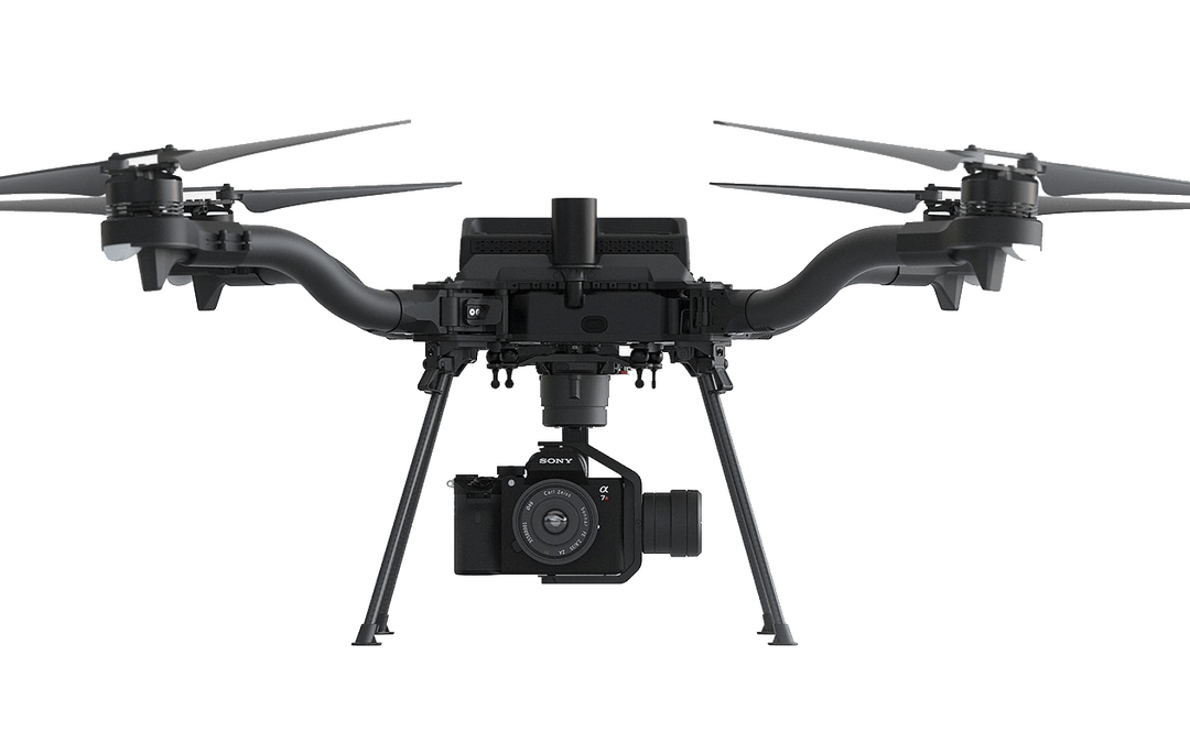
A new vertical-takeoff-and-landing (VTOL) drone — the WingtraOne GEN II — is now available. The GEN II offers industrial reliability and mapping versatility with an oblique camera configuration for high-quality 3D drone-mapping data capture.
Drone maker Wingtra spent six years developing the GEN II, and tested it over 100,000 flights. Its WingtraOne is being used by professionals worldwide across many industries.
According to Wingtra, the GEN II represents a solid step forward in industrialization and reliability along with new perks that push the previous limits of commercial mapping drones.
The WingtraOne GEN II. (Photo: Wingtra)
Oblique 3D Mapping Payload
“We wanted to make the WingtraOne drone even more versatile for our customers. So next to our flagship 42MP Sony RX1, we’re including new, high-end mapping payloads,” said Maximilian Boosfeld, co-founder and CEO of Wingtra. “I’m especially excited to announce our oblique solution, which offers outstanding 3D mapping results. It’s the perfect choice for capturing infrastructure — from a single industrial plant to entire cities.”
WingtraOne’s GEN II oblique mapping solution is backed by signed partnership agreements with Bentley Systems and Esri. To demonstrate the power of GEN II carrying its Oblique Sony A6100 payload, the Wingtra team mapped the city of Zurich, Switzerland, in six flight hours, producing a 3D model processed with both Bentley ContextCapture and Esri’s Site Scan for ArcGIS. Bentley and Esri’s software are both recommended for processing Wingtra oblique datasets.
“Bentley Systems is delighted to partner with Wingtra to transform high-resolution oblique imagery from WingtraOne drones into 3D reality meshes — an ideal starting point for infrastructure digital twins,” said Phil Christensen, VP, Industry Solutions, iTwin Context, Bentley Systems. “This enables our common users to perform analytics on the resulting models as well as leverage Bentley’s iTwin platform to share performant, city-scale digital twins.”
“Our partnership with Wingtra unlocks new capabilities for Site Scan for ArcGIS users by allowing them to create wide-scale and accurate 3D meshes leveraging the oblique payload on the WingtraOne Gen II,” said Richard Cooke, director of Global Business Development at Esri. “These high-resolution images processed through Site Scan produce an enriched 3D GIS for our users who require modelling of open-pit mines, accurate construction updates, creation of digital twins for cities, and more.”
The WingtraOne GEN II drone was used to map Zurich and create a digital twin of the city. (Image: Wingtra)
Integrated PPK and Self-Diagnosis
WingtraOne GEN II features post-processed kinematic (PPK) ability integrated on every drone, including multispectral Altum and RedEdge payloads, as well as advanced fail-safe and self-diagnosis algorithms and services for dependable operations.
“We have studied over 100,000 flights and all incoming customer reports to understand what the limits might be so we can push them further,” said Julian Surber, Wingtra product manager. “As a result, we’ve designed many reliability tools for GEN II to guarantee uninterrupted operations.”
Wingtra’s engineering team has redesigned the electronics of the GEN II from its predecessor WingtraOne for increased reliability, including a more powerful onboard computer, optimized PCB designs, and a new navigation and heading unit developed inhouse.
The GEN II runs through health-monitoring algorithms for motors, servos, batteries, camera, PPK and onboard sensors, health self checks that minimize the potential of flight with unsafe equipment.
Precision Agriculture Boost
Wingtra’s top-of-the-line multispectral payloads Micasense Altum and RedEdge will now be paired with high-accuracy PPK, which improves the quality of multispectral insights for uses such as irrigation management and prescription maps for pesticides.
In the latest edition of this classroom textbook, Getting to Know ArcGIS Desktop 10.8 guides students and professionals through the fundamentals of making maps and analyzing data using the latest Esri ArcGIS Desktop software.
The comprehensive, hands-on tutorial, moves readers from basic GIS concepts to sophisticated GIS analysis. Readers gain practical knowledge about ArcGIS Desktop tools and functionality. Exercises address querying map data, making map layouts, symbolizing and labeling maps, setting map projections, creating and sharing web maps, building and editing geodatabases, and analyzing geospatial data.
Data for completing the exercises and a 180-day free trial of ArcGIS are also available for download.
Esri is offering two major capabilities in Site Scan for ArcGIS that will enable governments and critical infrastructure organizations to meet hardware and software regulations in the United States and Europe. Site Scan is Esri’s unmanned aerial systems flight planning and processing solution.
Through an established partnership with Auterion, creator of an open-source drone autopilot operating system, security-conscious U.S. organizations will be able to use Site Scan to plan and execute missions with Auterion’s Freefly Astro drone.
In Europe, data from publicly funded or critical infrastructure projects cannot leave the European Union (EU). For these organizations, a new and fully independent instance of Site Scan for ArcGIS has been deployed to a server cluster in Ireland, ensuring that organizational data resides within the region.
Site Scan for ArcGIS is used by organizations that require drone imagery for visual inspections, site monitoring, asset management and situational awareness. It’s an all-in-one, cloud-based drone mapping solution for managing fleets and collecting, processing, analyzing, and sharing data products. Industries using this solution include architecture, engineering, construction, natural resources, infrastructure and government.
Freefly Astro uses U.S. Department of Defense-approved Blue sUAS software architecture from Auterion, and is fully supported by Site Scan. The first vehicle integrates the software with the Freefly Astro, with more vehicles becoming available.
Auterion’s secure, integrated workflow for mapping uses the Freefly Astro drone, Sony A7R4 camera and Esri Site Scan within a single platform.
The Freefly Astro and Site Scan integration will be available by December. The European deployment of Site Scan is available now.
Esri has released a new mapping app, Air Quality Aware, that fuses data from the EPA’s AirNow program, NOAA’s National Weather Service wind forecast and the American Community Survey to provide location intelligence on current air quality and its impacts on local communities.
At a national level, areas are color-coded according to EPA’s Air Quality Index, with magenta and purple representing hazardous and very unhealthy air quality.
As users zoom in, the map shows the air-quality scores reported at each individual air-quality monitoring station.
Users can click on any station for more information about the pollutants and concentrations reported at that location. They can also search for or click any place on the map to get more information about current and forecasts of air quality, wind speed and insights about the vulnerable population in each place.
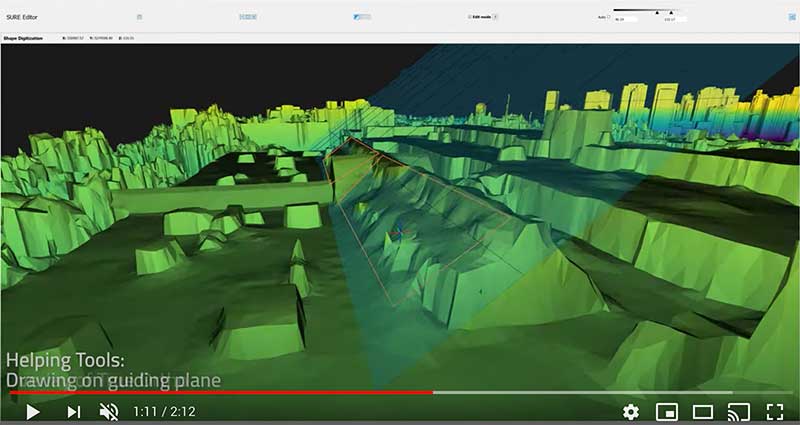
Esri has acquired nFrames, a technology company that develops SURE, an imagery and lidar 3D surface reconstruction software.
According to Esri, this will enable the fusion of imagery with 3D GIS, allowing nFrames and Esri users to seamlessly capture and analyze 3D data from aerial, drone and ground-based sensors in an automated end-to-end process.
SURE scales 3D data creation to large city and countrywide airborne image datasets and projects. According to nFrames, it gives professional photogrammetry workflows improved precision, speed and simplicity on premises or in the cloud. SURE can be used for a number of industries, including those in government; national mapping; insurance; and architecture, engineering, and construction (AEC).
Through this acquisition, Esri gains a robust production engine that transforms imagery and lidar data into point clouds, phototextured 3D meshes and true orthos, Esri said.
SURE software editor (Screenshot: nFrames)
In addition, SURE allows its users to generate 3D maps at scales from individual construction sites to entire cities and countries. These maps are fully automated at high resolution and repetition rates, nFrames added.
“nFrames is a leading provider of 3D image reconstruction software and services, and I am excited to welcome the company to the Esri family,” said Jack Dangermond, Esri founder and president. “As Esri continues down its path of innovation to create a multidimensional experience, this acquisition enhances our ability to create extremely high-quality 3D data from imagery, which is critical for our customers in the municipal, planning and AEC industries.”
SURE software will become a part of Esri’s ArcGIS platform. According to Esri, it will make SURE capabilities available in ArcGIS Drone2Map and Site Scan for ArcGIS so users can create better meshes, point clouds and true orthos from their drone imagery.
“Together with Esri, we will be able to unlock the full value of 3D surface data through GIS by connecting geometry with metainformation to provide spatial context,” said Konrad Wenzel, CEO and co-founder of nFrames. “This fully automatic chain from data capture to analytics will enable smarter decision-making.”
The nFrames headquarters will now serve as a new Esri research and development center based in Stuttgart, Germany.
According to the association, the interactive mapping-based app shows how jurisdictions have taken actions to reopen certain business sectors by issuing statewide orders. It also shows how jurisdictions are undertaking regional-based approaches or implementing statewide orders with authorization for localities to place additional restrictions.
The map also allows users to explore public health actions governors have taken during the pandemic, including statewide stay-at-home orders, limits on gatherings, state employee travel restrictions, quarantine orders for interstate travel and more.
The map, which is updated on a daily basis, features data collected from states and territories. The data is based on an evaluation of state executive orders, directives, guidance, legal and non-legal documents, and news sources, the National Governors Association said.
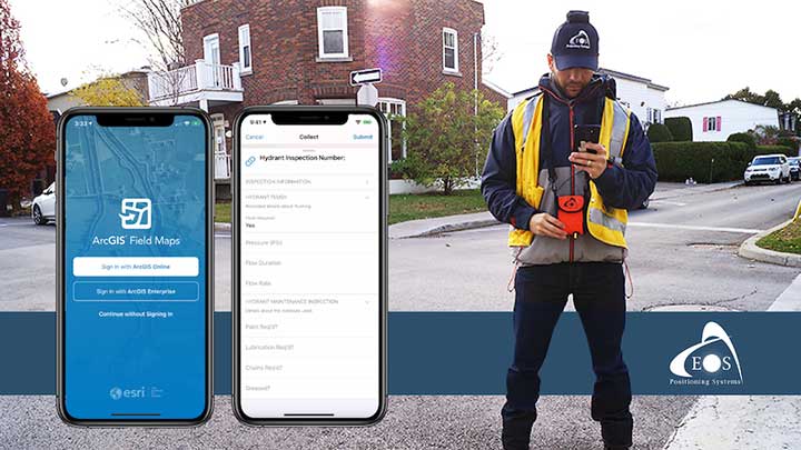
A new Esri mobile app, ArcGIS Field Maps, will be released in its first beta in July, with the final version expected to be released in September.
According to Esri, Field Maps will combine the following capabilities into a single app:
Simple map viewing and markup
High-accuracy field data collection and inspection
Battery-optimized location tracking
Work planning and task management
Turn-by-turn navigation
Field Maps also will include a new web app, integrated with ArcGIS, that can be used to configure and deploy maps optimized for your mobile workforce needs, create and assign tasks to mobile workers, and create and share views of worker locations.
Arrow support included
The inaugural beta includes support for Arrow GNSS receivers’ high-accuracy locations, elevations and metadata, according to Eos Positioning.
ArcGIS Field Maps will provide the combined functionality of five Esri mobile apps: ArcGIS Collector, ArcGIS Explorer, ArcGIS Tracker, ArcGIS Workforce and ArcGIS Navigator.
In the first beta version, users will be able to perform markups, work with read-only maps, and work with MMPKs, including high-accuracy GPS locations and metadata from Arrow GNSS receivers.
Photo: Eos Positioning
Customers who have been wanting to take advantage of high-accuracy GNSS data in apps such as Explorer and Tracker will now be able to with the beta release. Customers who would like to have field crews able to access read-only maps with high-accuracy, for instance (such as during utility locates), this is now a possibility. In addition, crews can take advantage of high-accuracy GPS tracks while tracking.
ArcGIS Field Maps will also support the two formerly Collector-exclusive Eos solutions Eos Locate and Eos Laser Mapping.
Eos Locate. This high-accuracy underground mapping solution will be available in ArcGIS Field Maps right away in the first beta release. A single fieldworker will be able to perform real-time, high-accuracy mapping of underground assets using the same workflow he or she had previously used with Collector and Arrow GNSS.
Eos Laser Mapping. Similarly, laser offsets with Arrow GNSS receivers and LTI laser rangefinders will be available in the first beta of ArcGIS Field Maps. Learn more about laser offsets, including the three workflows for using them, here:
“We are incredibly excited for the new opportunities ArcGIS Field Maps brings to expand our partnership with Esri,” Eos CTO Jean-Yves Lauture said. “Now our joint customers will be able to use the Arrow GNSS receivers with Field Maps to access high-accuracy location when simply viewing and marking up maps and when logging location tracks.”
Eos Positioning told its customers, “We encourage all Eos customers currently using Collector, Tracker and/or Explorer to join the beta. Meanwhile, Collector, Tracker and Explorer are planned to continue working as usual, according to the roadmap Esri has outlined.”
Geospatial Solutions and GPS World are offering the latest news and updates concerning the coronavirus (COVID-19) pandemic as it affects the geospatial, mapping and GNSS/PNT industries. Read a message from GPS World here.
Esri will be providing a COVID-19 Response Package for free to all nonprofit organizations responding to the pandemic. According to Esri, this includes data, templates and solutions that are accessible through Esri’s Disaster Response Program.
By mapping data with capabilities such as spatial analysis, Esri’s software allows organizations to track where COVID-19 cases are spreading, and — through predictive modeling — determine where additional capacity will be needed. Using data visualization in maps and dashboards, nonprofits can see affected populations, share information with stakeholders virtually and measure the impact of their response efforts, Esri said.
“Esri enables us to identify vulnerable communities, whether they currently have unmet needs or appear to have a thin cushion with which to absorb a crisis,” said Raj Kamachee, Team Rubicon CTO and CIO. “Thanks to this wealth of location-based data, we have responded not only reactively, but have also been able to reach out proactively to these vulnerable communities, establishing a relationship during ‘blue skies’ so they have someone to call when disaster strikes.”
According to Esri, it has supported more than 10,000 nonprofits to advance their missions with geospatial data and tools through the Esri Nonprofit Program, which was launched in 2010.
“It’s never been more critical to ensure that nonprofits have the solutions that will enable them to target and serve vulnerable populations, understand disease spread, gauge their effectiveness and engage their communities,” said Jack Dangermond, Esri founder and president. “Our company was founded as a nonprofit, and so we share a deep commitment to the goals and mission that these organizations pursue.”
Founded in 1969, Esri provides geographic information system software, location intelligence, and mapping.
Over the last few weeks, many organizations have transitioned their workforce to remote work environments. At the same time, the demand for geographic information systems (GIS) products and skilled GIS professionals is high.
Esri announces that all of its instructor-led courses are available in its instructor-led online classroom, which is calls “an engaging learning environment that offers convenience and interactivity.”
The company lists these features:
Instructors and course attendees use the phone, chat, and virtual whiteboards to talk and collaborate in real time.
Group breakout sessions and content reviews support peer-to-peer learning and knowledge retention.
Attendees access all Esri software needed to complete course exercises through virtual machines.
“We understand that sustaining business operations and achieving your organization’s mission remains critical,” the Esri Training Team said in an email. “As always, we’re committed to helping you build the skills needed to apply ArcGIS best practices, fuel efficiencies and make the best decisions based on data.”
Esri offers the Esri Training Pass to streamline access to its online instructor-led classes. Users can pre-purchase training days to simplify training registration and approval processes throughout the year.