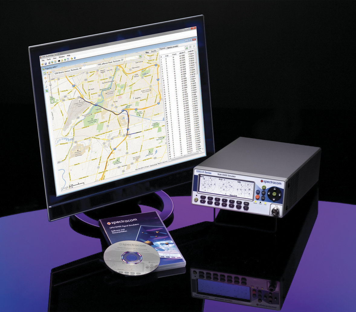
Orolia, through its Spectracom brand, has introduced built-in scenarios for testing eCall In Vehicle Systems compliance to the GNSS requirements of the regulation as an option with its latest Spectracom GSG simulator products.
In an initiative to bring life-saving rapid assistance to motorists involved in a collision, European Union (EU) regulation 2015/758 requires new vehicle types of M1 and N1 anywhere in the EU to be equipped with eCall in-vehicle systems as of March 31, 2018.
Spectracom’s GSG-6 Simulator with monitor.
In case of a crash, eCall systems automatically call the nearest emergency centre while sending the exact location, dramatically reducing response times. EU member states that do not comply will be refused EC type-approval for new types of motor vehicles.
Spectracom is providing options to ensure that automotive manufacturers who plan to continue selling into this market are equipped with the right tools for testing the eCall regulatory compliance of their equipment.
The Spectracom GSG line of GNSS simulators efficiently simulate all the major GNSS constellations needed for testing compliance of critical signal receiving equipment in a variety of eCall scenarios including:
Positioning accuracy under different conditions
Time-to-first-fix
GNSS receiver sensitivity
Re-acquisition performance following signal outages
Playing specific static and dynamic trajectory scenarios
Changing RF transmit power level manually or remotely sequenced as required by standard
“The eCall regulations require significant effort on the part of the auto industry to comply, and we are pleased to be including standard eCall scenarios as an option for our popular line of Spectracom GSG simulators,” said Lisa Perdue, GSG product manager at Spectracom. “We work in partnership with our automotive industry clients and will continue evolving the simulation product line to meet their needs for compliance testing with life-saving regulations.”
Spirent Communications’ testing systems are being used by the European Union TREASURE project (Training, REsearch and Applications network to Support the Ultimate Real-time high-accuracy EGNSS).
The aim of the four-year project is to provide instantaneous and high-accuracy positioning anywhere in the world, exploiting different satellite systems operating together to provide users with positional accuracy of a few centimeters.
Spirent’s GSS7000 test system.
By 2020 Galileo, the European GNSS system (EGNSS), will be fully operational and provide positioning data of unprecedented accuracy. Galileo’s integration with other satellite systems through the TREASURE project is key to increasing Europe’s competitiveness in the field, which has been mainly based on the GPS system in the past 20 years.
Higher accuracy services will not only assist safety-critical industries such as air and maritime navigation services, but also help industries such as the global agri-tech market, autonomous vehicles and capital-intensive sectors.
Kimon Voutsis, Robust PNT Solutions Architect, works on a professional services project for a client.
For example, more accurate real-time positioning data can assist farmers in maximizing food production, reducing costs and minimizing the environmental impact. Equally, a deep-sea drilling platform that experiences any temporary degradation in positioning accuracy could lead to significant financial losses.
“Spirent is proud to support multi-national initiatives that advance our industry and provide better end user performance,” said Martin Foulger, general manager of Spirent’s positioning business unit. “More systems are using GNSS data, and users always want better accuracy, so TREASURE will help to provide this.”
TREASURE is an EU-funded project under the H2020-Marie Skłodowska-Curie Innovative Training Network. It is coordinated by the University of Nottingham, and Spirent is the partner providing GNSS simulation systems.
For more information on Spirent’s GNSS testing solutions, visit the website. To learn more about how to test receivers of GPS, Galileo and other GNSS, download Spirent’s eBook.
To learn more about TREASURE, contact Marcio Aquino, Nottingham Geospatial Institute.
Participation of the United Kingdom space industry in Galileo may be in doubt as negotiations get underway on details of the U.K. withdrawal from the European Union (EU).
European Commission officials signaled that they want to rely solely on producers within the European Union for the block’s major programs, citing security concerns such as the possible acquisition of a U.K. contractor by a company from a non-EU country such as China.
In particular, officials are concerned about protecting the heavily encrypted, jam-resistant Public Regulated Service capability designed for government use that is reserved for EU member states and where U.K. industry has had a significant role.
Surrey Satellite Technology Ltd., based in Guildford, England, but a subsidiary of France-based Airbus, built 22 navigation payloads for Europe’s Galileo satellite fleet.
Other companies with U.K. interests that could be affected include Qinetiq, CGI, Airbus and Scisys.
Galileo SAR Service Launched
Galileo’s Search And Rescue (SAR) service became officially operational with a public launch on April 6, as part of the COSPAS-SARSAT network for detecting and locating emergency beacons activated by aircraft, ships and hikers. According to the European Commission, Galileo SAR will help reduce the detection delay of a distress signal from up to several hours to 10 minutes.
At sea, this makes SAR rescue operations easier thanks to a narrowed search box, since the vessel in distress has less time to drift. On land, acquisition of a precise position enables rescue teams to more quickly reach the operation zone and assist the victims. In the air, Galileo contributes to fulfilling International Civil Aviation Organization (ICAO) requirements for implementing the next-generation emergency management system Global Aeronautical Distress and Safety System (GADSS).
SAR transponders on Galileo satellites can pick up signals emitted from 406-MHz distress beacons anywhere in the service coverage area and transmit this information to the dedicated ground stations, the Medium-Earth Orbit Local User Terminals (MEOLUTs). The SAR/Galileo infrastructure is interoperable with GPS and GLONASS SAR transponders.
Once the beacon is located by the MEOLUTs, the location data is sent to the COSPAS-SARSAT mission control center, which distributes it to the relevant rescue centers. These then coordinate the required rescue efforts.
Galileo provides a ground segment coverage of 40 million square kilometers over Europe as a contribution to MEOSAR global coverage. Galileo SAR service is one of the three services launched in December 2016 with the Initial Services. The SAR service represented 1 percent of total Galileo program costs, but should result in thousands of lives being saved, said the European Commission.
Pile of Studies Produced Not a Lot
Headshot: Gen. Shelton
Testifying before a joint hearing of the House Homeland Security Committee and House Armed Services strategic forces subcommittee on March 29, Retired Gen. William Shelton, the former head of Air Force Space Command, warned that the U.S. needs to take action to protect GPS very soon.
He cited demonstrated ability by the Chinese government in 2007 to destroy a satellite in orbit, and improved signal jamming and cyber attack capabilities against ground control systems. The U.S. is unprepared to meet those threats, he said.
“Here we are 10 years later and we don’t really have a lot to show but a pile of studies,” Shelton said. “We’ve been part of this ‘one more study’ kind of attitude. ‘Well, that may not be the perfect answer, so let’s just do one more study’ and meanwhile time marches on. Satellites have fixed lifetimes, and you need to plan for the death of the satellite. A decision not to move forward is a de facto decision to maintain the status quo with no protection.”
Shelton stated that space research and development is at a 30-year low, with 15–40 percent of R&D funds taken by management services and technical assistance rather than actual research and development.
“The executive branch and the legislative branch could get together and agree on a strategy and a way forward and then execute … I don’t see any other way. There has to be some broad agreement here in the whole of government as we move forward.”
June Launch in japan for QZSS Michibiki 2
QZSS’s second satellite is scheduled for launch in June. Once completed, the Quasi-Zenith Satellite System will be a satellite augmentation system for GPS over Japan and other parts of the Pacific region.
Michibiki 2 will be launched by the Japan Aerospace Exploration Agency (JAXA), with a launch window planned for June 1–30. The system’s first Michibiki satellite was launched in September 2010.
OCX Back on Track
OCX, the next-generation ground control system for GPS, is back on track following a 2016 government contract breach that prompted the Air Force to work with Raytheon to revise OCX’s budget and schedule, according to the company.
Raytheon implemented a series of corrective actions through 2015 and 2016 to get the delayed program on a firm timeframe for completion. Coding on OCX was about 80 percent complete in late March, according to the company.
Raytheon completed a re-baselining on OCX in March, setting up a new timeline for completion. Current delivery for the full system is planned for December 2020.
DevOps. The OCX team reduced development cycle times to create more efficient software development by using a commercial best practice called DevOps, which adds more automation into coding and testing, and breaks coding down into units rather than focusing on the need to finish the complete system all at once.
A subset of OCX, the Launch and Checkout System for GPS satellites is undergoing testing at Schriever Air Force Base in Colorado. Raytheon expects to complete testing and deliver the system by late September or early October.
EGNOS Refreshes
The geosynchrous Earth-orbit (GEO) satellites broadcasting EGNOS messages changed in March. PRN 123 was introduced in the operational platform, and PRN 136 was moved from the operational platform to the test platform.
Regional aviation in the dense European air traffic system is a key market segment for EGNOS, according to Gian Gherardo Calini, the European GNSS Agency’s head of market development. More than 440 EGNOS-based approaches are available at nearly 220 airports across Europe. These figures are expected to dramatically increase in the coming years.
A proposal from the European Aviation Safety Agency recommends that air ANSPs and aerodrome operators implement Performance Based Navigation (PBN) approach procedures with vertical guidance (APV), such as EGNOS LPVs, at all non-precision instrument runway ends by 2020.
Second GPS III Launch Contracted
The U.S. Air Force has awarded a second GPS III satellite launch contract to SpaceX.
According to the $96.5 million agreement, the company will provide GPS III launch vehicle production, mission integration, launch operations, spaceflight worthiness and mission-unique activities. Work is expected to be complete by April 30, 2019.
An earlier SpaceX launch contract, worth $82.7 million, calls for orbiting a GPS satellite aboard a Falcon 9 rocket in May 2018.
On Feb. 11, the European Union (EU) celebrated 112 Day in honor of the single European emergency phone number. The 112 system uses Advanced Mobile Location (AML) to receive location information from mobile phones.
Photo: 112 SOS
Every year, about 300,000 people who call the emergency services cannot describe their location because they may not know where they are, because they are too young to say or they are too injured to communicate. In these situations, knowing the exact location of the caller can help emergency services react quickly and save lives, according to the European Commission.
Europeans can dial 112 for free in any EU country if they need to contact emergency services, thanks to EU legislation introduced in 1991. Today’s mobile and smart devices are able to provide emergency services with accurate caller location via an SMS or data channel using GNSS or Wi-Fi capabilities.
An EU-financed project — HELP 112 — looked into how GNSS can improve caller location using the AML solution. It was tested in the United Kingdom, Lithuania, Italy and parts of Austria.
A new report shows significant improvement for caller location in several EU countries. Lithuania upgraded its network-based location solution to ensure significantly more accurate caller location. The United Kingdom and Estonia deployed the AML handset-based caller location solution that can locate a person to within 100 meters.
Currently, AML handset-based caller location for emergency services is available only on Android phones.
The system has already saved lives. On Jan. 10, an emergency call was received by the Klaipeda Public Safety Answering Point in Lithuania. The caller was an 8-year-old boy who reported he had found his father unconscious or dead, probably struck by electricity. He told the operator that he didn’t know his address or the telephone number of any of his relatives.
Although the boy unaware of his address, cell-ID location information received by the emergency services had a radius of 14 kilometers. Fortunately, around one minute after the call was received, the operator received the location via Android Emergency Location (Advanced Mobile Location), with a radius of 6 meters.
The police and ambulance services were dispatched, and emergency responders provided acute medical care to the man who had suffered an epileptic seizure.
In Austria, a woman riding a horse fell on her head and was unable to describe where she was. GNSS provided emergency services with her exact location within seconds, so she could be rescued.
Galileo increases accuracy
“Satellite navigation is crucial in determining the precise location of the 112 caller and saving lives,” says Commissioner Elżbieta Bieńkowska, responsible for internal market, industry, entrepreneurship and SMEs. “Galileo, Europe’s own satellite navigation system, will be able to locate the caller with much greater accuracy. The launch of Galileo’s initial services and first Galileo smartphones available on the market show how space data is making a difference in daily lives of EU citizens.”
In addition to funding research, the commission is also improving EU rules on 112. In September 2016, the commission proposed an update of EU telecom rules in the form of an Electronic Communication Code. The commission wants to enhance the relevant provisions of the Universal Service Directive to facilitate the use of handset-based caller location as complement to network-based location data.
According to the proposal, member states will be obliged to ensure that caller location, be it network based (provided by the mobile operator) or handset based (retrieved from a GNSS or Wi-Fi enabled phone), arrives in a timely manner to the public safety answering point that handles emergency calls.
Whichever technology is used, caller location will be free for citizens and the public safety answering points.
A European Union (EU) project exploiting GNSS to establish the blueprint for the world’s most accurate real-time positioning service will be run at the University of Nottingham in the United Kingdom.
The service, to be developed at prototype level, will benefit safety-critical industries such as aviation and maritime navigation, as well as high-accuracy dependent applications such as offshore drilling and production operations, dredging, construction, agriculture, driverless cars and drones.
The four-year TREASURE project will take multi-GNSS to the next level. It will focus on a service that will improve on the current use of GNSS — usually based on just one or two systems — and integrate signals from GPS, GLONASS, BeiDou and Galileo to provide accuracy of a few centimeters in real time, opening up a multitude of new possibilities.
The TREASURE project is funded through the European Commission’s Horizon 2020 framework program.
Atmospheric disruption
One of the key aspects of the research is to mitigate the effects of the atmosphere, in particular related to space weather, which can often create impairing conditions that vastly reduce satellite communication and positioning accuracy.
Controlled by the interaction of the sun with the Earth’s magnetic field, the ionosphere (the upper layer of Earth’s atmosphere) is characterized by the presence of free electrons, which interfere with a satellite’s signal passing through it.
Mainly, but not only when solar activity is high, electron density irregularities may form in the ionosphere, which can cause signal diffraction and lead to scintillation — a scattering of the satellite signal that makes it difficult for a GNSS receiver to lock onto the satellite and calculate its position.
This has a particularly disruptive effect on positioning technology especially at high latitude or equatorial regions, such as in Northern Europe or in Brazil, respectively.
Similarly, the troposphere, a lower layer of the atmosphere, also interferes with the signals. The presence of water vapor in this neutral part of the atmosphere can create an additional disruptive effect on the satellite signals, also affecting GNSS accuracy.
Correcting all intervening errors
The project aims to develop new error models, positioning algorithms and data assimilation techniques to monitor, predict and correct not only the effects of the atmosphere but also signal degradation due to manmade sources of interference, which can also limit positioning accuracy.
Signal processing techniques — tailored to the features of the interfering signals — will be used to improve the quality of the measurements and ultimately to generate reliable position solutions.
Moreover, TREASURE researchers will also develop new multi-GNSS real-time precise orbit and clock products, specifically for use with the new Galileo system.
Industry potential for multi-GNSS service
All these problems pose significant risks to the many public and industrial sectors that now rely on GNSS or aim to use it to overcome growing humanitarian challenges such as food or energy production.
“A highly-accurate multi-GNSS service could, for instance, assist demanding terrestrial applications like precision agriculture, giving farmers access to real-time precisely located data gathering and analysis to maximize food production, reduce costs and minimize pesticide use,” said project lead Marcio Aquino, Nottingham Geospatial Institute.
“On the other side of the spectrum, a deep-sea drilling platform that experiences any temporary degradation of positioning accuracy could lead to phenomenal losses right at a time when, due to the current oil production climate, companies are striving to increase operational efficiency,” Aquino said. “This industry would also benefit from such an accurate multi-GNSS service.”
The study will focus on two existing GNSS techniques known as PPP (precise point positioning) and NRTK (network real-time kinematic). Both use GPS and GLONASS, but could potentially meet future real-time high-accuracy positioning demands when Galileo is fully integrated, and if TREASURE is successful.
Benefits and limitations of PPP and NRTK
The NRTK technique uses fixed reference stations operating high-grade GNSS receivers at carefully surveyed reference locations to secure accurate GNSS positioning data.
The transmission of corrections from reference locations to users is at the core of NRTK. The technique’s effectiveness relies on the spatial correlation of errors between user and reference, which must be situated less than 20-30km apart – a short enough distance to allow potential signal errors to “cancel out.”
If atmospheric variations between reference and user are strong, a greater number of reference stations may be necessary, rendering the technique less cost-effective.
Contrary to NRTK, PPP does not rely on errors cancelling out between the user and a known reference station. The user operates their receiver independently of the existence of nearby stations with known coordinates.
This is achieved by incorporating external information in the solution, in the form of highly-precise satellite clocks and orbit products derived from global networks and available either for free or commercially.
However, the accurate prediction of the state of the atmosphere, also crucial for PPP, is not normally available from these global networks — overcoming this situation is one of the main objectives of TREASURE.
Creating a critical mass and testing market potential
TREASURE brings together four top universities, one research institute and four leading European companies to provide the research that will result in the ultimate high-accuracy EGNSS solution.
The project team will train and work alongside 13 Marie Skłodowska-Curie Fellows who will be earmarked as high-flying candidates for future employment in the burgeoning GNSS industry or as specialist researchers.
The Fellows will build a prototype tool to support the different PPP and NRTK needs and test what commercial interest there is to bring the future service to market.
Maritime operations have been brought into focus in Europe by the unprecedented migrant crisis. As part of the response to this crisis, the EU border patrol agency Frontex is in the planning phase of adding remotely piloted aircraft to its existing portfolio of satellite and sensor technologies for monitoring vessel traffic and migrant flows.
The AR5 Life Ray UAS, developed by Tekever, has been selected by the European Space Agency (ESA) and the European Maritime Safety Agency (EMSA) to demonstrate the first European maritime surveillance system where drones are integral to operations.
The first demonstration will be performed this summer over the Maltese waters of the Mediterranean sea, said Pedro Sinogas, Tekever CEO.
“During the demonstration in Malta, Tekever’s systems will be deployed from land and will perform operations across a range of maritime scenarios during the 4-6 weeks of testing,” Sinogas said.
This project is demonstrating the benefits of deploying unmanned aircraft in the dual roles of pollution monitoring and search and rescue. The project has developed the business case to deploy unmanned aircraft to augment, or even replace, existing assets such as satellites, manned aircraft and ships.
Tekever is working with maritime authorities from across the EU, coordinated with EMSA and will demonstrate operations in the Atlantic Ocean, the North Sea and the Mediterranean Sea across a wide range of environmental conditions.
The AR5 Life Ray UAS platform is a mature system, in the market since being presented at Farnborough in 2014. AR5 was conceived to be a system capable of delivering the endurance and payload of a larger system in a compact and flexible package. The Rapsody programme has seen this system be prepared for maritime missions, while maintaining a small logistics footprint.
With a wingspan of 4.3 meters and a payload of 50 kg, AR5 delivers performance of 8 to 12 hours missions. Typically systems in this class don’t offer Satellite Communications or on-board SAR. By delivering these capabilities the AR5 Life Ray UAS delivers unprecedented flexibility for maritime missions.
“Tekever is now working with specialist sensor manufacturers to increase the capability of the system as new technologies mature, offering increased capability for our customers. We are working to allow AR5 to operate from onboard a ship in the future, delivering a capability organic to the vessels existing tasks. There is also a planned increased wingspan AR5 variant, with increased endurance and payload to match, while remaining within the existing logistics footprint,” Sinogas said.
Tekever owns the entire technology stack within the AR5 Life Ray platform, allowing combined sensor modalities, data fusion and intelligent on board algorithms. This automates functionality and creates an excellent tool to support maritime missions.
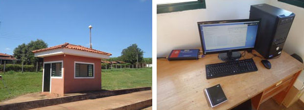
The monitoring station in Brazil uses a Septentrio PolaRxS receiver to monitor the ionosphere, a Septentrio AsteRx3 to perform tests static and kinematic tests, and three RTK Altus APS3 receivers (one as a base station and two as rovers.)
After 27 months of intensive research, a project team funded under the European Union’s 7th Framework Programme has come up with a solution to counter the problem of ionospheric disturbance affecting GNSS signals.
The CALIBRA project recently showcased a commercially applicable approach to mitigate the phenomenon’s impact on high-accuracy GNSS positioning techniques. In two demonstrations, the project’s newly developed algorithm was successfully tested in actual precision agriculture and offshore operations.
Solar flares can cause ionospheric disturbance, a sudden increase in radio-wave absorption that often delays the propagation of signals and ultimately affects positioning. The problem has kept researchers busy for years.
The CALIBRA project team has been participating in this global research effort by focusing on Brazil, which is one of the most exposed regions due to its proximity to the magnetic equator. Add to this that the sun is at its peak of activity since it entered its new 11-year cycle in 2010.
The project achieved three main milestones. First, the team confirmed that ionospheric scintillation and variations in total electron content (TEC) had a direct impact on the functioning of high accuracy GNSS techniques, such as Precise Point positioning (PPP) and real-time kinematic (RTK) positioning. Then a suitable metric was established to characterize these ionospheric disturbances. Finally, the project produced a short-term empirical model for forecasting TEC and scintillation. A regional TEC map was developed which proved advantageous for use in Brazil and, to counter scintillation, a number of approaches for the mitigation of this phenomenon were proposed and their benefit demonstrated.
The project exploited the CIGALA-CALIBRA network and database — a network of ionospheric scintillation monitor receivers with a web interface (the ISMR Query tool), which collects more than 10 million observations on GPS, GLONASS, Galileo, BeiDou and other global navigation systems every day. Since it was launched in December 2014, this data has helped assist users from more than 20 countries because of the software’s visualization and mining techniques.
In light of this success, CALIBRA partners INGV (Istitute Nazionale di Geofisica e Vulcanologia) filed a patent for their forecasting model, and a new spin-off company — SpacEarth Technology — was set up. SpacEarth’s main purpose is to secure the software’s commercialization in relevant applications and services, while also improving and adapting it to evolving market needs.
The project’s results promise to considerably reduce downtime and financial losses caused by ionospheric disturbance in Brazil and other regions of the world. Learn more about the project here.
Space News is reporting that the U.S. government has alerted the European Union that any preferential treatment the EU gives to its Galileo positioning, navigation and timing network will likely violate World Trade Organization (WTO) agreements signed by the United States and the 28-nation EU.
According to a report by Peter B. de Selding, U.S. government officials voiced concerns that the EU is weighing equipment mandates for aviation, car-accident reporting and emergency-call regulations that could unfairly tip the scales in favor of Galileo to the detriment of U.S. GPS-enabled hardware.
In a presentation to the 9th Meeting of the International Committee on GNSS, held Nov. 10-14 in Prague, a senior GPS official said the United States and the EU have signed a wide body of satellite navigation agreements designed to promote open market access and interoperability.
European Commission officials have said in recent months that they are still weighing how to stimulate Galileo use.
The cause of two Galileo satellites being released into the wrong orbit August 22 can be traced to improper installation of a hydrazine fuel line, according to Space News and the GalileoGNSS blog.
The hydrazine fuel line was installed too close to a supercold helium line on the Fregat upper stage, which caused the hydrazine to freeze long enough to upset the Fregat stage’s orientation and cause the two satellites’ release into an orbit that is both too low and in the wrong inclination, officials said as reported on the websites.
No official report has been issued; the board of inquiry is expected to release its findings this week.
The Euro-Russian inquiry board looking into the cause of the failure has discovered that one in four Fregat upper stages at prime contractor NPO Lavochkin in Moscow had the same fuel-line installation, according to the reports. “We have to assume that this was a practice that had gone on in perhaps a quarter of the Fregat stages produced in the past decade, but that it had not affected our launches up to now because of mission-specific aspects like coast time between burns, the number of burns and so on, which can influence the effect of the helium on the hydrazine,” one official is quoted as saying. “In any case, we’d like Arianespace, which currently has almost no inspection rights on the Soyuz, to be given more say in quality assurance.”
In the stages without the installation issue, the hydrazine and helium lines were separated so that the supercold helium could not freeze the hydrazine. The design did not foresee any problem in putting the lines together, but in fact that is a problem for some missions.
European Union government and officials are debating how to proceed, the reports said. The options are to continue, as scheduled, with the December launch of two more Galileo satellites aboard a Soyuz Fregat rocket, or to wait until next spring or summer and launch four Galileo satellites on a heavy-lift Ariane 5 vehicle.
As for the two wayward satellites, in a presentation to the 65th International Astronautical Congress in Toronto September 30, OHB’s Galileo deputy program manager, Kristian Pauly, said he was optimistic that once the satellites’ perigee is raised and their orbit made less eccentric, they can be fitted at least partially into the Galileo program and perform a navigation function, Space News reported. OHB System is the prime contractor for the full operational capability (FOC) satellites.
The first priority, Pauly said, is to take the two satellites out of regular contact with the Van Allen belts and adjust their Earth sensors to their new, unplanned view of Earth — which is much closer given the lower altitude.
Pauly did not speculate on what the Galileo launch schedule would be. He said that OHB’s delivery schedule will not change much. “We have a delivery schedule that is extremely challenging and we will keep to it,” he said.
In the presence of the European Commission, the European GNSS Agency (GSA) and EuroControl have signed a new cooperation agreement to jointly contribute to the implementation of European Union GNSS policies as they apply to the field of aviation.
As Europe’s skies and major airports become increasingly congested, there is need for Air Traffic Management (ATM) technologies to evolve from ground-based infrastructures to more advanced systems based on new technologies. EuroControl and the GSA have a shared objective in developing and exploiting European GNSS technology to improve accessibility, efficiency and safety to European operators, pilots and airports.
To accomplish this objective, the agreement focuses on a range of activities, including:
Definition of aviation user requirements for EGNOS and Galileo
Introduction of European GNSS services for aviation within the European Civil Aviation Conference (ECAC) area
Coordination in aviation research and development
Aviation-specific GNSS performance monitoring
Promotion of European GNSS aviation activities at the international level
“This is another example of European Commission support of the aviation sector,” said Daniel Calleja Crespo, director general of DG Enterprise and Industry at the European Commission. “I am confident that a strong cooperation between the GSA and EuroControl will benefit aviation, the European GNSS Programs and indeed European citizens.”
“The full deployment of GNSS offers unprecedented opportunities to further improve air traffic management safety and capacity, while reducing costs at pan-European level,” said GSA Executive Director Carlo des Dorides. “EuroControl’s activities in this field will complement those of the GSA to ensure that the development and implementation of satellite-based navigation provides an optimal solution for European airspace users.”
“EuroControl and the GSA share a common objective — the secure and safe implementation of European satellite navigation policies in the aviation sector. The enhanced cooperation between our two organizations means that EuroControl will now bring its unequaled capacity to understand, coordinate and represent the needs of the civil and military airspace users to the promotion and development of GNSS,” said Frank Brenner, director general of EuroControl.
EGNOS is Europe’s first venture into satellite navigation and has been providing a certified safety service for aviation users since 2010. EGNOS is owned by the European Union and, since January 1, 2014, the GSA is responsible for its exploitation, ensuring service provision, operations, maintenance and evolution.
Rockwell Collins’ flight management system (FMS) and GNSS receiver successfully enabled the first demonstrations of advanced arrival and departure flight operations for the European Union’s airspace-enhancing project FilGAPP (“Filling the Gap” in GNSS Advanced Procedures and Operations).
The goal of FilGAPP is to create new, more efficient methods of navigating airspace using satellite-based navigation and advanced FMS functions.
“FilGAPP highlights the opportunity that exists for air carriers and corporate operators to increase operating capacity and to save time and fuel through more efficient terminal procedures at European airports,” said Claude Alber, vice president and managing director, Europe, the Middle East and Africa (EuMEA) for Rockwell Collins.
The most recent demonstration, performed in Germany in collaboration with key FilGAPP operational partners, took place on a Hawker 750 aircraft equipped with Rockwell Collins’ FMS and GNSS receiver. It was the first time that a high precision and high integrity missed approach/departure was performed in Europe.
The flights also validated technical and operational independence from the closely spaced air traffic control systems of two nearby airports, which enabled increased operational capacity for each airport.
Similar advanced departure/arrival demonstrations as part of project FilGAPP were performed earlier in the year with Air Nostrum (Iberia Regional) in Spain on Bombardier CRJ-1000 aircraft equipped with Rockwell Collins systems. The trials took advantage of the radius-to-fix functionality connected to European Geostationary Navigation Overlay Service (EGNOS)-enabled localizer performance with vertical guidance (LPV) approaches.
FilGAPP is a project of the European Commission’s 7th Framework Program managed by the European GNSS Agency (GSA) and coordinated by the Spanish transport consultancy, INECO, with industry and national air navigation service provider partners, including Rockwell Collins.
Not so long ago, we occasionally speculated on the order of GNSS preference for both manufacturers and end users. GPS first, of course. Only the most radical of future visions saw anything different. But after that? GLONASS, Galileo, BeiDou — or switch them around? A case could be made for almost any sequence, by virtue of active constellation size or geometry, code structure, interoperability, government funding, or national economies.
It was once felt that a maximum of two GNSS could be made to fit cost-beneficially on a chip destined for mass-market devices; professional OEM boards had, of course, far more leeway and budget. Then engineering ingenuity found space for three on a chip.
A wag noted during that timeframe that in GNSS as in the Olympics, one can win gold, silver, or bronze. There is no prize for fourth place.
Lately, however, it seems there may be room for all. Our feature article this month affirms that “the silicon manufacturer must continue the path towards the fully flexible multi-constellation mass-market receiver.”
Nevertheless, choices will be made in design and manufacturing: different choices by different manufacturers in different regions, on different products. I now think that market size and connectivity will be the strongest drivers for selection of GNSS in product design. Constellations, at least in their order of establishment, almost don’t matter. Government mandates to use the respective national (or regional) GNSS in official or officially linked applications will add to the weight of market size.
These government-mandated applications encompass air, rail, and maritime navigation and management, survey and construction, road tolling, and road-user charging, just to start with. With emergency calling, it’s not hard to envision such mandates extending to telecomm as well, the most plentiful in end-user devices.
In that light, consider the words of political scientist John McCormick from his book Why Europe Matters.
“The European Union has a population of more than half a billion. It is the wealthiest marketplace in the world, is the biggest trading power in the world, is the biggest source of (and magnet for) foreign direct investment, and has shown that it is possible to wield influence without relying on military power.”
Even should Galileo finish fourth in the race to establish a full constellation, smart money may put Galileo on every future GNSS chip, high precision or mass market.