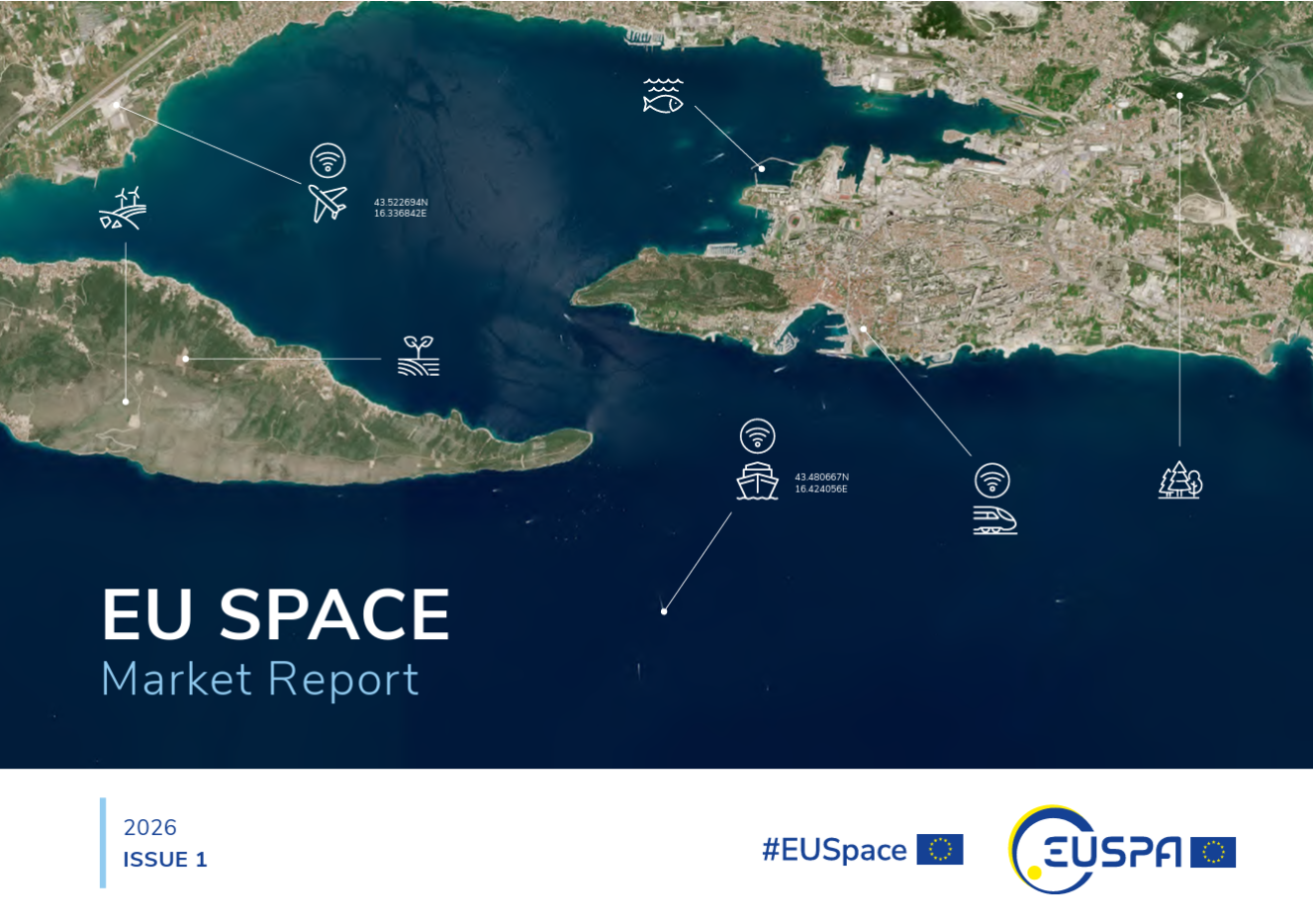
A new edition of the European Union’s Space Market Report is now available. According to the EU’s Agency for the Space Programme (EUSPA), it offers a comprehensive overview of the latest developments, emerging trends, and market dynamics shaping the global space downstream sector.
The report provides a comprehensive overview of the latest developments and trends in GNSS, as well as Earth observation (EO), secure satellite communications (Secure SATCOM), and space situational awareness (SSA) in one place for the first time. It also highlights the evolution of user technologies and the growing synergies between these domains.
“As Europe’s space capabilities become increasingly interconnected, it is essential to move beyond viewing them as standalone technologies,” explained Rodrigo da Costa, EUSPA executive director. The publication “reflects the growing synergies between these domains and their strategic importance for Europe’s economy, resilience and autonomy.
“By providing a comprehensive view of the evolving space ecosystem, EUSPA aims to foster innovation, strengthen collaboration across the sector, and support the development of a more competitive, agile and responsive European Union space economy,” da Costa said.
GNSS and EO
The report highlights sustained growth for both the GNSS and EO markets across all 16 analyzed market segments. The current €3.5 billion of EO market revenue in 2024 is expected to grow to €7.9 billion by 2034 with agriculture representing the largest share.
GNSS revenues are forecast to rise from €300 billion in 2024 to €580 billion by 2034. GNSS service revenues outpace device revenues and confirm the increasing role of digital ecosystems and value-added services in the space economy, the report said.
Revenues are mainly driven by consumer solutions, and road and automotive, with a global installed base of GNSS-enabled devices that will reach almost 10 billion by 2034.
Secure SATCOM
The Secure SATCOM market addresses the needs of surveillance, key infrastructure and crisis management. In this sector, data service revenues generated by EU users are forecast to grow significantly, increasing from more than €200 million in 2025 to nearly €1.2 billion by 2040.
While maritime surveillance drives demand in 2025, by 2040 the market is expected to be led by law enforcement interventions, civil protection and force deployment, fueled by growing security and resilience needs, demand for reliable connectivity, and stronger crisis-response capabilities.
Existing and future synergies
The report also examines how major macroeconomic trends —including climate change, geopolitical instability and rapid urbanization — are reshaping space markets and strengthening synergies between EO, GNSS and Secure SATCOM technologies. Together, these capabilities are becoming increasingly important for security, resilience, disaster response, environmental monitoring, and smarter urban and infrastructure management.
The European Union PAVE-SCAN project aims to build European GNSS-based and AI-driven technologies to detect and assess roadway pavement problems.
The proposed project aims for the development to market (TRL8-9) of European GNSS-based integrated low-cost sensor technologies and artificial-intelligence-driven open-architecture software solution — machine learning (ML) and machine vision (MV) — for the detection, classification and georeferencing of roadway pavement surface anomalies, and for the low-cost assessment of roadway pavements using participatory sensing.
The proposed system is of practical importance because it provides continuous information about roadway pavement surface anomalies — valuable for efficiently monitoring the transport infrastructure and for public safety. The vision for roadway condition assessment using smartphone-like technology is under the hypothesis that such technology can be used for crowd-sourced data collection and analysis in GIS-based pavement management systems (PMS).
“The developed technology and related transport informatics are disruptive technologies that have the potential to reshape the transport and infrastructure industries,” according to the project description.
Near-real-time analysis and classification of roadway anomalies
WP3,WP4,WP5
2
Geospatial mapping of transport infrastructure, roadway anomalies and condition-assessment heatmaps
WP3,WP4,WP5
3
Geospatial mapping of transport infrastructure, roadway anomalies and condition-assessment heatmaps
WP3,WP4,WP5
4
Improved roadway management practices, prioritisation of public works & lower costs
WP4
5
Reduction in the transport-related environmental footprint through improved O&M of transport infrastructure and of mass transit
WP4,WP6,WP7
6
Reduction in roadway-assessment costs by utilization of a fleet of vehicles/buses as participatory sensors
WP5,WP6,WP7
7
Integration with national transport initiatives (e.g., National Single Access Point), & with Digital Twin platforms, for dynamically updated roadway-condition models, and improvements in transport safety through roadway improvements
WP4, WP5
8
Open-access data and APIs
WP1, WP8
9
Product to market and ‘Product as a Service’ (PaaS) business model
The International Air Transport Association (IATA) and the European Union Aviation Safety Agency (EASA) have published a comprehensive plan to mitigate the risks stemming from GNSS interference. The plan was among the conclusions of a jointly hosted workshop on the topic of GNSS interference.
Given the continued rise in frequency of interference with GNSS signals, the workshop concluded that a broader and more coordinated approach is needed. focusing on four key areas: improved information gathering, stronger prevention and mitigation measures, more effective use of infrastructure and airspace management, and enhanced coordination and preparedness among relevant agencies.
Reported incidents of interference with GNSS signals have been increasing across Eastern Europe and the Middle East in recent years. Similar incidents have been reported in other locations globally. The initial response focused only on containing those GNSS interference incidents.
“GNSS disruptions are evolving in terms of both frequency and complexity,” said Jesper Rasmussen, EASA Flight Standards director. “We are no longer just containing GNSS interference — we must build resilience. The evolving nature of the threat demands a dynamic and ambitious action plan. Through collaboration with partners in the European Union and IATA, and by supporting the International Civil Aviation Organization (ICAO), we are committed to keeping aviation safe, secure and navigable.”
The number of GPS signal loss events increased by 220% between 2021 and 2024, according to IATA’s data from the Global Aviation Data Management Flight Data eXchange (GADM FDX). “With continued geopolitical tensions, it is difficult to see this trend reversing in the near term,” said Nick Careen, IATA senior vice president, Operations, Safety and Security. “IATA and EASA are working together to reinforce the redundancies that are built into the system, to keep flying safe. The next step is for ICAO to move these solutions forward with global alignment on standards, guidance and reporting. This must command a high priority at the ICAO Assembly later this year. To stay ahead of the threat, aviation must act together and without delay.”
Detailed Workshop Outcomes
The workshop concluded that four workstreams are critical.
1. Enhanced Reporting and Monitoring
Agree on standard radio calls for reporting GNSS interference and standardized notice to airmen (NOTAM) coding, i.e. Q codes.
Define and implement monitoring and warning procedures, including real-time airspace monitoring.
Ensure dissemination of information without delays to relevant parties for formal reporting.
2. Prevention and Mitigation
Tighten controls (including export and licensing restrictions) on jamming devices.
Support the development of technical solutions to:
reduce false terrain warnings;
improve situational interference with portable spoofing detectors; and
ensure rapid and reliable GPS equipment recovery after signal loss or interference.
3. Infrastructure and Airspace Management
Maintain a backup for GNSS with aminimum operational network of traditional navigation aids.
Better utilizemilitary air traffic management (ATM) capabilities,including tactical air navigation networks and real-time airspace GNSS incident monitoring.
Enhance procedures for airspace contingency and reversion planning so aircraft can navigate safely even if interference occurs.
4. Coordination and Preparedness
Improve civil-military coordination, including the sharing of GNSS radio frequency interference (RFI) event data.
Prepare for evolving-threat capabilities, also for drones.
The workshop was held at EASA’s headquarters in Cologne, Germany, on May 22-23, and was attended by more than 120 experts from the aviation industry, research organizations, government bodies and international organizations.
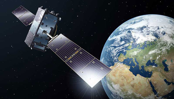
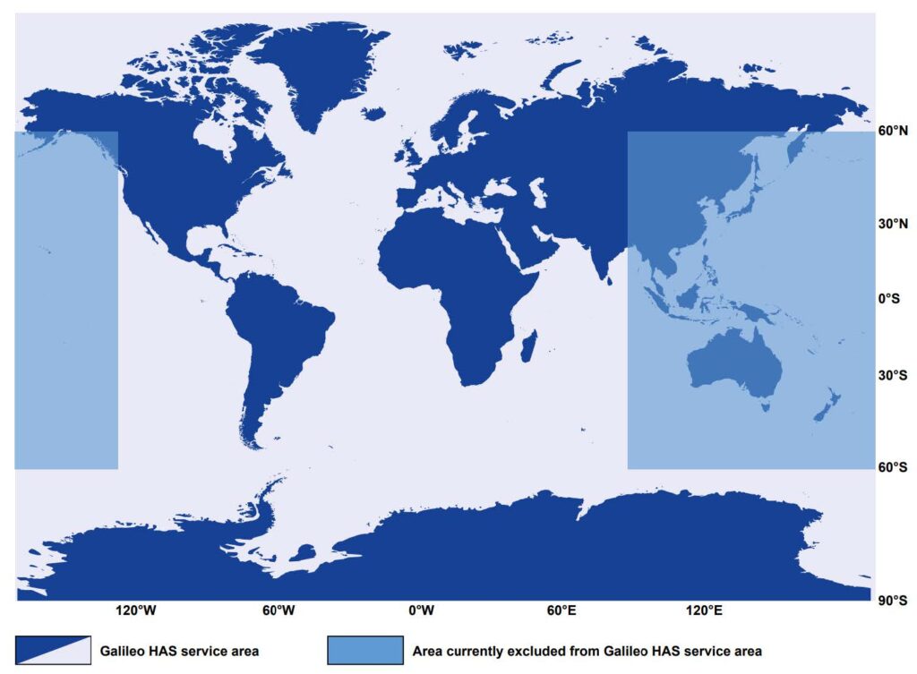
Developed by the European Union, Galileo is an independent, global, satellite-based navigation system that provides a range of services. Among its most significant advancements is the Galileo High Accuracy Service (HAS), which aims to offer free, high-precision positioning to users worldwide. This article explores Galileo HAS, covering its history, architecture, implementation phases, performance, limitations, and future prospects.
What is the Galileo High Accuracy Service?
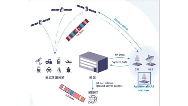
Galileo HASis a precision augmentation service leveraging precise point positioning (PPP) to provide corrections to GNSS signals, aiming at a positioning accuracy of less than 20 cm horizontally and 40 cm vertically. Unlike the traditional real-time kinematic (RTK) method, which depends on local reference stations, HASdelivers corrections globally via Galileo satellites using the E6-B signal, as well as over the Internet. The service provides corrections for measurements on multiple frequencies across both Galileo and GPS constellations, enhancing real-time positioning performance.
The concept of a high-accuracy service for Galileo was driven by growing demand for decimeter-level accuracy in applications such as precision agriculture and autonomous vehicles. Initially envisioned as a paid service under the Galileo Commercial Service, feasibility studies in 2014 confirmed its potential. In 2018, the European Commission decided to offer HASfree of charge.
In the Galileo HASspecifications, two Service Levels are defined. Service Level 1 with global availability and the enhanced Service Level 2 for the European Coverage Area. The Galileo HASroadmap consists of three phases: Phase 0 (testing and experimentation), Phase 1 (Initial Service), and Phase 2 (Full Service). After extensive internal testing, Phase 1 was officially launched in January 2023, marking a significant milestone in Galileo’s evolution as a leading GNSS provider. Phase 2 is currently in development and expected to launch in the near future.
Technical Components
Galileo HASis designed with several key components that enable its high-precision capabilities. One of the most critical aspects involves orbit and clock corrections. These corrections compensate for inaccuracies in satellite orbital positions and clock errors, which are major sources of positioning errors in standard GNSS. Another essential element of HAS is the provision of signal bias corrections to enable precise carrier phase ambiguity resolution, which in turn greatly improves positioning accuracy. In the current Initial Service (Phase 1), Service Level 1provides only code bias corrections, along with orbit and clock corrections. In Phase 2, Service Level 1 will be upgraded to include both code and phase bias corrections, while Service Level 2will further add atmospheric (ionospheric and tropospheric) corrections for the European Coverage Area.
Capable GNSS receivers decode the high-accuracy corrections broadcast on the E6-B channel for Galileo (E1, E5a, E5b, E5, AltBOC, E6) and GPS (L1, L2, L5) signals and apply them via algorithms to enhance positioning solutions. This refines raw measurements to reduce errors, providing decimeter-level accuracy for use in fields rangiranging from ecological surveys to city infrastructure management and routine mapping tasks.
In addition to satellite broadcasts, the corrections are also made available over the Internet via the NTRIP protocol, providing an alternative access method for users with network connectivity. Notably, receiving HAS corrections via NTRIP eliminates the need for a receiver with E6-B capability, but the receiver still needs to implement the PPP algorithm to process the corrections.
Architecture
The Galileo HASrelies on the robust infrastructure already established within the Galileo system. At the foundation of this network are the Galileo Sensor Stations (GSS), a global network of 15 monitoring stations (according to the latest updates). These stations play a vital role by continuously collecting GNSS measurements, which serve as the raw data needed to generate precise corrections. The collected data are then processed by the High Accuracy Data Generator (HADG). This system analyzes the GSSinput and produces high-precision corrections for both Galileo and GPS signals. Once the corrections are prepared, they are transferred to Uplink Stations (ULS), which transmit the correction data to the Galileo satellites for distribution via Signal-in-Space, or to an NTRIP caster for distribution over the Internet. In the case of Signal-in-Space distribution, the Galileo satellites themselves serve as the delivery mechanism to users worldwide, broadcasting the corrections globally via the E6-B signal.
The HAS is being rolled out in three phases, ensuring progressive development and refinement:
Phase 0 (2020–2022): Internal Testing
Focused on validating the feasibility of broadcasting HAS corrections via the E6-B signal.
Tests involved internal and external stakeholders, with feedback used to refine the service.
Phase 1 (January 2023–Present): Initial Service
Declared operational on January 24, 2023, Phase 1 provides Service Level 1 with global coverage, though with reduced performance compared with the enhanced Service Level 1 expected in Full Service (Phase 2).
Current corrections include orbits, clocks, and code biases.
The service area excludes certain regions (e.g., parts of the Pacific and Australia) because of infrastructure limitations.
Convergence time is specified as <300 seconds (Service Level 1) or <100 second (Service Level 2), with horizontal accuracy <20 cm and vertical accuracy <40 cm under optimal conditions. Currently, accuracy <20 cm may be achieved with a convergence time up to 60 minutes, owing to the lack of phase bias and atmospheric corrections.
Phase 2 (Future): Full Operational Capability
Will provide full Service Level 1 performance globally with horizontal accuracy <20 cm and vertical accuracy <40 cm, adding phase bias corrections for faster convergence <300 seconds.
Will introduce Service Level 2 for regional coverage in Europe with horizontal accuracy <20 cm and vertical accuracy <40 cm, adding phase bias and atmospheric corrections for faster convergence (<100 seconds).
Will include data authentication and enhanced infrastructure for improved reliability and coverage.
Challenges and Limitations
The current capabilities of Galileo HASare constrained by several limitations, which are expected to diminish as the system evolves. Global coverage is not yet fully established, with parts of the Pacific region and Australia remaining outside the service area. While users can receive HAScorrections anywhere in the world, the official performance specifications apply only within the service boundaries. However, even within the service area, achieving the specified accuracy presently requires long convergence times, limiting applicability in scenarios that demand rapid solutions. Convergence time is expected to decrease significantly in Phase 2, when phase bias and atmospheric corrections are introduced.
As of 2025, relatively few commercial receivers support HAScorrections via E6-B, with availability concentrated in professional and industrial receivers. The lack of integration into mass-market devices limits broader adoption, reflecting both the technology’s ongoing development and the additional hardware complexity required to receive HAScorrections.
Finally, while decimeter-level corrections are sufficient for a wide range of applications, many professional domains, such as surveying, demand cm-level accuracy. Even at Full Service, HASwill not provide this level of precision, meaning that certain fields will continue to rely on RTK. However, considering that most RTK vendors require a paid subscription or charge per hour, HAScan still provide great value to surveyors and other professionals through its use in preliminary work or applications where cm-level accuracy is not critical, offering decent accuracy free of charge.
The Galileo constellation was recently reinforced with satellites 31 and 32, which became operational in January 2025, while the ground segment underwent major upgrades in 2024. Despite these improvements, Phase 1 (Initial Service)remains the only operational HAS capability. As of September 2025, Phase 2remains in active development. In January 2025, it was announced that the European Union Agency for the Space Programme (EUSPA) awarded GMV a 45-month, €12 million contract to develop an enhanced HADGthat will support enhanced Service Level 1 globally and Service Level 2 for Europe. The contract’s duration provides an indication of the anticipated timeline for completion.
An inquiry regarding the timeline for Galileo HASService Level 2 (Phase 2) was submitted to the European GNSS Service Centre (GSC) Helpdesk. Their reply stated that the schedule is not available at this time and will be announced through GSC channels once released.
Wider adoption is anticipated as more GNSS receivers capable of receiving and decoding the E6-B signal to process HAScorrections become available, enabling sectors such as autonomous transportation, fleet management, and smart agriculture to capitalize on improved performance. Adoption is also expected to accelerate when Galileo HAS reaches Full Operational Capability with the launch of Phase 2, which will reduce convergence times and broaden the system’s applicability.
Ultimately, Galileo HASis positioned to become a cornerstone of high-accuracy GNSS, democratizing access to professional-grade precision.
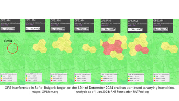
On Dec. 12, 2024, the European Union decided to include Bulgaria and Romania in the Schengen visa-free zone. On the same day, Bulgaria’s capital, Sofia, began experiencing interference with GPS signals. The interference, as reflected in aviation ADS-B systems and reported on GPSJam.org, continued through the new year and is ongoing as of this writing.
While these two events may be entirely unrelated, Vladimir Putin has a history of using GPS jamming and spoofing to show his displeasure with his neighbors growing closer to the West.
On Dec. 15, 2023, Poland activated a U.S. Aegis anti-missile system near its border with Kaliningrad, Russia. On the same day, Russia began jamming and spoofing GPS signals in northern Poland and parts of the Baltic. That interference persists to this day.
The interference in Sofia may be contributing to a prolonged Bulgarian political crisis. Politicians there have been struggling to form a new government since elections in October. Dec. 10 saw the beginning of a new attempt. Interference with GPS can undermine overall confidence in government systems and institutions — another of Putin’s goals for neighbors with whom he is displeased.
Another, though less likely, impact may be on Bulgaria’s electrical service. On Dec. 25, 2024, 20,000 households in western Bulgaria (Sofia is in the far west) lost electrical power and the outage continued for days. Many grid operators use GPS timing to help manage their systems. While press reports put the outages down to heavy snow and fallen trees, increased difficulty managing the grid might also be a factor.
Bulgaria’s GPS interference appears to be coming from somewhere in Sofia, not from Russian territory, as is the case in the Baltic. Yet Russia may still be involved, at least in a supporting role.
The European Union Agency for the Space Programme (EUSPA) has awarded a contract to a consortium led by GMV to design, develop and deploy the communications hub for the Governmental Satellite Communications (GOVSATCOM) programme. This contract, valued at up to €107 million ($119 million), is a critical component of the European Union (EU) satellite communications initiative.
GOVSATCOM is one of the five main components of the EU Space Programme, alongside Copernicus, Galileo, EGNOS and Space Situational Awareness. Its primary objective is to provide secure and cost-efficient satellite communication services to authorized governmental users in EU Member States.
The program aims to support various scenarios, including crisis management, border and maritime surveillance, critical infrastructure management and security operations in polar regions.
The communications hub is a critical element of the GOVSATCOM architecture. Its main functions include:
Ensuring optimal delivery of satellite communication services
Meeting the demand for operational services from EU Member State users
Planning for predefined medium-term communication needs
Handling dynamic and urgent requests from unforeseen scenarios
Operating under strict security and resilience requirements
The hub will manage satellite communication resources from EU Member States and services provided by the EU’s future multi-orbital secure communications constellation, IRIS2.
The consortium led by GMV includes Indra and Hisdesat. The contract was awarded following a competitive bidding process involving pre-selection consortia and execution of parallel contracts for preliminary design and capability demonstrations.
In October 2023, the United Kingdom’s government announced a 10-point “policy framework” to greatly increase the nation’s resilience to disruption of vital positioning, navigation and timing (PNT) services.
Two months later, Vladimir Putin began regularly jamming and spoofing GPS for aircraft and ships across a broad swath of the Baltic and northern Europe. It was the world’s first instance of such extensive activity in the absence of armed combat.
Properly executed, Britain’s policy framework will position it as a global leader in sovereign and resilient PNT. It will also provide ample new business opportunities for British businesses to fill this growing need.
The product of years of effort under both Coalition and Conservative governments, the PNT policy framework addresses challenges that have been extensively documented and studied.
The nation’s over-reliance on space- based PNT has long been recognized. Its National Risk Register listed solar activity as a threat to PNT in 2012. When, despite extensive lobbying by the UK, the rest of Europe shut down its Loran transmitters in 2015 to prevent competition with Galileo, Britain kept its single transmitter on air as a national precise time reference. In 2018 a “Blackett Report” documented the nation’s over-dependence, estimated the consequences of service outages and made a series of recommendations. A 2021 economic report further estimated the scale of the problem.
All this well before Russia’s demonstrations of the fragility of GNSS with its attacks on Ukraine and recent aggression in the Baltic.
Yet action on Britain’s way forward was repeatedly deferred.
The sticking point seems to have been deciding upon the mechanics of how the government would deal with the invisible PNT utility, which is a capability essential to every government department and every sector of the economy and society. Should it be in the Department for Transport? Perhaps in Business and Trade or Defence? Some suggested the Cabinet Office should lead addressing the PNT challenge.
The final decision was a cross- government office hosted by the Department for Science, Innovation and Technology. The office includes members from the Ministry of Defence and is tasked with leading and coordinating a whole-of-government approach.
Moving Forward
It is easy to be skeptical about the success of this new enterprise. Regardless of the nation, government policy frameworks, strategies and the like often can be a way for politicians and bureaucrats to create the impression of action without having to ever really do anything. Documents are often published and then go on a shelf, never to be seen again.
That does not seem to be the case here, though.
The very first action item in the PNT policy framework is to “[e]stablish a National PNT Office …to improve resilience and drive growth with responsibility for PNT policy, coordination, and delivery.”
While several of the 10 items begin with “develop a proposal for…,” the projects are both considered and specific, such as a timing system “of last resort” for the Ministry of Defence and the expansion of eLoran.
Britain’s integrated governance and system-of-systems approach to PNT can make the nation virtually immune to the kinds of disruptions and infrastructure challenges being seen in the Baltic and conflict zones around the world.
Achieving that goal will involve the development of new user equipment, systems to prioritize and integrate different PNT sources, new interfaces for various infrastructures, improvements to existing technologies (e.g., an encrypted component for eLoran to make it even more secure and reliable), and new policies for responsible PNT use in critical applications.
When complete, the UK will have the sovereign and resilient PNT it needs to support national, homeland and economic security.
Global Leadership and Profit
Yet Great Britain is not the only nation over-dependent on fragile PNT signals from space provided by others. Most of the world is in the same situation.
By actively promoting and sharing its developing expertise and tech stack, the UK will become a global thought leader and technology provider for sovereign and resilient PNT. A capability that will be in greater and greater demand as malicious actors, both large and small, continue to exploit the weaknesses of satellite-based navigation and timing.
Yet, to realize these benefits, the UK must act swiftly and seize the moment.
At present there is a leadership vacuum in this field. While China has its own extremely robust and integrated PNT system based on a combination of clocks, fiber, terrestrial broadcast eLoran, and space, it does not seem eager to export that to others. China may prefer to woo nations into dependence on its BeiDou satellite PNT system, rather than enabling others’ sovereignty.
Additionally, while entrepreneurial South Korea has implemented its own space-based, eLoran and fiber PNT, it is unclear how integrated the various sources are. We have also seen no evidence that they have plans to share, or sell, their success to others.
As disruptions to GPS and other GNSS continue to increase around the globe, so, too, do calls for and moves toward solutions that include alternatives.
Last year the European Union issued a tender for an integrated GNSS/eLoran receiver. Türkiye has implemented its own local terrestrial PNT systems in several port and urban areas. India envisions expanding its regional navigation satellite system to cover the globe.
Britain has the plans, capability, and resources to become the world leader in this essential and growing technology sector — and the government is working with the Royal Institute of Navigation and other learned bodies to make it a reality.
Yet its window of opportunity may already be closing.
Rather than regarding its PNT policy framework as a routine item of work, we hope the UK government seizes this opportunity for international leadership and reaps all the inherent diplomatic, security and economic benefits.
The European Union is in the final stages of completing a deal with SpaceX to launch four Galileo navigation satellites in 2024, reported SpaceNews.
In press briefings during the European Space Summit in Seville, Spain, Thierry Breton, the European Commission’s commissioner for the internal market, said that he was “finalizing the discussions” for a pair of Falcon 9 launches, each carrying two Galileo satellites, tentatively scheduled for April and July of 2024.
Brenton also said that the final obstacle to completing the launch contract was negotiating a security agreement to protect sensitive technologies on the Galileo satellites, which previously had been launched from the European spaceport in French Guiana, when those satellites are being prepared for launch from the United States.
The launch contract itself was completed in July, Breton noted, and that the European Commission had approved a European Space Agency proposal to use the Falcon 9 for launching those satellites. He said the European Commission would spend $192 million on the Falcon 9 launches.
During a recent meeting of the European Space Agency (ESA) Council, ESA Director General Josef Aschbacher said that the final decision for using SpaceX to launch the Galileo satellites was in the hands of the Commission.
“We have prepared on the ESA side the contractual arrangements with an external launch company, but whether or not the launch will be decided to take place with SpaceX is not in our hands,” he said. “the European Commission will decide.”
There had been discussions for more than a year about using a non-European rocket, such as the Falcon 9, for launching those satellites because of delays in the Ariane 6, the retirement of the Ariane 5 and the withdrawal of the Soyuz after Russia’s invasion of Ukraine. Those satellites would augment the existing operational Galileo constellation and serve as on-orbit replacements if other satellites fail.
ESA had already contracted with SpaceX for three Falcon 9 launches. The ESA said it chose the Falcon 9 after the loss of the Soyuz, delays in the Ariane 6 and concerns about the Vega C, which remains out of service since a launch failure in December 2022.
SpaceX has signed a deal to launch four of Europe’s flagship navigation and secure communications satellites into orbit, reported The Wall Street Journal. The European Commission and the European Union (EU) member states have yet to give a final approval for the deal, the report added.
SpaceX and the European Space Agency recently signed an agreement for two launches next year, each carrying two Galileo satellites.
The deal states the satellites will be launched from the U.S. on SpaceX’s Falcon 9 rocket.
European space officials said last month they face crucial timing decisions in the coming weeks on the return to flight of Europe’s flagship space launchers following a series of delays.
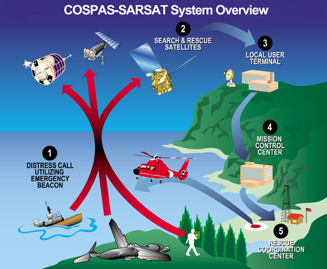
Thales Alenia Space, along with Viettel and MKE, have been selected by Vinamarine to provide Vietnam with a MEOLUT Next ground station. MEOLUT Next will operate as a part of the COSPAS-SARSAT global medium orbit search-and-rescue (SAR) network.
The SAR solution will enable the detection and location of distress signals from COSPAS-SARSAT beacons on land, in the air, and at sea over a radius of 2,500 km around Haiphong, Vietnam, mainly using signals from Galileo.
Thales Alenia Space’s MEOLUT Next solution employs a phased array antenna and can track more than 30 satellites, which enhances distress beacon detection and expands coverage. The solution can detect and locate distress signals from more than 5,000 km away.
MEOLUT Next is used by other COSPAS-SARSAT users including Canada, the United States, France, the European Union, Togo and Thailand.
The European Union Space Programme Agency (EUSPA) has signed a framework contract entrusting France’s space agency with providing Galileo search-and-rescue (SAR) services. The 137 million euro 10-year contract includes maintaining assets in operational condition, coordinating with the host sites and interfacing with the Cospas-Sarsat community.
Image: EUSPA
The National Centre for Space Studies (CNES) has been responsible for operations of SAR-Galileo services for the European Union since 2016, providing the SAR-Galileo Forward Link Service and the Return Link Service. The coordination of operations and maintenance of the ground segment, deployed across Europe, is headquartered at the space center in Toulouse, France.
A network of reference beacons enables evaluation of the performance of the systems in real-time. CNES also provides its expertise to EUSPA for the definition of international standards, performance monitoring and future developments.
Emergency position-indicating radio beacon-based services is an addition to the framework contract. CNES has already been identified as the future operator of the Emergency Warning Service, an alert service for European communities scheduled to begin operations in 2024.
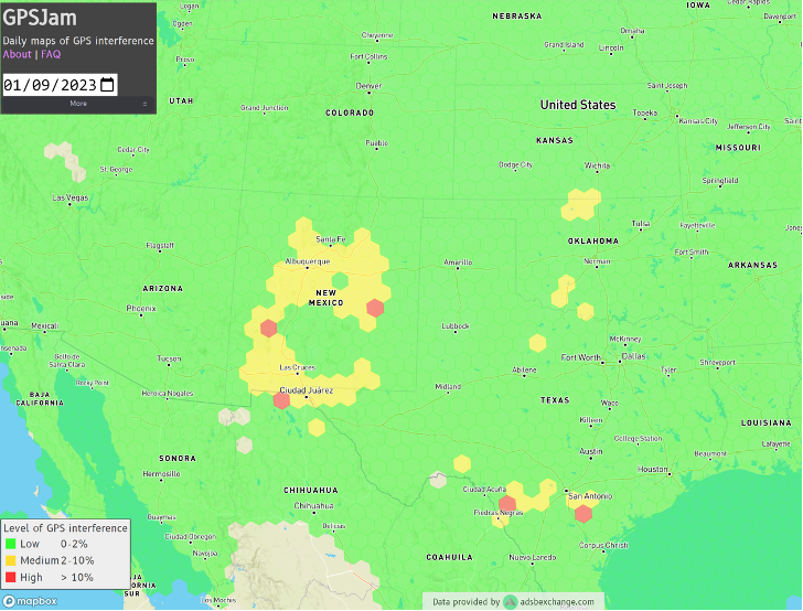
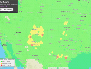
Ever since it came on-line in February 2022, the website GPSJam.org has shown what appears to be regular interference with GPS signals in Texas near San Antonio and Del Rio, and locations north and south of Oklahoma City, Oklahoma.
Only on normal workdays, however. Not on weekends or holidays. Furthermore, whatever was happening also took time off between the Christmas and New Year holidays GPSJam.org also shows similar, though less regular, activity in New Mexico. Experts say this is easily explained as White Sands Missile Range is often the site of electronic warfare training and tests. These are always announced in advance in FAA Notices to Air Missions (NOTAMs) when any interference with GPS reception is anticipated.
The regular patterns observed in Texas and Oklahoma and the lack of NOTAMs led some experts to speculate the source could be inadvertent interference from a commercial or government activity. Said one former official, “It’s just the kind of pattern you see from large organizations. They are off every weekend, federal holidays, and around Christmas.”
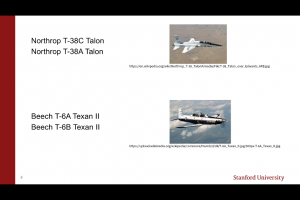
Aerobatic-capable Military Training aircraft reporting low NIC values (Image: Stanford University)
GPSJam.org is the brainchild of aviation analyst John Wiseman. The site uses crowdsourced ADS-B reports gathered by the ADS-B Exchange and displays it on a world map. Areas in yellow indicate that between two and ten percent of ADS-B reports for the day had low navigation accuracy. Areas in red had ten percent or more.
Information from the site has proved useful in identifying patterns of regular GPS jamming and spoofing in Russia and other conflict areas around the globe.
The workday patterns in Texas and Oklahoma have appeared on GPSJam.org displays since the site went live in February 2022.
GPS Interference and Aviation
Minor interference with GPS signals is fairly common. GPS jamming devices, while illegal to use, are inexpensive and easy to obtain from vendors on the internet.
Truck drivers wanting to defeat their company’s fleet tracking system, people concerned about being tracked by the government or others, even ministers trying to keep parishioners from texting during sermons – all have been known to use such devices.
Most GPS interference is unintentional. A two-year European Union study found hundreds of thousands of potentially harmful signals, but judged only about ten percent to be intentional. The rest were the inadvertent byproduct of poorly tuned electrical and electronic equipment.
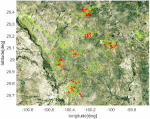
ADS-B tracks of training aircraft performing aerobatics. Red indicates low NIC value reported. (Image: Stanford University)
While most GPS interference is unintentional and localized, spurious signals powerful enough to noticeably impact airborne operations are not unknown.
In two separate incidents last year strong interference near the Denver and Dallas airports impacted air traffic, each for more than a day. The Denver incident lasted for 33 hours before authorities found the source and shut it down. Air traffic was disrupted at Dallas for 44 hours according to government sources, though researchers found the actual interference only lasted for 24 hours. The source of the disruption was never identified.
In 2019 a passenger aircraft was almost lost due to GPS interference while on approach to Sun Valley, Idaho’s Friedman Memorial Airport. As the aircraft flew a GPS-based approach in smoke and haze, the interfering signal was just strong enough to lure it off course and toward a mountain. Fortunately, a sharp-eyed radar controller hundreds of miles away spotted the problem and intervened in time. The source of the interference was never identified.
As a result of the Sun Valley incident and input from numerous aviation groups, the International Civil Aviation Organization told its members there was an “urgent need to address harmful interferences” to satnav signals.
Texas and Oklahoma Mystery Solved
A researcher at Stanford University finally solved the puzzle of the strange recurring sequence of reports from Texas and Oklahoma.
While investigating last October’s GPS interference event near the Dallas airport, PhD candidate Zixi Liu noticed aircraft outside the main area of effect also reporting low Navigation Integrity Category (NIC) values. This began before and continued after complaints from commercial airlines about GPS not being available at Dallas-Fort Worth. These aircraft were in the same general area of Texas, but far enough away that there were large areas between them and Dallas that did not contain any reports with low NIC values.
Low navigation accuracy reports displayed at GPSJam.org. in New Mexico reports were due to GPS interference from military testing. In Texas and Oklahoma, military aerobatics training likely caused reports of low navigation accuracy. (Image: GPSJam.org)
At the same time MS Liu was also investigating anomalous ADS-B reports near San Antonio and Del Rio, Texas. She discovered in all three cases the reports of low NIC values were coming from military training aircraft regularly used for aerobatics. Other aircraft nearby reported good NIC values and showed no evidence interference.
In a recent presentation to the Institute of Navigation, she postulated that Interference with GPS signals was not the cause of the low navigation integrity reports. Rather, the rapid maneuvers and unusual aircraft attitudes of aerobatics caused the airplanes’ navigation receivers to intermittently lose lock on signals from GPS satellites. This caused their ADS-B equipment to report low navigation integrity.
Having solved that mystery, Ms. Liu continues to work on her original question – identifying the source of October’s 24-hour GPS disruption near the Dallas-Fort Worth airport.
Mr. Dana A. Goward is the President of the Resilient Navigation and Timing Foundation and a former US Coast Guard helicopter pilot.