Integrated solution combines and consolidates valuable telematics data for Geotab and GM customers in Canada
Geotab Inc. has announced the availability of the Geotab Integrated Solution for General Motors in Canada. With no additional hardware installation required, the offering provides Canadian customers with a simplified fleet management platform to help businesses make better informed decisions.
With this integration, data from compatible GM vehicles, 2016 or newer, with OnStar embedded factory-first hardware can be securely transferred into Geotab’s web-based fleet management software, integrating all vehicle data into one platform, offering businesses and fleets a seamless user experience.
By enabling fleet managers to access rich proprietary vehicle data, they can generate safety reports, activity reports and measure other key metrics on one platform to help optimize fleet performance.
Users can expand the functionality of the solution further with access to the Geotab Marketplace, a growing portfolio of mobile apps and software and hardware add-ons to enable customers to tailor their fleet management solution to help meet all of their connectivity needs including improved safety, productivity and efficiency.
Parrot drones professional users benefit from an advanced control during complex fleet operations
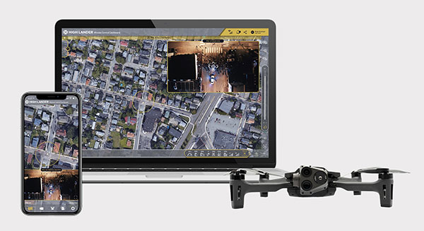
Drone company Parrot is partnering with High Lander, which provides drone fleets with autonomous flight, intelligent airspace control, and coordinated air continuity through its Mission Control platform.
Combining Parrot ANAFI USA and ANAFI platform drones with High Lander’s Mission Control software, professionals can now access drone features through an easy-to-use dashboard.
“Parrot is continuously striving to provide our professional users with extended capabilities — allowing them to rapidly adapt their drone operations to fit their changing and urgent needs,” said Jerome Bouvard, Parrot director of strategic partnerships. “Drone automation and intelligence are at the heart of our product and software developments. This new partnership with High Lander represents another step towards enhanced automation and control capability of our drones.”
Using real-time device reporting and telemetry, first responders can autonomously manage their drone fleets while performing takeoff and landing, route-planning, and other crucial tasks — all from the intuitive comfort of the Mission Control Operations Center dashboard. The software’s seamless interface paired with the ANAFI USA’s ease-of-operation and rapid deployment provide more safety for responders and allow faster intervention during critical moments. Mission Control’s customized live link generation can also provide team-members onsite with an instant view of a drone’s video feed for fast assistance during search-and-rescue missions.
For surveying and mapping missions, operators can use improved control modes including Path (which sets an automated plan including multiple waypoints, telemetric, gimbal and payload settings) and Modeling & Mapping (which allows operators to survey an area in detail) as they efficiently create 2D maps and 3D models using Parrot ANAFI’s precise GPS coordinates capabilities.
Operators can also benefit from Mission Control’s Payload Sidebar, which enables switching instantly to thermal imaging, an invaluable tool for missions in search and rescue, police pursuits, or solar panel inspections. Parrot ANAFI USA’s integrated FLIR Boson Thermal sensor and 32x zoom make it easy to identify thermal anomalies and centimetric hot spots from an altitude of up to 40 meters.
“As a hardware-free system, Mission Control is compatible with leading drone manufacturers’ solutions, now including Parrot, to provide our customers with the freedom of customizing their drone fleets with best-in-class UAVs,” said High Lander CTO Ido Yahalomi.
High Lander is working with a number of prominent organizations including police departments, sheriff’s offices, fire stations, and forestry services, and has 12 active clients who will now be able to use Parrot’s ANAFI USA and ANAFI drones in their fleets.
The High Lander Pilot app is available for download on Android and iOS systems for use with ANAFI and ANAFI USA platform drones.
For more information about ANAFI USA, contact Parrot through the ANAFI USA contact form.
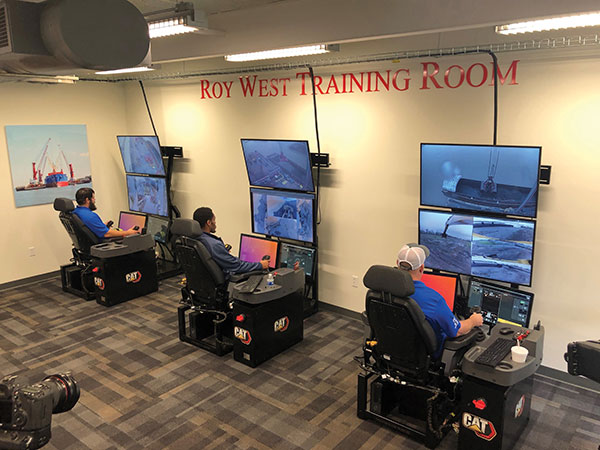
Caterpillar’s Cat Command system enables operators, including disabled veterans, to control machines in dangerous environments from the safety of a remote command center. (Photo: Caterpillar)
Caterpillar, the world’s largest manufacturer of construction equipment, has invested in the development of autonomous vehicles for more than 30 years and has the world’s largest autonomous fleet of haul trucks.
Its Cat Command suite of remote and semi-autonomous products for the construction industry helps increase safety, machine utilization and productivity for hauling, loading, excavating, drilling and dozing operations. They include onboard electronic and vision systems that allow machines to be controlled without anyone in the cab.
Options include
The line-of-sight Cat Command Console, which is supported by a shoulder harness
The Cat Command Station, which can be located onsite, for line-of-sight operation, or offsite
The semi-autonomous Cat Command for Compaction technology, which automates soil compaction to help deliver consistent results.
Over time, the company expects most of its machines to become compatible with its Cat Command technology.
Here are a few examples of how construction companies are using Caterpillar technology:
Cargo Barges. Associated Terminals, which transloads dry bulk and general cargo in the Port of South Louisiana, uses Cat Command to remotely control its small wheel loaders and excavators, keeping its personnel off the barges.
“It gives me a lot of peace of mind knowing that when we are doing our jobs, digging in these cargo holds in the vessels, my friend and co-worker is not operating the machine in the hold,” said Thomas Ramagos, a production manager for the company.
Fleet Management. Beverly Companies is a landscaping, snow removal and topsoil contractor in Chicago that owns equipment ranging from bulldozers to lawnmowers. The company uses my.cat.com and other Caterpillar fleet-management tools to track all its equipment in one place, help reduce machine downtime, manage repairs and maintenance, and order parts.
Civil Contracting. Saiia Construction Company, a civil contractor in Birmingham, Alabama, uses Cat Command to increase the safety of its employees, said Frank Montgomery, the company’s president. The material with which it deals is sometimes unpredictable, and rain events can change conditions significantly, explained Superintendent Clint Kennedy.
A remotely controlled front loader operates inside a barge. (Photo: Caterpillar)
Cat Command enables employees to work from an office trailer, rather than having to trudge through mud and muck to get to a piece of equipment. The controls in the seat are almost identical to the ones in the cab, Kennedy pointed out. Another employee can stand behind the chair and coach the operator.
High-quality cameras on site enable the operator to view the whole job site, while four on the machine enable the operator to distinguish brown dirt from red dirt and rocks from sand.
Caterpillar machines also collect massive amounts of data and transmit them over the air to the company, where they are analyzed and used in business applications.
Customers can access these data via my.cat.com and a mobile app to better understand and manage their vehicle fleets and operations, reduce fuel consumption, and improve productivity and safety. They can also access equipment locations, engine hours, parts and service records, and inspection reports.
According to Caterpillar, it had one million connected assets at the end of 2019, almost twice as many as three years earlier, and almost all its new construction machines are equipped with these connectivity systems. The Cat Productivity web-based suite of solutions works with Caterpillar machines of any age and brand. Of course, newer machines will provide richer data and more accurate results.
The acquisition will expand Verizon’s robotic capabilities to power the future of robotic automation for enterprise customers
Verizon has entered into a definitive agreement to acquire incubed IT, the creator of a software platform providing autonomous navigation tools to administer, manage and optimize mixed fleets of robots in industrial settings.
“This acquisition further demonstrates Verizon’s commitment to developing new and innovative businesses and use cases leveraging the power of 5G,” said Rima Qureshi, chief strategy officer at Verizon. “Mobile robot orchestration is a real and emerging challenge faced by enterprises today. By integrating incubed IT’s autonomous software with Verizon’s 5G platform, we will have the ability to power robotic automation at scale. This will create new opportunities for enterprise customers to better and more effectively monitor and optimize their business processes.”
Upon closing and as Verizon continues to expand its 5G coverage, capacity and mobile-edge compute capabilities, incubed IT’s autonomous software will enable enterprise customers to gain new efficiencies as they scale their autonomous mobile robot fleets.
Incubed IT’s award-winning software enables robots to localize and navigate autonomously and can be easily integrated into nearly any mobile robot. Their products include:
Smart Shuttle Navigation Toolkit: Transmits near real-time data to navigate autonomous mobile robots (AMRs)
Fleet Management Server: Manages AMR Fleet & Routing Operations
Data Monitoring and Analytics: Near real-time monitoring and advanced
reporting
“Incubed IT’s next-generation software and autonomous fleet management server are foundational components for the future of terrestrial robotics,” said Elise Neel, vice president of Verizon New Business Incubation. “When we combine incubed IT’s capabilities with the reliability, responsiveness and vast capabilities of Verizon’s 5G platform, we will enable faster, less expensive and more effective adoption of robotic automation for enterprises everywhere.”
Incubed IT’s autonomous navigation software features include:
No need to specify transport paths up front
No predefined paths
Instant rerouting
Obstacle avoidance
Safe operation in areas with other vehicles and humans
Incubed IT’s employees will join the Verizon New Business Incubation team, whose mission is to scale new automation businesses, fueled by the inherent orchestration power of 5G. The incubed IT team will continue to drive development, sales and support for its customers and suite of products across a fleet of diversified robotic partners.
“We are proud of all the incubed IT team has accomplished to get us to this point, and we look forward to expanding on our successes and capabilities,” said Stephan Gspandl, incubed IT CEO. “By joining the Verizon team, we have the opportunity to bring our software to broader audiences and to help create the future of robotic automation.”
The transaction is subject to customary closing conditions and is expected to close in the first half of 2021.
Connected transportation company Geotab has unveiled Geotab Keyless, a platform solution that integrates a secured digital key function with a comprehensive and data-driven fleet management product. Announced at the company’s third annual Geotab Mobility Connect conference, this combined solution is enabling a new class of car sharing by allowing public, corporate, leasing and government fleets to better analyze, pool, utilize and reduce their assets.
“We are proud to be the first fully-featured telematics provider bringing a unique data-driven, keyless solution to the burgeoning car sharing market,” said Christopher Mendes, VP, Electric Vehicles, Geotab. “Keyless vehicle access is critical not only for fleets seeking to improve cost and operational structures but also consumers, who are moving away from vehicle ownership and expecting an easier, more convenient driving experience.”
Car sharing on the rise
According to a 2019 research report from Berg Insights, worldwide car-sharing membership topped 50.4 million in 2018, with the report citing frontrunners including Germany, Italy, USA and South Korea. As the Latin American market continues to rapidly grow, numbers are forecast to hit approximately 227 million by the end of 2023.
Berg Insights also notes that several car makers, leasing companies and car rental companies are introducing car sharing solutions for corporate customers, with a goal to reduce mobility costs for enterprises by decreasing fleet capacity and the need for taxis and rental cars, while enabling self-booking and keyless access. Telematics and smartphones will play a pivotal role.
“Geotab Keyless is designed to enhance car sharing across every segment, including in-car delivery services in the future” added Mendes. “Keyless is particularly advantageous for electric vehicle (EV) car sharing fleets, as the solution can reliably manage vehicles’ state of charge (SOC), charging status and range remaining —a capability no other keyless hardware competitor possesses.”
Scalable platform
A simple-to-install, scalable platform solution, Geotab Keyless supports any make, model and year of vehicle that has a key fob, and provides access to the most extensive telematics data on the market including asset accounting, suitability analysis for corporate car sharing, vehicle management automation and remote vehicle management.
Fleet customers can pair their Geotab telematics solution with a vehicle reservation system software partner of their choice in order to best meet their individual business needs.
Global software partners for Geotab Keyless include Wunder Mobility, Ridecell, fleetster, Eccocar and Moove Connected Mobility. Or fleet customers can create their own reservation software using Geotab’s Keyless APIs.
How Geotab Keyless works
Once a key fob is embedded into the hardware, drivers open their third-party software app on their phone (which is integrated with their MyGeotab platform), locate the OEM button on the screen and use the features to lock, unlock and start the vehicle.
In addition to phone apps, the keyless functionality can be enabled by NFC tags and directly over the cellular connection. Over time, the solution will expand to include other applications and third-party digital key hardware solutions, as well as OEM telematics’ APIs.
“In an increasingly dynamic world, on-demand free-floating shared mobility options are enabling new and innovative business opportunities for government and commercial fleets,” said Jean Pilon-Bignell, VP of Business Development, Government and Smart Cities. “By integrating this capability with a world-class telematics platform, fleets can have confidence in the fact that their shared mobility investments are backed by real data and analytics.”
Data-driven insight
Currently equipping more than 2.1 million vehicles with its telematics technology, Geotab provides data-driven insights to over 40,000 customers worldwide and enables users to customize their solution through a suite of more than 150 hardware add-ons, software add-ins and applications available on the Geotab Marketplace.
As a result, the company processes more than 40 billion data points each day from Geotab-connected vehicles around the world. With active devices present in more than 130 countries, Geotab’s solutions are sold through its global network of Authorized Geotab Resellers.
According to a report by InForGrowth, the global GPS tracking devices market was valued at $1,567 million in 2018 and is expected to grow at a CAGR of 12.2% during the forecast period 2026.
Increasing demand for fleet telematics and affordable prices of GPS tracking devices are expected to drive the growth of the GPS tracking devices market.
However, the report says, environmental obstacles and non-standard products are expected to impede the growth of the market in the coming years.
The growth of the GPS tracking devices market is attributed to the increasing demand for fleet telematics in the transportation and logistics sector. Government authorities are making rules and regulations for fleet tracking systems in commercial vehicles for improving the safety of passengers, the report said. In addition, vehicle rental companies are deploying an increased number of GPS tracking devices in their fleets.
Next, technological advancements such as self-driving vehicles and connected car technology mainly rely on GPS-based tracking systems for improving the accuracy and reliability of navigation. According to the report, many developing countries, such as India, are focusing on the advancement of their navigation technology. The adoption of 5G communication technology will also help in the advancement of driverless cars technology, which uses GPS tracking devices for movement and route planning.
Finally, the affordability of GPS tracking devices has encouraged market growth, the report said. This in turn has increased competition between manufacturers to develop updated technology-enabled GPS tracking devices.
Via, a provider of digital infrastructure for public mobility systems, has acquired Fleetonomy, a developer of fleet management software.
Fleetonomy was founded in 2017 by CEO Israel Duanis and CTO Lior Gerenstein, with the vision of building the next generation of fleet management and optimization platforms, suitable for the challenges and opportunities that came with the shift to fleet-based on-demand services.
According to Via, the purchase accelerates its expansion beyond public transit and strengthens its ability to meet increasing global demand for efficient, flexible solutions for logistics and delivery.
Via’s technology is currently used in more than 150 cities and transit operators across the globe to power intelligent transit and delivery platforms, Via said. The need for essential transit and goods delivery has continued to grow during the COVID-19 pandemic, and Via plans to apply Fleetonomy’s technology and expertise in demand prediction and fleet utilization to advance its digitally-powered logistics solutions.
“As we continue to build the next generation of public transportation and delivery infrastructure, we are proud to partner with Fleetonomy to step into this new phase of growth,” said Via Co-Founders Daniel Ramot and Oren Shoval. “We have been consistently impressed by Israel, Lior and the entire Fleetonomy team, and by the beautifully-designed and exceptionally-engineered products they have created. We share a vision for the future of mobility and look forward to realizing this vision together.”
Helps enable state and municipal government agencies to improve fleet operations and increases operational efficiencies
Photo: THEPALMER/E+/Getty Images
Geotab, an Internet of Things (IoT) and connected transportation company, has launched its Geotab Public Works solution in North America.
The all-in-one solution offers fleet managers full visibility into the operational data of all government vehicle types on a single platform,and provides the toolsets to effectively remain compliant, reduce costs and maintain road safety.
Designed to help government agencies better manage vehicles such as salt spreaders, snowplows, street sweepers and waste management vehicles, the Geotab Public Works solution is integrated with an extensive number of spreader controllers.
The solution is built to support key government business drivers including material management, compliance, accountability and liability. Providing public works departments with improved fleet management capabilities, fleets can utilize the solution to more accurately measure material usage, such as salt, allowing government fleet managers to feel more confident that community roads are not over- or underserviced.
With Geotab Public Works, government fleets are better able to control costs while reducing the impact that excessive material usage can have on the environment.
“Empowered by an industry-leading number of spreader controller integrations alongside various geospatial capabilities, the Geotab Public Works solution is designed to help government fleets optimize both their seasonal and ongoing fleet operations,” said Chris Jackson, associate VP of Business Development, Public Works and Smart Cities. “Spreader controllers provide fleet managers with rich insights that can help government agencies ensure that their fleets are adequately servicing roads without sacrificing the health of the environment.”
Available as a configurable add-in on the MyGeotab platform, the Geotab Public Works solution allows governments, including municipalities of all sizes, to customize their database to help meet the specific needs of their fleet.
In addition, users can add further value and customization through access to the Geotab Marketplace, an extensive portfolio of mobile apps, software add-ins and hardware add-ons that enable Geotab customers to further customize the fleet management solution.
“As many governments continue to look for ways to optimize their operations, Geotab Public Works is the type of robust, scalable, secure solution that provides real value by giving government fleet managers and local constituents unprecedented visibility to their public services,” said Jean Pilon-Bignell, vice president of Business Development, Government and Smart Cities at Geotab. “With high-frequency, near real-time reporting, the Geotab Public Works solution allows governments to know where their fleets are and how they are operating at all times, enabling fleet managers to more efficiently leverage their fleet data to provide better and more transparent services to their residents.”
Radius Telematics has seen a big increase in the thefts of commercial vehicles since the coronavirus lockdown. With many offices, factories and construction sites unattended, thieves appear to be taking advantage of unattended locations.
According to Radius, vehicles and plant not equipped with GPS security devices that detect and track unauthorized movement are especially vulnerable as the thefts may go unreported for many days or even weeks.
Radius Telematics acquired two companies in 2019 that had a substantial proportion of their business in vehicle and plant security — both are reporting significant spikes in thefts.
Radius Telematics encompasses telematics brands Kinesis, UK Telematic, Plant-I, Sure-Track, CyntrX and Key Telematics. Altogether, Radius companies track more than 250,000 vehicles across the globe, with security devices fitted to 27,000 assets ranging from generators to vans, mini-diggers and earth moving trucks.
Many are equipped with Theft Recovery Trackers, small covert wireless devices with movement and tamper alarms. Once activated, the asset is automatically tracked to ensure that stolen assets are recovered quickly and efficiently.
“From security tracker alerts, we have seen a doubling in plant and van theft since the lockdown began,” said said Greville Coe, managing director of Radius Telematics. “It’s incredible that when we are all self-isolating and worrying about a deadly virus, crime is being committed while people and organizations are so vulnerable.”
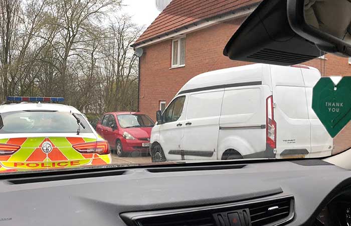
Photo: Radius Telematics
One particularly disturbing theft was of a van stolen from a hospice for the terminally ill. The incident in Coventry, UK, saw a property belonging to a hospice ransacked and the theft of a hospice van. Fortunately, the vehicle was fitted with a Sure-Track tracker previously donated by Radius Telematics and the vehicle was safely recovered after three days. The Wireless Theft Recovery Tracker allowed the Radius nationwide finder network to accurately track the movements and whereabouts of the stolen vehicle.
“It’s shocking that thieves would target a charity caring for the terminally ill in what is an exceptionally difficult time,” Coe said. “Radius Telematics tracking services remain fully operational irrespective of the travel and business restrictions imposed due to the Coronavirus crisis. We hope we can help to ensure that essential services can be delivered with minimal disruption.”
Radius Telematics is a newly branded group formed within Radius Payment Solutions. The new telematics division incorporates a number of telematics-related businesses including their own Kinesis-branded vehicle tracking and previous acquisitions including Plant-i, UK Telematics and Sure-Track.
Geotab, an IoT and connected transportation company, now offers the Geotab Integrated Solution for Ford Vehicles. Integrating Ford vehicle data into the MyGeotab platform gives fleet managers one dedicated portal with powerful tools to process data from vehicles with an embedded modem as well as those which require a third-party device.
Through this integration, Ford Data Services will securely transfer data from Ford vehicles with a factory installed modem (or Ford Plug-In Modem, where required) to Geotab’s cloud environment, eliminating the need for third-party hardware in Ford vehicles.
A business unit of Ford Smart Mobility, Ford Commercial Solutions help fleets improve their operational effectiveness by offering OEM-grade data verified by Ford engineers such as fuel use and vehicle health alerts. The Transportation Mobility Cloud (TMC), an open platform that securely manages information flow to and from Ford vehicles’ embedded modems, facilitates both new products.
Simplifying the task of mixed-fleet management, the latest solution from Ford and Geotab provides fleet managers with the ability to oversee their entire fleet in one portal while also presenting the added benefit of access to the Geotab Marketplace, a portfolio of mobile apps, hardware add-ons and software add-ins that enable Geotab customers to further customize their fleet management solution.
“Ford Data Services provides the ‘Power of Choice’ so that businesses can get manufacturer-grade vehicle information from the telematics provider of their choice, such as Geotab,” said Michelle Moody, director at Ford Commercial Solutions. “With the launch of Geotab Integrated Solution for Ford Vehicles, fleets are able to access vehicle information such as fuel usage, vehicle health and driver behavior, through the Geotab platform for vehicles with a Ford modem.”
With the solution, fleet managers can access proprietary Ford-specific data available for all Ford 2020 or newer models in the United States.
“The Geotab Integrated Solution for Ford Vehicles will allow fleet managers to benefit from the combination of Geotab’s actionable data insights and powerful rules engine with the rich diagnostic data from Ford’s factory-fitted modem,” said Geotab’s Sherry Calkins, Vice President, Strategic Partners. “This means that regardless of whether they are utilizing an embedded or externally installed telematics solution, the entire fleet can be managed from one platform.”
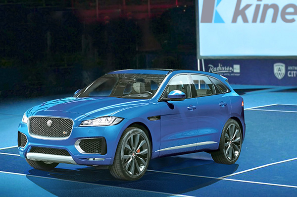
Kinesis is equipping a fleet of luxury vehicles with advanced telematics for the 2019 European Open, held Oct. 13-20 in Antwerp, Belgium.
The European Open has attracted top players including Gael Monfils who is ranked 12th in the world, Belgium player David Goffin and former Wimbledon champion Andy Murray.
Fitted to vehicles supplied by Jaguar, Kinesis vehicle tracking will provide real-time visibility of vehicle movements for logistics, security and safety. Kinesis will fit the fleet with GPS devices that transmitting accurate and up-to-the-minute vehicle locations along with driver assessment data, giving 24/7 visibility of the tournament vehicles from any internet connected device.
Photo: Kinesis
Kinesis is working with Tennium, a global tennis platform company that owns the ATP250 tournaments in Antwerp and Buenos Aires and represents a number of world-class players.
The Jaguar Land Rover-supplied vehicles will include high-end cars, limousines and minibuses and will be used to collect players from the airport and transport them between official hotels and the Lotto Arena. The fleet will also be used to transport ATP officials, invited guests and VIPs.
“Knowing where each vehicle is, where it is headed and at what time it is expected to arrive allows us to meticulously plan the transport of some of biggest names in tennis,” commented Karl Van Parys, logistics and transportation manager at Tennium. “With such high-profile sportsmen it is imperative that they arrive on court in good time and relaxed, and the Kinesis system will help us achieve this.”
The Kinesis telematics intelligence will be used by organisers to plan journeys in accordance with a demanding tournament schedule. With visibility from desktops, tablets and mobile devices, the team can respond, in real time, to changing logistics requirements as play unfolds. Kinesis can also deliver driver performance data, including speeding, harsh braking and accelerating and idling, which can be used to improve driver behaviour for health and safety.
“It is a real honour to be involved in such as prestigious event and work alongside some of the most well-known names in the world of tennis,” added Greville Coe, Group Managing Director of Kinesis. “The use of Kinesis telematics to inform decisions relating to tournament logistics as well as player safety and security, shows just how seriously the organisers take their responsibilities.”
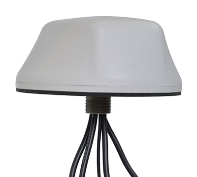
The new Mobile Mark nine-cable LTMG944 multiband antenna is designed for 5G-ready routers and gateways covering dual-carrier LTE MIMO, Wi-Fi MIMO and GNSS.
The LTM508 antenna. (Photo: Mobile Mark)
The 9-in-1 dual-carrier antenna expands Mobile Mark’s LTM series, used for public transit communications, public safety and vehicle fleet management. It contains nine separate antenna elements housed within a single antenna radome. The antenna has:
four cellular/LTE elements
four Wi-Fi elements
one GNSS element covering GPS, GLONASS and Galileo.
The LTM900 series can also be configured with fewer elements — for example, the LTMG942 contains four LTE, two Wi-Fi and one GNSS element.
The LTMG944 model can be paired with multi-connection 5G-ready routers and gateways already on the market. The cellular/LTE elements are designed to accommodate dual-carrier MIMO coverage (i.e. 2xMIMO on two different cellular carriers) or 4xMIMO for 5G.
Complete cellular coverage is offered from 694-960 and 1710-3700 MHz, with GNSS coverage on GPS and Galileo (1575 MHz) and GLONASS (1612 MHz), and dual-band Wi-Fi coverage on 2.4 and 5 GHz.
“Our new dual-carrier antenna solution series is compatible with the latest fleet management modems and routers offering dual-carrier coverage,” said Michael Berry, Mobile Mark president and CEO. “A single antenna provides MIMO coverage for each carrier.”
The antenna also provides broadband coverage. “We are happy to report that Mobile Mark’s new 9-cable 5G-ready antennas are in production today with efficient, 5 dBi gain on the FCC allocated 5G mid-bands of 3550-3700 MHz as well as being backwards compatible for other cellular frequencies,” Berry said.
The antenna is housed in the attractive, recognizable LTM radome in a choice of black or white. It is sold as a kit with 1-foot pigtails (LMR-100 except RG174 on GPS) and 14-foot jumper cables. The antenna elements fit in a compact radome that measures 5.5-inches in diameter by 2.38 inches high (140 mm x 60 mm). The LTMG944 series antennas are available as surface mounted antennas, but not as mag-mounts.
For high-vibration applications such as mining or large earth-moving equipment, Mobile Mark has developed a proprietary construction technique with superior shock and vibration test results. This option is available for the LTM944 series antennas.
The dual-carrier antenna is made in the USA, in Mobile Mark’s Itasca, Illinois, factory.”