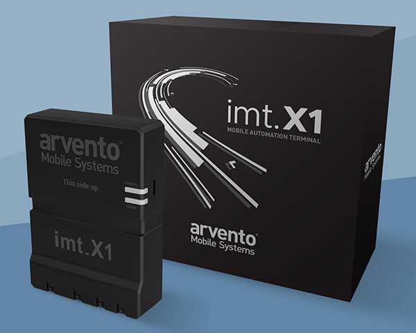
Arvento’s imt.x1 has a six-axis gyro sensor that can sense three-dimensional movement caused by emergency acceleration, panic braking and directional yaw and drift.
With connectivity options including dual CANBus and Bluetooth, the system is also eCall compatible and captures and provides data for accident analysis and other vehicle tracking functions. The system also uses the next-generation powerful Arm-based microcontroller.
This latest launch is yet another product of a successful, eight-year strategic partnership between Arvento and u-blox. “U-blox is more than a supplier,” said Özer Hıncal, Arvento’s general manager. “As a global leader in the IoT [internet of things] industry providing high-performance IoT modules, platforms and support services, u-blox is our trusted solutions partner, working closely with us to address customer demands and issues.”
As for previous Arvento products, collaboration with u-blox was a key factor in the imt.x1 product development process. The system’s high position sensitivity and accuracy are based on integration of u-blox’s 2G, 4G and 5G-ready cellular modules as well as GNSS modules.
The development of the imt.x1 aligns with Arvento’s vision and mission as a developer of advanced fleet telematics and vehicle tracking devices and will be available from August 2019.
The device combines u-blox GNSS, 4G and Wi-Fi technology, eliminating the need to equip vehicles with a separate mobile Wi‑Fi hotspot.
According to the companies, the StartLink TrackerWi‑Fi is suitable for applications for connected cars, telematics, vehicle diagnostics, fleet management, vehicle security, usage-based insurance, and rental and leasing service companies.
The internet of things (IoT) and connected-car initiatives are providing rental car companies and transportation and logistics firms with tools to track vehicles, preemptively detect and diagnose disturbances from a distance, and monitor the behavior of their drivers in real time. ERM has more than 1.8 million vehicle fleet-tracking devices deployed on roads world-wide.
As onboard Wi‑Fi becomes increasingly widespread, many companies are fitting vehicles with Wi‑Fi hotspots to offer drivers and passengers internet access. With its integrated Wi‑Fi hotspot, ERM’s StarLink TrackerWi‑Fi lets users tap into the cellular 4G connectivity to transfer telematics data to the fleet manager. This makes it possible to send real-time telematics data to the driver’s smart device or onboard infotainment system, and it also reduces the number of SIM cards needed from one per device to one per vehicle.
Sourcing the GNSS tracking, cellular 4G LTE, and Wi‑Fi technology from u-blox played a key role in achieving the device’s fast time to market. By using u‑blox’s pre-tested positioning and communications modules with integrated software, the manufacturer was able to cut the time needed for production and development by several months.
“We saw an opportunity to provide more values to our customers by adding Wi‑Fi hot spot functionality to our StarLink Tracker, our leading telematics product, but knew that we had to be quick to stay ahead of the game,” said Kfir Lavi, senior vice president of ERM Advanced Telematics.
“Our partners are always at the top of our priorities, and we are working to adapt our offerings to the market demands and the changing needs of their customers. Working with u‑blox as the provider of the positioning and wireless communication technology helped us move from concept to commercialization in under six months and provide our partners with an advanced product in a short time,” Lavi said.
“This successful collaboration demonstrates that we have evolved from a provider of individual technologies, namely GNSS positioning, cellular 4G connectivity, or short range radio communication, to a provider of solutions that bundle these technologies,” said Thomas Seiler, CEO of u-blox. “We are seeing increased demand for such bundled solutions and are convinced that the close integration of our technology portfolio offers our customers the unique ability to jump-start even challenging projects on extremely short notice.”
SmartDrive Systems, a video-based safety and transportation intelligence company, is collaborating with Geotab to provide fleets with integrated solutions that leverage the SmartDrive platform as a single on-board data collection hub.
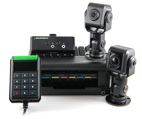
The SmartDrive SR4 video hardware platform. (Photo: SmartDrive Systems)
SmartDrive and Geotab are helping to simplify the on-board technology footprint, providing fleets the freedom to choose solutions that fit their business and their budget, and dramatically lowering the total cost of ownership.
SmartDrive offers a single integrated and aligned understanding of time, location and driver and vehicle performance to third-party applications. Fleets will be able to select solutions without incurring the additional costs associated with managing and maintaining multiple onboard devices.
“The ability to integrate and operate applications from a single data collection platform breaks through significant technology and operational barriers — unlocking efficiency gains for fleets across routes, drivers and risk,” said Steve Mitgang, SmartDrive CEO. “Collaborating with Geotab allows us to make good on the promise of convergence with a company that shares our commitment to providing open, connected and flexible solutions for fleets of every size. We believe this is a transformational shift — and it’s only the beginning of what is possible for our customers.”
With the growth of technology in the cab, fleets are struggling with how to manage the number of devices on the windshield and the connection of those devices in the vehicle.
Video-based safety cameras, electronic logging devices and advanced driver assist system (ADAS) sensors are causing fleets to look for integrated solutions that solve the hardware and data overload problem. Beyond the number of devices on the vehicle, fleets also are contending with the cost to install, maintain and train on each of these technologies. With the migration from 3G cellular networks to 4G, and resulting need to upgrade onboard hardware, fleets have an opportunity to re-think and streamline their technology strategy.
“For too long, traditional telematics systems have saddled fleets like ours with costly hardware that is expensive to maintain and upgrade, and monthly subscription costs that continue to escalate,” said Matt Penland, vice president of safety, Cypress Truck Lines. “There has to be a better way. Fleets should have the same freedom and flexibility to consolidate devices and applications that we all now have on our cell phones. The technology is available to make this possible.”
The SmartDrive platform provides a unified video and telematics data stream that can be leveraged by third parties to power their applications, the companies said. This same data stream powers the SmartDrive video safety program, ADAS and transportation analytics applications.
Through the collaboration, Geotab telematics and compliance offerings take advantage of the SmartDrive single box architecture and unified data stream, eliminating redundancy across hardware, cellular connectivity, GPS modules, connections to the ECU and cabling. It also provides data alignment across the two providers’ applications, unlocking new fleet performance insights and eliminating problematic data discrepancies.
As a result of the collaboration, fleets can benefit from:
The SmartDrive video safety program
SmartDrive SR3 or SR4 video hardware platform
“Single box” architecture enabling the convergence of data, devices and network connectivity
Analytics powered by SmartDrive SmartIQ
Geotab tracking, which delivers real-time and historical visibility to location, speed and geofencing information
Geotab regulatory compliance, including hours of service, driver vehicle inspection reports, International Fuel Tax Agreement (IFTA) recording and tax reports
Access and integration to Geotab Marketplace partners.
“Geotab’s open platform centers on a reliable, scalable and secure approach to data access for business solutions,” said Colin Sutherland, executive vice president of sales, Geotab. “We have always said that our hardware is agnostic. The SmartDrive video hardware integration is a solution that not only leverages Geotab’s platform strength to incorporate data from non-Geotab hardware, but it is a great example of telematics solutions that extend the capital investments across multiple solution providers.”
With more than three billion data points collected daily from over one million vehicles, Geotab helps companies access critical business intelligence and benchmarking data to help increase productivity, reduce fuel consumption, improve driver safety and strengthen compliance.
The integration with Geotab will be generally available early in the first quarter 2019, and the SmartDrive convergence early adopter program is in progress.
Current and prospective customers will be able to take advantage of the integration to Geotab from either the SmartDrive SR3 or SR4 platform.
Released in March 2018, the new SR4 hardware includes unprecedented compute power in a small, flexible footprint; new sensors for advanced risk identification and real-time driver-assist; innovative architecture enabling the convergence of data, devices and network connectivity; new analytics powered by SmartDrive SmartIQ; and a video safety program.
Automotive technology provider ERM Advanced Telematics has launched the StarLink Tracker with Wi-Fi, which integrates advanced vehicle tracking, driver behavior monitoring, theft prevention, Bluetooth, Wi-Fi and 4G cellular capabilities in a single device.
The company’s products have been installed in more than 1.5 million vehicles worldwide, the company said.
The StarLink Tracker with Wi-Fi is the first product under ERM’s new Wireless Connect strategy, which aims to use wireless technologies to provide its partners — vehicle fleet management companies, vehicle manufacturers and importers and car insurance companies — with a competitive edge.
The StarLink Tracker is a modular solution that is designed for installation both in vehicles on the production line and in the aftermarket, for vehicles that have left the production line. It turns any vehicle in which it is installed into a connected car.
The modularity of the product allows the addition of capabilities anytime through the use of add-on products provided by ERM or by a third party. This can be done on demand and without any need to replace the StarLink Tracker device, which keeps functioning as the central tracking and communications unit under any such solution.
The StarLink Tracker with Wi-Fi took about a year to develop, and ERM has already received its first orders to supply the product from customers in the United States, India and Australia.
The 120-gram tracker creates Wi-Fi hotspots in the vehicle for up to eight devices. It features a GPS/GLONASS/Galileo location module and an ability to navigate inside underground parking lots or in mines; a 4G cellular modem; internal antennas, emergency button support and built-in data logger.
Other capabilities are internal management of up to 500 driver IDs, remote immobilization, wireless connectivity to a wide range of additional ERM and third-party products and many other features.
As the core infrastructure for a Connected Car applications, the product can integrate to full range of the vehicle’s internet connectivity needs, which are provided by the use of the tracking unit’s SIM card without the need for any additional SIM card, the company said.
The StarLink Tracker with Wi-Fi and products that ERM Advanced Telematics will launch in the future under its Wireless Connect strategy, can be installed using the installer’s standard smartphone which communicates through Bluetooth connection in order to configure the product and perform any required adaptations. All this can be much faster compared to many other telematics devices and with much less hassle that might have arised due to the need to hook-up and hide wires.
The StarLink Tracker with Wi-Fi is also equipped with a microphone and loudspeaker to initiate and receive calls and dial emergency numbers. One application for this can be E-Call (Emergency Call), such as in the European Union or just as an Emergency Call application.
When pressing the location unit’s emergency button or immediately after an impact above a certain intensity, the unit will allows conversation between the vehicle’s occupants and the emergency center personnel, who can hear what is happening in the vehicle and identify events such as threats against the driver or accidents.
The product will also provide information about the driver’s behavior, including careless driving, accidents, off-road driving, acceleration during turns, speed violations and more, information that can be used by the manager to significantly improve fleet management capabilities, performance and can decrease operational expenses.
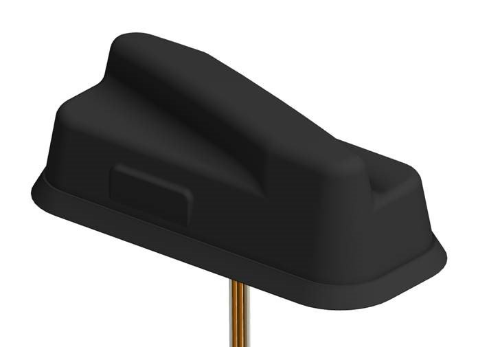
PCTEL Inc. has announced the next generation of its Trooper antenna, the company’s flagship multi-band platform for public safety fleets.
The new Trooper II provides optimal wireless communications performance through the antenna’s 4-port 4G LTE connections and 4×4 802.11ac Wi-Fi MIMO capability, the company said. It also incorporates PCTEL’s newest high rejection multi-GNSS technology for high precision tracking and asset management.
The Trooper II antenna. (Photo: PCTEL)
“The Trooper II antenna enhances PCTEL’s successful Trooper platform, with expanded multi-band RF and GNSS capability in a robust, aerodynamic housing,” said Rishi Bharadwaj, senior vice president and general manager of PCTEL’s Connected Solutions group. “Its slender new design with a single cable exit accommodates installation restrictions often encountered on modern public safety vehicles.”
“Our Trooper antennas have been broadly deployed on public safety fleets, notably in support of the leading FirstNet public safety broadband network systems. The Trooper II is also ideal for many Industrial IoT deployments,” Bharadwaj added.
The rugged Trooper II (part #GL9X1AX-TRB) features PCTEL’s new proprietary high rejection multi-band technology, which supports GPS L1, GLONASS and Galileo for high precision tracking.
In addition to public safety applications, the antenna is suitable for tracking and communications support for industrial internet of things (IoT) and other fleet management applications, including farming tractors for precision agriculture, utility service fleets and railway positive train control systems.
PCTEL will display the Trooper II antenna Aug. 6-7 at APCO 2018, Booth 1719, along with its portfolio of antennas for the public safety industry and grid testing solution for in-building public safety networks.
The Trooper II antenna is available for pre-order now. First shipments are expected in early fall.
The SensLynx GPS Management Accelerator Program (GMAP) can enable start-ups or enhance existing business portfolios with the addition of tracking solutions, the company said.
GMAP requires no upfront investment or inventory warehousing, and is structured to deliver recurring revenue via new sales channels, while also being compatible with legacy business models to capitalize on similar customer profiles.
Because SensLynx white labels its solutions under certain criteria, entrepreneurs earn significant margin on hardware sales, plus monthly subscription income from the customers they will own outright.
“We believe in the entrepreneurial spirit,” said Rob Garry, co-founder and CEO of SensLynx. “Not only does this Accelerator Program help us grow our IoT Fleet sector on a grass roots level, it inspires others to strike out on their own or expand.”
The GMAP program is built around SensLynx’s bundled solution components, which include Fleet & Asset Tracking, Electronic Logging Device, Routing Application, Video/DashCam capture and Workforce Management for smartphones.
At its heart is comprehensive fleet/asset tracking software, packed with features like data handling, parsing, database, mapping, alerting, reporting, dispatch, maintenance logging, e-logs, local posted speed limits, addressing, geofencing, interstate miles, open API-based software and more.
The complete bundled solution with software, hardware and data connectivity is packaged at one guaranteed monthly price.
Senslynx’s GMAP program includes initial training, planning for rollout, conducting telemarketing for launch, developing website content, providing custom-branded marketing materials and online demo support, accessible through the streamlined GMAP Reseller Portal where businesses can also easily manage supply chain and customer accounts.
Teletrac Navman, a global software-as-a-service provider that leverages location-based technology for GPS tracking solutions, has launched its fully integrated Driver Safety Analytics Solution.
Part of the Teletrac Navman Director platform, the safety analytics solution combines GPS tracking data and event replays, dashboard camera technology, driver scorecards and analytics on a single platform so fleet managers have all the information needed to reduce risks and implement safe driving practices across their fleets, the company said.
“I have a full view into safety and the solution makes everything fact-based. Before I had perceptions of how my drivers behave on the road, but now I have proof,” said customer Bonnie Lantz, director at P&B Transportation. “I can see training needs and, of equal importance, our drivers’ incredible defensive driving when cars around them behave erratically. Our insurance company and drivers both wanted the cameras, and I expect it will save us money and give our whole fleet a better grasp on safety.”
The Director Safety Analytics module provides insight into driver-specific and fleet-wide behavior to create a safety-focused culture, recognize and retain great drivers, and improve the insurance claims process. Features include:
The Integrated Event Viewer lets fleets simultaneously view driving event replays and unsafe behaviors on Google Maps, using GPS tracking data, and second-by-second Dashboard Camera video footage for quick response to and resolution of incidents.
Front-Facing Dashboard Cameras continuously record HD quality video footage, with recordings of all events stored in the cloud. In addition to getting a complete picture of events, footage can be used as supporting material in the event of an insurance claim and to protect against driver fault in accidents.
Driver Scorecards track and rank driver improvements over time for personalized training, in combination with event replay and live footage, and to recognize positive driver behaviors.
Reporting & Alerts measures speeding, harsh breaking, erratic cornering and other dangerous behaviors through GPS tracking and proactively alerts fleet managers. It lets fleet managers build dashboards around safety KPIs and do in-depth evaluation on fleet-wide and individual driver safety performance to easily communicate performance trends, create targeted improvement plans and build incentive programs that encourage safe driving.
“We built this solution to give fleets absolutely everything they need to build a culture of safety,” said Daren Lauda, general manager of North America, Teletrac Navman. “The high-level fleet benchmarking is easy to drill down into to understand how individual drivers are performing. Add in the integrated telematics and corresponding video footage and fleet managers have a complete, real-life picture of safety to fuel individualized training, track progress and protect their drivers in incidents.”
Airgain Inc., a provider of advanced antenna technologies used to enable high-performance wireless networking, has released its Ultramax MIMO 9-in-1 antenna, which can receive multiple GNSS signals.
Designed for public safety fleet management, it provides high rejection GNSS technology with coverage for multiple satellite systems including GPS, GLONASS, Galileo and BeiDou.
The new Ultramax MIMO 9-in-1 antenna will help improve public safety and fleet solutions with enhanced Wi-Fi capability, the company said. It includes 6 x 6 MIMO Wi-Fi, dual LTE and multi-GNSS technology antennas in a single enclosure.
MIMO — multiple input multiple output — is used within LTE to provide better signal performance and higher data rates. With integrated 6×6 Wi-Fi antennas, the antenna provides support for full high-definition (HD) streaming video and other high bandwidth applications.
The antenna is the first in an Airgain series designed to support state-of-the-art communications technology in fleet routers, including the Cradlepoint IBR1700.
The Ultramax MIMO 9-in-1 antenna is equipped with nine ports, supporting tri-band Wi-Fi, LTE/MIMO (including Band 14 for FirstNet) and GNSS. With a single compact footprint, the antenna avoids multiple mounting and cable entry points.
“Technology advances in routers, including enhanced Wi-Fi and expanded MIMO LTE, require enabling antenna technology to deliver an optimized end user experience,” said Reed Pangborn, vice president of channel sales for North America. “We designed a new antenna to support the fleet management applications required in today’s evolving mobile environment. The Ultramax MIMO 9-in-1 antenna demonstrates our commitment to providing leading antenna solutions for our mobility customers covering a wide range of vehicles, including police, fire, ambulance and other fleet assets.”
The Ultramax MIMO 9-in-1 antenna complements Cradlepoint’s IBR1700 and supports all six of its Wi-Fi ports.
Airgain will unveil the new antenna at the Cradlepoint Global Partner Summit in Scottsdale, Arizona, April 11-12. The Ultramax MIMO 9-in-1 antenna will be available to order starting in June.
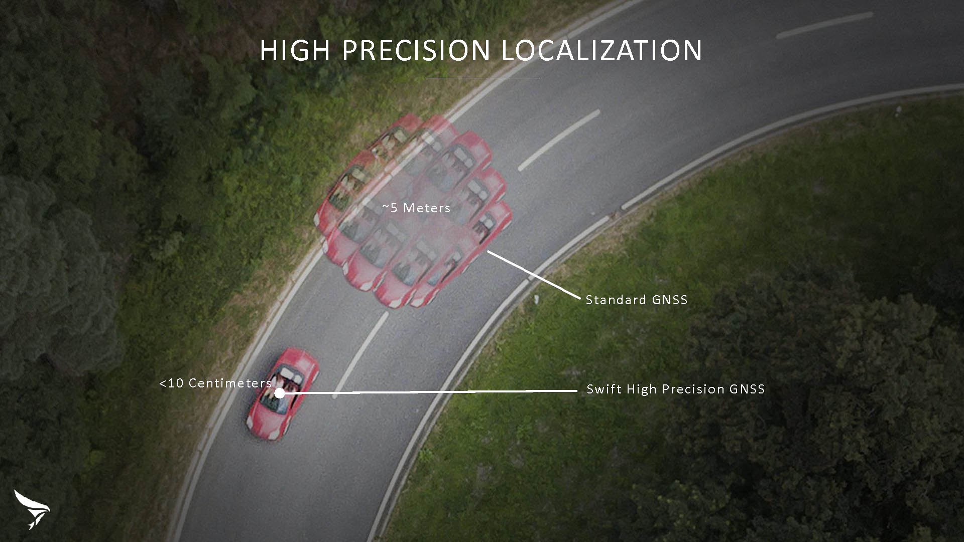
Swift Navigation has released Skylark, a cloud-based GNSS corrections service delivering centimeter-level accuracy without deploying and maintaining a GNSS network. Skylark targets autonomy applications at scale and enables high-precision positioning for mass market automotive and autonomous vehicle applications.
Skylark works with both of Swift’s multi-band, multi-constellation GNSS receivers, the Piksi Multi and the Duro ruggedized industrial receiver. Swift added GLONASS support in its 1.4 firmware upgrade, announced earlier this month, and aims to include Galileo and BeiDou in the near future.
Previously known as a hardware company, Swift Navigation appears to be shifting its focus a bit, including an Internet-delivered service in addition to its GNSS receivers. It has recently focused more closely on the automotive sector; it also has customers in drone technology, robotics and precision agriculture.
Its new platform for high-precision GNSS navigation of autonomous vehicles, via Internet connectivity, Skylark delivers fast convergence times measured in seconds, using positioning algorithms to provide a continuous stream of data to individual devices from the cloud. The data stream allows for quick and robust positioning and high reliability and availability, even in challenging environments, according to the company.
The Skylark service offers accuracy at the centimeter level. (Image: Swift Navigation)
Critical requirements for real-time absolute localization through GNSS for the automotive sector, according to Fergus Noble, co-founder and CTO of Swift Navigation, are:
high accuracy; centimeter level
availability; fast convergence, measured in seconds
integrity
scalability to support a large vehicle population
low cost.
Internet-Delivered via Cell Network
The last two requirements are fulfilled by the cloud-based approach. He characterized Skylark as a hybrid of RTK (Real Time Kinematics) and PPP (Precise Point Positioning) approaches augmented by Swift’s intellectual property, with corrections delivered over the Internet as provided by the cellular network, which he described as “robust to outages.” Cell coverage along road networks is good, Noble asserted, and 5G applications are increasing that coverage and will further enable connected vehicles. Automotive OEMs are comfortable with the level of cell coverage for this application, according to him. There has been testing to show robustness in most rural areas, and network operators are dedicated to increasing this.
“Skylark operates like a utility,” said Noble. “It is a simple, low-cost Internet data stream that provides customers with a complete high-integrity GNSS solution. Simply supply a Swift receiver with power and Internet connectivity and get real-time corrections for highly-dynamic GNSS applications.”
To realize the Skylark service, the company hired a team of cloud-based engineering experts who had a role in building Amazon and Oracle critical infrastructure. Swift Navigation is initially launching only with its own devices, but is making the service publicly-available for any customer in any vertical requiring precise positioning. “Every car company is building in autonomous functionality,” noted Noble, making clear who the company is ultimately targeting.
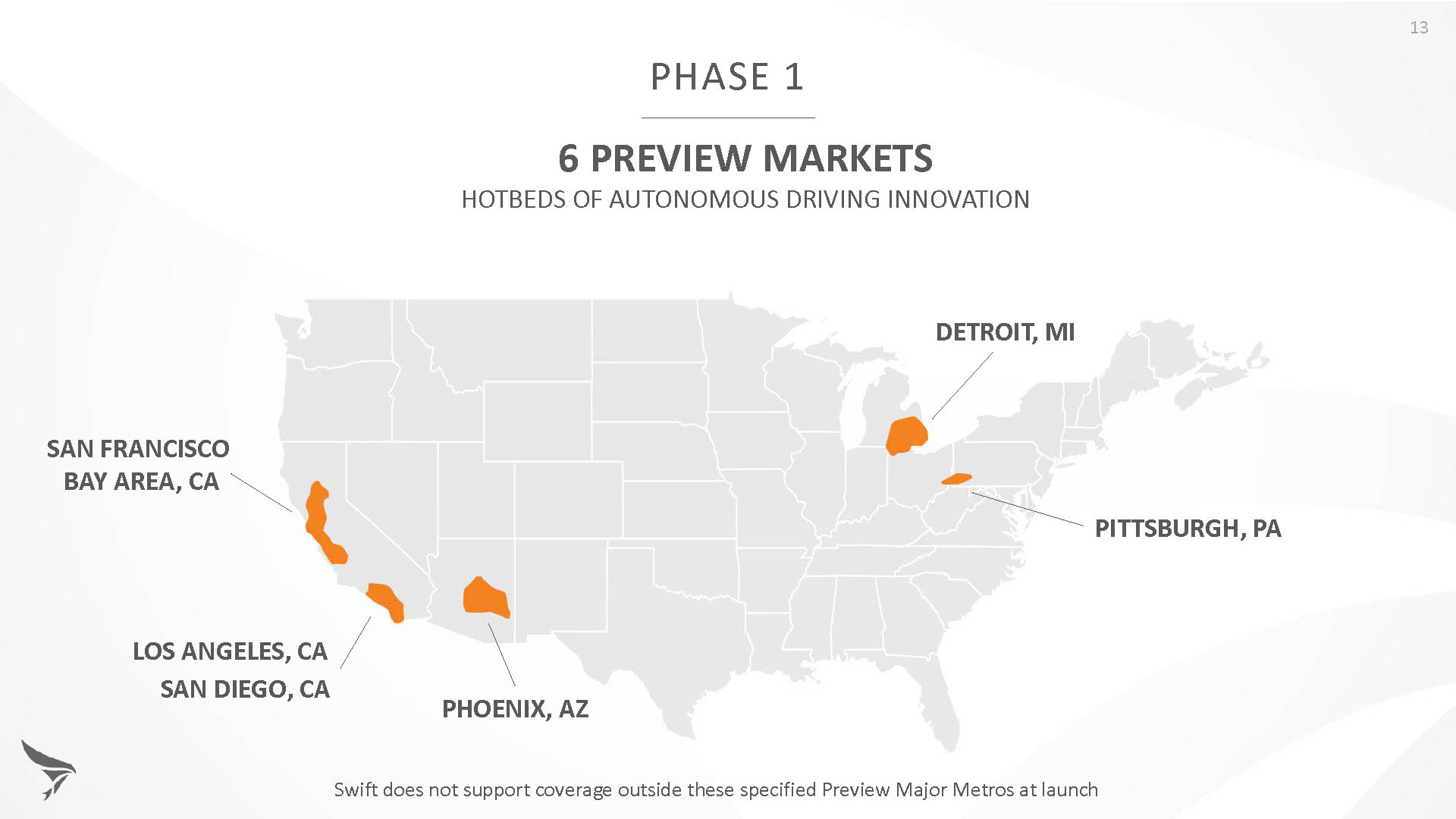
Skylark is currently offered in six metropolitan markets. (Image: Swift Navigation)
Swift has been working with beta customers for more than a year and is now previewing the service to all customers in six metropolitan markets: the San Francisco Bay Area, Los Angeles, San Diego, Phoenix, Pittsburgh and Detroit. The company envisions full contiguous U.S. and ultimately global expansion. Customers in preview areas with Swift receivers can sign up for Skylark and immediately start receiving corrections.
The service maintains low bandwidth to save on data costs and is offered with a free 30 day trial and flexible pricing plans. Skylark’s pricing structure includes a monthly plan and an annual plan. Enterprise pricing is available for volume orders.
Voyage Self-Driving Car Active Service and Coming Expansion
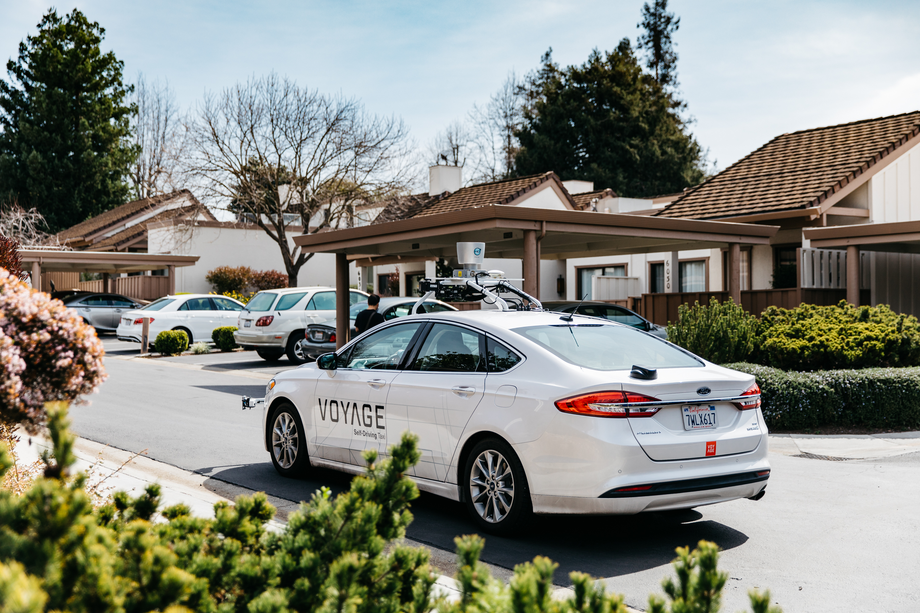
An early beta user of the service, Voyage deploys self-driving taxis in private communities across North America. “Skylark and Piksi Multi are working safely and efficiently in a real-world application today at The Villages, a retirement community in San Jose, California,” said Oliver Cameron, co-founder & CEO of Voyage.
Voyage incorporates Skylark GNSS corrections in controlled road networks in private communities. (Image: Swift Navigation)
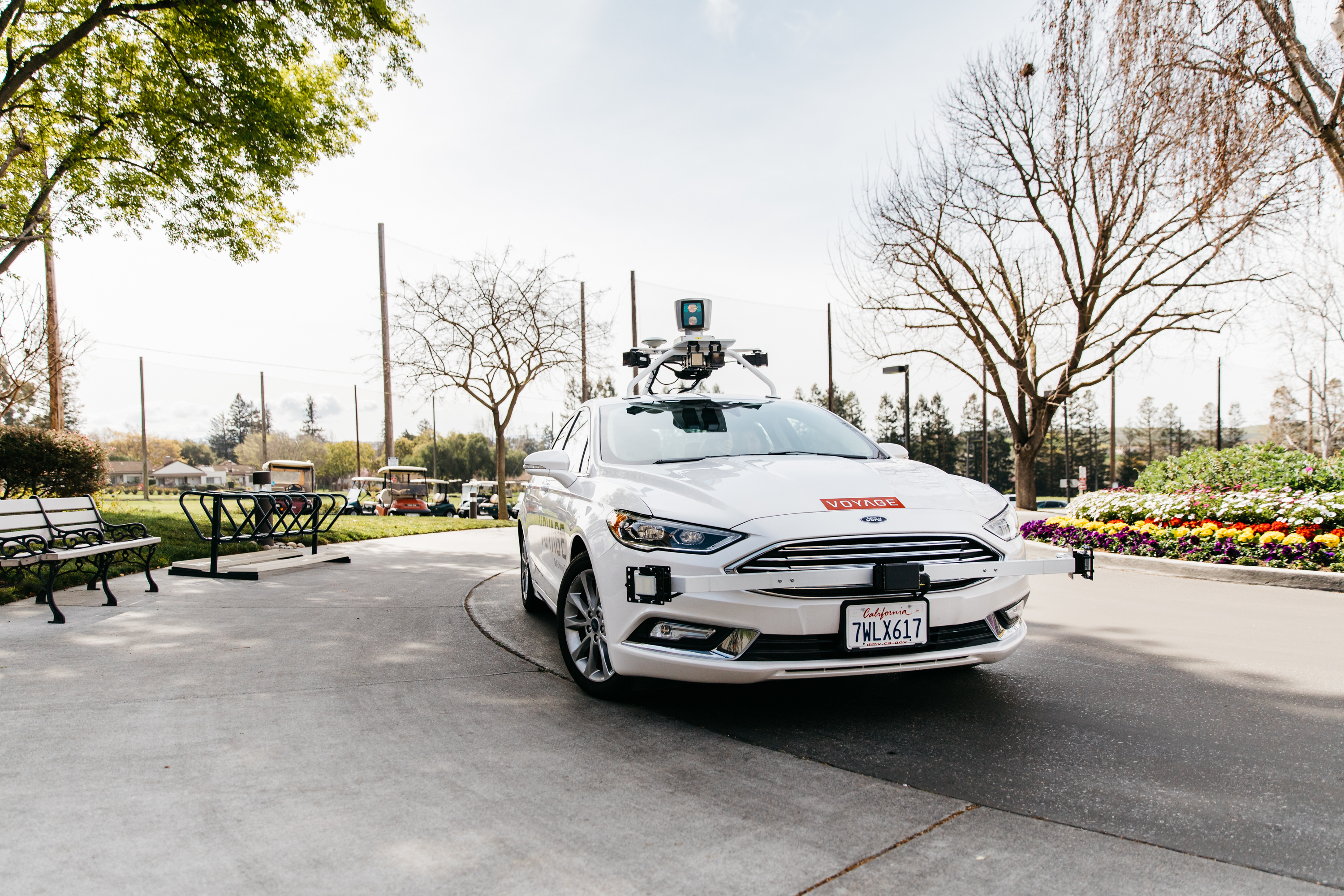
Voyage’s passenger cars carry a roof-racked suite of sensors: the Swift Navigation Piksi Multi GNSS receiver, LiDAR, cameras, radar, and an inertial measurement unit. A computer in the trunk integrates all sensor signals and uses the car’s CAN bus to operate steering, braking, and other functions. An operator sits behind the wheel at all times, sometimes with a co-pilot: one to watch the road ahead, and one to watch the software. “Safety is our first priority,” said Cameron.
The service is especially valuable to customers with mobility limitations that might prevent them from walking to an event or moving within the community. (Image: Swift Navigation)
The Voyage fleet stays within the bounds of a given community, where all roads have been precisely mapped, speed limits are lower and traffic patterns are more clearly defined than in metropolitan cities. The first in the San Jose area serves private community of more than 4,000 residents, with a 15-mile road network. Today, residents are able to summon a Voyage self-driving taxi using a smartphone app and have a ride waiting at their front door. This service is especially valuable to customers with mobility limitations that might prevent them from walking to an event or moving within the community. Voyage takes residents of The Villages to and from the gym, to visit with friends, to the golf course and to community center events.
Image: Swift Navigation
Voyage will next deploy the Swift product suite in its upcoming deployment launching to 160,000 retirees at The Villages complex in Florida, over a road network of 750 miles. It is currently in a “Q/A” testing phase on that site, working the technology and the local mapping through their paces.
Sygic is partnering with innovative addressing system what3words.
According to Sygic, its business solutions and consumer apps are used by more than 200 million drivers and 2,000 fleets worldwide including Amazon. Sygic is also the first GPS app to partner with Ford.
The partnership will initially focus on Sygic’s business solutions for taxi, public transport, delivery and construction clients with the aim of a wider integration into Sygic’s commercial products. Clients will be able to turn on three-word addressing within their existing solutions in the coming months.
what3words is a location reference system that has divided the world into 57 trillion 3 x 3-meter squares, each with a unique three-word address. For example, “///droplet.outings.panel” will take you to the front door of Sygic’s headquarters in Bratislava.
“Sygic is committed to exploring the boundaries of navigation, a philosophy that has directly contributed to our enduring reputation as the leader in navigation,” said Martin Strigac, Sygic CEO. “what3words is the simplest way to talk about location and its rapid adoption across sectors means it is quickly becoming a standard. To get from A to B,, you need a map, navigation and to know precisely where A and B are. With what3words, we can now offer a world-class solution across all of these.”
“In-car navigation relies on an antiquated street and postal address system that is no longer fit-for-purpose,” said Chris Sheldrick, CEO and co-founder of what3words. “Poor addressing leaves drivers frustrated and means businesses waste millions every year. We are delighted to partner with Sygic to offer their business customers a more efficient solution to the last-mile challenge.”
Sygic featuring what3words will be showcased at the Post & Parcel Conference, being held March 20-22 in Berlin.
By Jason Penkethman, Chief Product Officer at Spireon
Fleets looking to take their operations to the next level look to GPS solutions for the obvious benefits — driver/vehicle location tracking, driver behavior monitoring, improved efficiency — and some that are not so obvious, such as making a positive impact on the environment.
“Going green” can be an arduous task, requiring constant calculations and adjustments to ensure that a fleet’s reduced environmental impact doesn’t negatively affect normal operations.
Fortunately, GPS fleet management solutions have come a long way and go far beyond simple geolocation. We live in an age where technology empowers fleet managers to go green – both environmentally and fiscally. And with effective communication and transparency, even drivers who once may have perceived fleet tracking as “big brother” are now seeing how joining the green initiative puts green in their own pockets.
The Case for Smarter, Eco-friendly Workdays
No matter the size of the fleet, reducing unnecessary drive time saves time, gas, and reduces carbon footprint. When last minute changes or emergencies arise, fleet tracking allows managers to dispatch the nearest driver for faster, more effective resolution. Fleet tracking also allows better planning of a driver’s day with proximity as a guide.
Image: Spireon
Eliminating Paper Waste. To properly manage a fleet, there is a seemingly endless stream of logs and diagnostics for drivers, cargo, vehicles and more. Implementing GPS tracking will cut back on the paperwork for managers and drivers alike by automating what once were manual processes and making compliance with new federal regulations such as the ELD mandate and the Food Safety Modernization Act a breeze.
Cutting Unnecessary Emissions. Idling and abrupt acceleration or braking are the biggest culprits of wasting gas and producing excess emissions. Thanks to GPS logging, these can be avoided as feedback is provided to fleet managers and drivers, allowing active awareness for better driving habits.
Better Maintenance, Better Mileage. Second to employees, vehicles are a fleet’s most important asset, and both need proper attention and care to succeed! While drivers can tell a fleet manager what they need, many vehicles won’t until it’s too late. With modern GPS devices, diagnostics are constantly run, keeping fleets informed and instantly aware of upcoming maintenance or surprises to keep drivers safe and vehicles running at maximum efficiency.
Creating Driver Advocates
While the benefits of GPS fleet tracking seem clear, overcoming driver apprehension sometimes causes pause for the business owner looking to implement a solution.
However, drivers can become GPS’ greatest advocates with clear communication and transparency. It’s important to explain that GPS tracking works to a driver’s advantage when there are records of driver performance in the event of an accident, medical emergency or crime.
Fleet managers can use the data to support drivers if they are accused of wrongdoing by customers or an insurance company. Additionally, the system can be used to offer incentives including higher base pay, recognition or bonuses to the best performing drivers.
Fleets should convey that the main goal of GPS is not to point fingers at drivers or to spy on them, but rather to make the business enterprise more efficient and competitive.
Part of the process necessarily means an overall improvement in their working conditions such as not having to call them all the time to keep track of their positions, sending the closest convenient driver to a location, establishing routes and schedules that are manageable and — yes — monitoring their behavior.
This, however, is an incentive to keep drivers under the speed limit and make them feel more responsible — not least, protecting against legal and safety issues. In our experience, good employees have no problem with accountability and, in fact, welcome it as it sets them apart from less productive co-workers.
Greenery on the Scenery
Fleet tracking also helps to explain the savings in company costs made on fuel, maintenance and administration jobs.
Fleet managers should explain to drivers how the new process can generate bonus programs, reduce customer call-backs, cancellations, complaints and paperwork (for timecards) and improve upon driver training.
GPS will make for a better company with benefits everyone should realize and readily appreciate. The healthier the company, the more secure the jobs within it. Everyone benefits from a fatter bottom line, and job security is nonexistent without profitability. Helping drivers to understand why the fleet is adopting the solution will help recruit them toward a positive outcome.
Whether a fleet business is interested in going green for the environment, or for its own profitability, GPS tracking solutions — and gaining driver buy-in — create a powerful catapult to achieving goals rapidly and effectively.
Jason Penkethman is chief product officer at Spireon and is responsible for leading innovation in the company’s products and platform, and creating vehicle connectivity solutions to maximize customer value.
GPSengine, a hosted platform service provider in GNSS, telematics, IoT and tracking, named Jointech as an official Platform Connect partner.
With support built into Platform Connect for Jointech’s tracking devices, customers can take advantage of the combined offerings for fleet tracking solutions.
With a focus on personal tracking, vehicle and fleet tracking, combined with nine years of research, design and tracking device manufacture, Jointech has devices for many industry needs, including remote fuel management systems, container monitoring and fuel level sensors.