Tag: GIS

  • Latin America Sanitation Company Goes with ProMark

    Photo: Saneamento Basico do Estado de São Paulo (SABESP)Saneamento Basico do Estado de São Paulo (SABESP), a Brazilian water and sewage collection utility owned by São Paulo state and Latin America’s largest water company by market capitalization, has selected Spectra Precision ProMark 120 and 220 GNSS receivers to assist in gathering the geographic location of all SABESP network assets and the location of all customers.

    SABESP provides water to more than 28.7 million customers, or 67 percent of the population of São Paulo state. Water loss due to leakage in the SABESP network is a significant problem. The biggest reason behind water loss is leaks in the network; additional factors include sub-metering, caused by low water pressure; unauthorized consumption; and fraud. 

    Improving water management, recovering lost revenue and improving the quality of the customer experience is a priority for SABESP, Spectra Precision said. To help improve revenue generation and reduce water loss, SABESP developed two projects: LigGeo, to geo-reference the water meter location of approximately 4.8 million SABESP customers; and CadGeo, to geo-reference and register the location of the SABESP water and sewage network infrastructure.

    According to Marcos Almir, sanitation systems analyst for the metropolitan department of development and management of SABESP, the twin projects of LigGeo and CadGeo were motivated by SABESP’s desire to improve productivity and competitiveness. “We created an innovative GIS effort to geo-reference and register SABESP distribution networks and buried assets. Tests showed the technical feasibility of using ProMark GNSS receivers and collectors with NTRIP technology to efficiently and effectively register all SABESP equipment in real time with geo-referenced attributes connected to the technical and commercial enterprise systems to optimize processes and reduce costs.”

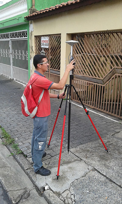
    To implement the LigGeo and CadGeo projects, SABESP purchased 50 ProMark 120 and 220 GNSS receivers from Hezolinem Equipamentos Topograficos, Spectra Precision’s Brazil dealer. Both SABESP technicians and outsourced service providers will use the receivers.

    ProMark 120/220 GNSS receivers were chosen for their multiple advantages: They could be purchased as rovers only; they could run LigGeo and CadGeo proprietary software; they are compatible with local third-party networks, including CEGAT, Brazil’s largest private RTK geodetic base network, that delivers RTK network corrections enabling real-time accuracy of less that 20 cm; and they offered direct two-way 3G communication of information with the SABESP central cartographic base raster files.


  • POB Magazine to Present Top 100 Project at MAPPS/NSPS Conference

    POBTop100InsideLogoPOB (Point of Beginning) magazine is conducting a surveying and mapping market study that will rank the top 100 companies based on total geospatial revenue for 2014.

    Michael Anderson, editor of POB, will be presenting the “POB Top 100″ project at MAPPS and the National Society of Professional Surveyors (NSPS) national surveying, mapping and geospatial conference, Collaboration: The Map of the Future, to be held April 13-16 at the Hilton Crystal City in Arlington, Va.

    Rankings will be based on total revenue from surveying, aerial mapping, geospatial imagery, 3D modeling, BIM, GIS/IT, underground mapping and other geospatial services.

    “Collaboration is key to success in the geospatial community,” said John Palatiello, MAPPS executive director. “We’re pleased POB has chosen this forum to help launch this important project.”

    Collaboration: The Map of the Future will bring together associations, professional societies, companies and government agencies in the surveying, mapping and geospatial fields. The event hopes to bridge gaps between government agencies and the private sector, as well as explore different disciplines in the community. It also will prove a forum for discussions on best practices, technology, issues and policies.

    The conference features a “conference within a conference” format, in which participating organizations will hold respective meetings and sessions.

    “Surveyors have long relied on POB as a major source of news and information about the profession and its market study and Top 100 listing will be a significant contribution,” said Curtis W. Sumner, LS, executive director of NSPS.

  • Airbus Imagery to Help Vanuatu in Wake of Cyclone

    Port Vila, the capital of Vanuatu, viewed by Pléiades satellites, before Cyclone Pam.
    Port Vila, the capital of Vanuatu, viewed by Pléiades satellites, before Cyclone Pam.
    Port Vila, the capital of Vanuatu, viewed by Pléiades satellites after the passage of Cyclone Pam.
    Port Vila, the capital of Vanuatu, viewed by Pléiades satellites after the passage of Cyclone Pam.

    Following Cyclone Pam, Airbus Defence and Space has acquired Pléiades and SPOT 6 and 7 imagery over the island nation of Vanuatu to support the International Charter and Copernicus Emergency Management Service.

    The data acquired will assist in assessing the damage and help rescue organizations in the delivery of humanitarian aid.

    The before and after Pléiades images over Port Vila, that can be downloaded here, show the devastation caused by the cyclone. The “before” Pléiades image was acquired on April 9, 2014, and the “after” Pléiades image was acquired on March 16, three days after the Cyclone hit Port Vila.

  • MemSQL Brings Geospatial Analysis to In-Memory, Distributed Databases

    MemSQL, which specializes in real-time databases for transactions and analytics, has announced new geospatial capabilities for its in-memory, distributed SQL-based database. By bringing together geospatial and operational data in the same high speed database, customers can achieve unprecedented agility for geospatial analysis, MemSQL said.

    Unlike segregated solutions, MemSQL integrates geospatial data as a primary data type, making it as easy to use and operate at scale with as much speed and high throughput as any other class of data.

    Previously, enterprises were forced to segregate their geospatial data into separate data stores. With the rise of IoT and mobility, nearly all data is location-specific. As data volume increases, maintaining geolocation information outside of the primary datastore leads to longer latency and synchronization challenges.

    By integrating geospatial functions, MemSQL enables enterprises to achieve greater database efficiency with a single database that is in-memory, linearly scalable and supports the full range of relational SQL and geospatial functions. With MemSQL, geospatial data no longer remains separate and becomes just another data type with lock-free capabilities and powerful manipulation functions.

    Taxi Scenario with Esri. Working with MemSQL and Apache Spark, Esri analyzed data compiled from 170 million real-world New York City taxi rides around the GPS coordinates of pickups and dropoffs, as well as distance and travel time. Slicing by hour of the day, Esri can calculate the average speed of a taxi ride and find the best and worst places for traffic jams. Slicing by day of the week, the ebb and flow of traffic during workdays and weekends becomes visible.

    For a city planner, this data insight can be used to redirect traffic at specific times in an effort to unclog traffic congestion. For the taxi business, this data can improve efficiency with supply and demand of cabs during times of high or low traffic for any given region.

    “MemSQL is enabling companies to consolidate many niche solutions into fewer, more capable multi-purpose solutions. By making geospatial data a primary part of in-memory, operational databases, our customers can rely on one solution to make their data more valuable,” said Eric Frenkiel, MemSQL co-founder and CEO. “We’re delivering on our promise of easy access to database innovation and are quickly becoming the go-to-company to help enterprises operationalize analytics.”

    MemSQL will showcase the MemSQL, Apache Spark and Esri demonstration at Spark Summit East 2015 on March 18-19 at The Sheraton New York Times Square Hotel. Visit MemSQL at Booth 13 during show expo hours.

    The early access MemSQL geospatial capabilities are available now and will be generally available in calendar Q2. Read the technical blog post here.

  • PocketGIS for Android Now on Available

    Pocket Systems Ltd. has released PocketGIS for AndroidPocketGIS is a professional mobile geographical information system for field data capture and surveying, which can capture and edit map geometry and enter data using forms.

    PocketGIS runs on Android 4.0 and later and is designed for tablet and handheld screens.

    GPS/GNSS. PocketGIS can be linked to a device’s internal GPS or GNSS receiver, or an external receiver via Bluetooth. This provides real-time location tracking and data capture. The GPS position is projected to the chosen coordinate system in real time offering instant verification of survey results.

    The GPS trail function specifies a time or distance interval to automatically create points from the current GPS position. This let’s users capture points automatically while walking a line or route. Advanced settings allow filtering of GPS quality to ensure the accuracy of captured points. Users can also take an average of a number for GPS position readings and compensate for antenna heights. National grid datum corrections are supported, and these are added on request (such as OSTN02, ETRS89, RH2000 and OSGM02).

    PocketGIS can be connected to a laser rangefinder or total station and provides a comprehensive set of laser survey functions. The laser functions integrate with GPS to survey offset positions and calculate height differences. Photographs can be taken from within the data-collection form using the device’s built-in camera to link the picture to captured points, lines or areas.

    Edit, Measure, Search. Users can tap on points, lines areas or text (features) to display and update information. Users can measure distances or areas and display grid references, move points and edit lines, and search for data by type or value.

    Data Exchange. PocketGIS can import and export data from cloud services such as Dropbox or Google Drive or via email. Shape, Comma Separated Values (CSV) and TIFF raster are supported. Additional formats will be supported in the future. Users can specify capture features, design data capture forms and customize imported data from within the application. No additional software or servers are required.

    PocketGIS was first released in 1997 or the Newton MessagePad. Having run on a succession of Windows CE devices, PocketGIS has evolved again and is now available for Android.

    For more information and a demo version of the software, go to http://www.pocketgis.com/android.

  • DigitalGlobe Makes Available 30-cm Satellite Imagery to Customers

    DigitalGlobe-satellite-imagery-W

    DigitalGlobe is making available its 30-cm satellite imagery products. Access to the high-resolution commercial satellite imagery captured by DigitalGlobe’s WorldView-3 satellite will improve decision making, enable more efficient operations, and enhance a variety of applications for customers in the civil government, defense and intelligence, energy, mining and global development sectors.

    In addition, many customers who previously relied on aerial imagery can now benefit from the improved economics, global availability, and faster refresh rate that DigitalGlobe can provide with its 30-cm satellite imagery, the company said. Imagery of this resolution was previously only available from aerial platforms, which are difficult, costly, or impossible to access in many parts of the world.

    DigitalGlobe’s 30-cm imagery products are also a rapid and affordable alternative in locations where aerial imagery is readily available. New imagery orders can be delivered on timescales of days or weeks, as opposed to months, in many cases, and customers can also have access to a rapidly growing volume of available 30-cm archive imagery.

    The suitability of 30-cm satellite imagery for aerial imaging applications is confirmed by the National Imagery Interpretability Rating Scale (NIIRS), which is used by the imaging community to define and measure the quality of images and performance of imaging systems. DigitalGlobe’s 30-cm imagery achieves a rating of NIIRS 5.7, meaning it can resolve objects on the ground such as above-ground utility lines in a residential neighborhood, manhole covers, building vents, fire hydrants, and individual seams on locomotives.

    “DigitalGlobe’s WorldView-3 satellite data is the highest quality satellite photo data that PhotoSat has ever processed,” said Gerry Mitchell, president of PhotoSat, a satellite elevation mapping provider for energy, mining and engineering firms. “In one test, an elevation mapping grid extracted from stereo WorldView-3 satellite photos matched a highly accurate LiDAR elevation grid to better than 15 cm in elevation. This result takes satellite elevation mapping into the engineering design and construction markets and directly competes with LiDAR and high-resolution air photo mapping for applications like flood plain monitoring.”

    The DigitalGlobe’s WorldView-3 commercial imaging satellite is capable of collecting imagery with 30-cm ground sample distance — five times the detail of the company’s nearest competitor. The satellite also features unique shortwave infrared (SWIR) capabilities that will enable new applications such as seeing through smoke and haze, identifying minerals and manmade materials, and assessing the health of crops and vegetation.

    The SWIR imagery that the satellite collects has never before been available to commercial customers with this level of spatial and spectral resolution, and it will provide unique value to users in the energy and mining industries, as well as others, DigitalGlobe said. DigitalGlobe also launched a beta program for 7.5 m SWIR imagery, working with partners, customers and users to explore new uses for this capability.

    “Companies should be exploiting the competitive advantages of the WorldView-3 data to look for potential ore-related alteration that will have been missed by the previous satellites used for alteration mapping,” said Dan Taranik, managing director of Exploration Mapping Group, a service provider to the global mineral exploration industry. “Detailed inspection of remote areas on the peripheries of alluvium or younger volcanics would be a competitive advantage that could help reveal concealed deposits.”

  • U.S. Senators Introduce Bipartisan Geospatial Data Act

    United States Senators Orrin Hatch, R-UT, and John Warner, D-VA, have introduced the bipartisan Geospatial Data Act in the U.S. Congress.

    “The federal government wastes vast amounts of taxpayer dollars by not properly managing and coordinating our federal investments in geospatial data,” Sen. Hatch said in a press release. “This common-sense legislation will improve coordination, reduce duplication and promote data transparency.”

    “Geospatial data has endless possibilities for transforming both the private and public sectors — from helping local governments develop emergency preparedness plans to fueling the creation of apps that let you find parking spots, restaurants, and even homes for sale based on where you’re standing,” said Sen. Warner. “The federal government is the largest purchaser of geospatial data but some very basic questions about how and where agencies are already investing in this data can’t be answered. Our bill would bring transparency and accountability to the collection of this data and ensure that taxpayer dollars are not being wasted on duplicative efforts.”

    The federal government has recognized the need to organize and coordinate the collection and management of geospatial data since at least 1990, when the Office of Management and Budget (OMB) most recently revised Circular A-16 to establish the Federal Geographic Data Committee (FGDC) and to promote the coordinated use, sharing, and dissemination of geospatial data nationwide. Unfortunately, the progress made over the last two decades has been inadequate, according to a statement by Sen. Hatch. “The federal government needs to improve management of geospatial data across the board,” the statement said.

    The Geospatial Data Act is designed to codify and strengthen OMB Circular A-16 and require federal agencies to implement international consensus standards, assist in eliminating duplication, avoid redundant expenditures, accelerate the development of electronic government to meet the needs and expectations of citizens and agency programmatic mandates, and improve the efficiency and effectiveness of public management.

    Additionally, the bill is intended to provide a clear definition for geospatial data and metadata, will require an accounting of the costs associated with the acquisition or creation of geospatial data, and will improve government transparency and availability to public information.

    In February, the Government Accountability Office published its third report on the issue, titled “Geospatial Data: Progress Needed on Identifying Expenditures, Building and Utilizing a Data Infrastructure, and Reducing Duplicative Efforts.” The report outlines the intrinsic value of geospatial data, and recommended various measures for better coordination of geospatial activities.

    The leaders of national geospatial organizations applauded the bill. “People believe that the United States of America has a robust system of maps and digital data. We don’t, but we should,” said Shelby D. Johnson, president of the National States Geographic Information Council (NSGIC). “The federal government was never given the tools to do the job right. This act is a good step toward solving the problems, and our members strongly support it. We also applaud Senator Hatch and Senator Warner for their foresight in dealing with this problem.”

    “GIS data is an important tool for counties when it comes to making land use decisions, maintaining infrastructure, and responding to emergencies,” said Matthew Chase, executive director of the National Association of Counties. “We support this bill because counties need accurate, modern mapping data to perform key duties and deliver services to their residents. We commend Senators Hatch and Warner for introducing this legislation and urge their colleagues to join them in supporting it.”

  • Nat Geo to Offer Trail Maps on Avenza PDF Maps App

    Joshua-National-Park_800

    On the 100th anniversary of National Geographic’s Cartographic Division, National Geographic Maps will make available hundreds of maps from its Trails Illustrated line through Avenza Systems Inc.’s PDF Maps app.

    The addition of these outdoor recreation maps in North America augments the PDF Maps app digital map database by incorporating trail maps. It also increases National Geographic Maps’ reach within the mobile consumer market, giving more consumers access to the Trails Illustrated line. Trail maps from many of America’s national parks have already been uploaded to the app, including Yosemite, Yellowstone, Grand Teton, Zion and Great Smoky Mountains.

    With many Ranger Districts throughout the country discontinuing visitor services, Avenza’s PDF Maps app provides an alternative for outdoor enthusiasts planning a trip in remote areas where Internet service is not always available to stream detailed map content. Using National Geographic’s line of detailed recreation maps, PDF Maps app users can purchase, download and save maps on GPS-enabled devices such as Android- and iOS-based phones and tablets. Park visitors can use the app to find and mark location directly on the downloaded National Geographic map. Features include location tagging, dropping waypoints/pinpoints on points of interest, attaching images and notes, and tracking routes, distance and elevation — all while offline.

    John-Muir-Trail“National Geographic has a century-long history of creating accurate, detailed maps used by travelers, explorers and map lovers across the globe. Today’s technologies allow us to continue that history in the digital realm, expanding the ways consumers can acquire and use our maps,” said Daniel Ortiz, vice president and general manager, National Geographic Maps. “As we celebrate 100 years of National Geographic mapmaking, we are excited to bring the popular Trails Illustrated map line to Avenza’s PDF Map app users.”

    Avenza’s PDF Maps app provides constant access to geographic information and points of interest, with additional interactive tools such as measuring, place marking and location tagging. PDF Maps operates without the risk of lost reception due to cell tower proximity. It does not rely on an Internet connection.

    “Avenza’s PDF Maps app provides the ability for anyone to share map-related information by documenting locations with customized notes, photos and descriptions,” said Ted Florence, president of Avenza Systems Inc. “This expands the utility of a map beyond location guidance, as it is also a tool to share experiences and locales. We continue to strengthen our community of map publishers while further advancing the mapping tools consumers demand, and we look forward to seeing how the industry evolves in an ever-mobile community.”

    Avenza’s PDF Maps app is available now on the iTunes App Store and the Google Play Store, free of charge for personal use, with a Windows version coming soon. National Geographic maps can be accessed via the PDF Maps in-app store. Pricing of each map is set by the publisher, and free maps remain free to users through the PDF Maps app in-app store.

  • 1Spatial Named in ‘1000 Companies to Inspire Britain’

    1Spatial plc, a spatial big data company, was acknowledged for the second year running in the London Stock Exchange’s (LSE) research report as one of “1000 Companies to Inspire Britain.”

    1Spatial provides the software and services to manage spatial big data, working with users and creators of geospatial databases to help them collect, manage, plan, maintain, publish and interpret location-specific information. Its clients include national mapping agencies, land registries, utility and telecommunications companies, and government departments including emergency services, defense and census bureaus.

    To be considered for inclusion in the report, companies had to meet a range of criteria. These included being UK based, having a turnover of between £6-250 million in the last 12 months, and having a minimum of three years in operation. Companies had to demonstrate not only a positive growth in revenue over the last four years, but also an increase in employee numbers, workspace, contract wins or patent filings. 

    The LSE research report examined in detail the opportunities and challenges facing small and medium-sized enterprises and looked at the sectors and trends that will shape the future of the UK economy.

  • Fugro Upgrades EZ-FRISK Seismic Hazard Analysis Software

    Fugro has released an upgrade to its EZ-FRISK package — seismic hazard analysis software used by consultants and academics. The new upgrade includes the Next Generation West 2 ground motion prediction models, and improved user interface along with software fixes.

    By early 2015, the software will incorporate the U.S. Geological Survey (USGS) 2014 National Seismic Hazard Maps for the continental U.S., with the exception of California, and will include the Uniform California Earthquake Rupture Forecast (UCERF) version 2. Fugro provides UCERF version 3 ground motion reports for California as an independent consulting service.

    The EZ-FRISK single site probabilistic and deterministic tool enables engineers and geoscientists to study seismic hazards in an easy and flexible manner. As with earlier releases, EZ-FRISK has modules for probabilistic and deterministic seismic hazard analysis (PSHA/DSHA) (with globally available regional seismic source models and a database of ground motion prediction models); spectral matching (adjusting an accelerogram to match a target response spectrum, while preserving realistic time-dependent characteristics of the ground motion); and site response (calculating the ground motion at the surface given a bedrock ground motion and the layers of soil and rock that overlay the bedrock at the site).

    EZ-FRISK can quickly create design ground motions for engineering purposes that use earthquake modeling and statistical analysis to accurately reflect the desired level of safety, provide realistic time-dependent behavior, and consider site-specific soil and rock layering.

    The model was developed using a regional grand inversion process. The outputs are in the form of participation rates, rather than individual faults with defined slip rate or segmentation models. Instead faults are assigned magnitude frequency distributions that include participation of adjoining faults based on over 200,000 rupture scenarios.

    “Fugro continues to extend its legacy of developing state-of-the-art software for the industry. We listen to our clients, and our engineers and geoscientists work closely with them to ensure that we provide the necessary tools for performing seismic hazard analyses worldwide,” said Recep Yilmaz, president of Fugro Consultants.

  • Blaze Terra Extension Enables Access to WAMI

    Eternix Ltd., provider of software for GIS visualization and editing in 3D, has released its first WAMI extension, enabling Blaze Terra users to access WAMI data through cloud-based services. WAMI — Wide Area Motion Imagery — is an advanced sensor-based technology that has been gaining popularity since its adoption by the Open Geospatial Consortium (OCG).

    Blaze Terra’s advanced GIS environment allows real-time decision makers working with WAMI to yield optimal insights and results at comfort and speed. Instant overlay of WAMI data with digital elevation models (DEM) or any other geospatial data, such as 3D models, raster or shape files, ensures a comprehensive user experience. In addition, a set of WAMI specific features, such as playback control and feature tracking, use WAMI’s inherent video qualities.

    “We believe that Blaze Terra’s high-end capabilities open a whole set of new opportunities for GIS professionals working with WAMI,” said Daniel Zeitlin, CTO at Eternix Ltd. “Vital application of WAMI occurs in areas where real-time decision making is key. Blaze Terra’s fast processing speed and holistic approach make it the ideal choice for such real-time applications.”