Esri has released the first commercial version of ArcGIS Runtime SDK for the Microsoft .NET Framework. This software development kit (SDK) joins Esri’s line of Runtime products, including iOS, Mac OS X, Android, Java, Qt, and Windows Presentation Foundation (WPF). ArcGIS Runtime SDK for .NET has been built as a new, shared API across native app platforms promoted by Microsoft.
Using the new ArcGIS Runtime SDK for .NET, developers can integrate ArcGIS into Windows apps for desktop and mobile platforms. The SDK includes a wide range of online or offline mapping functionality including editing, routing, geocoding, spatial analysis, and data visualization.
Windows Store apps are new types of apps that run on Windows 8.1 devices and emphasize streamlined content with a consistent, touch-friendly user experience. Windows Phone 8.1 and Windows 8.1 support a shared development experience to build universal apps on a common Windows Runtime. ArcGIS Runtime SDK for .NET lets developers use XAML and C# to embed ArcGIS capabilities into location-aware, universal apps for the latest Windows devices.
To get an app to market quickly, developers can use the same development and deployment model across all the Esri ArcGIS Runtime SDKs with unified licensing. Download any of the Runtime SDKs at no cost and get access to Basic and Standard functionality for development and testing purposes. To deploy an app for offline use, applications must be licensed at the Standard level.
WPF developers also can migrate new and existing applications created with ArcGIS Runtime SDK for WPF to the new ArcGIS Runtime SDK for .NET.
For more information on ArcGIS Runtime SDK for .NET or to get started, visit developers.arcgis.com.
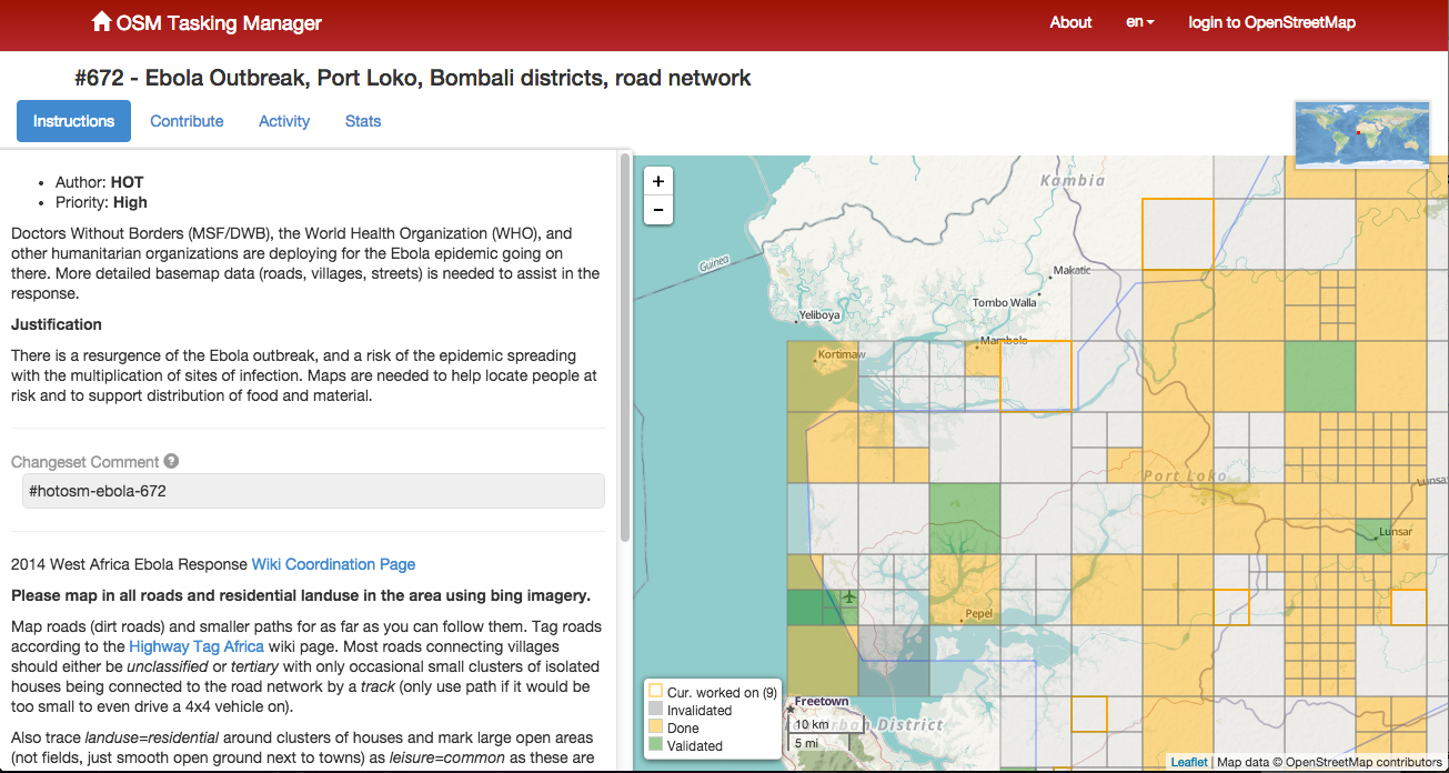
The National Geospatial-Intelligence Agency made available October 23 a public-facing website to assist U.S. and international relief efforts to combat the spread of the Ebola virus disease, providing unprecedented online access to its unclassified geospatial intelligence in support of lead federal agencies and partners.
NGA’s efforts add important value to the support offered by other organizations, including the All Partners Access Network, which provides community spaces and collaborative tools to the Department of Defense and mission partners to leverage information to effectively plan, train and respond to mission objectives.
“The dynamic site provided by NGA allows the agency to automatically federate its geospatial content, which then is used by organizations such as APAN for mission-related efforts,” said agency Director Robert Cardillo.
NGA’s role in the Ebola crisis has been in step with many other global events that have required the agency’s disaster support, including Hurricane Katrina in 2005, the Haiti earthquake in 2010, Hurricane Sandy in 2012 and Typhoon Haiyan in 2013. The
agency’s focus on unclassified support to the crisis allows its content to be available with no caveats or limits in distribution.
The large number of non-governmental organizations, or NGOs, involved in the relief effort requires NGA take a different approach to disseminating unclassified information so the people who need NGA’s information on the crisis, have it.
The dynamic site uses Esri’s ArcGIS Platform hosted in the cloud by Amazon Web Services, both publically available services. The site features various base maps that provide foundational context for users, who will then have the ability to visually overlay public NGA data, as well as ingest open-source data. NGA’s data can provide logistical information relevant to the situation on the ground affected by the Ebola crisis.
NGA’s first exposure of data includes geospatial layers relevant to the Ebola outbreak in Guinea, including cultural places and structures, and communication, electric power and ground transportation infrastructure. For example, Ebola cases by province and
locations of emergency treatment units will be visually accessible for users to ascertain the distance from a certain airfield to the closest emergency treatment unit.
Under Foundation GEOINT Content Management (FGCM) contracts, Harris will create high-quality data and products of the Pacific, North America, South America, and Africa regions of the world for use by the U.S. intelligence community and military. FGCM will contribute to and maintain a comprehensive, geospatially accurate map of the world that can be accessed quickly as intelligence, operational, and crisis needs arise.
Harris will use its One Feature One Time database, which automatically eliminates data redundancy and stores the most current representation of each geospatial feature. This capability ensures data currency and significantly reduces the time required for processing and delivery of products compared with traditional methods.
“Our unique solution provides improved accuracy, reduced production costs and significantly faster turn-around of geospatial products and content,” said Bill Gattle, vice president and general manager, National Programs, Harris Government Communications Systems. “This major win continues our legacy of providing high quality, responsive geospatial products to the intelligence and military communities.”
zLense, a specialist provider of virtual production platforms to the film, production, broadcast and gaming industries, is offering a depth-mapping camera that captures 3D data and scenery in real-time and adds a 3D layer to the footage. The camera is optimized for broadcasters and film productions.
The technology processes space information, making new and real three-dimensional compositing methods possible, enabling production teams to create 3D effects and use state-of-the-art CGI in live TV or pre-recorded transmissions, with no special studio set up.
With the zLense Virtual Production platform, directors can produce simulated and augmented reality worlds, generating and combining dynamic virtual reality (VR) and augmented (AR) effects in live studio or outside broadcast transmissions. The depth-sensing technology allows for a full 360-degree freedom of camera movement and gives presenters and anchormen greater liberty of performance. Directors can combine dolly, jib arm and handheld shots as presenters move within, interact with and control the virtual environment and, in the near future, using only natural gestures and motions.
“We’re poised to shake up the Virtual Studio world by putting affordable high-quality real-time CGI into the hands of broadcasters,” said Bruno Gyorgy, President of zLense. “This unique world-leading technology changes the face of TV broadcasting as we know it, giving producers and program directors access to CGI tools and techniques that transform the audience viewing experience.”
Doing away with the need for expensive match-moving work, the zLense platform dramatically speeds up the 3D compositing process, making it possible for directors to mix CGI and live action shots in real-time pre-visualization and take the production values of their studio and OB live transmissions to a new level. The solution is quick to install, requires just a single operator, and is operable in almost any studio lighting.
“With minimal expense and no special studio modifications, local and regional TV channels can use this technology to enhance their news and weather graphics programs — unleashing live augmented reality, interactive simulations and visualizations that make the delivery of infographics exciting, enticing and totally immersive for viewers,” he continued.
The zLense Virtual Production platform combines depth-sensing technology and image-processing in a standalone camera rig that captures the 3D scene and camera movement. The matte box sensor unit, which can be mounted on almost any camera rig, removes the need for external tracking devices or markers, while the platform’s built-in rendering engine cuts the cost and complexity of using visual effects in live and pre-recorded TV productions. The zLense Virtual Production platform can be used alongside other, pre-existing, rendering engines, VR systems and tracking technologies.
The VFX real-time capabilities enabled by the platform include:
Volumetric effects
Additional motion and depth blur
Shadows and reflections to create convincing state-of-the-art visual appearances
Dynamic relighting
Realistic 3D distortions
Creation of a fully interactive virtual environment with interactive physical particle simulation
Wide shot and in-depth compositions with full body figures
The Open Geospatial Consortium (OGC) has issued a Request for Quotation/Call for Participation (RFP/CFP)in the OGC Testbed 11 Interoperability Testbed.
Testbed 11 sponsors have documented interoperability requirements and objectives for this testbed activity. Organizations selected to participate in Testbed 11 will develop solutions based on the sponsors’ use cases, requirements and scenarios, which are described in detail in the CFP. Participants’ solutions will implement existing OGC standards as well as new prototype interface and encoding specifications introduced or developed in Testbed 11. Prototype specifications may ultimately become OGC standards, revisions to existing OGC standards, or best practices for using OGC standards.
Testbed 11 sponsors include:
European Organization for the Safety of Air Navigation (EUROCONTROL)
Land Information New Zealand (LINZ)
National Aeronautics and Space Administration (NASA)
National Geospatial-Intelligence Agency (NGA)
UAE Ministry of Interior Abu Dhabi Police GIS Center for Security (UAE ADP-GIS SC)
UK Defense Science and Technology Lab (UK-DSTL)
US Department of Homeland Security (DHS)
US Geological Survey (USGS)
The RFQ/CFP and information about Testbed 11 are available online. Responses are due by 5 p.m. EST on November 21, 2014.
Testbed 11 focuses on spatial communication requirements that emerge when a population is displaced due to coastal inundation. Testbed participants addressing requirements in this scenario will attempt to meet these goals:
Advance OGC Architecture with respect to REST and SOAP design patterns for synchronization of geodata across data stores, as well as storage and synchronization of geodata in GeoPackages;
Evaluate approaches to JSON and GeoJSON encodings as well as vector data and image streaming in the OGC standards framework;
Integration of high-resolution simulation models into geospatial infrastructures
Advance use of Linked Data and Semantic Enabling of OGC Web Services, with a special focus on Hydrographic Data;
Advance use of OGC Catalog Services;
Advance use of spatially enabled Social Media data;
Advance use of a common symbology that can be used to share common operational pictures in an international environment;
Advance compliance tests for the OGC Web Feature Service and Catalog 3.0 Service interface standards;
In Aviation, advance a Digital NOTAM validation service and enrichment service and advance use of Aviation Feature Schema (AFX). Also develop guidance on using geometrical constraints in the Semantics of Business Vocabulary and Rules (SBVR) (an Object Management Group standard).
Those testbed goals sort into these technology threads:
Cross-Community Interoperability (CCI) Thread
Urban-Climate Resilience (UCR) Thread
Geospatial Enhancements for NIEM (Geo4NIEM)
This cutting edge technology work has enormous potential for testbed stakeholders — both technology users and the technology providers — and for the world at large. The return on the shared investment in spatial standards is extraordinary, much like the return on the original shared investments in http and html. Technology providers who participate in the testbed gain market exposure, market intelligence, and a chance to quickly take advantage of the business opportunities that arise with the introduction of new standards and associated technical capabilities.
If you want to learn more about this opportunity, please contact Lew Leinenweber , Director Interoperability Programs ([email protected]). See http://www.opengeospatial.org/ogc/programs/ip for more information about the 15-year-old OGC Interoperability Program in which OGC testbeds, pilot projects and interoperability experiments are organized, planned and managed.
The OGC is an international geospatial standards consortium of more than 495 companies, government agencies, research organizations, and universities participating in a consensus process to develop publicly available standards. OGC standards support interoperable solutions that “geo-enable” the Web, wireless and location-based services, and mainstream IT.
Esri has launched a story map for the One Million Community Health Workers Campaign, which aims to expand and accelerate community health-worker programs in sub-Saharan African countries. With the use of the latest communications technology and diagnostic testing materials, these frontline workers link the rural poor to the broader healthcare system of doctors, nurses, hospitals and clinics.
The map was designed to be a constantly evolving tool, regularly updated with information submitted by organizations deploying community health workers across sub-Saharan Africa. The map is refreshed every month as new data becomes available. The date of the data refresh can be found in the legend.
With GeoLearn’s abilities, MSPS can provide more options to its members who seek continuing education opportunities. By accessing the online learning portal through the MSPS website, professional land surveyors and their staff can improve or refresh their knowledge base of land-surveying practices relevant to Missouri.
According to GeoLearn, the online interface is easy to use, affordable, and provides a tool to inventory all course work taken through GeoLearn for easily tracking continuing education credits earned. This is a modern way to get a quality service and course content that is specifically addressed to Missouri-licensed land surveyors. The coursework is available with no delay once a person is signed up for the presentation they select. There is also the convenience of being able to enter the portal and get continuing education credits anytime, at any place.
“We’re happy to partner with MSPS in providing online training,” said GeoLearn CEO Joe Paiva. “We’ve already collaborated with them, Seiler and Mo DOT in producing a free course for the public, on how to use the Missouri DOT Real Time (GPS) Network; many users, not just surveyors, have questions about the network, how they can access it and use it.” In addition, MSPS has launched two Missouri-specific courses on survey minimum standards, presented by J. Michael Flowers, PLS.
The Missouri Society of Professional Surveyors is the premier professional association in Missouri for those engaged in the practice of land surveying. Its purposes include representing the interests of, and to be the primary voice for, the surveying profession in the state; elevating the standards of practice for land surveying in the state for the benefit the public; supporting the general public and offices of public records by encouraging the delivery of superior land surveying services that upgrade land records; sponsoring legislation and educational programs beneficial to the public and land surveyors; and striving to improve the professional recognition of the profession by the public and other related professions.
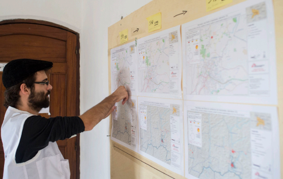
The American Red Cross Geographic Information System team is enlisting volunteers to help map areas in Africa hard hit by the ebola virus. The Red Cross is attempting to get ahead of the virus by creating detailed maps of rural towns and villages so officials can track the deadly virus as it spreads, according to ABC News. Volunteers have been drafted to study satellite imagery of homes, schools and villages.
Once the maps are detailed, they are sent to Red Cross partners, including Doctors Without Borders and the International Federation of the Red Cross and Red Crescent, which are working in the field to treat victims and stop the outbreak.
The maps are useful in a variety of ways. With better maps, epidemiologists can track where the disease is spreading, and find sick individuals in remote areas. In a specific example, the World Health Organization requested that GIS professionals look at cemeteries, a key location where infection can occur.
The volunteers have been able to fine-tune maps of remote villages which are used by relief workers trying to navigate rural roads, towns and neighborhoods. For instance, the original map for Guéckédou, Guinea, a town near the epicenter of the outbreak, showed just nine roads. After volunteers studied satellite photographs, they were able to add hundreds of roads and streams.
The project goes both ways, as people working in the remote areas send in GPS locations for villages that have never been mapped before. The maps can be vital to fight Ebola in rural areas where road signs, maps and GPS locations are scarce.
A GIS expert helps the Doctors without Borders epidemiological team respond to the ebola outbreak. Photo: American Red Cross Geographic Information System
The effort is similar to an effort by MSF-Switzerland (Doctors without Borders) in March 2014, which deployed a dedicated GIS officer to Guinea in response to the Ebola outbreak in the south of the country. During his eight-week his mission, the GIS officer produced 109 maps for this previously very poorly mapped area. The maps included basic orientation maps that showed roads, landmarks and villages but also specialized maps that visualized population density or the spread of the disease.
With the help of the newly created database and subsequently produced maps, the GIS officer was able to pinpoint the exact location of villages and identify villages that had the same name but were in different parts of the prefecture. Based on this information, MSF program staff were able to respond to the outbreak faster, in a more targeted way and with fewer resources.
Plus, the weekly mapping of confirmed and suspected Ebola cases helped translate the progression of the epidemic from technical data into an easy-to-grasp map. As a result, staff at all levels had a better understanding of the emergency.
Just like the American Red Cross is currently doing, the GIS unit crowdsourced certain mapping tasks, which resulted in a substantial number of overview maps created with the help of close to 250 online volunteers. The volunteers helped to map previously unmapped cities and roads within a few days, and at a granular level, mapping individual buildings. These overview maps then became the foundation of many maps that the GIS officer created for the outbreak response.
To learn more about that project, download a PDF report, “GIS Support for the MSF Ebola response in Guinea in 2014.”
For historical context, Esri’s ArcGIS is provides a story map that shows previous ebola outbreaks in Central Africa, 1976–2013, as well as the current outbreak. The interactive story map explores the first known contact with the disease in 1976 in the Democratic Republic of Congo and every outbreak since then, including the ongoing crises in Guinea, Liberia, Sierra Leone, and Nigeria. Users get basic statistics about each outbreak and browse reports from different agencies, all directly within the map.
Eric Gakstatter, contributing editor of GPS World and Geospatial Solutions, talks with Sarah Liu of Supergeo Technologies, Inc., about the company’s GIS solutions for worldwide users while at InterGeo, held October 7-9 in Berlin.
Leica Geosystems, Aibotix and Headwall Photonics are offering an integrated high-performance airborne sensor solution using a hyperspectral imager and the Aibot X6 unmanned aerial vehicle (UAV). The Nano-Hyperspec sensor is optimized for size, weight and power to enable aerial acquisition of all spectral and spatial data within the scene of interest. A UAV with integrated Headwall sensor has been successfully flown and was presented at InterGeo 2014, held last week in Berlin.
Precision agriculture, forestry, geological research, and environmental monitoring are application areas that can benefit from the airborne hyperspectral imaging solution, the companies said. Equipped with the hyperspectral imager, the Aibot X6 can, for example, take pictures of fields or vineyards to determine the chlorophyll content, plant health, and invasive species, and offer farmers information on the state of the plants and harvest. By means of UAV and hyperspectral imager, farmers can measure before harvest, where the grain is driest or should be mowed first. Or, they can determine where rain has washed away fertilizer and where they must re-fertilize.
For geological mapping, landfills and open mine sites can be overflown to quickly and efficiently track precious metals or minerals. Environmental monitoring and research to derive contamination of soil or water can be determined spectrally from the air quickly using the Aibotix UAV and Nano-Hyperspec sensor.
The Nano-Hyperspec sensor measures 76.2 x 76.2 x 119.4 millimeters and weighs less than 0.68 kg. The sensor is integrated with a high-speed data processor and high-capacity flash storage. It collects image data across 640 spatial bands and 270 spectral bands with a Visible-Near-Infrared (VNIR) range of 400-1000 nm. The field of view is exceptionally wide, meaning that flight swath efficiency is maximized to cover as much territory as possible while the UAV is aloft. Further, it delivers crisp image data not only directly underneath the flight path but off to the edges.
The integrated data storage is 480 GB, which will yield more than two hours at a frame-rate collection rate of about 100 fps, which is matched to the actual performance of the UAV itself. The direct-attached GPS with IMU yields the ability to generate ortho-rectified imagery data products.
The Nano-Hyperspec comes pre-loaded with an airborne version of its Hyperspec III application software that manages sensor operation, image acquisition, and sensor performance while aloft. Hyperspec III software is designed to work in a complementary fashion with the GPS/IMU as well as incoming LiDAR data to collect spectral data and generate a completely integrated hyperspectral data cube.
Airbus Defence and Space and Exelis are teaming up to provide users of ENVI image analysis software a limited-time voucher offer for new imagery as well as easy access to the Airbus Defence and Space imagery archive through an application programming interface (API) plug-in integrated within Exelis’ ENVI software. The partnership between Airbus Defence and Space and Exelis helps to expand the network that makes imagery easily accessible to GIS users, the companies said.
The voucher program will offer a specific amount of Airbus Defence and Space imagery free of charge with any new ENVI license purchase, starting October 1, 2014. ENVI combines advanced spectral image processing and geospatial analysis technology with a modern, user-friendly interface. ENVI users will be able to integrate the Airbus Defence and Space imagery they receive through this program seamlessly into the ENVI software for use in applications such as feature extraction, change detection analysis, target identification, and more.
The partnership has enabled Exelis and Airbus Defence and Space to develop and integrate an extension in ENVI software that directly connects to the Airbus Defence and Space imagery archive via an API. This allows ENVI users the opportunity to search and discover the Geo-Intelligence imagery archive directly within their ENVI environment. Users will have access to a full range of fresh optical and radar imagery including 1.5m SPOT 6 and SPOT 7 and 50cm Pléiades data.
“This agreement between Airbus Defence and Space and Exelis gives ENVI users easy access to a full range of fresh optical and radar imagery, providing them with more accurate results for their projects and helping them make better decisions,” said Bernhard Brenner, head of the Geo-Intelligence programme line of Airbus Defence and Space. “We are excited to see new opportunities developing with this growing partnership.”
“This integrated approach modernizes the way that people will discover data and access new imagery in conjunction with their existing imagery or GIS layers,” said Stuart Blundell, general manager at Exelis Visual Information Solutions. “By letting ENVI users easily identify and geo-locate thumbnail previews of available imagery within an area of interest without leaving the ENVI environment, our customers will save time and make better decisions in mission and project planning and execution.”
The voucher program will be available to new ENVI users as of October 1, and soon after all ENVI users will be able to search and discover the Airbus Defence and Space imagery archive.
Topcon Positioning Group will add the IP-S3 to its line of 3D mobile mapping systems by the end of this year. The fully integrated high-density digital imaging system is more compact, lightweight, and designed to scan at a rate up to five times faster than previous models.
Scanning at 700,000 points-per-second, the system is designed to offer data-rich results with its 30 MP panoramic imagery. Weighing 18 kg (39 lb.), the IP-S3 is engineered to offer simplified installation.
“The IP-S3 is a mobile mapping powerhouse,” said Charles Rihner, vice president of the Topcon GeoPositioning Group. “It bundles years of mobile mapping experience to glean a high-density and high-resolution camera in a unit that is much smaller than its predecessors. It is so lightweight that a single person could mount it on a vehicle without assistance from anyone else.”
The system pairs with Topcon Mobile Master Office software to perform all post-processing functions in a single application.
“Mobile Master Office software offers a complete workflow in a single package, turning raw sensor data collected by the IP-S3 system into rich and precise point clouds and images,” said Rihner.