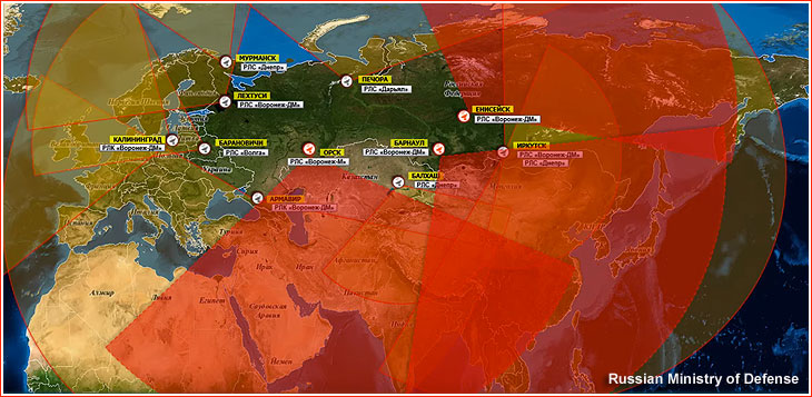
Russian satellites have caused GPS outages of as long as 10 seconds across Europe, according to a new research paper, authored in part by GNSS expert Todd Humphreys.
Humphreys is head of the Radionavigation Laboratory at the University of Texas at Austin. Separate research by Richard Bowden at Spanish company GMV supports the findings, according to The New York Times.
In at least three of 75 instances identified since 2019, the interference originated from as many as three Russian satellites. The other cases implicate the same Russian early-warning network; though data is insufficient to pinpoint the source, the same type of signal was identified.
Whether Russia knows of the interference — and its motives — is unknown, but the signals disrupt GPS, Galileo and BeiDou, and not Russia’s own GLONASS. The press office for the Russian Embassy in Washington, D.C. told The Times it had no comment.
The paper, “Chasing Lightning: Detecting, Characterizing, and Identifying a Powerful Space-Based GNSS Interference Source” by Zachary L. Clements, Argyris Kriezis and Todd E. Humphreys, can be accessed here.
The paper provides a comprehensive analysis of the GNSS interference phenomenon: wide-area transient interference from a space-based source causing up to 10-dB GNSS degradation across Europe since 2019 in the L1 band. The interference’s spatial, temporal and spectral properties are detailed. The researchers designed a framework to detect events using 1-Hz carrier-to-noise ratio observables from a network of 165 reference stations.
The three satellites implicated in the interference are part of Russia’s Edinaya Kosmicheskaya Sistema (EKS) constellation, which detects missile launches and nuclear explosions around the world. The first instance of this widespread jamming was recorded in October 2019, a month after the first EKS satellite was launched.
These cases are among the first known examples of GPS interference originating from space. Two historic cases of satellite interference were caused by technical glitches.
QinetiQ-led Team Elaris has been awarded a £6 million contract with the UK Ministry of Defence (MOD) to develop a deployable solution concept for enhanced long-range navigation (eLoran).
Work completed under the two-year Urgent Compass program will be used to inform future demonstration, production and deployment packages of work.
The UK and its allies rely heavily on position, navigation and timing (PNT) for effective military operations. PNT solutions traditionally use GNSS signals, but these can be jammed or spoofed by adversaries in battlefield environments. A jammed or spoofed satellite navigation signal, if undetected or uncorrected, can result in misdirected troop movements or incorrectly guided missile trajectories, leading to mission failure in the battlefield arena.
Militaries are increasingly looking for alternative, more resilient PNT solutions to enhance and complement traditional GNSS, such as eLoran which is a terrestrially based alternative and can operate when access to satellite PNT is denied. This program extends QinetiQ’s engagement with MOD on assured PNT solutions, which includes the Robust Global Navigation System (RGNS) program — another key component in UK MOD’s approach to resilient PNT.
Urgent Compass will explore eLoran based solutions that can be quickly deployed into contested locations worldwide.
Team Elaris is made up of QinetiQ, UrsaNav, Roke and GMV. Each organization brings technical knowledge and domain expertise in PNT technologies to the partnership, which is exploring both deployable and fixed eLoran solutions.
Celeste will test a complementary low-Earth-orbit layer for Galileo for more robust and accurate navigation.
At 10:38 CET on April 8, the Celeste IOD-1 satellite, developed by GMV and Alén Space under the European Space Agency’s (ESA) Celeste In-Orbit Demonstrator (IOD) program, successfully transmitted its navigation signal for the first time.
The reception of the signal from the Celeste IOD-1 satellite, confirmed by ESA teams at ESTEC, marks a key milestone for the program as it confirms the satellite’s successful commissioning in orbit. The signal was also received at GMV’s monitoring station in Lisbon.
The first two IOD satellites of the Celeste program — built by GMV and Thales Alenia Space, respectively — were launched March 28 at 10:14 CET from Rocket Lab’s Launch Complex 1 in Mahia, New Zealand. Separation from the launch vehicle took place one hour later, marking the start of the initial operations phase (LEOP) and commissioning, carried out by GMV for the IOD-1 satellite from the mission control center in Tres Cantos.
Next-generation LEO navigation
Celeste is ESA’s strategic program to demonstrate the benefits of an additional low Earth orbit (LEO) navigation layer that complements Galileo and EGNOS, with the goal of improving the accuracy, resilience and security of positioning, navigation and timing (PNT) services in Europe.
The in-orbit demonstrator (IOD) represents the program’s first phase and will validate key LEO-PNT technologies in flight ahead of potential future operational deployment.
The Celeste IOD phase is being carried out in parallel by two European consortia and will include a total of 11 satellites plus one in-orbit spare. As one of the prime contractors, GMV is responsible for the end-to-end mission for six of the demonstrator satellites, including system definition and design, the space and ground segments, the user segment, and operations.
Celeste programbeginnings
The Celeste program began with two demonstrator satellites, IOD-1 and IOD-2, aimed at securing registered frequency allocations and testing representative navigation signals through the end of the year. The mission will demonstrate precise autonomous orbit determination without relying on ground infrastructure, as well as stronger radionavigation signals in the L- and S-bands from low Earth orbit.
By demonstrating the advantages of integrating LEO capabilities into a multi-orbit architecture alongside Galileo (MEO), Celeste aims to improve resilience to interference and expand advanced navigation services. Operating at altitudes between 500 and 560 km, the Celeste demonstrators will assess how a complementary LEO layer can enhance Europe’s Galileo system in medium Earth orbit.
Eight additional, larger satellites are currently under development to extend the capabilities of the initial demonstrators. These will form part of the full fleet (eleven operational spacecraft and one spare) and will pave the way for subsequent launches starting in 2027.
GMV was selected in 2024 by the European Space Agency (ESA) to lead one of the parallel contracts for the development of Celeste. The first satellite in the constellation, a 12U CubeSat named Celeste IOD-1, was jointly developed by GMV and Alén Space.
In recent months, Celeste IOD-1 has undergone a complex assembly and integration process, as well as rigorous environmental and system testing. The results of these tests, carried out at GMV’s facilities, confirmed that the satellite was ready for launch, as well as for initial LEOP (Launch and Early Orbit Phase) operations and in-orbit experimentation activities.
GMV is leading the development of a secure two-way satellite time and frequency transfer system under the European Space Agency’s TOUCAN project.
The initiative safeguards critical infrastructure by reducing reliance on GNSS and enhancing national positioning, navigation and timing (PNT) capabilities. Funded by the UK Space Agency through its membership in ESA’s Navigation Innovation and Support Program (NAVISP), the project is an important part of the UK Government’s Framework for Greater PNT Resilience.
Through a competitive process, GMV was selected to enhance the UK’s national capabilities in delivering nationally assured, secure and continuous PNT services for critical infrastructure, defense and the broader economy.
TOUCAN, the two-way satellite time and frequency transfer capability demonstration (TWSTFT), will draw on GMV’s expertise in time transfer and system-level engineering, reinforcing the company’s role in supporting the government’s PNT resilience efforts.
“ TOUCAN represents a strategic milestone for GMV. It underscores our commitment to delivering cutting-edge, nationally assured, PNT solutions that are vital to the UK’s critical infrastructure and national security,” said Mark Dumville, general manager of GMV in the UK.
eLoran support
TOUCAN complements efforts to reestablish a UK eLoran system, which will serve as a terrestrial backup to satellite-based services. A critical goal is to ensure that this system operates independently of the more vulnerable GNSS.
The project’s primary objective is to establish an accurate, independently verifiable TWSTFT link between the eLoran transmitter and the National Physical Laboratory (NPL), the UK’s official timekeeping authority. The new link will address GNSS-dependence within eLoran, maintaining a time traceable to UTC (NPL).
In addition, the system will provide a TWSTFT connection to a facility that operates an R&D timescale, a secure reference that will one day be essential for synchronizing operations, maintaining communication integrity, and supporting mission-critical systems.
“Precise and secure timing is at the heart of so much we rely on every day, from banking and transport to energy and communications,” said Paul Bate, CEO of the UK Space Agency. “This investment in UK satellite timing through TOUCAN is about more than technology; it’s about protecting the everyday services people and businesses depend on. By working with GMV, the PNT Office and ESA’s NAVIS program, we’re helping to build a stronger, more resilient space ecosystem that safeguards our security and keeps the UK at the forefront of innovation.
GMV is delivering the design, integration and operational demonstration of the system, building on its proven track record in delivering secure national timing products and infrastructure. Project partner Viasat is supplying satellite bandwidth, as well as supporting GMV in analyzing innovative TWSTFT technology evolutions.
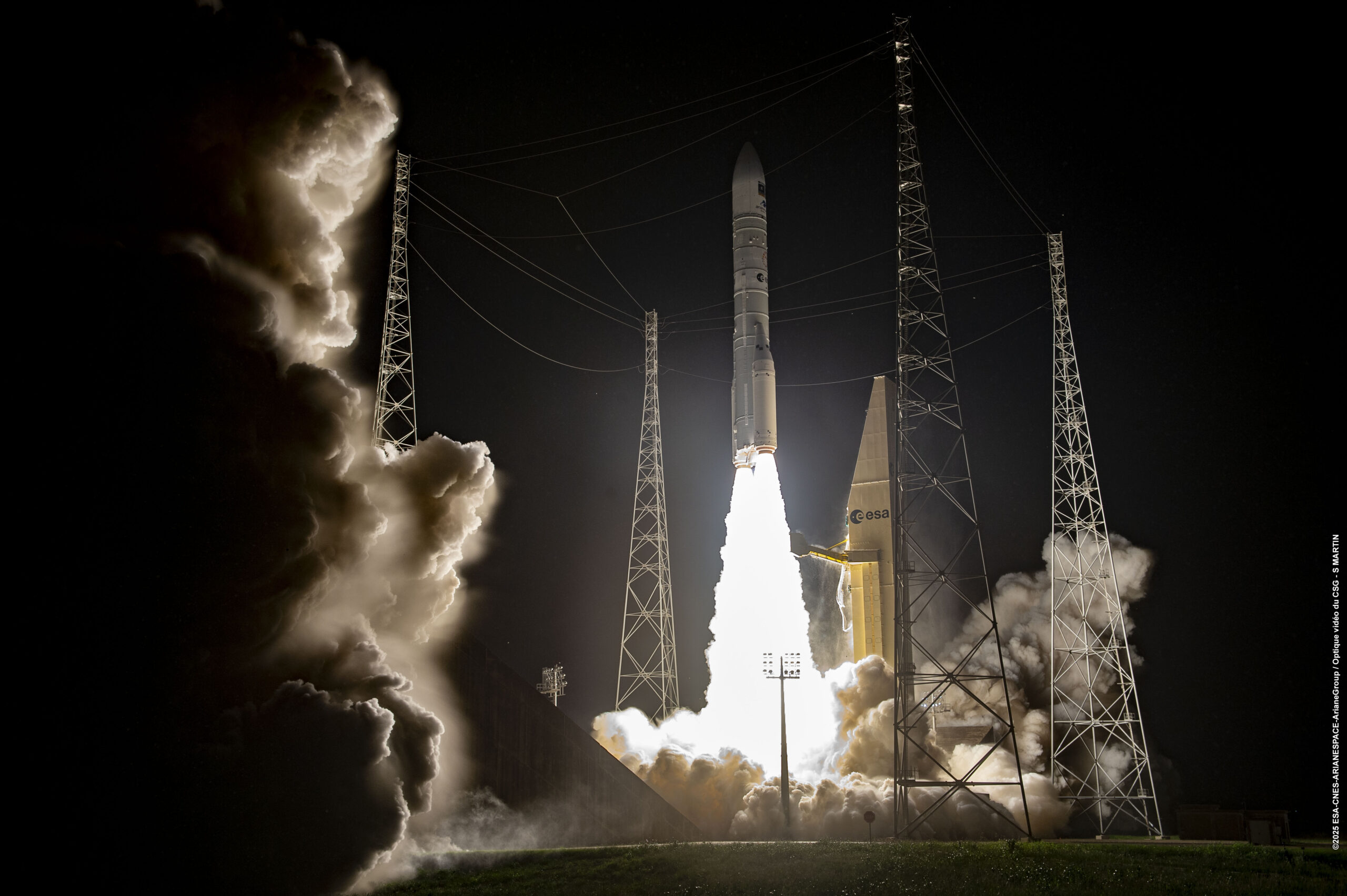
Europe has given fresh momentum to its Galileo navigation system following the successful Dec. 17 launch of two new satellites aboard an Ariane 6 rocket. The launch, the 14th of the program (L14), is one of the final three planned launches of first-generation (G1G) satellites. The two new satellites will strengthen the global positioning, navigation and timing services provided by the system.
The launch comes at a critical moment for the constellation, which needs to replace its oldest satellites, stated GMV, lead developer and operator of the Galileo ground control segment.
More than 4 billion users worldwide routinely rely on Galileo. This launch milestone ensures Europe’s ability to operate its own radionavigation system, which is essential for intelligent transportation, logistics, precision agriculture, defense, public safety, communications network operations, and energy generation and transmission.
From centers in Oberpfaffenhofen, Germany, and Fucino, Italy, GMV manages post-separation operations from the launch vehicle and ensures the correct insertion of the new satellites into the constellation. GMV also operates 24/7 to monitor the health and position of each satellite, plan and execute orbital maneuvers, ensure signal integrity, and manage critical system operations.
Coming soon: Second-Gen Galileo
The L15 and L16 missions will complete the first generation of the system before transitioning to the second-generation Galileo satellites (G2G) under development. These will introduce advanced capabilities, greater accuracy, and enhanced resilience against interference and cyber threats, further strengthening Galileo’s role as a strategic infrastructure for Europe.
The European Space Agency (ESA) has confirmed plans to launch the first two satellites in its low-Earth orbit (LEO) positioning navigation and timing (PNT) constellation in the second half of December 2025. The launch will use a Rocket Lab Electron Vehicle, marking Europe’s first venture into LEO-based satellite navigation.
The LEO-PNT in-orbit demonstrator mission, called Celeste, aims to test satellite navigation capabilities in LEO and evaluate its integration with existing medium-Earth orbit (MEO) systems.
Celeste features a constellation of ten satellites that will fly close to Earth to test innovative signals across various frequency bands. The first two Celeste satellites, built in parallel by GMV and Thales Alenia Space, are set to launch in the coming months.
The dedicated Electron rocket launch will place both satellites in orbit at 510 km altitude. The launch window extends for three months beginning in mid-December 2025, with operations conducted from Rocket Lab’s New Zealand facility.
ESA Director of Navigation, Javier Benedicto, said, “We are thrilled to see the LEO-PNT demonstration advancing so quickly, with less than two years between mission kick-off and launch. This launch ensures the first European LEO-PNT satellites are in space before spring 2026, crucial for bringing the frequencies into use in compliance with the International Telecommunications Union.”
Galileo’s “Daughter Mission”
The name Celeste pays homage to Maria Celeste, Galileo Galilei’s daughter, as the two shared a strong emotional and intellectual bond, with the daughter honoring her father’s astronomical interest. This symbolic connection links the pioneering work of the father of modern astronomy to contemporary navigation systems, with Celeste serving as a bridge between Galileo’s groundbreaking discoveries and today’s satellite-based positioning technology.
The demonstrator satellites for Galileo, launched in 2005 and 2008, were called GIOVE, after the Italian word for Jupiter. This name also paid tribute to Galileo’s achievements in discovering the planet’s four largest Moons which were used to determine longitude from anywhere on Earth.
System Advantages
The initial Pathfinder A satellites are CubeSats measuring 12U and 16U formats, comparable to suitcase size and weighing approximately 20 kg to 30 kg. These satellites will broadcast in L-band and S-band frequencies and operate for at least six months following orbital commissioning.
The larger, more complex Pathfinder B satellites will follow, incorporating additional payloads to test innovative signals across multiple frequency bands and demonstrate expanded services.
LEO-PNT satellites will supplement existing GNSS constellations by providing enhanced coverage in challenging environments. The system aims to improve navigation services in deep urban areas, under heavy foliage, in polar regions and potentially indoor locations where current MEO satellites face limitations.
The complete demonstrator constellation, expected to be operational by 2027, will assess how LEO navigation systems can integrate with existing GNSS infrastructure. The mission will also test interoperability with 5G and 6G communication standards.
Preparing for Launch
Satellite integration and testing of Pathfinder A hardware and software continues ahead of the December launch. ESA and industrial teams plan to complete testing during summer 2025, with qualification and acceptance reviews scheduled for autumn.
“Pathfinder A satellites have already paid off, even before launch,” said Roberto Prieto-Cerdeira, ESA’S LEO-PNT project manager. “The experience gathered during their development is helping to identify critical technologies, system design trade-offs, design choices and optimised approaches and processes, paving the way for future phases of LEO-PNT. Having them in orbit and validating their signals and algorithms is a major additional achievement.”
Future Plans
Following the demonstrator mission, ESA plans to propose an in-orbit preparatory phase at the agency’s November Ministerial Council meeting. This phase would focus on technology development and industrialization, potentially leading to an operational system integrated with EU GNSS infrastructure.
The Celeste demonstrator is part of FutureNAV, an ESA Navigation program designed to maintain Europe’s position at the forefront of satellite navigation technology.
The mission receives backing from 15 ESA member states: Austria, Belgium, Finland, France, Germany, Hungary, Italy, Norway, Poland, Portugal, Romania, Spain, Sweden, Switzerland and the United Kingdom. More than 50 entities from 14 countries participate in the two development consortia awarded contracts in 2024.
The rapid growth of satellite constellations in low-Earth orbit (LEO), the risk of orbital collisions is rising at an unprecedented rate. The increasing amount of space debris — ranging from active satellites to defunct assets and debris — poses serious challenges for operators striving to maintain the safety and sustainability of their missions. As daily data volumes grow and conjunction warnings become more frequent, the space community faces pressure to adopt more advanced and reliable collision avoidance solutions.
In response to these growing challenges, the European Space Agency (ESA) has awarded GMV a research and development contract under the ARTES Core Competitiveness program, aimed at improving collision avoidance services for large telecommunications constellations. The initiative will focus on developing advanced capabilities for FOCUSOC NXTGEN, a platform designed to deliver faster and more accurate collision risk assessments by using diverse data sources and enhanced response strategies.
As part of the project, a conjunction assessment center will be established in the United Kingdom to expand support for satellite operators both domestically and internationally. The new system architecture aims to handle higher volumes of data and provide scalable performance to match the needs of next-generation constellations, potentially exceeding 1,000 satellites per constellation.
FOCUSOC NXTGEN incorporates several features, including a dedicated database for trend analysis, a maneuver testing environment grounded in flight dynamics, API integration for efficient operations, and a redundant infrastructure to ensure continuous service availability. The system seeks to filter out false positives from daily orbital data, identify genuine threats more accurately, and deliver timely recommendations to operators for effective maneuver planning.
The service is set for launch in summer 2026 in coordination with industry partners. ESA officials note that enhancing orbital collision avoidance technologies will be crucial to maintaining safe and sustainable operations as satellite numbers continue to rise.
ESA’s ARTES Core Competitiveness program provides funding and expertise to strengthen the satellite communications sector across Europe and Canada. The program supports both technology development and efforts to bring innovative products and services to market.
Hi-Target, a Chinese high-precision positioning enterprise and manufacturer of high-end GNSS equipment, and GMV, a global technology group specializing in advanced navigation solutions, have established a strategic alliance to jointly develop integrated differential service solutions.
Through this partnership, Hi-Target and GMV support a wide range of automation-driven positioning applications — ADAS, robotics, UAVs, precision agriculture, smart infrastructure and intelligent mobility systems.
As industries progressively adopt automated technologies, precise and reliable positioning has become a foundational requirement across application domains. From today’s L2 and L2+ driver assistance systems (ADAS) in vehicles to autonomous UAV operations, robotic platforms, and the emerging needs of Level 3+ mobility solutions, the demand for scalable and high-accuracy positioning continues to grow.
The strategic alliance between the two companies leverages Hi-Target’s strengths in high-precision satellite navigation and user-grade GNSS systems, along with GMV’s extensive global expertise in precise navigation algorithms and satellite-based augmentation services. The result will be a high-availability, low-latency positioning service with global reach.
By combining their complementary technologies, including user-grade GNSS hardware, correction services, and augmentation infrastructure, Hi-Target and GMV will facilitate the adoption of high-precision positioning across various industries and geographic regions.
Their collaboration will support system integrators, OEMs, and solution providers in accelerating the development and deployment of automation in sectors with increasing levels of autonomy.
GMV has presented the latest results from its Enabling High-Performance PNT in the Lunar Environment (LUPIN) project, following a series of field tests conducted from April 27 to May 8 in La Oliva, on the Spanish island of Fuerteventura. The LUPIN initiative, developed in collaboration with the European Space Agency (ESA), aims to create a prototype navigation system that simulates the signals lunar surface rovers are expected to receive in the future. The goal is to establish a navigation system for the Moon similar to GPS on Earth, enabling more precise and reliable positioning for lunar missions.
As renewed interest in lunar exploration grows, the need for advanced technologies to support rovers, landers and potential human activities on the Moon has become a strategic priority for the space sector. ESA is pursuing this project under its Navigation Innovation and Support Program (NAVISP), seeking to test new positioning, navigation and timing (PNT) technologies. These technologies will integrate current planetary navigation approaches with distance measurement signals from the future Lunar Communication Navigation System (LCNS), a network of satellites orbiting the Moon that will provide GPS-like signals to the lunar surface. The system is being designed to serve specific lunar regions, including the south pole, the far side and permanently shadowed areas.
Navigation on the Moon currently faces significant challenges. Unlike Earth, the Moon lacks a satellite infrastructure like GPS, forcing spacecraft and rovers to rely on internal calculations and data relayed from Earth, which limits real-time location accuracy. The LUPIN prototype aims to address these limitations by reducing dependence on complex onboard algorithms and optimizing the performance of lunar exploration vehicles. Over the next decade, this technology is expected to transform how astronauts and vehicles operate on the lunar surface, enabling faster and more efficient route planning and reducing the computational burden required for navigation. This advancement means rover speeds will be limited only by lunar surface conditions, not technical constraints, potentially ushering in a new era of automated lunar exploration.
During the recent test campaign in Fuerteventura, the LUPIN system’s real-time navigation capabilities were successfully verified and validated. The tests simulated the LCNS positioning signals that future lunar rovers will use to determine their exact location. Steven Kay, GMV’s manager for the LUPIN project, explained the field tests performed and the corresponding details.
“We were able to successfully compile data over the course of 7 km of travel, and at various speeds, from the conventional 0.2 m per second, up to much faster speeds of 1.0 meters per second, which are the speeds of the future. In addition, we were able to simulate a whole range of lunar conditions and types of environments. This included tests performed at night, using a combination of simulated sunlight to emulate the illumination conditions found on the Moon, as well as tests performed in total darkness, using only the rover’s onboard lighting system to navigate,” Kay said.
The LUPIN project is part of broader efforts by ESA and its partners to develop lunar communication and navigation services, which are seen as essential for future scientific, commercial and human activities on the Moon
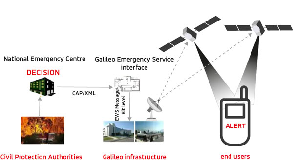
The European Union Agency for the Space Programme (EUSPA) has awarded GMV a framework contract to deliver new Galileo functionalities under the EmeRgency Alerting System (ERAS). This four-year contract, valued at approximately $6 million, will enable significant advancements in Europe’s disaster response capabilities. The GMV-led consortium includes Ineco, ALTEN Spain and Kineton as subcontractors.
ERAS will primarily allow Member States’ National Civil Protection Authorities to broadcast emergency warning messages directly to populations in at-risk or affected areas. These alerts will be transmitted via Galileo satellites to smartphones and other Galileo-enabled devices. According to EUSPA, the messages will contain crucial information about the hazard, including its type, severity, affected area, expected onset and duration, as well as guidance for appropriate responses.
The Galileo Emergency Warning Satellite Service (EWSS) and ERAS seek to enhance Galileo by offering resilience and complementarity to existing public warning systems, independence from terrestrial and mobile networks, rapid communication with global reach and particular benefits for remote areas with limited mobile coverage.
The system is designed to provide a robust and versatile solution for emergency communications, ensuring that critical alerts reach populations even in challenging scenarios. ERAS is expected to be fully operational in the first half of 2026.
The implementation of ERAS comes at a critical time, as highlighted by the State of the Climate in Europe (ESOTC) report for 2024. Europe has experienced numerous extreme weather events in recent years, including heat waves, forest fires, floods and droughts. The continent is warming at approximately twice the global average rate, emphasizing the urgent need for effective warning systems and robust climate policies, GMV shared.
The joint use of Galileo ERAS and the Copernicus Emergency Management Service seeks to enhance the European Union’s and its Member States’ disaster management capabilities. This integration will provide a comprehensive approach to alerting populations about risks such as the recent disasters in Valencia, Spain and other parts of Europe.
The European Union Agency for the Space Programme (EUSPA) has awarded GMV a six-year framework contract to upgrade the European GNSS Service Centre (E-GSC) infrastructure. The contract is valued at €35 million ($39 million).
The E-GSC is critical to the European Union satellite navigation program’s infrastructure. Its primary mission is to provide a unified interface for users of the Galileo and EGNOS systems, offer supporting services, and contribute to delivering new Galileo services. The E-GSC’s various functions include distributing data from the European Union navigation satellite services to the user community and supporting the growth of the global Galileo applications market.
Originally designed to be part of the European GNSS infrastructure and to provide a unified interface between the Galileo system and its users, the E-GSC has expanded its role over the years to become a key component in delivering services enabled by the European Union Space Programme.
The new framework contract aims to advance the E-GSC’s capabilities, enabling it to take on increased responsibilities. This includes creating new services for users, enhancing their experience, integrating service delivery aspects of Galileo and EGNOS, and supporting the development of additional services.
GMV is leading a consortium that features Indra as the main industrial partner, along with prominent companies such as Spaceopal, ESSP, Alten, the Universitat Politècnica de Catalunya (UPC) and the Universidad Autónoma de Barcelona (UAB).
Under the supervision of EUSPA as Contracting Authority, GMV will oversee project management and IT infrastructure development through all stages, including definition, implementation, validation and integration into the Galileo ground segment. GMV will also develop the software components necessary for delivering new data and signal authentication services for Galileo satellites.
Photo: Space Surveillance Operations Center (COVE)
The Spanish Ministry of Defense has awarded a $2.9 million contract to GMV, for the development, deployment support and maintenance of the Space Situational Awareness and Control System (CCSE). The system will be used at the Spanish military Space Surveillance Operations Center (COVE).
Under the contract, GMV will conduct orbit calculation and propagation, build-up and maintenance of a space object catalog (both open and classified), prediction of atmospheric reentry, calculation of overflight events, planning of observation and sensor calibration campaigns, calculation of GNSS signal degradation and integration and processing of space weather data.
This system is expected to go into service at the end of 2024. To comply with this timeline, it will be based on GMV’s Ecosstm system, which is being used in other operational environments such as the German Armed Forces’ Space Domain Awareness Center (Weltraumlagezentrum), the civilian space surveillance systems of various other countries such as Greece and GMV’s commercial space surveillance center known as Focusoc.
The COVE, which is operated by the Ministry of Defense (MINISDEF) through its Space Command (MESPA) of the Spanish Air and Space Force (EA), was created in November 2019. The center reached its initial operational capability (IOC) in 2021.
GMV has been supporting the center and assisting its participation in the Global Sentinel exercises organized by the U.S. Space Command. As part of its support, GMV has supplied its operational orbit determination tool, Sstod, for processing data from the Spanish space surveillance radar located at the Morón Air Base, near Seville, Spain.