The European Organization for the Safety of Air Navigation (EuroControl) has awarded GMV a contract for the evolution of AUGUR, a free service for pilots, airspace users and air navigation service providers.
AUGUR is a web-based service that makes it possible to predict the availability of the GPS and receiver autonomous integrity monitoring (RAIM) navigation solution for a wide range of air operations. The RAIM processing algorithm, which is standardized and incorporated into most aeronautical GPS receivers, allows operators to check the integrity of GPS satellite signals by exploiting the redundancy of measurements offered by the current constellation.
Although only four satellites in view are needed to calculate the position and time of the aircraft, the current GPS constellation has 31 active satellites, meaning that the receivers are getting signals from more than four satellites much of the time. The RAIM technique takes advantage of these additional measurements to check the integrity of the satellites and ensure the position obtained is correct within the alarm limits established for each operation.
Within the framework of the new project, GMV will lead all phases related to the development of the new AUGUR services, including the definition of requirements, design, implementation, verification, validation and software deployment. Throughout the process of designing, developing and validating the new version, GMV will also continue to provide the current services, ensuring that they are not interrupted. The new version will be available in May 2025.
The improvements made to the AUGUR include RAIM GPS availability displayed on a map and the integration of the planned Navigation Integrity Category (NIC), which measures the quality of the aircraft navigation position transmitted via automatic dependent surveillance–broadcast (ADS-B). It also issues space weather warnings such as solar flares, geomagnetic storms and coronal mass ejections (CME) and has options to import or export geographic data in industry-standard formats.
GMV and Astroscale UK are collaborating on a new project under the European Space Agency (ESA) collision risk and automated mitigation (CREAM) program. The project aims to transform satellite collision avoidance by using Galileo Signal-in-Space (SiS) capabilities.
As low-Earth orbits (LEO) become increasingly congested, satellite operators face difficulties efficiently carrying out collision avoidance maneuvers. In response, the ESA launched the project to explore alternative paths for late collision avoidance maneuvers. The collaboration uses the Galileo Return Link Service to improve the way satellites respond to collision risks.
Traditionally, communication with satellites for collision avoidance maneuvers has been constrained by the limited availability of ground station access. This limitation forces satellite operators to delay crucial avoidance maneuvers while relying on the final passes of ground stations.
GMV’s solution offers an alternative pathway for late maneuver commanding, designed to reduce the wait time for initiating collision avoidance. The initiative proposes a continuous and reliable communication path by using the Galileo, SiS and its Return Link Service. This approach allows for the seamless relay of collision avoidance maneuver decisions to satellites equipped with onboard Galileo-compatible GNSS receivers.
The Galileo system in this role also opens the door to potential synergy with other space situational awareness (SSA) services, such as the European Space Surveillance and Tracking (EU SST). According to GMV, this strategic collaboration could potentially set the foundation for a globally available collision avoidance service.
GMV has been selected by BMW Group to supply its safe and precise positioning technology, GMV GSharp, for the next generation of BMW Group’s autonomous vehicles.
GSharp is equipped with an onboard positioning engine (PE) software and a GNSS corrections service, allowing vehicles to collect augmentation data and safety-related information for computing an accurate and reliable user position.
Both the correction service and positioning engine are developed following the ISO 26262 and ISO 21448 standards to ensure compliance with safety requirements. The solution also complies with the concept of security-from-design as per ISO 21434, including the necessary counter-measures in the SW and system and in the GNSS related attack detection or anti-spoofing and anti-jamming schemes.
The most demanding automotive project management practices and industry standards for software engineering (A-SPICE CL3) have been applied during its development.
In addition to the software side, GMV’s solution relies on a secure and redundant physical infrastructure. GMV owns and operates a worldwide GNSS station network, which provides the GNSS raw data needed to generate the corrections. These corrections are computed within two physically independent data centers, providing GMV’s solution the required availability levels for automated driving applications.
Contract ceremony in Madrid, Spain, on June 22. (Image: GMV)
GMV has been awarded a major contract by the European Space Agency (ESA) to develop the ground control segment for the in-orbit validation (IOV) system of the Galileo Second Generation (G2G). The primary objectives of G2G are to introduce new services and technologies; improve existing services and technology; increase the accuracy and robustness of the system; strengthen security; and reduce the system’s maintenance costs.
The ground segment will be responsible for controlling the two new second-generation satellite platforms, which are currently in the design and production phase. A total of 12 satellites are expected to be launched over the next three years. The new ground control system is scheduled to come into operation in 2
025, coinciding with the launch of the first satellite of this second generation.
The new contract signed between GMV and ESA is worth over €200 million. This includes the contracting of core G2G activities, for a value of around €155 million. These activities will be carried out over a period of 42 months, from mid-2023 until the end of 2026, with options for extension until 2028.
Galileo currently serves more than four billion users worldwide, delivering global positioning, navigation, and clock synchronization services with a positioning accuracy of up to 20 cm.
U-blox has signed an agreement with GMV to combine GNSS receiver hardware from u-blox with GMV’s safe correction service and sensor fusion and positioning engine. This solution is suitable for automotive applications because it provides a holistic safety approach that maximizes performance and minimizes timetomarket costs.
Starting in April 2023, u-blox will directly commercialize the solution. This includes integration services and certification support provided jointly by u-blox and GMV for applications such as ADAS Level 2+ and vehicle autonomy.
The collaboration was forged at the recent Mobile World Congress (MWC), Barcelona 2023. The two companies will work hand in hand to integrate their technologies and provide a solution for the needs of future automotive application
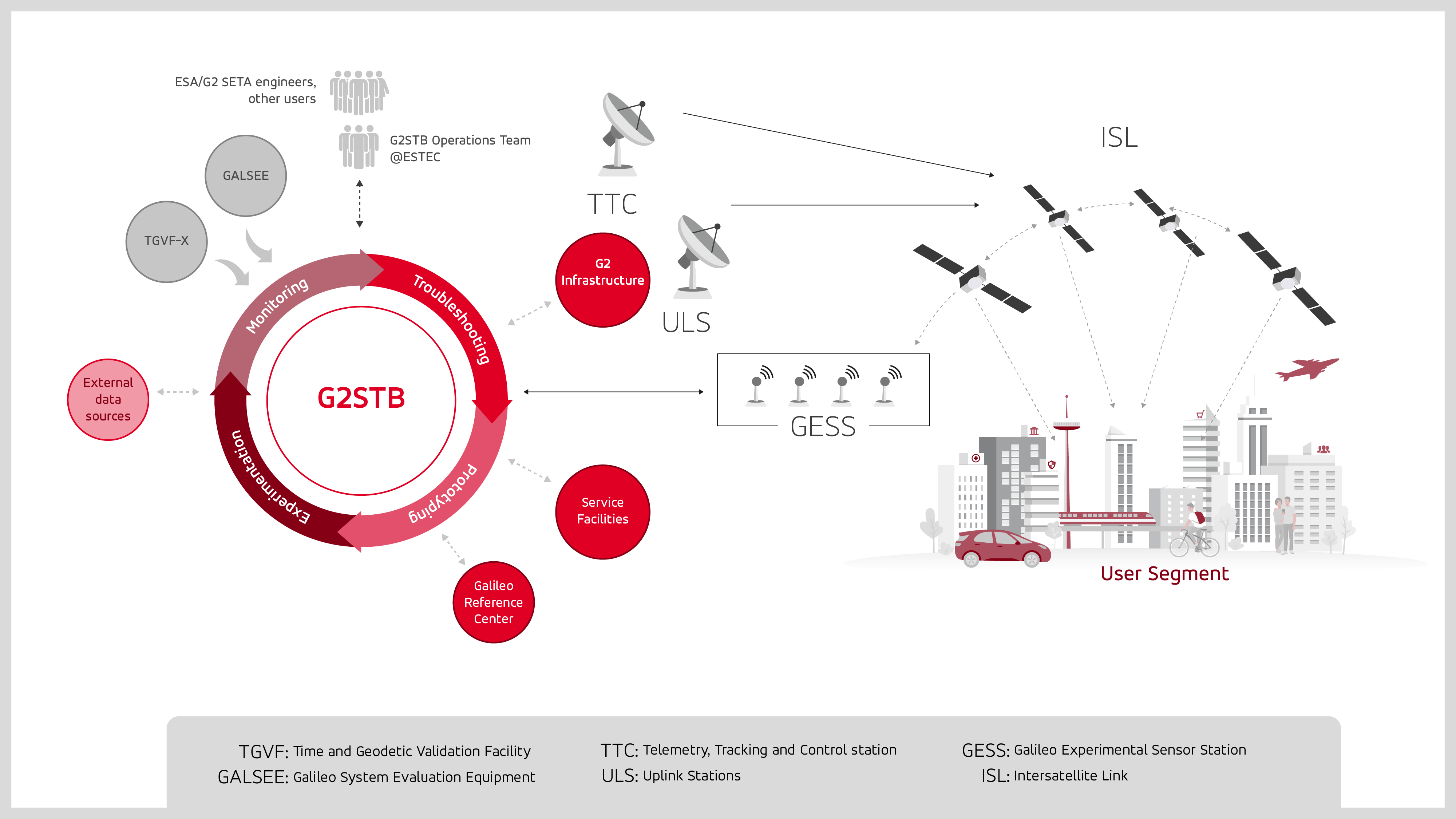
GMV has been selected by the European Space Agency (ESA) and the European Union Agency for the Space Programme (EUSPA) to develop the Galileo second-generation system test bed (G2STB). The G2STB will provide ESA with a key system verification and validation facility in support of its role as Galileo system development prime, enabling a wide range of Galileo system monitoring, troubleshooting, prototyping and experimentation activities.
GMV will deliver four G2STB versions over five years. Among these modules, the G2 high accuracy service (HAS) data generator and monitor aims to improve the Galileo HAS that was declared operational in January.
Other early capabilities of the G2STB include an upgraded orbit determination and time synchronization facility — capable of processing inter-satellite link data, a time service monitoring module, an integrity support message generator, a signal authentication service, an authentication validation module, an emergency warning service module, an ISL simulator and a G2G message composer.
The G2STB project aims for a smooth transition from the Galileo first-generation to the second-generation, building onto the G1G legacy system tools. The G2STB is one of the key infrastructure elements that ESA is developing for the correct functioning of the Galileo second-generation satellites.
The G2STB will eventually replace and upgrade the capabilities of the two first-generation facilities, the Galileo system evaluation equipment and the time and geodetic validation facility (TGVF-X). The latter, developed and operated by GMV over the last decade, has played a key role in monitoring the Galileo signals and system validation activities during the Galileo exploitation phase. The TGVF-X is also contributing to the early validation of new capabilities and elements being rolled out in recent and upcoming Galileo System updates.
In parallel to the development phase, the G2STB will help upgrade the network of Galileo experimental sensor stations to process new signals and capabilities to ensure the availability of a G2-capable, worldwide, multi-constellation network of receivers and bit-grabbers — independent from the operational Galileo sensor stations.
GMV is using high-resolution optical imagery as a part of emergency management efforts, to map the population and infrastructure of several cities in Turkiye after the 7.8 magnitude earthquake. The imagery of the aftermath is thanks to Europe’s Copernicus program, which keeps satellites and Earth observation services operational to support management and decision-making in different areas, particularly in the field of emergency management.
The satellite images show the challenge faced by rescue teams and reveal the massive amounts of destruction caused in cities across Turkiye and northern Syria. (Image: GMV)
GMV is one of the suppliers of Copernicus program infrastructure. GMV monitors the database architecture and ensures its integrity, analyzes the data required by the service chains, and identifies the most suitable technologies to keep the entire program operational.
GMV is working with the EU Civil Protection Mechanism’s Emergency Response Coordination Center to keep them updated on the ongoing emergency situation.
For more on the emergency satellite mapping, visit the Copernicus website.
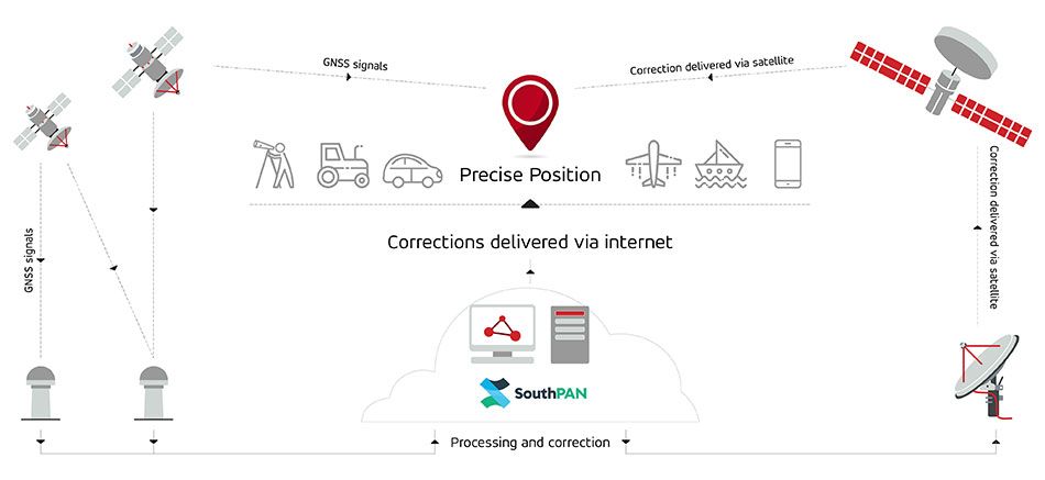
Multinational technology firm GMV has signed an agreement with Lockheed Martin Corporation to develop the processing and control centers for the Southern Positioning Augmentation Network system (SouthPAN). Lockheed is contracted to establish SouthPAN.
The project is a joint initiative of the Australian and New Zealand governments to provide a satellite-based augmentation system (SBAS) for navigation and precise point positioning (PPP) services. GMV will also be responsible for monitoring both of these services in the region and for ensuring compliance with the committed performance levels.
SBAS and PPP systems have applications in industries as diverse as agriculture and road, air, maritime and rail transportation, as well as in the field of geomatics. SouthPAN is expected to accelerate development of applications in these areas.
SouthPAN is also the first system with these characteristics available in the Southern Hemisphere. With this new program, Australia and New Zealand will be contributing to improved global coverage and interoperability for services of this type, joining the list of countries and regions that already have their own SBAS system: the United States (WAAS), Europe (EGNOS), India (GAGAN) and Japan (MSAS).
On Sept. 26, two weeks after the agreement was signed, the first services were provided by activating transmission of the system’s first signals. This was a significant milestone, because SouthPAN is the first project where an industry consortium provides an SBAS as a service, rather than as a turnkey system.
Image: SouthPAN
GMV’s role
GMV will be responsible for developing two key subsystems for SouthPAN: the Corrections Processing Facility and the Ground Control Center. The company will also be responsible for monitoring the system and ensuring it complies with the committed performance levels.
GMV also will provide support for the system’s operation and maintenance.
Corrections Processing Facility. The facility generates correction messages for signals transmitted by GPS and Galileo, improving precision for users by improving accuracy to as little as 10 centimeters.
The facility also detects malfunctions in the satellites and generates warnings for users. This will allow use of SouthPAN by civilian aircraft as a navigation system during various flight operations, including precision approaches to runways for landing.
Safety-of-life services such as these will be available in 2028.
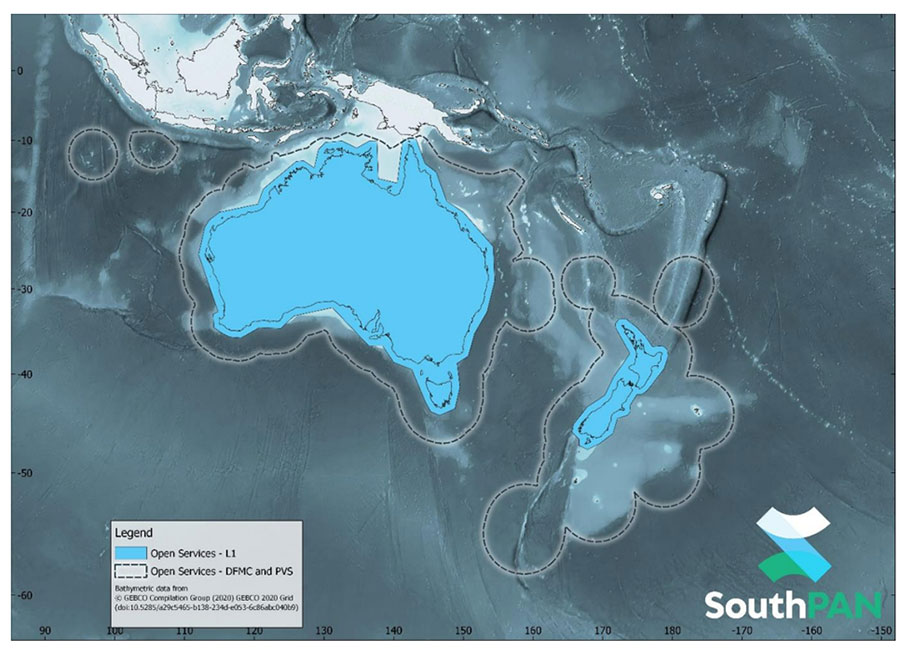
SouthPAN early Open Services coverage. OS-L1 covers mainland Australia and New Zealand. OS-DFMC and OS-PVS cover Exclusive Economic Zones in both countries. (Image: Geosciences Australia)
Ground Control Center. The control center remains in operation 24 hours a day seven days a week, and will perform all the functions needed to monitor and control the system. It will also provide information to users about the system’s operation and availability of services.
In Australia, SouthPAN development, entry into service and operation are being supervised by Geoscience Australia in collaboration with Toitū Te Whenua Land Information New Zealand.
In 2020, the two agencies signed the Australia New Zealand Science, Research and Innovation Cooperation Agreement (ANZSRICA). Over the next 20 years, the Australian government will be contributing 1.4 billion Australian dollars to the SouthPAN project.
Trials in Australia are proving 5G LPP can support new positioning services. (Photo: Dan Woodrow, FrontierSI)
Several companies are joining to demonstrate 5G LTE Positioning Protocol (LPP) capabilities in field trials. The trials are part of the 5G Positioning Testbed funded under the Australian 5G Innovation Initiative.
Technology partners include GMV, FrontierSI, Ericsson and Optus, who are joining with industry demonstration partners Kondinin Group, Platfarm (a precision agriculture company) and Position Partners.
The results achieved by the project are considered a key step forward for the use of 5G technology for high-accuracy positioning. The testbed demonstrated each of the high accuracy GNSS-based LPP working modes, including Observation Space Representation (OSR), State Space Representation (SSR), and SSR with atmospheric corrections, integrated directly with user equipment supplied by demonstration partners to examine a variety of real-world applications. The field trials demonstrated that the solution can reach centimeter-level accuracy with fast convergence times using a commercial off-the-shelf receiver and antenna hardware.
GNSS precise positioning is the most common technology for calculating an absolute positioning solution at the user level. For uses requiring centimeter-level accuracy, it is often required to provide GNSS corrections to reduce errors.
Distribution of GNSS corrections is based on either the broadcast of precise point positioning (PPP) corrections through GEO satellites over the L-band, or the point-to-point transmission of real-time kinematic (RTK) corrections using NTRIP through the internet.
Both options have their drawbacks: GEO satellite broadcast requires complex ground infrastructure and can be expensive to maintain, while NTRIP distribution has poor scalability due to the point-to-point connections required for every user.
3GPP (3rd Generation Partnership Project) — the standards organization focusing on 5G LPP — recently introduced the support of OSR corrections for RTK users in Release 15, and the support of SSR plus atmospheric corrections for PPP/PPP-RTK users in Release 16.
Support for these two approaches to high-accuracy GNSS positioning have increased interest in 5G LPP as a potential alternative to existing correction services. Service providers and positioning consumers can now consider the use of 5G LPP as a supporting technology in the provision of new positioning services directly through mobile networks.
The 5G Positioning Testbed has achieved end-to-end demonstrations of high-accuracy positioning solutions using GMV’s Corrections Service and Positioning Engine, delivered through the Optus 5G network using Ericsson network technology, to user equipment designed and operated by FrontierSI.
Field trials conducted in Australia involved real-world scenarios across three areas: precision agriculture, drone operation and augmented reality.
SouthPAN early Open Services coverage. (Image: Geosciences Australia)
The government of Australia has awarded Lockheed Martin a $1.18 billion contract to establish the Southern Positioning Augmentation Network (SouthPAN) to enhance precision.
The system is expected to be fully operational by 2028, and will be provided as a service for 19 years with an option to extend.
The program will use a unique, Lockheed Martin-developed, second-generation satellite-based augmentation system (SBAS) broadcasting on two frequencies to augment signals from two GPS and Galileo.
The SouthPAN initiative
The SouthPAN initiative will deliver a signal augmenting GPS and Galileo over the Australasia region, improving accuracy from 5-10 meters to within as little as 10 centimeters.
The greater positioning accuracy and integrity of the SouthPAN signal has applications across a range of users, including civil aviation, vehicle guidance, precision agriculture for efficiencies in crop management, tracking maritime shipments, and enabling navigation for drones and other unmanned vehicles.
Lockheed Martin Australia will work with the SouthPAN project team to establish a network of GNSS reference stations and satellite uplink facilities that will enable communications and transmissions with the SouthPAN space infrastructure.
SouthPAN is a partnership between Geoscience Australia and Toitū Te Whenua Land Information New Zealand (LINZ) under the Australia New Zealand Science, Research and Innovation Cooperation Agreement.
2017 testbed
Lockheed Martin tested a second-generation SBAS testbed in partnership with Geoscience Australia in 2017.
Lockheed Martin’s second-generation SBAS technology receives and monitors basic signals data from multiple GNSS through widely distributed reference stations. This data is collected by a SBAS testbed master station, which computes corrections and integrity bounds for each GNSS satellite signal, and generates augmentation messages.
The new messages are sent to an SBAS payload hosted aboard an Inmarsat geostationary Earth orbit satellite via an uplink antenna in Uralla, New South Wales. The Inmarsat satellite rebroadcasts the augmentation messages containing corrections and integrity data to the end users’ GNSS receivers. The whole process takes less than six seconds.
Lockheed Martin provided the systems integration expertise in addition to the Uralla radio frequency uplink; GMV-Spain provided its “magicGNSS” processors; Inmarsat provided the navigation payload hosted on the 4F1 geostationary satellite. The Australia and New Zealand Cooperative Research Centre for Spatial Information coordinated the demonstrator SBAS test-bed SBAS test-bed projects.
The SouthPAN contract will expand Lockheed Martin’s investments toward sustainable business growth in Australia. Currently, Lockheed Martin programs support 4,000 Australian jobs in advanced manufacturing and technology industries. The contract will grow that footprint with additional jobs in at least four states.
News from the European Space Agency (ESA). Europe’s first generation Galileo constellation is already the world’s most precise satellite navigation system — delivering meter-scale positioning to more than 3.5 billion users worldwide. The Galileo Second Generation will enable even better performance and an expanded range of services.
Essential elements of the G2 system are being evaluated in ESA laboratories, including key algorithms to synchronize satellite timing and determine orbits, as well as test versions of a GNSS receiver and emergency beacon.
Two independent families of satellites, totaling 12 G2 satellites, are being procured by Thales Alenia Space in Italy and Airbus Defence & Space in Germany. With their first launches due in the middle of this decade, G2 satellites will be much larger than existing Galileo satellites, and they represent a major technical step forward.
Backwards-compatible with the current constellation, the G2 satellites will incorporate numerous technology upgrades, developed through EU and ESA research and development programs. They will employ electric propulsion for the first time and host an enhanced navigation antenna. Their fully digital payloads are being designed to be easily reconfigured in orbit, enabling them to actively respond to the evolving needs of users with novel signals and services.
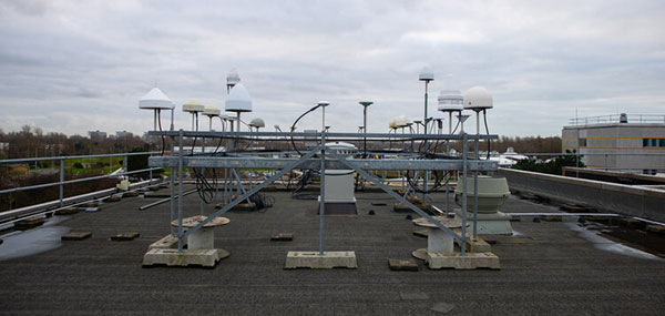
The GNSS antenna farm on the ESTEC roof for live signal reception. (Photo: ESA)
Algorithms at the heart of G2
At the heart of satellite navigation is the ability of the satellites to determine where they are in space and the precise time down to a few billionths of a second as they transmit their navigation signals. The greater the precision of these factors, the greater the accuracy of the positioning for users, because Galileo receivers take the time between the signals being transmitted and received and turn it into a measurement of distance. Signals from four or more satellites are used to pinpoint the receiver’s location.
The Advanced Orbit Determination and Time Synchronisation (ODTS) Algorithms Test Platform evaluates the advanced software that will perform these calculations for G2. Developed by Thales Alenia Space through an EU Horizon 2020 project coordinated by ESA, the platform is now installed and running in ESA’s Navigation Laboratory. The laboratory is based at ESA’s technical heart, the ESTEC establishment in the Netherlands, where it is helping simulate how the G2 satellites will operate in practice.
“This platform represents a dynamic, highly-performing environment for algorithm experimentation in both real-time and post-processing modes, using either real or simulated data,” said Francisco González, the project’s technical officer. “It contains the algorithmic core of Navigation for Earth Orbit Determination and Identification Segment, NEODIS, which is the suite of algorithms developed by Thales Alenia Space for precise orbit determination of the satellite constellation. These algorithms allow the real-time estimation of orbits and clocks, as well as the generation of Galileo navigation messages, with an estimated accuracy in the tens of centimeters.”
“Important evolutions aimed at improving the estimation of clocks and orbits are being incorporated,” said Gustavo Lopez-Risueno, head of ESA’s Galileo G2 System Engineering Unit. These improvements include:
integration of composite clock algorithms for a stable and robust reference timescale
the dynamic modeling of satellite and station clocks based on their known behavior
the processing of auxiliary measurements such as laser range measurements, in which lasers are reflected off of satellites to measure their orbital position, delivering a ranging accuracy down to under a centimeter —significantly better than the half-meter or so available from radio ranging
intersatellite links.
The first G2 receiver prototype “breadboard” is now running in ESTEC’s Navigation Lab. (Photo: ESA)
First G2 receiver up and running
Another outcome of ESA-led H2020 research is also up and running in the lab: the first G2 receiver prototype “breadboard,” developed by GMV.
“Its development has been key to supporting the fine-tuning and assessment of some signal design options we are considering,” said Jose A. Garcia-Molina, who leads the G2 signal-in-space design at ESA. “Representative mass-market receiver processing architectures and techniques have been considered to assess the final benefits a user would receive.”
“This first G2 receiver breadboard allows us to better understand the performance G2 can achieve in different user conditions, such as the urban environments in which many Galileo users are based today,” said Miguel Manteiga Bautista, who leads ESA’s G2 Programme.
Meanwhile, two parallel activities have been started for development of the G2 test user receiver. The receiver will be taken outside the lab for various test activities ahead of the first G2 launches, and then again for in-orbit testing and validation.
Arctic Mass Rescue Operation in 2021 tested the rescue of 200 cruise-ship passengers using Galileo SAR. (Photo: EUSPA)
Search-and-rescue system also being updated
Nearby, in ESTEC’s Telecommunications Lab, is the G2 search and rescue test beacon simulator, now operational following site acceptance testing.
Like their first-generation predecessors, the G2 satellites will pick up emergency signals from beacons on Earth and relay them to a ground station, which will forward them to local emergency services. This contributes to emergency response saving more than 2,000 lives annually.
Emergency position-indicating radio beacon (EPIRB). (Photo: ESA)
The new simulator to model the performance of these emergency beacons was developed over three years by Thales Alenia Space, under ESA leadership through a G2G System Engineering Technical Assistance Activity.
“Equipped with state-of-the-art signal generation and processing capabilities, coupled with a 200 W amplifier, this new simulator offers several enhanced functionalities over first-generation simulators, including the transmission of the new G2 beacons developed by the Cospas-SARSAT organization and the simulation of complex operational scenarios of up to 15 parallel distress beacons,” said Eric Bouton, ESA’s Galileo search and rescue engineer.
“Its development is really a crucial step to gaining a better understanding of the in-orbit behavior of Galileo’s First and Second Generation search-and-rescue payloads with the new waveforms of the G2 beacons and with the growing beacon population and associated alert traffic,” Bouton said. “It will be used for an initial test campaign already in preparation, and in the future to support the commissioning of all new Galileo search-and-rescue systems.”
Galileo Second Generation Batch#1B satellites. (Image: ESA).
Technology multinational GMV has been awarded the NAVGUARD project by the European Commission.
NAVGUARD (Advanced Galileo PRS Resilience for EU Defence) will develop ground and space systems to detect illegal activities on GNSS frequencies and geolocate their sources. It also will build an information-management subsystem together with a user interface to provide a situational awareness picture.
The Galileo Public Regulated Service (PRS) is an encrypted navigation service for governmental authorized users and sensitive applications that require high continuity.
According to the EU Agency for the Space Programme (EUSPA), the PRS signal will ensure better continuity of service to authorized users when access to other navigation services may be degraded (resilience). In cases of malicious interference, PRS increases the likelihood of the continuous availability of the signal-in-space (robustness).
NAVGUARD is among various European Defence Fund (EDF) projects designed to sharpen the competitiveness of the European Union defense industry and strengthen the EU’s strategic autonomy. Besides navigation, the projects contracted to GMV will focus on developing missile defense system capabilities, systems for dismounted soldiers, avionics, command and control and cyber defense.