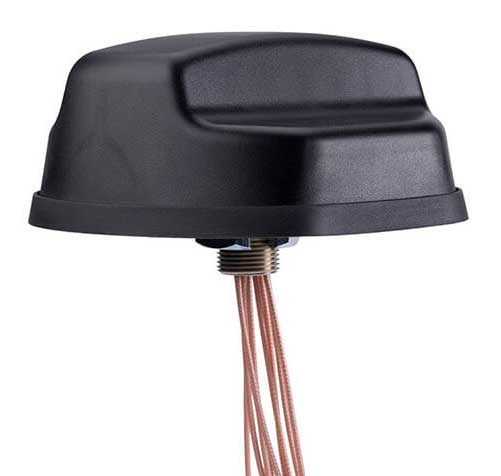
PCTEL Inc. has released an antenna that combines precision multi-constellation GNSS with high-performance LTE, sub-6 GHz 5G, Bluetooth and Wi-Fi connectivity.
The Coach II antenna with GNSS L1/L2/L5 is designed to provide greater precision and reliability for advanced rail communications systems, enabling everything from next-generation positive train control (PTC) to passenger Wi-Fi.
“Precise timing and tracking information is critical not just for rail, but for a variety of fleet, public safety, and industrial IoT [internet of things] applications,” said Rishi Bharadwaj, PCTEL’s chief operating officer. “PCTEL’s antenna technology enables our customers to deploy new technologies with confidence,” added Bharadwaj.
PCTEL is displaying its Coach II antenna with GNSS L1/L2/L5 on Sept. 22-24 at RSSI C&S Exhibition in Minneapolis, Minn. It is available to order now for shipment in early November using part #GL125-DLTEMIMO.
Protection from jamming has emerged as the key concern of of both national and organizational/corporate infrastructures. The world abounds in bad actors, and systems based on GNSS signals are uniquely vulnerable. A basic component of any anti-jamming (AJ) strategy is a shielded antenna. An upcoming webinar, June 27, gives a primer and several advanced looks at developing such an antenna-based AJ campaign. Register here for the complimentary webinar.
Anti-jam antennas use techniques, such as nulling or beam-forming, to mitigate the effects of interfering signals. (Image: Orolia)
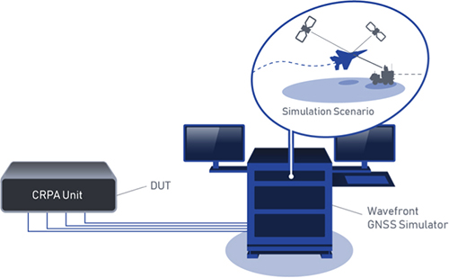
Controlled reception-pattern antennas (CRPAs) are advanced, multi-element antenna solutions that protect a GNSS/GPS receiver from jamming sources. When combined with antenna electronics, they form an anti-jam antenna system (AJAS). These systems utilize several available technologies and vary in the number of elements.
CRPAs will play an increasing role in the GPS/GNSS landscape. Initially developed in the military domain, they are now entering the civilian market and are poised to bring their benefits to the fields of aerospace, ground transportation, autonomous driving and others. Engineers working with GNSS systems that employ CRPAs and multi-element antennas need special test systems since they need to replicate very specific test conditions that are impossible with live signals.
These complex antenna systems require advanced GNSS simulation equipment in order to be designed and validated, as well as to test their performance. These test systems come in two forms — an anechoic chamber system used to test the CRPA antenna over the air, and a wavefront simulator used to test the antenna electronics with a direct cable connection.
Webinar speakers:
Perdue
Lisa Perdue, Product Manager, Orolia. Perdue is an expert in testing critical GPS and GNSS systems. She has trained hundreds of engineers and technicians who are responsible for high-reliability positioning, navigation and timing applications. She took a lead role in the development of the first GNSS Vulnerability Test System and speaks widely on the topic at many industry conferences.
Hamel
Stéphane Hamel, Director, Testing, Orolia. With a career spanning more than 20 years in engineering test and RF, Hamel has developed many innovative and large-scale products to test semiconductor devices, radios and GNSS receivers. In 2014, he founded Skydel, now part of Orolia. Hamel is one of the architects behind the Skydel SDX GNSS simulator.
NovAtel has added the GAJT-410ML to its GPS Anti-Jam Technology (GAJT) portfolio. Designed specifically for rapid integration into space-constrained military land applications, the easy-to-use system protects GPS-based navigation and precise timing receivers, including M-code, from both intentional and accidental interference, the company said.
The GAJT-410ML is the next evolution of NovAtel’s battle-proven anti-jam technology. It maintains the high levels of interference rejection performance as in the larger GAJT-710ML system, but in a lower size, weight and power (SWaP) design.
Photo: NovAtel
Working alongside the GAJT-410ML, the Power Injector Data Converter (PIDCTM) provides access to the jammer status and direction-finding (DF) information. It also provides clean power and data over the same cable that delivers the protected GPS signal back to the receiver, which reduces the need for costly platform modifications. The PIDC can be supplied in either an enclosure or board and is available to license for installation into third-party equipment.
NovAtel Defence Segment Manager Dean Kemp noted, “Building on the success of our existing anti-jam portfolio, the GAJT-410ML is the first system to address the needs of smaller land-based platforms and add situational awareness capability to already high levels of mitigation performance.”
“This product offers more choices for system integrators and end users to protect against GPS denied or constrained situations and delivers on our commitment to provide assured positioning anywhere,” Kemp added.
Learn more about the GAJT-410ML anti-jam antenna or talk with NovAtel’s team of specialists at these upcoming trade shows:
The Special Operations Forces Industry Conference (SOFIC) – May 20 – 23, 2019, Tampa, FL USA
CANSEC – May 29 – 30, 2019, Ottawa, ON Canada
Joint Navigation Conference (JNC) – July 8 – 11, 2019, Long Beach, CA USA
International Defence Industry Exhibition MSPO (Canadian Pavilion) – September 3 – 6, 2019, Kielce, Poland
Defence & Security Equipment International (DSEI) – September 10 – 13, 2019, London, UK
A roundup of recent products in the GNSS and inertial positioning industry from the April 2019 issue of GPS World magazine.
OEM
GNSS receiver
With embedded 9-DOF IMU
Photo: Rokubun
The Argonaut GNSS receiver is able to provide geo-location with real-time accuracy of 2 meters and off-line accuracy better than 0.4 meters using Argonaut PaaS. This is possible because GNSS raw measurements, together with inertial measurement unit (IMU) nine-degrees-of-freedom (9-DOF) measurements, are stored for offline GNSS processing (PPK, RTK, DGNSS). Argonaut will also register external events such as camera triggers within microsecond resolution and decimetric geo-location accuracy. The embedded IMU allows for an increased rate of navigation fixes as well as robust solutions in scenarios with impaired GNSS availability. Rokubun, rokubun.cat
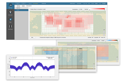
Galileo AltBOC addition
Plus atmospheric corrections
Photo: Skydel Solutions
SDX GNSS simulator update version 19.1 adds Galileo AltBOC signal generation, new atmospheric errors, SBAS improvements and SV antenna patterns. SDX users licensed with the Galileo E5 signal will be able to generate 8 Phase Shift Keying (8-PSK) constant envelope AltBOC after upgrading to SDX 19.1. Version 19.1 also adds a new error type to all SDX users: atmospheric delays. These errors can be compensated for with the SBAS option installed. Skydel Solutions, skydelsolutions.com
Wavefront simulator
Added to software-defined platform
Photo: Skydel Solutions
The BroadSim Wavefront Simulator is a new addition to Skydel’s software-defined platform. The BroadSim Wavefront further extends the capabilities achieved by BroadSim Anechoic, incorporating support for controlled radiation pattern antenna (CRPA) and multi-element receiver testing. Powered by Skydel SDX, the simulator’s features include phase-coherent simulation, real-time automated phase calibration, scalability from 4 to 16 elements, and advanced jamming and spoofing scenarios. Talen-X, www.talen-x.com
GNSS antenna
For high-precision and autonomous applications
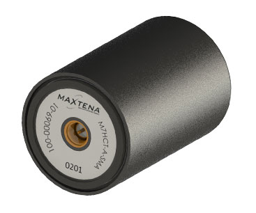
Photo: Maxtena
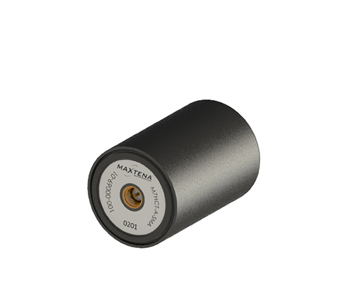
The M7HCT-A-SMA is a high-accuracy, multi-frequency active quadrifilar helix GNSS antenna designed for high-precision and autonomous multi-frequency applications. The design offers concurrent GNSS reception on L1 (GPS, GLONASS, Galileo, Beidou) and L2 (GPS L2C, Galileo E5B and GLONASS L3OC) in a rugged, compact and ultra lightweight form factor. The antenna is designed for GIS, RTK and other high-accuracy GNSS applications such as the drone and automotive markets. Helicore technology provides exceptional pattern control, polarization purity and high efficiency in a 25-gram form factor. The antenna offers up to 30-dB gain for GNSS applications in one radome housing with a single SMA connector. Maxtena, maxtena.com
Portable simulation
Solution for field-test requirements
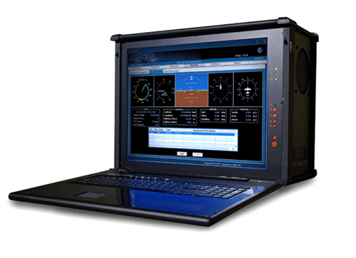
Photo: CAST Navigation
The CAST-1000 duplicates GPS RF signals and uses dual-frequency signal generation technology. This allows for duplicate testing in the laboratory or the field and real-time or configured control. The CAST-1000 is mobile and portable, which makes it the ideal solution for field test requirements. Producing GPS and GLONASS signals with up to 12 satellites in view, the CAST-1000 simulates signals for satellites of P code on L1 and L2 and C/A code on L1. The GPS RF signal is dual-frequency and has a 12-channel configuration for any combination of visible space vehicles. The system is highly programmable — operators can choose from an array of vehicle types and replicate dynamic motion for all kinds of vehicles, from terrestrial to aquatic, airborne to space-based. By utilizing 6-DOF dynamic profile data collected in the field and through profile configuration, a trajectory can be created. The CAST-1000 also features a performance evaluation module, allowing for comparisons between raw and filtered data. CAST Navigation, www.castnav.com
Survey & Mapping
Graphing software
New plotting features
Photo: Golden Software
Version 14 of the Grapher scientific graphing package offers new plotting and customizing functionality based on user feedback. The Grapher software gives users deeper insights into their data by providing them with 80 flexible and easy-to-use 2D and 3D graphing tools for plotting, analyzing and displaying scientific data sets. The package is used extensively by scientists and engineers in oil & gas operations, hydrologic/geochemical studies, environmental consulting, mineral exploration and academic research. New or upgraded features include Enhanced Plotting (the ability to plot data in rows and columns, perform one-button Durov class plots, and easily generate multi-plot reports); and Improved Bar Charts (bar charts are more versatile, offering variable bar widths and differentiated fill colors for negative and positive). Golden Software, www.goldensoftware.com
GIS software update
New lidar functionality
Photo: Blue Marble Geographics
Global Mapper version 20.1 offers new and updated geospatial tools, as well as performance improvements throughout the application. Enhancements to version 20.1 include a new zooming function in the path profile window, a digitizer tool for automatically closing gaps between features and, for lidar module users, a point proximity query function. Blue Marble Geographics, www.bluemarblegeo.com
Survey application
For the geospatial industry
Photo: Global GNSS
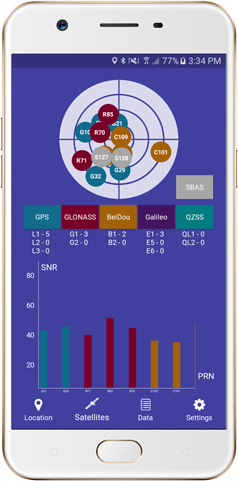
The GNSS Surveyor mobile application provides location information and quality position data in real time with sub-meter to centimeter accuracy. It connects to any external GNSS receiver via Bluetooth. Features include a one-touch configured command to communicate directly with the GNSS Bluetooth device; location information and quality of the position data in real time with centimeter accuracy; GPS data such as position, height, satellites and velocity; and constellation information for GPS, GLONASS, Galileo, BeiDou, QZSS and SBAS satellites. It also includes a direct IP feature for real-time kinematic (RTK) corrections data. An internal NTRIP client loads RTCM data from the internet. Location information is collected as latitude and longitude, altitude, speed or pace, bearing and UTC time. GNSS precision includes global coverage, centimeter-level accuracy, fast time to first fix, multi-constellation and multi-band, and highest security. Navigation uses include ground robotics navigation, lane-level navigation, heavy machine navigation, industrial navigation and tracking, and commercial UAV. Global GNSS, globalgnss.com
Indoor mapping
Slam technology removes point cloud artifacts
Photo: NavVis
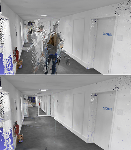
The SLAM-based NavVis M6 Indoor Mobile Mapping System (IMMS) now automatically detects and removes point cloud artifacts, including moving objects in static scenes. The latest IMMS release removes artifacts from point clouds during the post-processing of scan data (see before and after image above). Fringe points and dynamic objects are two common types of point cloud artifacts that affect all 3D laser scanning devices. The NavVis M6 IMMS uses laser scanners to capture a high volume of measurement points of an environment. With the latest software update, the algorithms applied during the post-processing of scan data uses the multiple observations to detect whether measurement points actually exist in the physical space. If it is determined that the point does not exist and is instead resulting from the laser beam hitting an edge or an object moving through the space, this point is automatically removed. The result is a much cleaner, crisper point cloud that requires less clean-up time in point-cloud editing software and that is easier to use for applications such as BIM modeling. NavVis, www.navvis.com
Mobile & UAV
Adventure handhelds
Larger display, improved access to Satellite imagery
Photo: Garmin
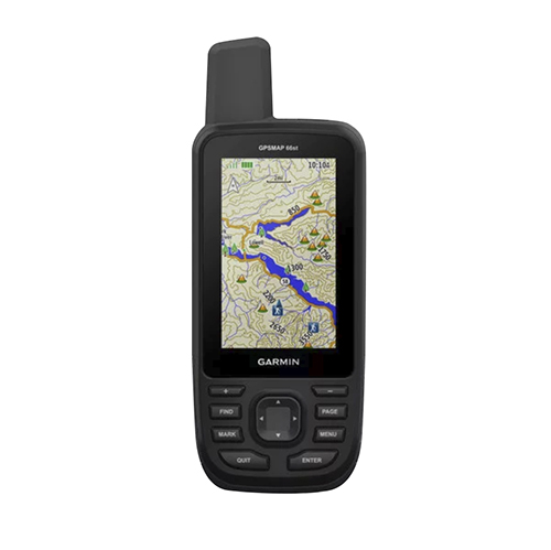
Garmin has updated two premium adventure-oriented handhelds, the GPSMAP 66s and the GPSMAP 66st, with expanded wireless connectivity, direct-to-device access to BirdsEye satellite imagery, weather forecasting and a larger 3-inch sunlight-readable color display. The GPSMAP 66st offers preloaded topographic maps for U.S. and Canada, with detail of coastlines, rivers, summits, terrain contours and geographical points. Connectivity to the new Garmin Explore app and the BirdsEye Satellite Imagery (no annual subscription) bring high-resolution photo-realistic route views. Weather updates come via Bluetooth to a compatible mobile device. The Explore app includes features for outdoor navigation, trip planning, mapping and data sharing. Features include multi-GNSS satellite support and altimeter, barometer and compass sensor capabilities; 16 hours of battery life in full GPS mode; LED flashlight and SOS beacon; built to military standards for thermal, shock and water performance (MIL-STD-810G); RINEX data logging that enables sub-meter accuracy of GPS position after post processing. Garmin, garmin.com
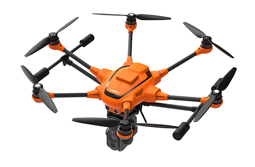
RTK Hexacopter
Integrated GNSS improves accuracy
Photo: Yuneec International
The H520 hexacopter is now available with a real-time kinematic (RTK) system. The fully integrated RTK satellite navigation enables extremely accurate recurring images and faster 3D mapping. It also makes automated inspection flights easier and more precise. The H520 RTK is suitable for commercial applications that require maximum precision. By using RTK technology, the H520 can now fly much closer to objects for inspection because the UAV positions itself precisely in the centimeter range (1 cm + ppm horizontal / 1.5 cm + ppm vertical) rather than in the meter range, which is standard for the H520. Yuneec International, us.yuneec.com
Web-based data service
Enables sharing of UAV data sets
MAGNET Collage Web is a web-based service enabling the sharing and collaboration of UAV and scanning data sets. Version 1.3 allows operators to work with more types of data with greater flexibility, including the ability to import BIM models, as well as CAD and GIS data. It can be used to overlay as-built laser scans and design data to visualize proposed changes and detect construction issues. The software supports OBJ, FBX and 3DS formats. The upgrade also includes new direct publishing functionality for CAD and GIS data files through the browser. Topcon, topconpositioning.com
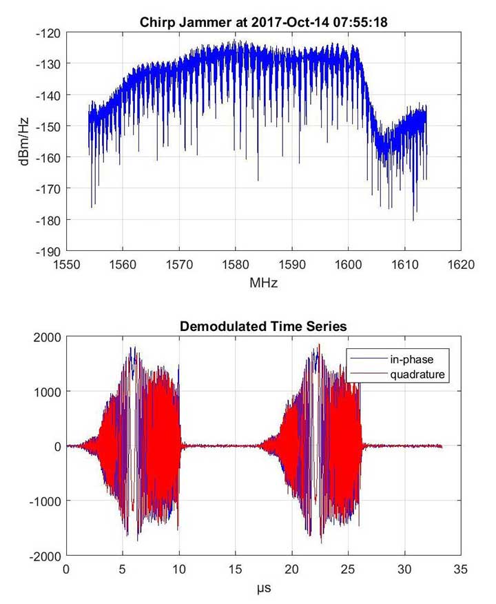
Recent years have seen an increase in drivers turning to cheap GNSS jamming devices in order to move around undetected or to thwart built-in anti-theft systems or road tolling systems. These jammers not only knock out their own GNSS receiver, they also block GNSS signal reception in a radius of several hundred of meters.There is a growing demand for automatic detection of these illegal jammers to help catching the offending driver.
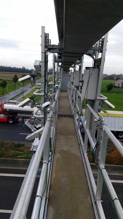
Septentrio GNSS antenna placement on highway gantry. (Photo: Septentrio)
An ION GNSS+ 2018 presentation by Wim de Wilde and Jean-Marie Sleewaegen presentation showed how a multi-antenna GNSS receiver with built-in RF spectrum monitor and adequate processing tool can efficiently detect and classify jamming events and identify the offending car or truck. They conducted a five-day test with two Septentrio AsteRx-U dual-antenna receivers installed on an overhead structure above a busy highway.
In parallel to the GNSS tracking and built-in anti-jam functionality, the AsteRx-U can simultaneously sample the RF signal from its two antennas. One of the objectives of the test was to evaluate the possibility to perform lane detection by cross-correlating the jamming signal received by the two antennas. In addition, the antennas were mounted with a significant inclination angle to create an asymmetrical reception pattern.
The goal was to assess the feasibility of detecting the driving direction from the time series of the received jammer power. Such lane or direction detection would greatly help identifying the offending driver in heavy traffic conditions when more than one vehicle crosses the overhead structure at the time of the jamming.
Over the five days of the experiment, 45 jamming events were recorded and analyzed, most of them intentional: continuous wave, chirp or even less-known pulse jammers.
Chirp jammer example. (Charts: Septentrio)
The researchers explained how the jamming events are automatically detected and classified by the processing tool, using pattern recognition to distinguish between intentional harmful events and unintentional interferences. They presented selected cases illustrating the RF signature of the most prevailing types of jammer.
They then addressed the direction and lane sensing algorithm and discussed the effect of multipath propagation of the jammer signal. All algorithms are illustrated with real-life examples.
A roundup of recent products in the GNSS and inertial positioning industry from the March 2019 issue of GPS World magazine.
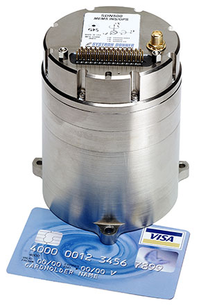
MEMS INS/GPS
Update improves heading performance and reduces jitter
Photo: Systron Donner
The SDN500 digital quartz micro-electro-mechanical systems (MEMS) GPS inertial navigation system (GPS/INS) has been updated. Model SDN500-xE provides a newer generation JF2 (C/A) code GPS receiver and tightly couples the 1 PPS GPS signal to the SDI505 IMU synch pulse to improve heading performance and reduce jitter after long periods of operation without dynamic inputs. The 25-inch-square SDN500 provides for maximum packaging flexibility in dense systems and delivers accuracies to within 1.0 mrad in attitude, 0.1 m/s in velocity and 3.9 meters spherical error probability (SEP). It offers tactical-grade performance, integrating SDI’s latest quartz gyros capable of 0.5°/hr. bias in-run stability and low angular random walk (ARW, 0.02°/√ hr), quartz accelerometers delivering 0.5 milli-g in-run bias stability and low velocity random walk (VRW, 80 µg/√ Hz), plus high-speed digital signal into a tightly coupled GPS/INS for tactical navigation and geo-location applications.
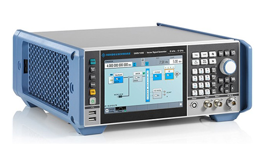
Testing location accuracy performance of mobile devices
Photo: Rohde & Schwarz
To create test concepts for over-the-air (OTA) antenna measurements, Rohde & Schwarz and Bluetest have integrated the R&S LBS Server, a software component running on the R&S CMW500 wideband radio communication tester, and the Bluetest over-the-air (OTA) test solution for A-GNSS systems based on Bluetest’s RTS65 reverberation chamber and Bluetest’s Flow measurement software. The R&S LBS Server controls the Rohde & Schwarz base-station simulator R&S CMW500 for LTE, WCDMA and GSM, and uses the R&S SMBV100B vector signal generator for simulation of GNSS and metropolitan beacon systems (MBS) signals. An upgrade for 5G will be available soon. The R&S LBS Server is an essential part of the R&S TS8991 OTA Performance Test System.
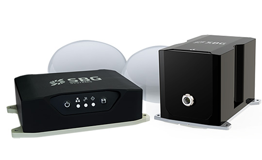
Brings Navsight technology to the most demanding environments
Photo: SBG Systems
The Horizon IMU adds a third choice to SBG System’s Navsight Land/Air Solution. It is a FOG-based high-performance inertial measurement unit (IMU) designed for highly demanding surveying applications such as high-altitude data collection or mobile mapping in dense areas such as urban canyons. The Horizon IMU joins the Ekinox and Apogee IMUs as options for Navsight. The different levels of accuracy enable the solution to meet various application requirements and can be connected to various external equipment such as odometer, lidar and more. The Horizon IMU allows customers to use Navsight in high-altitude and highly dense areas, as well as where only a single antenna can be used. It is based on closed-loop FOG technology that enables ultra-low bias and noise levels. The Navsight solution can be installed in a plane or car — the sensor alignment and lever arms are automatically estimated and validated. The Navsight unit also integrates LED indicators for satellite availability, real-time kinematic (RTK) corrections and power. Qinertia post-processing software provides access to offline RTK corrections from more than 7,000 base stations in 164 countries.
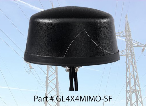
The Coach 4×4 Wi-Fi/DSRC GNSS multi-band antenna enables smart grids, mobile workforce communications, and advanced automation technologies. The dual-band 802.11ac/p MIMO antenna helps boost data rates and reliability for utility networks, intelligent transportation systems and other industrial internet of things (IoT) applications. The low-profile antenna features four-port 2.4/5-GHz coverage along with PCTEL’s high-rejection GPS/GLONASS technology for network timing and tracking in a single IP67-rated housing.
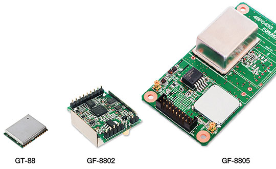
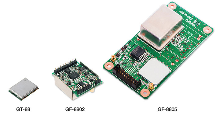
Furuno Electric Co. Ltd., based in Nishinomiya, Japan, has developed the GT-88 timing module and GF-8801/02/03/04/05 disciplined oscillator for users who require UTC time-synchronized signals to meet the new 5G requirements.
They provide UTC time-synchronized timing signals (1 PPS/10 MHz) by receiving GNSS satellite signals. Achieved stability is better than that of an atomic clock, including a rubidium.
Photo: Furuno
The GT/GF-88 series includes a brand-new algorithm, named Dynamic Satellite Selection, that provides outstanding multipath mitigation, especially in urban canyon environments, the company said. The algorithm was developed by Nippon Telegraph and Telephone Corporation (NTT) based in Tokyo, Japan.
Extremely high stability of 4.5 ns (1 sigma) is obtained, only requiring reception of the L1 band (1575.42 MHz) frequency GNSS satellites. It was achieved by improving advanced position estimation algorithms and optimizing position calculation among several different GNSS satellite constellations. It allows users to achieve 5G-required performance without any changes to existing single-band GNSS antennas.
It incorporates the Dynamic Satellite Selection, an advanced multipath mitigation algorithm developed by NTT. Normally typical time synchronization performance deteriorates in urban canyon environments by the effect of multipath. The Dynamic Satellite Selection reduces this time error by one-fifth. This provides more flexibility when installing GNSS antennas. Consequently, the GT/GF-88 series now permits GNSS antennas to be mounted on walls, windows of tall buildings and other difficult reception environments.
The GT/GF-88 series continues to support GPS, GLONASS and QZSS satellite constellations, and now adds Galileo support. As the total number of satellites available increases, operational stability also increases.
Maxtena Inc. has introduced a patented GNSS antenna designed for high-precision and autonomous multi-frequency applications. The M7HCT-A-SMA antenna is a high-accuracy, multi-frequency active quadrifilar helix GNSS antenna.
Photo: Maxtena
Maxtena is a U.S.-based antenna design and manufacturing company and inventor of the patented Dynamic Aperture Technology.
The new design will offer concurrent GNSS reception on L1: GPS, GLONASS, Galileo, Beidou and L2: GPS L2C, Galileo E5B and GLONASS L3OC in a rugged, compact and ultra lightweight form factor.
The antenna is designed for GIS, RTK and other high-accuracy GNSS applications such as the drone and automotive markets, where high performance and low weight are driving features in antenna selection.
The M7HCT-A-SMA active helix design features Maxtena’s patented compact and lightweight Helicore technology. This technology provides exceptional pattern control, polarization purity and high efficiency in a very compact form factor.
The antenna offers up to 30-dB gain for GNSS applications that utilize GPS, GLONASS, Galileo and Beidou, in one radome housing with a single SMA connector.
The M7HCT-A-SMA will join Maxtena’s line of rugged GNSS helix antennas that are ultra lightweight, small, and precise. The M7HCT-A-SMA weighs 25 grams and is housed in automotive grade PCB plastic with automotive grade electronics and is rated IP67 when mounted.
It is ground plane independent and offers extremely low power consumption and minimal phase-center variation over azimuth. The antenna offers superb axial ratio ensuring multipath error is mitigated.
“Maxtena is very excited to be launching a game-changing antenna for the UAV, drone, and automotive markets, and really for any application requiring a high performance, lightweight antenna that can cover so many frequencies. It is the most robust antenna solution on the market,” said Maxtena Vice President of Sales and Marketing Vanja Maric.
New developments in antenna technology empower the final positioning solution with better accuracy and reliability. Leading experts discuss the technology advances producing greater user benefits.
The increasing prevalence of both intentional and inadvertent jamming, new wider bandwidths, and the significance of antenna phase-center variation all bring changes to the dynamic and evolving antenna sector.
Javad Ashjaee (Photo: Javad GNSS)
Javad Ashjaee
President & CEO, JAVAD GNSS
Advanced filtering techniques enable our antennas to defend against jammers and spoofers and to inform users with the details of these intrusive actions when they are detected.
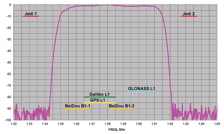
Near-Band Interference. The J-Shield is a robust filter in our antennas that blocks out-of-band interference, in particular such signals that are near the GNSS bands like the LightSquared/Ligado signals. The graph below shows the protection characteristics of the J-Shield filters. It has a sharp 10-dB/KHz skirt that provides up to 100 dB of protection. It makes the precious near-band spectrums available for other usages and protects GNSS bands now and in the future.
In-Band Interference. Our in-band protection digital filter protects against in-band interference like harmonics of TV and radio stations when you get close to them, or against illegitimate in-band transmissions. Our in-band interference protection is based on the 16 adaptive 80th-order filters. Advanced interference mitigation (AIM) filters can be combined in pairs for complex signal processing. This filter can simultaneously suppress several interference signals.
Graph: Javad GNSS
The 16 finite impulse response (FIR) AIM filters can be combined in any number in chain. Each filter is a 255-order FIR filter. It can be used to suppress the stationary interference signal in programmable area (compare with adaptive AIM-filter) or for spectrum shaping. To have more suppressing areas or more aggressive suppressing, one can combine FIR AIM serial.
Neil Gerein, Portfolio Manager, NovAtel. (Photo: NovAtel)
Neil Gerein
Director, Product Management, NovAtel
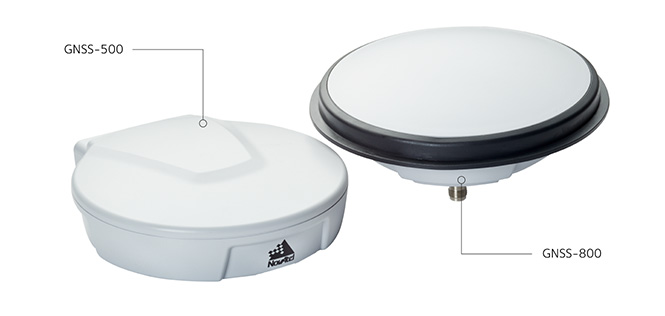
At NovAtel we often say, “accuracy is addictive,” and to meet increasingly demanding accuracy and reliability requirements it is vital to concentrate on the antenna. After all, the antenna is the first in a long chain of key technologies that the GNSS signals must pass through to create a position, navigation and timing solution.
All modern GNSS transmit on multiple frequencies, with wide bandwidth signals, requiring antenna elements and integrated low noise amplifiers (LNAs) that operate across these frequencies. The challenge is to design the antenna element and LNAs for symmetric radiation patterns across all frequencies while minimizing multipath, phase center offset (PCO) and phase center variation (PCV). The result is better carrier-phase measurements, and therefore more accurate solutions in real-time kinematic (RTK) and PPP applications.
Photo: NovAtel
Since 2016 the Radio Equipment Directive (RED) has been in effect, and all GNSS receiver systems sold into the European Union must be compliant to the standard, including adjacent-band compatibility and spurious emissions testing. RED compliance is an end-to-end system test, where the filtering within the antenna must be analyzed in concert with the filtering capabilities of the connected GNSS receiver to meet the requirements. The antenna performance therefore becomes critical to any GNSS receiver system that is intended to be sold within the EU.
Gyles Panther, president and CTO, Tallysman Wireless. (Photo: Tallysman)
Gyles Panther
President and Chief Technical Officer, Tallysman
A fact often not appreciated is that the performance of a GNSS antenna is commonly the limiting factor in system accuracy. Digital signal algorithms in the receiver are helpful, but if the signal delivered by an antenna is less than optimum, the receiver cannot compensate.
Precision GNSS systems typically rely upon resolved wavelength ambiguity measurements, combined with ephemeris and clock corrections to determine signal time of flight. In real-time kinematic (RTK) and precise point positioning (PPP) receivers, the basis for this measurement is phase locked tracking of received satellite signals. Thus an over-arching measure of antenna performance in the specific application conditions is the proportion of the time that phase lock is maintained by the receiver.
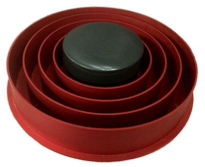
The VeraChoke GNSS antenna. (Photo: Tallysman)
All this provides for an unprecedented level of accuracy, with precision antennas now more akin to the ends of a tape measure than providing a simple GNSS “fix.” To this end, key parameters include a best possible G/T ratio, high multipath rejection, excellent axial ratio, high front-back ratio and minimal phase-center variation (PCV), all with high uniformity in the azimuth — altogether a very demanding design task.
Combining these parameters to provide exquisite accuracy, the Tallysman VC6100 choke ring antenna has less than 1 millimeter PCV when combined with absolute calibrated corrections data, whilst the lower cost VP6000, with its less complex installation, can be used without corrections data and still be within a millimeter or two of the truth compared to its more precise cousin.
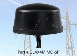
PCTEL Inc. released at DistribuTECH a new dual-band 802.11ac/p MIMO antenna that helps boost data rates and reliability for utility networks, intelligent transportation systems and other industrial IoT (IIoT) applications, according to the company.
PCTEL’s Coach 4×4 Wi-Fi/DSRC GNSS multi-band antenna is designed for both mobile and fixed deployments, enabling smart grids, mobile workforce communications, and advanced automation technologies across a variety of industries.
The antenna also supports Dedicated Short Range Communications (DSRC), a common interoperable safety standard for vehicles.
“PCTEL’s latest antenna will enable the future of the IIoT,” said Rishi Bharadwaj, PCTEL COO. “For example, advanced smart grids utilizing Coach antennas could reduce outages and efficiently manage alternative energy sources.
“Coach antennas also provide mobile connectivity for applications such as DSRC, which has the potential to revolutionize road safety. Those are just some of the possibilities. PCTEL’s advanced RF design and environmental testing capabilities enable us to deliver superior 4×4 MIMO performance and exceptional durability for the most demanding applications,” added Bharadwaj.
This new low-profile antenna features four-port 2.4/5-GHz coverage along with PCTEL’s unique high rejection GPS/GLONASS technology for network timing and tracking, all in a single IP67-rated housing.
It supports a variety of wireless technologies, including broadband mesh networks, 802.11ac Wi-Fi and 802.11p DSRC Wireless Access in Vehicular Networks (WAVE) standards for direct vehicle-to-vehicle (V2V) and vehicle-to-infrastructure (V2I) communications.
This is the latest in PCTEL’s Coach antenna series. Coach antennas have been deployed in a variety of mobile and IIoT applications around the world. Their UV-stable design facilitates maximum installation flexibility without antenna orientation restrictions, the company said.
PCTEL is displaying its Coach4x4 Wi-Fi/DSRC GNSS multi-band antenna Feb. 5-7 at DistribuTECH, booth 11750, in New Orleans. It is available now to order using part #GL4X4MIMO-SF.
Taoglas, a provider of internet of things (IoT) and automotive antenna and RF solutions, completed its acquisition of ThinkWireless Inc., an antenna provider that specializes in the design, development and production of combination antenna systems for the commercial vehicle market.
The ThinkWireless brand will become ThinkWireless, a Taoglas company. ThinkWireless Founder and Chief Executive Officer Argy Petros and Director of RF Technology Pierre Wassom will remain.
“Think Wireless has made a name for itself as a designer and developer of high-quality combination antenna systems with deep roots in the commercial trucking industry, where infotainment services, including good quality of service from satellite and AM/FM radio, weather band and GNSS are crucial,” said Ronan Quinlan, Co-CEO, Taoglas.
“As we continue to explore potential acquisitions to strengthen the Taoglas brand, we were struck by how similar Think Wireless’ approach to antenna design and manufacturing is to our own commitment to excellence,” Quinlan said. “This is a great acquisition for the Taoglas Group as we look to further expand into new, synergistic markets such as the commercial vehicle industry.”
ThinkWireless, headquartered in Coconut Creek, Florida, specializes in the design, development and production of combination antenna systems that incorporate two or more frequency bands, including those for SiriusXM satellite radio, GPS, AM/FM, weather band, DAB, HDTV, Wi-Fi, Bluetooth and LTE.
The ThinkWireless facilities will become Taoglas’ ninth design and development center globally, and the third in the U.S., alongside centers in San Diego and Minneapolis.
“Taoglas is well-known as a global brand that delivers the highest-quality antennas and RF solutions to the automotive, IoT and other markets,” Petros said. “Taoglas’ global scale and sales channels are unparalleled and will help grow the reach of ThinkWireless’ solutions in the trucking and commercial vehicle industry around the world.”
The ThinkWireless antennas will be available for purchase on the Taoglas website, through key distribution partners and through Taoglas’ Antenna Builder e-commerce marketplace for custom antennas and cable assemblies.
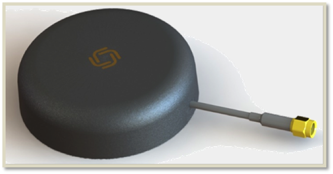
Allystar Technology Co. Ltd., headquartered in Shenzhen, China, is offering new patch antennas: the AGR6302 and AGR6303. Both GNSS antenna models are designed for precision dual-frequency positioning.
AGR6302 is capable of receiving L1/L2 bands, and AGR6303 is capable of receiving L1/L5 bands. They are designed for UAVs, precision agriculture, autonomous vehicles and other applications where precision matters.
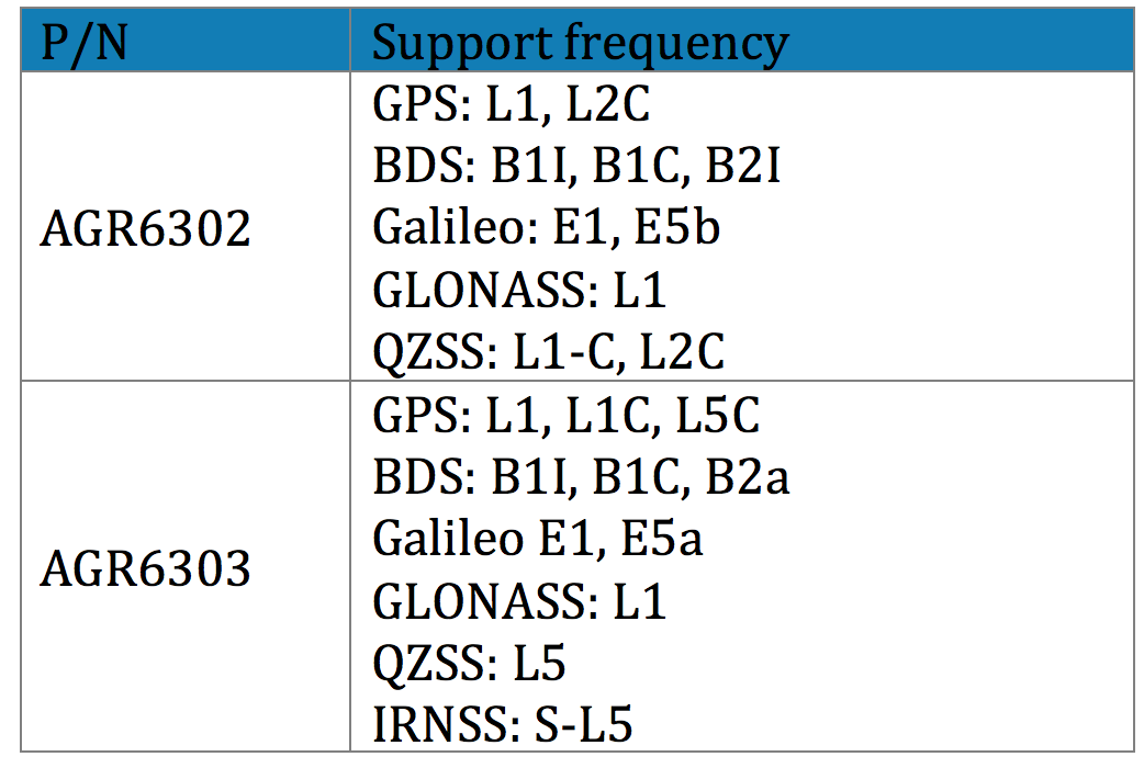
The AGR6302/AGR6303 active antenna is designed by unique technology to cover GPS, BDS, Galileo, GLONASS, IRNSS and the QZSS system (see table).
Table: Allystar
The antenna features stable signal quality at low cost. It employs a stack four-feeds antenna architecture with hybrid to achieve the multi-band operation, lower axial ratio, wider half-power beamwidth and excellent right-hand circular polarization, the company said.
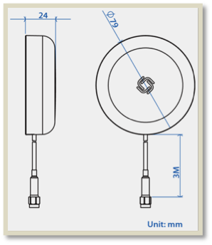
Antenna size. (Image: Allystar)
With its new architecture, the active part has two stages. It has two level low noise amplifiers (LNAs) —one for the lower bands, the other for the higher bands. Then, the combiner and the third-level LNA output the RF gain to receiver. With this architecture, the antenna provides an excellent noise figure/RF linear and LNA gain, and out-band rejection, resulting in good signal-to-noise ratio and anti-interference.
It is housed in a compact, industrial-grade waterproof and magnet mount enclosure. Using internal magnets, the antenna can be installed almost anywhere, allowing for greater flexibility.