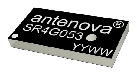
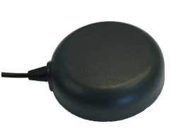
Antenova Ltd. has developed a new positioning antenna that it says can pinpoint a location to within centimeters in the GNSS bands. Antenova is a manufacturer of antennas and RF antenna modules for machine-to-machine and the internet of things.
Antenova will be showing samples of the Raptor antenna at the Consumer Electronics Show, being held Jan. 8-11 in Las Vegas, in booth #2220 in the Westgate hall.
The Raptor antenna utilizes the L2 1200-MHz satellite band that recently became available for civilian use.
The addition of the L2 frequency band combines multi-band satellite signal reception and GNSS correction data. This helps to mitigate position errors, greatly improving accuracy, especially in urban areas, the company said.
As well as improving tracking, the L2 band is beneficial for UAVs, drones, autonomous vehicles, agriculture, grid mapping and other emerging applications, Antenova added.
The antenna is the latest addition to Antenova’s lamiiANT range of rigid FR4 antennas which are designed for easy insertion onto a printed circuit board (PCB).
The antenna itself is very small. It is a GPS single-feed antenna in surface mount (SMD) form, measuring 16.0 x 8.0 x 1.6 millimeters, suitable for small PCBs within all kinds of small electronic devices.
“This is an outstanding antenna, because it achieves the same precision as a much larger, heavier ceramic patch antenna, but in a very compact SMD part,” said Colin Newman, CEO of Antenova. “A ceramic antenna would need to be 35 x 35 millimeters to achieve a similar level of accuracy and performance.” Raptor is supplied in tape and reel for ease in high-volume manufacturing applications.
NovAtel’s GPS Anti-Jam Technology (GAJT) now rides into battle and military exercises aboard the Canadian Army’s Artillery Observation Post Vehicles (OPV) that have been fitted with the GAJT‑710ML antenna.
OPVs are highly mobile vehicles that perform observation, reconnaissance and patrolling missions, surveying and acquiring strategic targets and relaying instant, accurate target coordinates acquisition to artillery fire command systems. With their exposed position on the frontlines of the battlefield, OPVs can encounter severe GPS jamming aimed at crippling their capabilities. OPVs require reliable Position, Navigation and Timing (PNT) not only to safely and effectively navigate on the battlefield, but to provide reliable information to artillery in the rear.
GAJT provides protection for GPS navigation and precise timing receivers from intentional jamming in electronic attacks, ensuring that the satellite signals necessary to compute position and time are always available.
“GAJT allows us to have confidence that the position information from the GPS constellation is assured.” said Major Mike Moulton, the project manager in the Directorate of Land Communication Systems Program Management.
NovAtel’s GAJT is a retrofittable system. A military-off-the-shelf (MOTS) product, it comes in versions suitable for land or sea applications and smaller platforms such as unmanned aerial vehicles (UAVs). The antenna works with an array of military and civil receivers, including the Army’s handheld Defense Advanced GPS Receiver (DAGR), other military receivers using SAASM and M-Code, and with civil receivers.
“GAJT scrubs off unwanted signals. It differentiates between what we can recognize as a signal coming from a satellite and something anomalous, which could be interference or deliberate jamming,” explained Peter Soar, NovAtel’s Business Development Manager for defence. “GAJT does not contain a GPS receiver, but works with the receiver that’s already installed. So GAJT faithfully passes the good satellite signals to the receiver which then operates functions such as integrity monitoring in its normal way. GAJT is in use operationally and has been shipped to 16 allied nations around the globe.”
GAJT is a null-forming antenna system that ensures that satellite signals necessary to compute position and time remain available. There is no need to replace the GPS receiver that’s already installed, as GAJT works with both civil and military receivers operating in the GPS L1 and L2 bands. It is ready for M-Code, is a non-ITAR product and is readily available to authorized customers.
Trials with the Canadian Army’s testing unit validated the technology, maintaining access to the GPS signal in an adverse signal environment. It also gave NovAtel engineers a detailed unclassified report on the trial findings and recommendations. The feedback helped NovAtel modify GAJT into a stronger product. The GAJT-710ML antennas were delivered earlier this year, and the Army worked with General Dynamics Missions Systems Canada, the prime contractor for the mission systems on the OPV, to integrate the antenna aboard the vehicle.
“GAJT is a Canadian success story. It is 100 percent produced in Canada and sourced from Canadian components. I think that the Directorate of Land Communication Systems Program Management have shown there is excellent technology in Canada that can be leveraged to meet the Army’s requirements in a very rapid manner,” added Moulton.
This story uses some quotes that first appeared in “Out of a Jam,” an article by Chris Thatcher in Canadian Army Today.
Tallysman, a manufacturer of high-performance GNSS antennas and related components, has introduced a high-accuracy choke ring antenna: the Tallysman VeraChoke.
Adapting existing innovations on its patented VeraPhase antenna, Tallysman’s VeraChoke offers a choice in form factor for reference and monitoring applications.
The VC6100, the first model variant of the VeraChoke antenna, shares a common high-efficiency element design with itsVeraPhase counterpart. With the choke-style form-factor, however, the rings have been optimized for all GNSS signals and are slightly pyramidal in shape to improve reception of low-elevation satellites.
The VC6100 choke ring antenna offers a tight phase center variation of no more than ±1 mm for every frequency. It is capable of receiving all GNSS signals and achieves a very low axial ratio, the company said.
According to Tallysman, the VC6100 is competitively priced to help increase antenna density for reference deployments, CORS networks and monitoring applications. The antenna also supports large and small SCIGN radomes.
Tallysman’s GNSS antennas are on display at Booth Number 12.0D.059 at Intergeo, taking place Oct. 16-18 in Frankfurt, Germany.
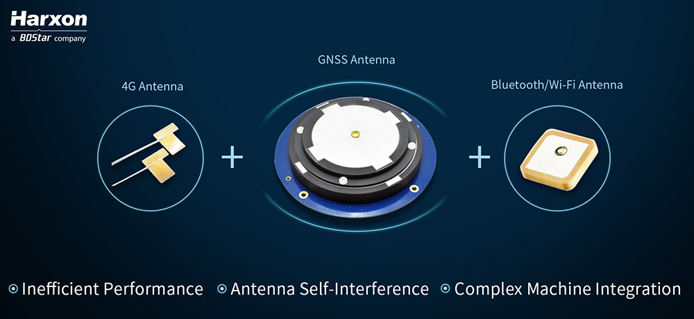
Harxon is showcasing high-precision positioning GNSS antennas and its latest wireless data transmission technologies for surveying applications at Intergeo, Oct. 16-18, in Frankfurt, Germany.
Image: Harxon
X-Survey is an 4-in-1 OEM antenna for both navigation and communication in the real-time kinematic (RTK) surveying applications. It provides standard Wi-Fi, Bluetooth, 4G, and multiple-constellation signal reception for GNSS positioning.
Its 3D design ensures a higher phase center stability and longer communication distance at a 360-degree direction, while lowering the impact of electromagnetic interference (EMI), hence increasing the overall machine efficiency and simplifying the RTK integration, the company said.
Photo: Harxon
The smart eRadio is a long-range and highly efficient radio modem designed to support RTK applications in surveying and precision agriculture. It can automatically identify RTK serial baud rate and provide a plug-and-play form for easy connection between eRadio and RTK.
According to Harxon, the eRadio’s diagnostic reporting software can configure data and update radio status, allowing users to effectively deal with potential issues. In addition, it is equipped with the unique ETALK communication protocol that increases the communication distance by 20 percent.
Other Harxon GNSS products showcased at Intergeo are for UAVs and precision agriculture, as well as surveying.
The D-Helix antenna HX-CHX600A is featured with its patented D-QHA technology.
Both 3D structured and mini-designed choke-ring antennas HX-CGX601A and HX-CGX611A can be used for base-station communication.
The multi-constellation survey antenna GPS 1000, frequency hopping modem HX-DU2017D and external radio modem HX-DU8608D are also popular products for high-precision performance.
Allystar’s Yi Fen Tseng discusses the company’s HD9300 series precision positioning Cynosure III GNSS chip and high precision GNSS family at ION GNSS+ 2018, which took place in Miami. According to the company, the HD9300 series is a highly integrated GNSS receiver chip based on its Cynosure III architecture, integrating multi-band, multi-system, GNSS, RF and baseband. In addition, the company showcased its A GR6301 single-band GNSS antenna and A GR6302/A GR6303/A GR630X high-precision dual-band GNSS antenna.
PCTEL Inc. will demonstrate its next generation of multi-band, multi-network 4G LTE antennas at InnoTrans 2018 for the transit and rail industries, which takes place Sept. 18-21 in Berlin.
PCTEL’s new Trooper II and Coach II dual-carrier antenna platforms are designed to meet the requirements of increasingly complex RF communication systems in transportation applications.
The Trooper II antenna. (Photo: PCTEL)
Both Trooper II and Coach II antennas feature four 4G LTE antenna elements, and four 802.11ac Wi-Fi MIMO elements compatible with the world’s leading multi-network cellular routers.
The antennas support carrier aggregation for high-speed data transmissions in dense RF environments, such as transit depots and rail stations.
They also incorporate PCTEL’s proprietary high-rejection multi-GNSS technology for high precision tracking and asset management. Both platforms are housed in attractive low-profile housings and can be easily installed on all types of mass transit vehicles, or even fixed surfaces, the company said.
“PCTEL has a strong portfolio of products for rail and mass transit applications,” said Rishi Bharadwaj, PCTEL’s COO. “Our products have been qualified and deployed by major railroad equipment manufacturers and operators for over a decade. We are excited to showcase our industry-leading technology and capabilities at InnoTrans.
“High-performance antennas play a crucial role in the implementation of wireless technologies to improve safety and operational efficiency,” Bharadwaj said. “PCTEL’s innovative MIMO antenna technology also enables transit operators to deliver a better passenger experience through more reliable high-speed internet access.”
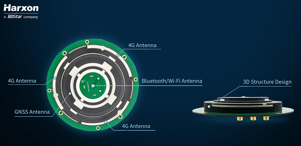
Real-time kinematic (RTK) integration usually uses separate antennas, which can lead to reduced efficiency because of electro-magnetic interference (EMI).
Image: HarxonImage: Harxon
Also, conventional antenna installation can result in unstable machine performance because of the problems of system compatibility between different antennas.
Harxon has overcome those difficulties with its integrated X-Survey antenna, a 4-in-1 OEM antenna for both navigation and communication in surveying applications.
It provides standard Wi-Fi, Bluetooth and 4G, plus multiple constellation signal reception for GNSS positioning.
The high-gain and wide-beamwidth GNSS antenna features a multi-point feeding technology, ensuring a high phase-center stability and positioning accuracy, the company said. Moreover, the array-arranged 4G antennas enables more stable signals and longer communication distance at 360-degree direction, increasing the overall machine efficiency over conventional antennas.
The X-Survey antenna provides high isolation among each antenna to prevent self-interference, improving RTK system compatibility. RF coaxial connectors are designed for plug-and-use, keeping high efficiency and lowering the impact of EMI.
The antenna low-noise amplifier features excellent out-of-band rejection performance, which can also suppress the EMI, providing reliable GNSS signals.
The unique structure design simplifies RTK integration, and minimizes the overall machine dimension. Harxon aims to bring system integrators high-efficiency performance of navigation and communication in surveying and precision agriculture applications.
4G bands can be customized according to different countries and regions, the company added.
U-blox, a global provider of positioning and wireless communication technologies, has released the ANN-MB multi‑band active GNSS antennas, tailored specifically to the needs of applications requiring centimeter-level positioning accuracies.
The ANN-MB series. (Photo: u-blox)
ANN-MB offers product designers an easy-to-implement and reliable multi-band antenna solution, u-blox said. It is designed for small- to medium-size customers with little experience with GNSS antennas who would like to accelerate their time to market.
The ANN-MB antenna series builds on u‑blox’s two decades’ worth of experience with high-performance antennas for GNSS receivers. Developed in conjunction with the recently announced u‑blox F9 multi-band high precision positioning platform, ANN‑MB receives signals on the L1 and L2/L5 bands of all four global navigation satellite constellations (GPS, GLONASS, Galileo and BeiDou).
The antenna features versatile mounting and connector options (SMA, SMB, MCX) and supports an extended temperature range (up to 105 degrees Celsius), making it suitable for applications subject to extreme temperatures, the company added.
“With the u‑blox F9 platform, we took a major step in bringing down the cost of ownership of high-precision GNSS technology, such as our recently announced u‑blox ZED‑F9P module,” said JunJun Lu, senior engineer of product management, Product Center Positioning at u‑blox. “The ANN-MB multi-band antenna series takes this effort one step further, paving the way for new high precision positioning applications in the consumer and industrial markets.”
A limited number of ANN-MB-00 (SMA) prototypes are available now, with production of the ANN-MB series planned for December.
A roundup of recent products in the GNSS and inertial positioning industry from the September 2018 issue of GPS World magazine.
OEM
Reference receiver
For real-time networks (RTN)
Photo: Trimble
The Trimble Alloy GNSS reference receiver is designed for continuously operating reference stations (CORS). It offers 672 channels and constellation tracking of GPS, GLONASS, BeiDou, Galileo, QZSS, IRNSS and SBAS for robust and reliable reference data. With an IP68 rating for protection against dust and moisture, the Alloy performs in rugged environments to meet the demands of professionals in earth science, surveying, construction, mapping and agriculture. The Alloy allows RTN owners and operators to track and log all current and planned GNSS and deliver absolute position monitoring, as well as centimeter-level accuracy in real time with Trimble RTX precise point positioning technology. Featuring a four-line OLED screen, the receiver displays key information without the need to scroll through multiple menus. Other features include dual hot-swappable batteries, multiple power inputs and serial ports, Wi-Fi connectivity and remote access options.
The TW7875 magnetic-mount GNSS antenna is designed for precision dual-frequency positioning. It is capable of receiving GPS L1/L5, GLONASS G1, BeiDou B1, Galileo E1/E5a and NavIC L5. It employs Tallysman’s Accutenna technology, which provides superior multipath signal rejection due to its low axial ratio across the full bandwidth. It also provides a linear phase response and tight phase-center variation. It is designed for precision agriculture, autonomous vehicles and other precision applications. The TW7875 is housed in a magnetic-mount IP67-rated housing, but can also be mounted with screws or adhesive tape. The embedded version, Model TW3875, has a wide selection of connectors and custom cable lengths, and can be custom tuned by Tallysman to ensure optimum performance within the customer’s enclosure.
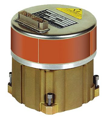
The SPAN CPT7 provides tightly coupled GNSS+INS navigation technology in a rugged, compact unit. Commercially exportable and designed for integration into a wide variety of applications, it delivers assured positioning anywhere. SPAN technology tightly couples GNSS and inertial navigation system (INS) measurements. The system enables continuous, robust positioning and fast reacquisition in challenging navigation environments where GNSS signals may be unreliable or unavailable for short periods. Dual antennas deliver instant alignment. NovAtel’s OEM7 Interference Toolkit (ITK) provides interference detection and mitigation, with the spectrum analysis function allowing integrators to identify interference within the GNSS frequency bands and implement digital filters to eliminate the problem.
The commercial-off-the-shelf (COTS) LN-200C is a compact and lightweight six-degrees-of-freedom inertial measurement unit (IMU) that can be used for instrument stabilization, motion compensation and navigation in commercial, aerospace and industrial applications. Based on fiber-optic gyro (FOG) technology, the LN-200C IMU’s hermetic seal and lack of moving parts help to ensure low noise and extended operational life. The LN-200C can serve as a drop-in replacement for applications that don’t require the full operational range of the original LN-200 and that can benefit from the expedited licensing and global ease of use offered by the LN-200C.
Global Certification Forum (GCF) protocol conformance tests available
Photo: Rohde & Schwarz
The Rohde & Schwarz CMW500 wideband radio communication tester and SMBV100A GNSS simulator have been expanded to support Global Certification Forum (GCF) protocol conformance tests for C-V2X device certification. Utilizing the Qualcomm 9150 C-V2X chipset from Qualcomm Technologies, the R&S CMW500 acting as an LTE network simulator allows automakers to test C-V2X direct communications (PC5) according to GCF Work Item 281. The new R&S CMW-KK550 test package includes the 3GPP Protocol Conformance tests from LTE-V2V GCF Work Item 281 and LTE-V2X GCF Work Item 282. The R&S CMW-KU514 C-V2X software package on the R&S CMW500 is used to verify data transmission and reception over the PC5 interface in ideal, faded and congested channel conditions. Together, both packages enable Rohde & Schwarz to support C-V2X device testing through all protocol layers.
The Multimax FV family is available in a range of configurations, supporting multi-constellation GNSS. The antennas also support up to dual MIMO LTE (including Band 14 for the FirstNet public safety network), 3×3 MIMO Wi-Fi or 2×2 MIMO Wi-Fi. With a small footprint and a strong, bolt-mount aluminum base, the Multimax FV family provides protection against natural hazards threatening vehicles, including vibration, ice, salt, car washes and tree sweeps. The high-gain antennas deliver a large cellular footprint alongside high-rejection GNSS technology (GPS, GLONASS, Galileo and BeiDou).
For Beyond Visual Line-of-Sight (BVLOS) flight operations
Arctic UAV has adopted Kongsberg Geospatial’s IRIS UAS Airspace Awareness application for BVLOS operations within Canada’s Arctic. IRIS provides simultaneous monitoring of multiple drones. It offers real-time calculation of aircraft separation and communications line-of-sight, real-time visualization of track and weather data.
M.A.D.S detects and identifies commercial drones within a 5+ kilometer range, providing GPS positioning of both drone and pilot together with the drone’s speed and heading. Once a drone threat is established, the system enables a 500-meter electronic exclusion zone to be created around the yacht. Should the drone approach this exclusion zone, its control/video signal is blocked, initiating a fail-safe mode and forcing a landing or return to operator.
Operates on the Wave Relay mobile ad hoc network (MANET)
The Auto-Tracking Antenna System is a portable ground-to-air antenna for tracking aircraft, including drones. Defense customers can use it for better airborne communications relay and full-motion video camera/sensor data transmission. It can be assembled and deployed in less than 15 minutes.
Version 6 of Virtual Surveyor drone surveying software offers a faster, more efficient workflow and better user experience in a more stable platform than previous versions. Along with new capabilities is an improved licensing system and an extended free application. The software generates an interactive onscreen environment through orthophotos and digital surface models generated from a UAV, where the surveyor selects survey points and breaklines to define the topography. It enables land surveyors to complement traditional fieldwork with UAV imagery to generate highly accurate topographic products.
Foresights is a risk management and geospatial analytics platform designed to help clients manage forestry assets quickly, effectively and accurately. Foresights identifies areas of new or potential risk, and delivers operations tracking and forest damage management services. It combines satellite imagery, topography maps, soil maps, meteorological data and near real-time ground input from operational teams to deliver optimized insights. It can detect damage as small as 0.1 hectare (0.25 acre) from pests, disease and drought.
EOS Platform provides a powerful toolset for geospatial analysts — offering search, analysis, storing and visualization of large amounts of geospatial data. Image data obtained from LandViewer or uploaded from a user’s computer is stored in cloud-based EOS Storage and is instantly available for remote-sensing analysis or image processing. EOS Processing offers 16 workflows that run online, including raster tools, remote sensing analytics, photogrammetry and proprietary feature extraction algorithms designed by EOS engineers and data scientists to address the main challenges of agriculture, forestry, oil, gas, retail, city planning, defense and other industries.
The Esri book GIS for Surface Water: Using the National Hydrography Dataset by Jeff Simley details how to use geographic information system (GIS) technology to visualize and analyze data sets. Simley is an award-winning cartographer and the former lead of the hydrography program at the United States Geological Survey (USGS). The book examines the complexities of surface water systems and shows readers how to use the Esri ArcGIS software with government water data sets to better study and manage the United States’ vast water system.
EOMAP has opened a commercial online store for global shallow-water bathymetry derived from satellite data. At the store, EOStore Bathymetry, customers can search for and request high-quality data. Satellite-derived bathymetry (SDB) is a valuable tool for the surveying, planning and management of coastal and offshore sites. SDB can provide shallow-water bathymetric data worldwide without the need for a physical presence in the area of interest. EOMAP developed the bathymetry store in response to industry feedback. EOStore Bathymetry offers different horizontal spatial resolutions of the bathymetric grid of 2 to 15 meters, making the data suitable for surveying as well as planning and modeling purposes.
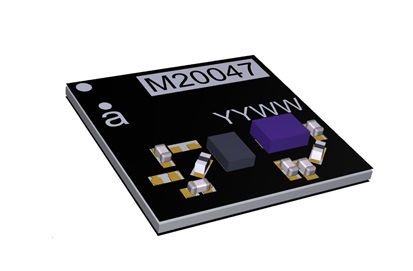
Antenova is shipping its ultra-small GNSS active antenna module for tiny positioning devices, the RADIONOVA M20047-1. The antenna module includes a low noise amplifier (LNA) and surface acoustic wave (SAW) filter for better positioning from difficult locations.
Antenova Ltd. is a manufacturer of antennas and RF antenna modules for connected devices and the internet of things.
The RADIONOVA M20047-1 is designed for small consumer devices such as smartwatches. (Photo: Antenova)
The RADIONOVA M20047-1 is an active antenna module for GNSS applications in the 1559-1609 MHz satellite bands using GPS, GLONASS, Galileo or BeiDou.
The M20047-1 antenna module comprises an SMD antenna with built-in active components: an LNA filter and SAW to boost antenna performance — so designers will not need to add these — contained in a compact FR4 part with low power consumption, measuring 7.0 x 7.0 x 0.9 millimeters and weighing less than 2 grams.
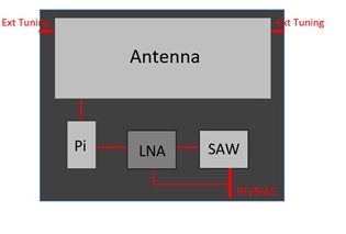
The onboard LNA and SAW filter act to boost the signal to the GNSS processor in environments where there is a restricted view of the sky or where line-of-sight to the horizon is difficult, the company said.
Architecture of the Antenova antenna. (Image: Antenova)
Antenova has also added an external matching feature to compensate for any de-tuning of the antenna caused by proximity to other components, such as a plastic case or a battery.
The clear-out area required by the antenna module is only 7.0 x 5.0 millimeters. This, with its tiny size, makes the M20047-1 suitable for small positioning devices where space on the PCB is tight, such as wearable devices, asset tracking devices, sports cameras and equipment and smartwatches.
The M20047-1 is an alternative to Antenova’s Sinica antenna (part no. SR4G008), which Antenova also recommends for accurate positioning.
The M20047-1 was first announced at the Consumer Electronics Show in Las Vegas in January.
Antenova’s antennas are specifically designed for easy integration. The datasheet and evaluation kit for the M20047-1 are available from www.antenova.com. Antenova also provides full engineering support, antenna testing, tuning and integration for its customers.
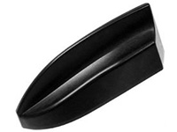
Airgain Inc. has released its Multimax FV 6-in-1 and 5-in-1 antennas.
The compact Multimax FV family is available in a range of configurations, supporting multi-constellation GNSS. The antennas also support up to dual MIMO LTE (including Band 14 for the FirstNet public safety network), 3×3 MIMO Wi-Fi or 2×2 MIMO Wi-Fi.
Airgain is a provider of advanced antenna technologies used to enable high-performance wireless networking across a broad range of devices and markets, including connected home, enterprise, automotive and internet of things.
With a small footprint and a strong, bolt-mount aluminum base, the Multimax FV family provides protection against natural hazards threatening vehicles, including vibration, ice, salt, car washes and tree sweeps.
In addition, the elegant shark-fin design allows fleet owners to add style to their vehicles without compromising performance.
The new products include high-gain antennas that deliver a larger cellular footprint alongside high rejection GNSS technology with coverage for multiple satellite systems including GPS, GLONASS, Galileo and BeiDou.
“Not only does reliable connectivity matter to fleet owners, but also aesthetics and the antenna form factor,” said Reed Pangborn, Airgain’s vice president of Channel Sales for North America. “Our new Multimax FV family is uniquely designed to deliver in each of these key areas. Owners can rely on our commitment to providing class-leading performance across cellular, Wi-Fi and GNSS as well as our industry-best reliability, but all built into a new, sleeker design that complements today’s fleet vehicles.”
The Multimax FV family of antennas can be ordered in either black or white and are available now.
GNSS antenna maker Tallysman has introduced the TW7875 magnetic mount GNSS antenna, which is designed for precision dual-frequency positioning. It is capable of receiving GPS L1/L5, GLONASS G1, BeiDou B1, Galileo E1/E5a and NavIC L5.
The TW7875 employs Tallysman’s Accutenna technology, which provides superior multipath signal rejection due to its low axial ratio across the full bandwidth, the company said.
The antenna also provides a linear phase response and tight phase center variation at a new economical price point, according to the company, which said it provides performance comparable to higher priced dual-band GNSS antenna.
It is designed for precision agriculture, autonomous vehicles and other applications where precision matters.
The TW7875 is housed in a magnetic mount IP67 rated housing. It can also be ordered without the magnet since it can also be mounted by screws or double-sided adhesive tape.
Model TW3875 is the embedded antenna version of the TW7875. It is available with a wide selection of connectors and custom cable lengths, and can be custom tuned by Tallysman to ensure optimum performance within the customer’s enclosure.