Rx Networks TruePoint.io global precise point positioning (PPP) correction service now provides quad-constellation support.
More mobile devices are integrating multi-constellation GNSS chipsets for better positioning. With quad-constellation expanded multi-constellation support, Rx Networks TruePoint.io global precise point positioning (PPP) correction service unlocks that accuracy, providing global PPP corrections for every major GNSS constellation those chips can track.
TruePoint.io global PPP originally delivered GPS and GLONASS corrections. Now, it also provides corrections for Galileo and BeiDou. Mass-market multi-constellation GNSS chipsets can now augment all their satellite measurements with accuracy and fully leverage their positioning capabilities with quad-constellation support.
Consumer devices now have the potential to achieve 50-cm position accuracy when using Rx Networks services for any of the four GNSS constellations. Other internet of things (IoT) and infrastructure applications that do not require real-time positioning can realize 10-cm accuracy in a variety of environments.
Multi-constellation correction capability ushers in new possibilities and use cases for the connected receiver, according to Rx Networks.
TruePoint.io remains ubiquitous and as flexible as possible to GNSS chipsets using industry standard formats, and is also receptive to custom integration services for unique usage scenarios. By offering PPP and other high accuracy services in a variety of data standards, TruePoint.io empowers telecom providers with a straightforward approach to integrating high- accuracy services that provide more value to their client devices, and propels the development of exciting new use cases.
“With this new expansion of TruePoint.io, applications already serviced by Rx Networks can accelerate their market growth objectives with better accuracy and precision using constellations ideal for target regions,” said Vincent Chen, product manager of Truepoint.io. “Being able to deliver global PPP corrections for GPS, GLONASS, Galileo and BeiDou also sets the stage for the addition of more constellations like QZSS. Stay tuned.”
U-blox has released a firmware update for its ZED-F9R positioning module, bringing robust centimeter-level positioning to slow-moving use cases such as robotic lawnmowers, e-scooters and shared bicycles.
Based on the ZED-F9R high-precision sensor-fusion module, the u-blox ZED-F9R-02B was designed for use in autonomous and industrial applications that require simple and efficient implementation and where rapid access to highly accurate positioning data is key, even in challenging signal environments such as dense cities.
The ZED-F9R uses the u-blox F9 multi-band GNSS receiver platform to concurrently track up to four GNSS constellations. Applying real-time kinematic (RTK) techniques, the module can derive positioning data with centimeter-level accuracy.
The high-precision GNSS measurements are fused with data from the module’s inertial measurement unit (IMU), GNSS correction data, odometry information, and a vehicle dynamics model to provide high-quality positioning accuracy in situations where GNSS alone would fail. The receiver includes dynamic models for robotic lawnmowers, e-scooters and automobiles.
The ZED-F9R-02B integrates the u-blox GNSS correction data service, broadcast in the highly scalable state-space representation format, making it easier to deliver fast time-to-market precise positioning solutions.
An autonomous lawn mower trims the grass in a park in Finland. (Photo: Scharfsinn86/iStock/Getty Images Plus/Getty Images)
Robotic lawnmowers achieve further improvements in terms of their positioning accuracy from the module’s ability to calibrate its dead-reckoning system even at low speeds. The module’s highly accurate position output lets end users precisely delimit the mowing area using software rather than with boundary wires, and deploy robotic lawnmowers on complex lawn shapes while excluding trees and shrubs. Users can align each pass of the mower with the next more accurately than before, delivering a professional-looking striped lawn.
According to U-blox, combining these features allows product designers to use the module to create mowing equipment that enables “robotic mowing as a service” capable of operating in complex environments without the upfront cost and commitment of installing boundary wires.
“Our new ZED-F9R-02B high-precision module is a turnkey dead-reckoning solution that will enable designers to bring products that need dead-reckoning technology to market more quickly than if they had to implement it from scratch,” said Alex Ngi, product manager, Industrial Navigation and Robotics, Product Center Positioning at u-blox. “It will also allow companies working in niche markets to employ dead-reckoning technologies without needing to build and maintain expertise in the subject.”
The ZED-F9R-02B offers support for a range of correction services, including the SPARTN format, which will make it straightforward to distribute GNSS correction data over large geographical areas.
iGPSPort cycling computer. In another announcement, U-blox and iGPSPORT, a sports hardware and data service provider operating out of Wuhan, China, have announced the iGS320 cycling computer, which builds on the u-blox M10 positioning platform. The cycling computer leverages the U-blox M10 platform’s ultra-low power consumption, compact size, and its ability to track all four GNSS to offer endurance athletes a superior user experience.
Adopting the U-blox M10 positioning platform in its iGS320 cycling computer brought iGPSPORT an 80 percent increase the power autonomy to deliver 72 hours of continuous tracking, up from 40 hours in their previous solution. Concurrent reception of up to four GNSS constellations increases coverage and accuracy in otherwise challenging signal environments.
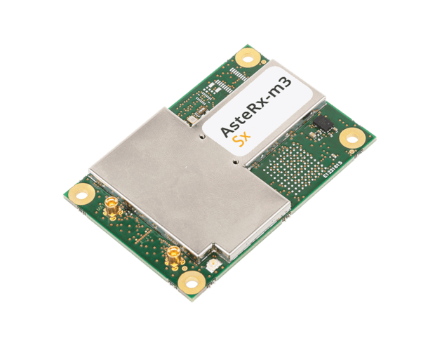
OEM receiver board includes Septentrio’s innovative SECORX-S service, bringing always-on sub-decimeter accuracy, without the need for additional correction subscriptions
Photo: Septentrio
Septentrio has launched the AsteRx-m3 Sx OEM board, a new dual-antenna receiver that combines Septentrio’s latest core GNSS technology with the SECORX-S sub-decimeter correction service to enable convenient plug-and-play positioning.
High-accuracy positioning is available directly out of the box as GNSS corrections are automatically streamed to the receiver. This significantly simplifies the user’s GNSS receiver set-up process and eliminates completely the hassle of corrections service subscription and maintenance.
Corrections are delivered via internet or via L-band satellites ensuring sub-decimeter service even in remote locations where there is no easy internet access.
“With the AsteRx-m3 Sx, we combine our latest GNSS innovations of the AsteRx-m3 family with the convenience of the SECORX-S always-on corrections, all in the same product,” said Danilo Sabbatini, product manager at Septentrio. “This offers higher reliability and operational efficiency to our customers, at an even lower cost.”
With its dual-antenna configuration, AsteRx-m3 Sx offers heading information immediately from power-up, allowing path optimization and fully informed navigation from mission start. Septentrio’s renowned GNSS+ algorithm suite ensures robust and reliable operation in challenging environments even in the presence of RF interference and under heavy vibrations, the company said.
AsteRx-m3 Sx offers PPP-RTK sub-decimeter accuracy with fast convergence time in the U.S. and Europe.
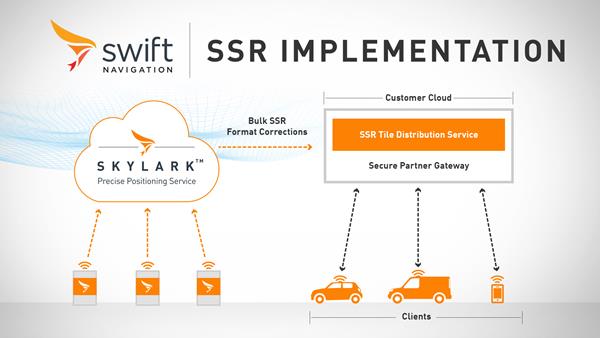
Swift Navigation has launched its production-grade SSR (state space representation) service across Swift’s coverage areas.
Swift is a San Francisco-based tech firm offering GNSS and precise positioning technology for mass-market applications in autonomous vehicles, mobile and internet of things (IoT).
SSR is a bandwidth-efficient format to deliver GNSS corrections to mass-market applications, such as for automotive and mobile customers. It is offered through Swift’s Skylark precise positioning service.
As a new option for corrections delivery available as part of Swift’s precise positioning service, SSR delivers seamless and homogeneous accuracy throughout a coverage area. To date, Skylark delivered corrections in OSR (observation state representation) format for compatibility with legacy equipment but with the introduction of SSR, the power of Swift’s cloud error modeling is now available in its native format.
SSR provides users with fine-grained information about GNSS error sources. SSR divides the coverage region into a series of “tiles” which can be broadcast to all users within that tile, enhancing scalability and minimizing bandwidth while maintaining the utmost security and privacy.
With the capacity to reach millions of connected devices in markets such as mobile and automotive, it is critical to provide both a scalable and secure solution. Swift’s Skylark can deliver bulk corrections data to enterprise customers’ backend for distribution, putting the customer in control of their own users’ privacy and security.
Swift’s enterprise-reference architecture code equips customers with the SSR Tile Distribution Server software that provides a seamless integration path to incorporate SSR corrections into their own cloud or on-premise solution.
Swift’s SSR solution is also based on the open standard from 3GPP. The significance of utilizing the SSR positioning standard from the 3GPP standards body is that it meets the interoperability requirements demanded by mass-market mobile and automotive applications.
“The team at Swift is excited to bring its production-grade, standards-based SSR service to market,” shares Fergus Noble, CTO at Swift Navigation. “The ability to deploy SSR to users in a scalable way, while maintaining privacy, makes it possible for automotive, cellular and IoT mass-market customers to integrate precise positioning into their service offering.”
Skylark is available for integration into wide-area, high-precision positioning applications across the continental United States and Europe and is available in the countries of Japan, South Korea and Australia, with plans to expand globally. Skylark is an ever-expanding service and is scalable to service millions of users. All eligible Skylark subscribers begin with a free trial or pilot program.
New players are offering GNSS correction services — pushing prices down and offering new business models. What opportunities does this open up?
Jules McNeff
“This trend is encouraging, as new entrants bring energy and new ideas, keeping the PNT technology sector fresh. GNSS corrections enhance the value of dynamic mapping coupled with grid-coordinate systems such as the U.S. National Grid in producing user-friendly geolocation values for delivery of people and things and especially enabling efficient, precise, land mobility activities such as spatial awareness for autonomous vehicle movement and command and control of emergency response operations.” — Jules McNeff Overlook Systems Technologies
Greg Turetzky
“In a 5G world where most devices regardless of size are connected, it make sense that those devices that are mobile are going to need to be located. Correction services are key to providing enhanced accuracy, and new business models are needed to address these new markets that are fundamentally different than traditional high-accuracy markets.” — Greg Turetzky Consultant
Jean-Marie Sleewaegen
“Traditional correction services rely on bidirectional communication between a user and a local correction provider. They offer centimeter accuracy over small regions. Instead, new services broadcast corrections applicable to larger areas and with flexible accuracy levels, from centimeters to decimeters. They bring benefits not only in pricing, but also in terms of accessibility, scalability and ease of use. They make accuracy transparent to the user, opening up the opportunity of high accuracy to mass-market and industrial applications.” — Jean-Marie Sleewaegen Septentrio
Septentrio has entered into a commercial agreement with Sapcorda, a global provider of sub-decimeter GNSS corrections.
Through the collaboration with Sapcorda, Septentrio will pioneer an no-hassle corrections integration into a new line of products for the high-accuracy industrial market.
These new products will consist of Sapcorda’s SAPA Premium corrections integrated directly into Septentrio’s latest GNSS receiver technology. The result is sub-decimeter accuracy, which is available to users right out of the box. This significantly simplifies the user’s GNSS receiver set-up process and eliminates the hassle of corrections service subscription and maintenance.
Such GNSS receivers acquire corrections via internet as well as via satellite broadcast and deliver reliable, broadly available sub-decimeter positioning to high-volume industrial applications.
Sapcorda integration program
Sapcorda release its SAPA augmentation service integration program on May 14, following the launch of its SAPA Premium service. The integration program targets companies integrating GNSS chips or receivers and looking to enable their systems to perform in high-accuracy mode.
The program offers step by step service integration and proof of concept guidance for upgrading the integrators’ GNSS systems to deliver down to centimeter-level positioning accuracy.
The program also includes the offering of free service data, used to validate positioning performance on the target application. The program participants also receive commercial support for introducing the correction data on their marketed products.
The SAPA service is delivered using optimized data format and can be integrated by modern or traditional high-accuracy receivers compatible with open standards such as SPARTN and RTCM.
Sapcorda’s SAPA services are designed to bring high-precision GNSS positioning to mass market, as well as general industrial and automotive applications. The correction data stream is optimized for homogeneous performance and end-to-end data security with continental coverage in the United States and Europe.
The service data transmission also provides unmatched low bandwidth consumption, with broadcast transmission via direct IP connection or geostationary satellite signal (L-band).
Sapcorda was established in 2017 to provide an open approach to a safe, broadly available and scalable corrections service. By adding Sapcorda’s SAPA service to its corrections portfolio, Septentrio begins offering sub-decimeter accuracy with quick convergence time anywhere in the U.S. and Europe.
Autonomous vehicles, robots
“This collaboration allows both companies to bring innovative solutions, inspired by the growing market of autonomous vehicles and robots, to the high-accuracy industrial markets,” said Jan van Hees, business development director at Septentrio. “By integrating Sapcorda’s SAPA service into our products, we are completely removing the hassle of managing corrections for the customers. This means faster set-up times and worry-free, always-on high-accuracy positioning throughout the whole receiver lifetime.”
“At Sapcorda our focus is on providing a high-accuracy service suitable for demanding applications where both performance and safety is critical. This includes land robots, UAVs, logistic applications and autonomous vehicles,” said Botho Graf zu Eulenburg, CEO at Sapcorda. “Septentrio’s field-proven high-precision GNSS receivers and their focus on reliability and robustness aligns perfectly with our mission and the capabilities of our SAPA services.”
This broadens the range of Septentrio’s existing GNSS solutions, allowing the company to serve a wide range of customers with various requirements in terms of accuracy, operation location and scalability. Read Septentrio demystifies GNSS corrections for more about GNSS corrections and correction methods such as Sapcorda SAPA (PPP-RTK) service.
This insight column from Septentrio explains the role of GNSS corrections in precise positioning. It explores the three most popular correction methods: RTK, PPP and PPP-RTK.
Let’s say you need reliable accurate global positioning in your technology. You do some research and decide to get yourself a multi-frequency GPS/GNSS receiver. You order an evaluation kit, but how to get your receiver to deliver the high accuracy that it promises?
GNSS receivers rely on external corrections to compensate for GNSS errors to achieve decimeter- or centimeter-level accuracy as fast as possible.
Correcting GNSS errors
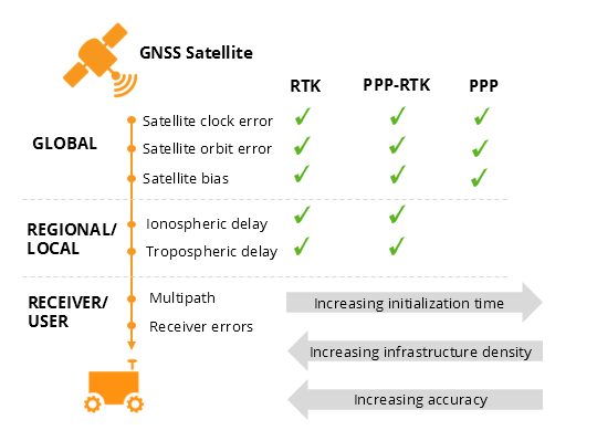
GNSS-based positioning is calculated using a method that, by itself, is limited in accuracy due to several errors caused by GNSS satellites as well as the Earth’s atmosphere.
Even the advanced clocks on board GNSS satellites experience minute drifts that cause clock errors.
The movement of GNSS satellites is predicted as they orbit the Earth. These predictions are not perfect, which results in orbit errors.
Satellite equipment introduces small signal errors, which are modeled as satellite biases.
Atmospheric errors caused by distortions and delays are experienced by the signal as it passes through the Earth’s ionosphere (outer layer) and troposphere (layer near the Earth’s surface).
The local environment around the receiver as well as the receiver itself can introduce errors. For example, satellite signals can be reflected off buildings and tall structures (multipath).
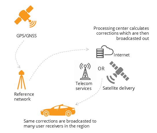
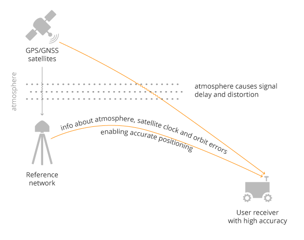
A GNSS receiver cannot correct satellite and atmospheric errors by itself; it relies on data provided by an external source. Clock and orbit errors are satellite-dependent, and so are the same around the world. Atmospheric errors, on the other hand, depend on the path the signal takes as it travels from the satellites to the user, differing depending on the receiver’s location.
To overcome both satellite and atmospheric errors, a reference station (also known as a base station) can be used. A reference station — a GNSS receiver installed at a fixed and precisely known location — estimates GNSS errors and sends them in the form of GNSS corrections to the user receiver. A reference network consists of interconnected reference receivers spread over a geographic area.
A user receiver gets data sent from a GNSS reference station to correct satellite and atmospheric errors. (Image: Septentrio)
Receiver-side errors can only be handled partially, by robust receiver technology and careful operation. Depending on which type of corrections are applied, it can take a few seconds to several minutes of initialization time for high accuracy to be achieved.
Types of corrections for high-accuracy positioning
Until recent years, RTK and PPP have been the established methods of providing GNSS corrections to user receivers. But the demand for high-accuracy positioning is on the rise, paving the way for new positioning techniques such as the hybrid PPP-RTK.
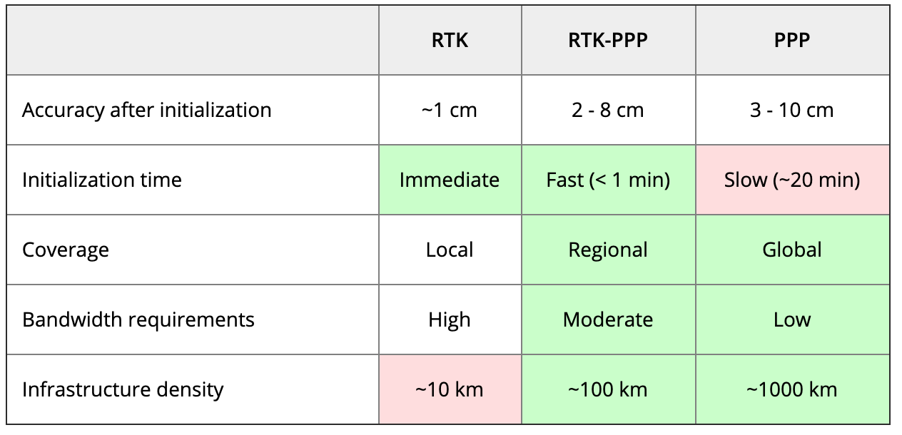
RTK: Highest level of accuracy. With the RTK (real-time kinematic) method, a user receiver gets correction data from a single base station or a local reference network. It then uses this data to eliminate most of the GNSS errors.
RTK is based on the principle that the base station and the user receiver are located close together (a maximum 40 kilometers or 25 miles apart) and therefore “see” the same errors. For example, since the ionospheric delays are similar for both the user and the reference station, they can be cancelled out of the solution, allowing higher accuracy.
While in the RTK method corrections are provided for a specific location, in the PPP and PPP-RTK methods, a correction model is broadcast to a larger area, but with slightly lower accuracy. To transmit this correction model, a message format called SSR (Space State Representation) can be used. There is some confusion in the industry about the term “SSR” since it is often associated with the newer PPP-RTK method. But be careful, since “SSR” is occasionally used as a buzzword to refer to traditional PPP services as well.
PPP: Globally accessible and accurate, but at a cost. Precise point positioning (PPP) corrections contain only the satellite clock and orbit errors. Since these errors are satellite specific, and thus independent of the user’s location, only a limited number of reference stations is needed around the world. Because atmospheric errors are not included in PPP corrections, only a lower accuracy level can be achieved with this method. Also, a longer initialization time is expected of up to 20-30 minutes, which may not be practical for some applications. PPP has been traditionally used in the maritime industry; today it has expanded to various land applications such as agriculture as a convenient way to get global GNSS corrections.
PPP-RTK: Best of both worlds? PPP-RTK (a.k.a. SSR) is the latest generation of GNSS correction services, combining near-RTK accuracy and quick initialization times with the broadcast nature of PPP. A reference network, with stations about every 150 kilometers (100 miles), collects GNSS data and calculates both satellite and atmospheric correction models.
As explained above, atmospheric corrections are regional, and so a denser reference network is needed than for PPP. These corrections are then broadcast to subscribers in the area via internet, satellite or telecom services. Subscribed receivers use the broadcast correction model to deduce their location-specific corrections, resulting in sub-decimeter accuracy.
Comparing the three GNSS correction methods
The table below compares the three correction methods, highlighting their strengths and weaknesses.
Table: Septentrio
The infrastructure density and initialization time for all three methods vary with the different kinds of errors that are corrected. The broadcast nature of PPP-RTK and PPP, as well as the lighter infrastructure that they require, makes these methods scalable for mass-market applications.
Types of errors that are corrected by each of the three methods. (Image: Septentrio)
Some GNSS receivers also incorporate advanced positioning algorithms to compensate for receiver-side issues such as multipath (for example, see Septentrio APME+), jamming and spoofing. This adds reliability and robustness to high-accuracy positioning.
Getting GNSS corrections
Modern industrial receivers often get their GNSS corrections via a subscription service, delivered via internet (using NTRIP protocol), satellite or 4G/5G. Today, there is a boom in the correction-service market driven by high-accuracy demands of the automotive industry, automation and smart consumer devices. Automotive suppliers and many other new players are deploying infrastructure to set up services for centimeter-level positioning around the globe.
User receivers often get their GNSS corrections via a subscription service delivered via internet, satellite or 4G/5G. (Image: Septentrio)
PPP and PPP-RTK corrections can even be transmitted directly by the GNSS satellites, as in the Japanese CLAS service from the QZSS constellation, or in the planned High-Accuracy Service (HAS) from Galileo. Depending on the network density and quality of the error modeling, different initialization times and accuracies can be achieved. This means that positioning quality can vary from one service provider to another.
Major telecom companies such as Deutsche Telekom as well as the Japanese Softbank and NTT are equipping their infrastructure with GNSS receivers to enable new corrections services. 3GPP, which provides specifications for mobile telephony including LTE, 4G and 5G, now covers broadcasting of GNSS satellite corrections in its mobile protocol. Since reference receivers are becoming part of critical infrastructure, such as telecom towers, it is essential that they have a high level of security to protect them from potential jamming or spoofing attacks (for example, Septentrio AIM+ technology).
Which corrections are right for me?
The right correction service for your technology will depend on your location and service area, your accuracy and reliability needs, as well as your budget. Because the corrections market keeps expanding, it is now more important than ever that integrators or GNSS manufacturers assist you in selecting the best correction method for your industrial application.
If you choose a GNSS receiver which does not “lock” you to a certain correction service, you will be free to choose a correction method which is most suitable for your application and its location. Such “non-locking” open-interface receivers also offer customers flexibility to switch to another more beneficial service in the future, as correction methods keep evolving.
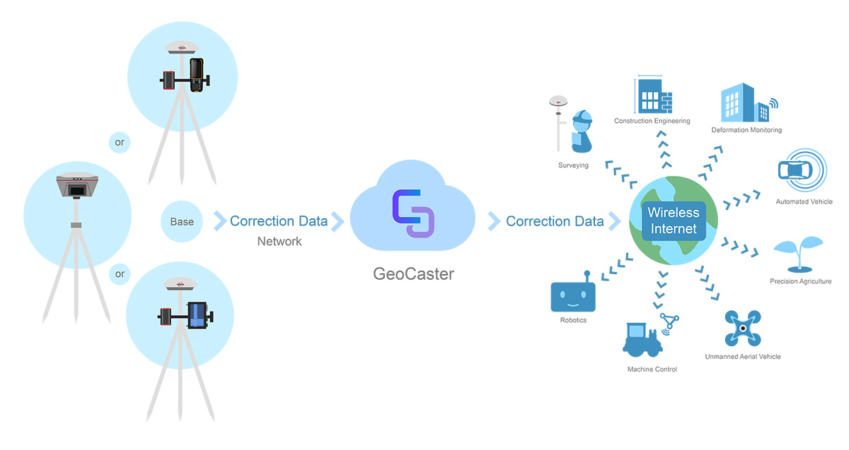
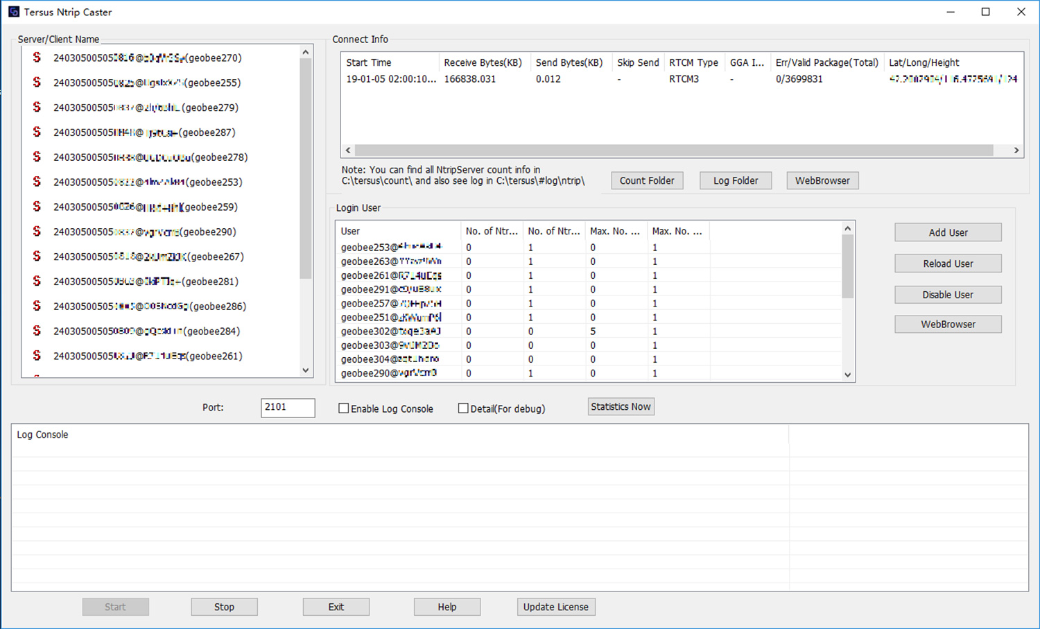
Tersus GNSS Inc. has released the Tersus GeoCaster, a Networked Transport of RTCM via Internet Protocol (NTRIP) caster software. The software expands the company’s product line and provides users with better and more comprehensive services.
The Tersus NTRIP caster software is designed to allow GNSS correction data such as RTCM corrections to be repeated and sent to different end users via the internet.
Screenshot: Tersus GNSS
“GeoCaster has a user-friendly interface, and it not only supports multiple bases online simultaneously but also supports multiple rovers for one base,” said Xiaohua Wen, founder and CEO of Tersus GNSS Inc. “Our users can have a real-time review of detailed statistics and can modify user-defined permissions manually.”
Tersus GeoCaster supports configurable bases online simultaneously and configurable rovers for one base. GeoCaster supports NTRIP protocol and operates continuously.
The software is designed for end users involved in applications such as surveying, construction engineering, deformation monitoring, automated vehicle, precision agriculture, unmanned aerial vehicle, machine control and robotics.
This is the first release of GeoCaster. Version 2.0, targeted at the first quarter of 2019, is expected to offer higher accuracy and longer baseline applications.
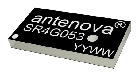
Antenova Ltd. has developed a new positioning antenna that it says can pinpoint a location to within centimeters in the GNSS bands. Antenova is a manufacturer of antennas and RF antenna modules for machine-to-machine and the internet of things.
Antenova will be showing samples of the Raptor antenna at the Consumer Electronics Show, being held Jan. 8-11 in Las Vegas, in booth #2220 in the Westgate hall.
The Raptor antenna utilizes the L2 1200-MHz satellite band that recently became available for civilian use.
The addition of the L2 frequency band combines multi-band satellite signal reception and GNSS correction data. This helps to mitigate position errors, greatly improving accuracy, especially in urban areas, the company said.
As well as improving tracking, the L2 band is beneficial for UAVs, drones, autonomous vehicles, agriculture, grid mapping and other emerging applications, Antenova added.
The antenna is the latest addition to Antenova’s lamiiANT range of rigid FR4 antennas which are designed for easy insertion onto a printed circuit board (PCB).
The antenna itself is very small. It is a GPS single-feed antenna in surface mount (SMD) form, measuring 16.0 x 8.0 x 1.6 millimeters, suitable for small PCBs within all kinds of small electronic devices.
“This is an outstanding antenna, because it achieves the same precision as a much larger, heavier ceramic patch antenna, but in a very compact SMD part,” said Colin Newman, CEO of Antenova. “A ceramic antenna would need to be 35 x 35 millimeters to achieve a similar level of accuracy and performance.” Raptor is supplied in tape and reel for ease in high-volume manufacturing applications.
Septentrio, a high-precision GNSS company, and Sapcorda, a specialist in GNSS correction services, will conduct a live demonstration of a safe, high-accuracy positioning and correction solution for automated driving.
“We are running the demonstration during the course of this week just south of Las Vegas city center,” Neil Vacans told GPS World. Vacans is Septentrio’s vice president of global Sales. The demonstration is taking place in Las Vegas during the Consumer Electronics Show, being held Jan. 8-11.
Sapcorda and Septentrio have put together a solution that is ready for demonstration in Europe and North America.
The companies have combined their respective technologies to deliver the benefits of SSR (space state representation) technology seamlessly to OEM automakers and Tier 1 integrators. These benefits include decimeter-accuracy within seconds, anywhere over an entire continent, to support autonomy levels from lane keeping to full autonomy in a totally homogeneous coverage, the companies said.
The GNSS augmentation service is scalable through simple broadcast corrections, and safety-awareness is provided via Sapcorda’s integrity concept and Septentrio’s integrity monitoring engine.
In December 2018, Septentrio announced its mosaic compact multi-constellation GNSS receiver SiP (system-in-package) module, available in 2019. The Septentrio mosaic, a multi-band, multi-constellation receiver in a low-power surface-mount module with a wide array of interfaces, is designed for mass-market applications like robotics and autonomous systems. The mosaic module integrates the latest GNSS and RF ASIC technology, as well as the robust positioning engine from Septentrio.
All Septentrio GNSS receivers and modules feature AIM+ technology, an advanced on-board interference mitigation commercially available. Septentrio GNSS receivers can suppress the widest variety of interferers, from simple continuous narrowband signals to the most complex wideband and pulsed jammers.
“We are excited to be able to provide live demonstrations of Sapcorda’s safe and precise correction service especially designed for autonomous driving,” said Jan Van Hees, business development director at Septentrio. “Sapcorda provides a unique high-precision GNSS correction service designed for fast, homogeneous accuracy at continental coverage, thus ideal for autonomous and mass market applications.”
“Septentrio specializes in high-precision and high reliability GNSS positioning for a variety of industrial and commercial markets,” said Goran Jedrejčić, business development manager at Sapcorda. “They have developed a range of technologies, including unique jamming robustness and integrity positioning to support safety-sensitive applications in various challenging environments. Combining this with our safety-centered correction service, it is a unique solution for developers of autonomous driving systems.”
“With fast and efficient implementation of Sapcorda SSR-based correction service into Septentrio’s GNSS-platform, we were able to demonstrate the efficiency of the technology for automotive use in a robust & highly efficient way,” confirmed Jedrejčić. “Septentrio offers a unique blend of GNSS-based technologies and is an ideal partner for both traditional and new markets, with growing demand for high-precision positioning.”
SmartNet North America, a high-precision, high-availability network RTK correction service, is assuming operations and incorporating all of the Maine Technical Source (MTS) RTK Network into SmartNet. The merger brings professionals along the East Coast access to a broader coverage area, better geometry and optimized performance.
The MTS RTK Network has two national CORS base stations and 27 base stations covering most of New England. The incorporation of the MTS Network into SmartNet strengthens the network by giving users access to a range of additional tools, including full network quality monitoring and a comprehensive user portal with live status maps and rover management.
The MTS RTK Network has two national CORS base stations and 27 base stations covering most of New England.
Users will also be able to take advantage of immediate enhancements and investments SmartNet is currently making in the New England region. The network will continue to be supported by Maine Technical Source, the authorized sales and support organization for SmartNet solutions on the East Coast.
SmartNet North America is fully open to all makes and models of GNSS equipment and is designed to provide the highest reliability and accuracy 24/7. A variety of different subscription plans are available at the state, regional and national level for any application requiring precision GNSS corrections. The latest expansion brings the total number of SmartNet North America stations to over 1,200 in 40 states and 8 provinces, strengthening SmartNet’s position as the most extensive network coverage of any network service provider on the continent.
“Our commitment to excellence drives us to keep expanding to serve the needs of our customers,†said Wendy Watson, director of reference station operations — GNSS reference networks for SmartNet North America. “Whether it is through enriching our toolsets, adding new stations or incorporating existing networks with the assistance of valuable partners like Maine Technical Source, we will continue to make investments that provide users with the best possible service.”
“The MTS RTK Network was already built on reliable, high-performance Leica Geosystems GPS technology,†said Jim Bosworth of Maine Technical Source. “Now users will have the added benefit of being supported by the industry-leading SmartNet service. The incorporation of the MTS RTK Network into SmartNet is a logical next step in supporting our GPS and GNSS customers in the region.”
Swedish-based survey and GIS equipment maker Satlab Geosolutions is offering a multi-purpose handheld that sends centimeter-level NMEA position data to the user’s tablet or smartphone.
The SLC RTK handheld brings professional high-precision positioning in a new design concept with Bluetooth connectivity for Android, Windows and iOS Bluetooth low-energy (BLE) smart devices, according to the company.
Alternatively, it can be used as a fixed sensor for any compatible NMEA driven positioning application.
The design includes a mounting plate to attach the user’s tablet device so it acts as the SLC’s display. Connectivity also is available via a USB/RS232 port. With a built-in wireless modem and optional remote antenna and pole- or fixed-mount accessories, the SLC can be configured as a sensor for machine control or other mobile applications.
SLC is flexible — it can be paired with data-collection software running on Windows, Android or iOS BLE with compatible applications. Its RTK positioning information can be used in numerous markets including land surveying, high-accuracy GIS, web-based facility management, utilities, pipelines, precise farming, hydrography, geophysics or aeronautics. With 32-GB internal memory, the SLC is also able to record RAW data to be used for post-processed applications.
The SLC has a built-in lithium ion battery and GNSS antenna for up to 12 hours of portable operation. It includes a Telit 3.5G GSM modem for operation as an RTK base or rover, transmitting or receiving corrections from NTRIP networks or via Satlab’s free Internet RTK service. Satlab Internet RTK allows users to stream corrections via IP to any of three Satlab servers around the world; any Satlab rover device can then connect to that same IP connection to receive full GNSS constellation corrections.
“Our new Scandinavian-designed SLC handheld is a different concept, offering RTK centimeter-level positioning at an incredible price in a flexible form factor,” commented Bjorn Agardh, CEO of Satlab. “With our simple SLC Toolbox software utility, users set up the SLC once, and it remains configured every time it’s used.”
The SLC comes in two configurations: as a handheld in a soft case with two tablet/panel mounting plates and a charging USB cable; or bundled with external geodetic antenna, cable and pole mount.