Tag: GNSS Design & Test Newsletter

  • Expanding Our System of Systems

    Putting GNSS into use within much larger aggregates of systems shows the greatest promise yet for earthly good. Goodness knows, we have experienced plenty of benefit from GPS applied over 25+ years, from back-up and fill-in provided by GLONASS, and with further synergy anticipated from Galileo and BeiDou.  But we ain’t seen nothing yet. Two presentations this month at the Geospatial World Forum in Geneva show that teamed with other, non-navigation satellite systems and the ensuing big data sets, GNSS leads the way into 21st-century illuminated knowledge and enlightened action. The European GNSS Agency supports many innovative prototypes to drive Galileo market penetration, and the International Centre for Earth Simulation envisions building a Virtual Earth to better understand the real world.

    Galileo and EGNOS Seek Market Penetration

    Carlo des Dorides, executive director of the European GNSS Agency (GSA), presented experience, results, and a broad call for proposals for future application developers in the “geoSMART + Infrastructure Development” plenary session of the Geospatial World Forum, held May 6–9 in Geneva, Switzerland. The GSA is tasked with market development for the European GNSS programs, EGNOS and Galileo, and its viewpoint is of necessity rosy on user uptake.

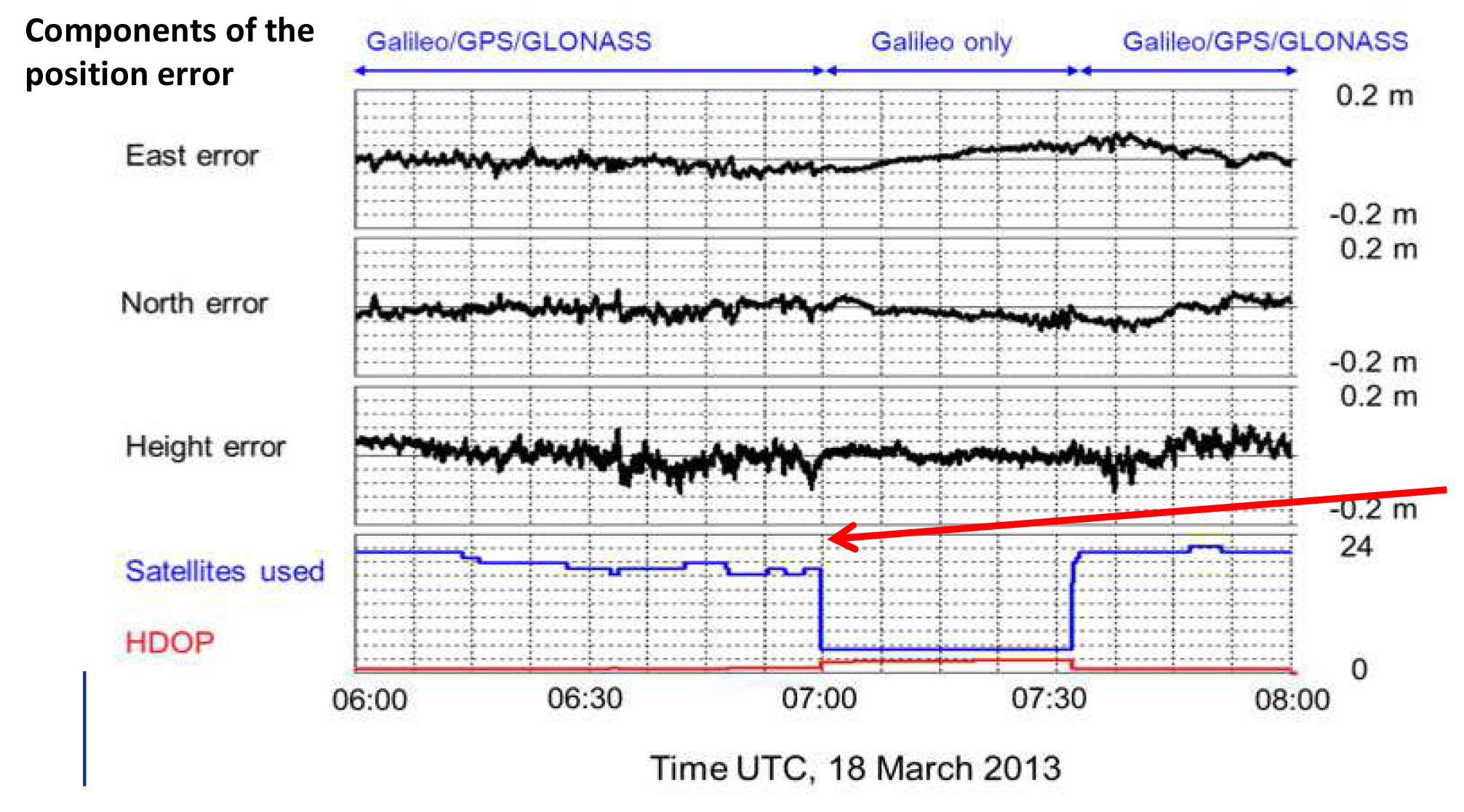
    In a side note before we look at these market-development efforts, des Dorides showed a figure that I had not seen before, one which claims that signal noise from the four orbiting Galileo satellites is noticeably less than that encountered on current GPS and GLONASS combined solutions. Another piece of the portrait we began at the magazine with post-processing PPP using two Galileo GIOVE and two IOV satellites as reported here, and then using four IOV satellites to do differential carrier-phase positioning as reported here.

    Geospatial-world-forum-10
    chart: Galileo GIOVE

    The GSA has funded many small-to-medium enterprise projects, and some of these may actually take off, that is, achieve sustainability through consumer or industry payment. The double edge of stimulus spending such as this is that products may or may not be created, and corresponding business models may or may not be built, with a truly hardened eye towards cash flow. Such a product or service’s only sustainable mode may turn out to be, after all, through government funding. Nevertheless, these are valiant efforts.

    To be fair, the primary goal of these projects is to get Galileo and EGNOS into more widespread use, thus encouraging manufacturers of receivers, smartphones, tablets and so on to include Euro GNSS capability in their products. Establishing self-sustaining downstream enterprises is secondary.

    Emerging from three successive stages of the current framework program for R&D spending, des Dorides cited “10 Patents or registered trademarks,

    33 commercialized products/services, 69 working prototypes, an overall portfolio of roughly 90 R&D projects with a budget of around €70 million.”

    “And more is expected!” he added.

    Among the GSA projects he singled out for further description:

    • SAFEPORT: Safe Port Operations using EGNOS safety-of-life services for vessel traffic management, with a successful prototype demonstration in Dublin port. SAFEPORT has been in the market since January 2013. As commercial-targeted service, or perhaps a government agency (such as a port authority)-targeted one, this may have a return-on-investment prospect.
    • WalkEGNOS, a social web 2.0 mapping solution with a web site following the social network approach, enabling hikers and bikers to share theirs tracks. This produces “new opportunities for high-quality leisure/ touristic services, and value for search and rescue operations.” I am dubious, myself, as to whether hikers or commercial tour services would pay for such services, but it’s certainly worth the effort (and the government money) exploring the possibility through application development. The service is now available; you must register to use (free of charge).
    • GOLDEN-ICE, applying EGNOS GPS corrections to enhance accuracy for precise salt-spreading for road safety. On the market.
    • INCLUSION, a location-based service offering motor-impaired persons, such as those confined to a wheelchair, improved mobility in safe conditions, helping them navigate traffic safety problems and limited accessibility of public transport. On the market.

    Other applications available for use include ASPHALT for high-precision paving, SCUTUM for transportation of dangerous goods, and COSUDEC for surveying of coastal waters. Further programs and results are here.

    The Whole Earth

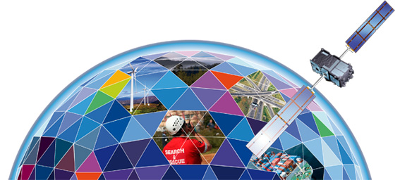
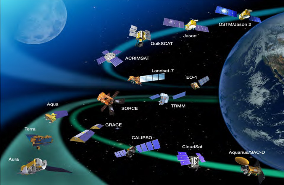
    In easily the most mind-blowing presentation of the conference, founder and president Bob Bishop of the International Centre for Earth Simulation spun a vision of Big Data Earth Science, using the world’s largest computing resources (talk of exoflops and exobytes and “the human mind cannot comprehend these large volumes of data” supplied by many orbiting imagery satellites and other sensor inputs) to model the Whole Earth: surface, subsurface, ocean, atmosphere, and social economics.

    Earth observing satellites are generating big data sets.
    Earth observing satellites are generating big data sets.

    The Centre’s mission is “Helping guide the successful transformation of human society in an era of rapid climate change and frequent natural disasters.”

    In its prospectus, Bishop writes “The key to solving problems in weather, climate and environmental science is high performance computing. Nature can only be accurately described and computed from equations that take account of complex, non-linear interactions between multiple natural systems, i.e. rivers, lakes, oceans, mountains, forests, dust, pollution, cloud cover, snow cover, ice, polar regions, etc. Such equations of motion are so interconnected and intertwined that they can only be managed when all aspects are held in big memory and computed simultaneously. Only then can we begin to address the systemic risks associated with natural disasters and planetary change.”

    The ICES Foundation supports Open Science, which incorporates a combination of open data files, open source code, and open access publications. Much of the data supplied by the following organizations, upon whose resources ICES draws, is either directly produced by or referenced to GPS/GNSS data:

    Global Observing Systems Information Center and the U.S. National Oceanic and Atmospheric; the European Space Agency and Centre for Space Records; the U.S. Geological Survey; the U.S. National Aeronautics and Space Administration; the European Union’s Joint Research Centerthe U.S. National Center for Atmospheric Research; the U.S. Naval Research Laboratory; the European Commission’s Infrastructure for Spatial Information in the European Community (INSPIRE); and many more.

    Slides from Bishop’s Geneva presentation are available here. These however of necessity lack some of the video and Flash Player simulations that he showed at the conference, revealing truly a dynamic planet in all aspects.

    Bishop warned of both sequential and synchronous collapse of natural systems, leading to cascading crises. His language and message bear some resemblance to Al Gore’s An Inconvenient Truth, but Bishop, whose previous 40-year professional career had him responsible for building and operating the international aspects of Silicon Graphics Inc., Apollo Computer Inc., and Digital Equipment Corporation, has assembled some actual practical tools to apply to the many problems.

    The immediate goal is modeling, simulation, visualization, and ultimately understanding of the whole, leading to new forms of civic engagement and insights as to risk, safety, food, water, and energy.


  • Squeeze at the Launchpad for Galileo

    With the first two full-operational-capability (FOC) Galileo satellites successfully through their thermal-vacuum tests, the program’s next hurdle is securing a firm launch date in June aboard a Europeanized Russian Soyuz rocket, operated from Europe’s spaceport on the northeast coast of South America.

    It will not be a walk in the park. Competing with the two Galileo FOC satellites for the same June Soyuz launch are four commercial broadband communications spacecraft owned by O3b Networks of Britain’s Channel Islands, a start-up that promises, if all goes well, to launch as many as 100 satellites.

    O3b and Galileo managers as of late March were rushing to complete final tests to be able to be first to ship their craft to the spaceport and thereby lay claim to priority rights aboard the June Soyuz. Both say they can be on a plane to the Guiana Space Center launch base in April. Should they arrive within days of each other, the already nightmarish dilemma confronting the Arianespace commercial launch consortium will only grow more complicated.

    Here’s the matchup.

    Powerful Backer. O3b, in addition to its plans to launch dozens of satellites if the business model proves out, is backed by SES of Luxembourg, the world’s second-largest satellite fleet operator and as such a big Arianespace customer.

    SES has already shown itself disinclined to maintain its loyalty to the heavy-lift Ariane 5 rocket operated by Arianespace by booking three less-expensive launches, one already completed, aboard the new Falcon 9 rocket operated by SpaceX of the United States. Arianespace can ill-afford to alienate SES, whose 50-satellite fleet requires 3-4 launches per year just to maintain its existing capacity.

    The four first O3b satellites in orbit all have a defect that could cause one or more of them to stop functioning at any time. Without at least four satellites — and preferably six — O3b does not have a business and its future is put into question.

    It would be, to say the least, a public relations calamity for the company if its initial commercial operations, which began in March, were to be suspended in the wake of a satellite failure while waiting for a second batch of four spacecraft. This explains the extraordinary pressure that SES is placing on Arianespace on behalf of a June Soyuz launch for O3b.

    Does it really matter, O3b backers say, if Galileo waits until the next Soyuz launch slot, tentatively set for August?

    Emphatic Politician. It matters to the European Commission, which owns Galileo. Commission Vice President Antonio Tajani has all but pounded the table, insisting that the European Space Agency, hired to oversee Galileo’s technical development, ensure three Galileo launches on Soyuz rockets in 2014.

    Four initial-operating-capability Galileo satellites are in orbit. Indications are that their performance exceeds specifications. Three Soyuz launches carrying two satellites at a time would bring the constellation to 10 spacecraft, enough to offer initial commercial services, according to the Commission.

    Tajani has made clear how much he wants that feather in his cap as he prepares to leave the EC this year, probably headed for a political career in Italy. Make no mistake: as is the case with many wounded animals, Tajani’s status as a lame duck has made him all the more fierce in his insistence that Galileo meet its three-launch schedule in 2014.

    Tajani has put very public pressure on the European Space Agency, which in turn is pressuring Arianespace, for Galileo launches.

    Ariane’s Quandary. Arianespace is already facing an exceptionally crowded launch manifest in 2014 as it coordinates the schedules of three vehicles: the small Vega rocket in addition to the medium-lift Soyuz and the heavy-lift Ariane 5. Because both O3b and Galileo are late, neither has an obvious claim of priority status at Arianespace, which is clearly hoping that the problem will solve itself when either O3b or Galileo arrives at least several weeks ahead of the other.

    At press time, the next Soyuz launch was scheduled for April 3, carrying a European Commission environment-monitoring satellite. Commission officials will attend the launch and no doubt use the occasion to press their case for Galileo.

    There is no telling how this will turn out. Satellites have been known to face last-minute problems even after arrival at the spaceport. This happened to O3b in 2013, as the in-orbit defect did not surface until just before its scheduled Soyuz launch.

    But if one were to hazard a guess, here is the most likely scenario: O3b arrives ready for launch several weeks ahead of Galileo and secures the June launch. Galileo moves to August and is promised a second launch in the autumn. O3b’s planned second launch in 2014 is moved to early 2015, as is the planned third launch of Galileo.

    The effect of these schedule slips on the cost of the Galileo program, which is about a year late — cost overruns that Tajani has vowed will not be paid by the Commission — is a subject for another day.

  • GPS CNAV Debate, and GNSS Interoperability Moves Forward

    The opening plenary session of the Munich Satellite Navigation Summit is convening as this column goes to the electronic press for distribution. Coverage of these top-level system briefings before a select international GNSS audience in Munich will appear in two e-newsletters next week, The European GNSS and Earth Observation Report (EAGER), and in a shortened form via the Navigate! Weekly.

    If you do not already receive these email newsletters, subscriptions to both are free at env-gpsworld-integration.kinsta.cloud/subscribe.

    Until then, here’s an update on the CNAV debate in the United States and wider system-operator background from two recent meetings.

    CNAV So Far.  In the closing hours of 2013, a departing U.S. Cabinet under-secretary for Transportation dropped a verbal bomb on the Pentagon, in the form of a communiqué expressing concern about reliability of the new civil navigation message (CNAV) signal scheduled to emanate in April from select GPS satellites on orbit. Subsequent explosions were detected in halls from Washington to Colorado and Los Angeles.

    The Department of Transportation issued a call for back-up in the form of public comment via the Federal Register. That comment period closes on April 4.

    Meanwhile, one semi-public organization communicated to its members that it finds nothing disturbing about the plan, set to take effect sometime in the coming month.

    IGS Steps Forth on CNAV.  The International GNSS Service, a voluntary federation of more than 200 worldwide agencies that pool resources and permanent GPS and GLONASS station data to generate precise GPS and GLONASS products, issued a statement to its members and participating institutions in March. “We are confident that the IGS network is not at risk due to this change, and it is a welcomed step towards GPS modernization.”

    The communiqué from the Infrastructure Committee went on to say that “This event is considered innocuous to the stability of the receiver network since during a limited GPS CNAV test campaign in June 2013 the IGS network was not affected, only a very specific receiver problem was detected by the IGS Multi-GNSS Experiment, which was informed to the GPS ground segment and addressed.

    “Most modern receivers can track L2C and L5 and the CNAV messages, but the decoded messages should not be used by the receivers. The traditional L1 NAV messages (LNAV) will continue to be transmitted as usual and thus the receiver navigation files, birds, etc., will continue unaffected. Older receivers will be completely unaffected as they do not track L2C or L5.

    “In any case IGS Station Operators and Station Network Managers are advised to keep an eye on receivers and on their data outputs during the start of the CNAV activation. Just in case something strange is observed please stop data submission and notify the IGS (Network Coordinator, Infrastructure Committee) so that we may investigate the issues quickly. In case of doubt with your own equipment please contact the receiver manufacturer and inform the IGS.”

    PNT Advisory Board Airing. Prior to the appearance of the CNAV letter from the departing deputy secretary, the U.S. PNT Advisory Board heard a report in early December from Air Force Space Command on said implementation plan for the GPS CNAV message on L2C and L5. The minutes of that meeting were recently released.

    The minutes relay the gist of General Whelan’s CNAV remarks as: “CNAV has been under discussion for a considerable time. Currently, L2C and L5 signals are being transmitted, but without a navigation message. AFSPC is working hard to activate these messages as soon as possible. One of the reasons for the delay is that additional time was needed to complete testing prior to activation. Testing began in late summer 2013 and, based on initial test results, a way ahead has been plotted. . . . Current plans are to begin initial broadcasting in the spring of 2014. CNAV uploads will occur twice weekly. The signal will meet GPS Standard Positioning System (SPS) standards, but may not achieve current accuracy levels until full implementation in late 2014.

    “CNAV live-sky testing occurred in June [2013] and was conducted in cooperation with civil, industry, and international partners. The two-week test series included independent assessment and verification. The tests identified four errors that required action. The first, which was addressed in real time, related to implementation of the test series. The second required improvement to the tools suite, which should be totally integrated into the ground segment by December 2014. The third and fourth errors required patches to satellite software. All four issues are now regarded as closed.”

    A subsequent presentation to the PNT Advisory Board from a Department of Transportation spokesperson did not directly mention CNAV, according to the meeting minutes, but did include this reminder on civil signal monitoring:

    “DOT is responsible for performance monitoring of GPS civil signals. The International Committee on GNSS’s (ICG’s) transparency principle states that ‘Every GNSS provider should publish documentation that describes the signal and system information, the policies of provision, and the minimum levels of performance offered for its open service.’ Currently, this is only done on GPS L1 C/A signals. Performance standards for L2C and L5 have not yet been established. The crucial function of signal/service monitoring is to verify that commitments to GNSS performance are being met. Additionally, monitoring improves the situational awareness for GNSS operators, and provides assurance that any civil service failure is detected and resolved promptly.”

    Other Global Developments. The International Committee on GNSS (ICG) held a meeting of its Working Group A on Compatibility and Interoperability, in November 2013 in Dubai, United Arab Emirates. A brief summary of those proceedings is now available.

    The notes evidence steady, deliberate organizational and international progress on collaboration between system providers of GNSS signals.

    Among new presentations to the body came several from Russia. Viktor Kashenko, Russian Federation, presented on the “Prospects for Status and Development of GLONASS System Space Complex,” an update on the GLONASS space segment noting that there is a full constellation of GLONASS-M satellites. CDMA signals at L1 and L2 are expected to be available beginning around 2016 or 2017.

    Grigory Stupak, Russian Federation, followed with a presentation titled “SDCM Present Status and Future GLONASS Signals Development.” There are currently 22 SDCM ground stations around the world with a goal of creating seamless coverage throughout Russia with LPV-200 capability. The U.S. asked a question about whether SDCM provides corrections for other constellations in addition to GLONASS. The Russian Federation explained that SDCM currently augments both GLONASS and GPS, but additional constellations could be added in the future.

    Oleg Denissenko, Russian Federation, discussed the goals of the GNSS Monitoring and Assessment System being developed in Russia and identified a list of parameters to be monitored by the international systems.

    Xurong Dong from China gave the status of the International GNSS Monitoring & Assessment Service for OS (iGMAS). Initial operational capability (IOC) is expected in June 2014.  Ten tracking stations have been installed so far, and 25 additional stations are expected to be added in the future. A signal quality monitoring station has also been established in China and a new 40-meter antenna is expected to be installed in 2014.

    Jeffrey Auerbach from the U.S. State Department presented on outcomes of the second Interference Detection and Mitigation (IDM) April 2013 workshop. The European Union noted that they are conducting a survey of professional users in Europe about privacy concerns, and perceptions and understandings of interference and jamming.

    Stanislav Kizima, Russian Federation, provided an overview of the International IDM system concept and recommended the creation of an IDM system database server to be used for monitoring GNSS facilities. He suggested identifying formalized data exchange formats for IDM. A question was asked about whether something like this already exists in Russia. Kizima responded that Russia does have an active system  for  monitoring interference, but not  specifically for GNSS. There are some issues with the existing system because GNSS is not listed as source of interference and the technical facilities are not able to analyze parameters specific to GNSS. Hence the need for development of specific GNSS monitoring facilities. Tom Stansell from the U.S. responded that cell phones could be enabled to become individual detectors of GNSS interference, and the interference source location could be determined this way. This technique is known as crowdsourcing. Kizima noted that cell phones give information on signal power, but not measurement equipment.

    China continued the session on spectrum protection with a presentation by Weimin Zhen on a proposal to develop a template for GNSS interference detection and reporting. He suggested that a generic template specific to reporting GNSS interference be developed.

    Upcoming principal WG-A related meetings:

    • WG-A Inter-session Meeting, Geneva, Switzerland, possible dates July 16-18, 2014)
    • ICG-9, Prague, November 10-14, 2014.
  • Europe’s Spring Season for GNSS

    Europe’s Spring Season for GNSS

    EUResidencePermit-WThe hounds of spring are on winter’s traces. As Galileo emerges from its long, cold slumber, the energy of a new constellation radiates through the skies to encourage blossoms across Europe. ESA’s recent declaration of in-orbit validation means the downstream satnav market can now truly get going.

    If a lot of demand has yet to be demonstrated, certainly a lot of pioneer applications have been developed, and the pent-up current is about to flow. Witness a plethora of GNSS and geospatial conferences in March, April, May, and June, from Munich to Rotterdam to Geneva to London, and on to Prague. The presentations at these gatherings no longer lean so heavily on academic and technical projections and predictions, but embody real-world applications and actual products. Long awaited, Europe’s GNSS spring has finally sprung.

    Brad Parkinson, the chief and original architect of GPS, fittingly kicked off the season this month in London, where he told a UK conference that GNSS needs to be made more robust to ensure worldwide availability of services to users. His concerns over signal availability relate to threats such as the loss of authorized frequency spectrum (implicitly creating licensed jammers), space weather due to hyperactive ionospheric conditions, and deliberate or inadvertent jamming of GNSS signals. Parkinson made his remarks as the keynote speech at GNSS Vulnerabilities and Resilient PNT 2014, hosted by the Royal Institute of Navigation.

    Coming up soon, Dr. Parkinson will also deliver the keynote address for the European Navigation Conference on April 15 in the Netherlands — but more on that anon.

    Munich Satellite Navigation Summit, Munich, March 25–27

    The scene now shifts southward to Bavaria, where the long-running Munich Summit gathers government, financial, industrial, and scientific dignitaries for high-level perspective on all GNSS, certainly with a Galileo emphasis but prominently featuring GPS, GLONASS, BeiDou, QZSS, IRNSS, and SBAS.

    The technical program of the Munich Satellite Navigation Summit includes a multitude of panel discussions involving invited speakers on further topics such as the legal issues of privacy devices and GNSS re-transmitters, achieving precise point positioning (PPP) on a global scale, the role of other autonomous sensors in future navigation, monitoring of climate and natural disasters, and integrated applications of GNSS and Earth observation.

    The summit will also officially open the European Satellite Navigation and provide a parallel track on Copernicus, the European Commission´s Earth observation program.

    GPS World’s contributing editor Tony Murfin will file a complete report on the Munich Summit in the inaugural issue of EAGER, the European GNSS and Earth Observation Report. Subscriptions are free to this new quarterly email newsletter at the preceding link.

    EAGER will feature news of European industry, agency, and scientific developments in satellite-based positioning, navigation, and timing; geospatial technology; Earth observation from space; digital mapping; and location-based services. EAGER focuses on the EU programs Galileo, EGNOS, and Copernicus along with their applications, but also encompasses European involvement in the other GNSSs and their geospatial applications of all kinds. Knowledgeable reporting from European sources, and interviews with and articles by European GNSS/geospatial community leaders. The latest technologies, launch schedules, applications, equipment, and industry and policy developments.

    ENC GNSS 2014, Rotterdam, April 14–17

    More than 120 technical papers will be presented at the European Navigation Conference (ENC 2014), under the thematic header Technology, Innovation, Business. As previously mentioned, Bradford Parkinson will deliver one of the two keynotes on “Assured PNT – Assured World Economic Benefits,” joined on the podium by Prof. Erik Theunissen of Delft Technical University, speaking on “So You Think You Are Safe.”

    The program continues with a Galileo session, in which ESA will present the latest results of Galileo IOV and future plans for FOC.

    Preliminary meetings will be held by the European Maritime Radionavigation Forum (EMRF), the Resilient PNT Forum, EUGIN, IAIN, and European Journal of Navigation. On Tuesday, another kick-off (!!) of the European Satellite Navigation Competition (ESNC) 2014 will take place.

    The Netherlands Institute of Navigation’s organizing committee chair Jac Spaans (also a long-time Editorial Advisory Board member of this magazine, and furthermore a knight in the Order of Orange-Nassau) is pleased to invite all satnav enthusiasts to the conference, taking place the week before Easter, allowing you to extend your stay and enjoy the tulip fields, the windmills, and other objects of interest in The Netherlands. Host-city Rotterdam, one of the biggest ports in the world, gives proof the Dutch saying, “In Rotterdam they do not sell shirts with long sleeves, because they roll them up anyway.”

    Another of GPS World’s contributing editors, Don Jewell, will attend and report on the conference, either in his Defense PNT newsletter in May or as a guest columnist in this GNSS Design & Test newsletter of that month. To be sure, his column will also appear prominently in the second (June) issue of EAGER, the European GNSS and Earth Observation Report. Subscriptions are free to this new quarterly email newsletter at the preceding link.

    Geospatial World Forum, Geneva, May 5–9

    Geo-World-ForumNow in its sixth edition, the Geospatial World Forum concentrates on geographic information systems (GIS) in mapping, remote sensing, satellite navigation as applied to the electricity sector and energy distribution; architecture, engineering, and construction; sustainable agricultural industrialization; smart cities, municipal management; disaster preparedness and coping, natural hazard monitoring; big data as a competitive business asset, business intelligence, and market analysis; multi-sensor integration for monitoring; geospatial’s role in healthcare; global peace and prosperity; and last but by no means least, in fact probably the most important in our long term, climate change.

    If I’m lucky, I’ll make it there myself. Did I mention that coverage will surely feature in EAGER, the European GNSS and Earth Observation Report? Subscriptions are free!

    GEO Business 2014, London, May 28–29

    Next up on our busy travel schedule — and nothing says an industry is growing like the launch of another new conference — comes GEO Business, primarily an exhibition but also conference featuring industrial training and demonstrations featuring the technology and services used by those working with spatial data.

    GEO Business boasts that it was born out of consultation with key industry leaders, and as a result the show is organized in collaboration with the Chartered Institution of Civil Engineering Surveyors (ICES), the Royal Institution of Chartered Surveyors (RICS), The Survey Association (TSA), and the Association for Geographic Information (AGI). This is a joint cooperative event involving major players, both organizational and industrial, in the geospatial community.

    Presentations will be given by Leica Geosystems (Mobile GIS), Esri UK, Carlson Software, Fugro (Advanced airborne survey), Trimble, GeoPlace (spatial addressing), Altus Positioning Systems (single- and dual-frequency data collection), Topcon (global-scope monitoring), Spectra Precision, Ordnance Survey (geospatial data management), iXBlue, and others.

    GPS World publisher Steve Copley will attend, and you can bet I will lean on him for reportage in the June issue of EAGER, the European GNSS and Earth Observation Report.

    By this point, I should start charging a subscription fee to anyone who has failed to sign up for EAGER.

    European Space Solutions 2014, Prague, June 11–13

    EuropeanSpaceSolutions
    photo: European Space Solutions

    Finally, the European Space Solutions conference in Prague has yet to be formally announced by the European GNSS Agency, but a pre-registration page is open.

    The 2013 generation of this conference featured sessions on indoor location-based services and solutions, environmental protection, emergency response and disaster management, mobile applications, sustainable energy, road and traffic management, and the future of the Galileo Public Regulated Service, an encrypted navigation service designed to be more resistant to jamming, involuntary interference and spoofing, designated for authorized users.

    Tim Reynolds, GPS World’s newest contributing editor, will likely report from Prague on this, as he will from several of the earlier spring shows. Based in Brussels for the last decade-plus, Tim will provide in-depth and up-close perspective on Galileo, Copernicus, and all things Europe connected with space and satellite navigation. His main public forum will be EAGER, the European GNSS and Earth Observation Report, but he will also furnish regular stories for the Navigate! e-newsletter and this one.

    Turn on and tune in!

    For winter’s rains and ruins are over,

    And all the season of snows and sins;

    The days dividing lover and lover,

    The light that loses, the night that wins;

    And time remember’d is grief forgotten,

    And frosts are slain and flowers begotten,

    And in green underwood and cover

    Blossom by blossom the spring begins.

     Algernon Charles Swinburne, 1837–1909

  • Who Carries the Gold Standard Now?

    Who Carries the Gold Standard Now?

    China’s BeiDou system claimed a user range error (URE) of 2.5 meters zero age of data (ZAOD) 95% recently.  The parallel GPS specifications commit to 6 meters 95% ZAOD and 7.8 meters 95% all AODs.  Does this mean that BeiDou is more accurate than GPS? Not so fast.

    In late December, director Ran Chengqi of China’s Satellite Navigation System Management Office announced the BeiDou Navigation Satellite System (BDS) Public (or Open) Service Performance Standard. The document details the public service performance parameters of the BeiDou system, including service area, accuracy, integrity, continuity, and availability. It is a basic commitment to customers from BDS providers, but also an important basis for customers to choose, use, and evaluate the system performance.

    A few important qualifications of BeiDou’s performance standard first:

    According to the foreword of the document, “This document specifies the BDS open service performance standard at the current stage.” This is as it should be.

    A paragraph on service volume, however, highlights the fact that BeiDou is as yet a regional service.

    “4.4 BDS OS Service Volume

    The BDS OS service volume is defined as the OS SIS coverage of the BDS satellites where both the BDS OS horizontal and vertical position accuracy are better than 10 meters (probability of 95%). At the current stage, the BDS regional service capability has been achieved, which can provide continuous OS to the area as shown in Figure 2 & Figure 3, including the most part of the region from 55°S to 55°N, 70°E to150°E.”

    The BDS Service Area.
    The BDS Service Area.

    This means that BeiDou commits to 2.5 meter accuracy in China, as well as neighboring countries — and importantly, trading partners — in Southeast Asia plus Australia.

    Does this mean that once BeiDou attains global status, it will provide 2.5 meter accuracy everywhere, on its basic single frequency, open service?  Hard to tell.  Much of its strength, its core strength, one might say, comes from 5 geostationary Earth orbit (GEO) satellites and 5 Inclined Geosynchronous Satellite Orbit (IGSO) satellites. The GEOs  hover over the Equator more or less permanently, south of but in the general longitude of  China’s sovereign national territory. The IGSOs move back and forth from the northern to the southern hemispheres in the same area.

    When BeiDou achieves its planned global reach, an event scheduled for 2020, the constellation will consist of 35 satellites: 5 GEOs, stationed at longitudes so their footprints cover China,  27 medium Earth orbit (MEO) satellites encircling the globe in continuous paths as do those of GPS, and 3 IGSOs over the East and Southeast Asian regions.

    Will globally available accuracy at that point match what is achievable in China?  It takes a better geometric mind than mine to fathom this.

    Even disregarding the geographic limit of the 2.5-meter claim, and ignoring for the moment the mathematical conundrum outlined above, there are reasons to scrutinize the BeiDou Performance Standard more closely, as John Lavrakas of Advanced Research Corporation has done.  His notes, and an illuminating table, follow below after a bit more introduction and background on the general topic.

    The publishing of the Public Service Performance Standard, a common practice among GNSS operators, is also a prerequisite for BeiDou system involvement in international civil aviation, international maritime, 3rd Generation Mobile [phone] System, and other international standard-setting organization activities.

    The document has Chinese and English versions. Because document download from the BDS government website can be difficult, Richard Langley has made them available at the University of New Brunswick website:

    http://www2.unb.ca/gge/Resources/beidou_open_service_performance_standard_ver1.0.pdf

    http://www2.unb.ca/gge/Resources/beidou_icd_english_ver2.0.pdf

    Analysis

    John Lavrakas of Advanced Research Corporation posted the following comment to the an earlier online article announcing the Performance Standard document.

    “I took a quick look at comparing the BeiDou Open Service Performance Standard with the GPS Standard Positioning Service Performance Standard and obtained mixed results.”

    Table 1. Coded to show green for the GNSS service committing to a more stringent standard over the other. Courtesy of Advanced Research Corporation.
    Table 1. Coded to show green for the GNSS service committing to a more stringent standard over the other. Courtesy of Advanced Research Corporation.

    “In some cases, the commitments from BeiDou were stronger (URE accuracy, vertical position), and in other cases the commitments from GPS were stronger (continuity of service, advance notice of outages).

    “The good news is that GNSS systems are documenting the service levels that users can expect. What we will need next is monitoring to verify these service levels are being met.

    “Here is a link to my quick look:

    http://oregonarc.com/2014/01/beidou-performance-standard-how-good-is-it/.”

    Thank you, John.

    A final note.  As the GPS stewards from the U.S. Air Force carefully and proudly remind us at each GNSS conference where they deliver a briefing, actual GPS performance has almost always bettered its specs over the last decade or two — often by a considerable margin.

    And with that, I think we may all return to our various pursuits, secure in the knowledge that while the gold standard may — repeat, may — at times pass in limited special circumstances or under particular conditions, from system to system, overall GNSS Things Are Getting Better All the Time.


  • New GLONASS Navigation Message Proposed

    Russian scientists and engineers are at work on a new code-division multiple-access signal format to be broadcast on a new GLONASS L3 signal. Taking an approach similar to that implemented on the newly designed GPS L5 signal, this will, once implemented across the constellation by new satellite launches, facilitate interoperability with and even eventually interchangeability among other GNSS signals, including of course GPS.

    An article in the November issue of GPS World, authored by Alexander Povalyaev, the deputy head of division in JSC Russian Space Systems and a professor at the Moscow Aviation Institute, will give an outline and provide some details on a new flexible navigation message format proposed for use in the GLONASS CDMA signal under development. The format allows for relatively easy upgrades in the navigation message, if required.

    Navigation messages developed and broadcast so far, by both GPS and GLONASS, are  fixed, regular structures including pages (frames), subframes (rows), and words. Despite their simplicity, “such structures  are very conservative  indeed,” says Professor Povalyaev. The only possibility to update such navigation messages is restricted to the use of previously allocated backup frames. Increasing numbers of such frames make for ineffective use of navigation message transmission capacity. Conversely, the relatively small number of backup frames restricts the potential for future  navigation message upgrades.

    Prof. Povalyaev states that a comparison of data transmission via GLONASS and GPS, respectively, reveals that the data transmission rate in GLONASS is 5 times greater than in GPS. This explained by the higher redundancy of the GPS navigation message. In addition to approximately 11 percent of its subframes in backup, the GPS signal reserves fields for transmission of 32 satellite almanacs. As a result, Povalyaev believes that the GPS navigation-message transmission channel used inefficiently.

    For GLONASS, the situation is different, with fewer backup bits in the navigation message, and fields reserved for transmission of only 24 satellite almanacs. This increases transmission channel efficiency but creates problems when it comes to updating the system, particularly in maintaining backward compatibility for previously manufactured user equipment. From this point of view, he says, a large number if backup frames in preferable.

    He proposes a GLONASS navigation message with flexible row structure, as was used for the first time in the design of the GPS L5 signal. In this structure, the navigation message is formed as a variable row flow of different types. Each row type has a unique structure and contains specified information type, for example, ephemeris, almanacs of specific satellites, parameters of Earth pole movement models, parameters of    ionospheric delay models, and so on. He goes on to describe how signal-processing disruptions in legacy user equipment can be avoided.

    A flexible row structure of the navigation provides more effective use of transmission channel capacity. The main advantage of the flexible row structure is the possibility of its evolutional upgrade, meeting the requirements of backward compatibility.

    Currently GLONASS uses signals with frequency separation in L1 (1592.9 – 1610 MHz) and L2 (1237.8 – 1256.8  MHz).  The foreseen upgrade, already underway with one recently launched GLONASS satellite transmitting an L3 signal, will permit, in the long term, signals with code separation in L1, L2, and L3 (1190.35 – 1212.23 MHz).

    Look for further details in the November issue of GPS World magazine.


  • Looking High in the Sky from Down Under

    A few months ago I wrote in the magazine’s Out in Front column about the surprising abundance of BeiDou-centric papers to be presented at the upcoming ION GNSS+ conference, to which I very much look forward — both the abundance and the conference as a whole. With GLONASS encountering stormy weather of late, and Galileo plugging steadily along but not quite making up time, it seems increasingly possibly that the first GNSS of choice may constitute GPS+BeiDou, if certain spectrum questions can be worked out. News of an advance in Australia further heralds this likelihood.

    Researchers at Curtin University in Perth, Western Australia, have put forth a method integrating GPS and BeiDou signals, in an effort particularly aimed at urban canyons. In Australia at least, the visibility of BeiDou’s five geostationary and five inclined geosynchronous orbit satellites hovering above the Asia-Pacific region can bring added punch to any receiver experiencing skyviews obscured by skyscrapers. The same problem occurs in open-pit mines, said Curtin University professor Peter Teunissen. Open-pit mines are a very big thing in Australia.

    For those surprised to find this flying Dutchman, the inventor of the LAMBDA method for GNSS carrier phase ambiguity resolution, popping up in Australia, it appears he has a secondary appointment at Curtin University.  He remains based, as he has for 20 years, at the Delft University of Technology in the Netherlands, where he is head of the Department of Earth Observation and Space Systems.

    I wish I had a secondary appointment somewhere.

    “By combining GPS with Beidou,” announced Teunissen and colleagues at the Cooperative Research Centre for Spatial Information, “we are making use of Beidou’s 14 new satellites that cross our sky at a high angle, increasing satellite availability, improving positioning capability and ultimately creating a system that is perfect for both urban and mining environments.”

    Beidou of course has a ways to go to achieve its fullness at 35, perhaps as soon as 2020. Combining all and sundry GNSS, more than 100 GNSS satellites are expected to be operational by 2016, so algorithms making use of multiple signals and systems have moved to the fore. As we well know.

    “The emergence of new GNSSs, together with the linking of different systems, has enormous potential for improving the accuracy, integrity and efficiency of positioning worldwide, enabling much more reliable data,” Teunissen added.

    Precise positioning services could boost Australia’s gross domestic product by $13.7 billion by 2020, according to a recent report by a consultant for the Department of Industry, Innovation, Climate Change, Science, Research and Tertiary Education. (Maybe that’s where I should seek my secondary appointment; they’ve got a lot on their plate.)

    In January of this year, Teunissen’s Curtin University group and Dr Dennis Odijk, from the Western Australian School of Mines (WASM), also announced a methodology integrating GPS with Galileo signals. Both projects were funded by the Australian Space Research Program.


  • Get Back, Loretta: DARPA Seeks to Eliminate GPS Dependence

    Get Back, Loretta: DARPA Seeks to Eliminate GPS Dependence

    By Alan Cameron

    Call it irony, poetic justice, or just the nature of the beast. The same impulse that led to the invention of GPS now has engendered a drive to beget non-GPS.

    In the 1970s, the U.S. military began putting together a program “to drop five bombs in the same hole.” The program office, to the wall of which that mission statement was tacked, went on to develop the first satellite navigation positioning system: GPS. In 2012, the U.S. Defense Advanced Research Projects Agency (DARPA) declared that this system no longer sufficed for reliable delivery of precision munitions under every circumstance.

    “More than 98 percent of the missiles currently in the U.S. arsenal have mission durations of less than 20 minutes, and today, almost all of these missions are critically dependent on GPS for achieving the required level of delivery accuracy,” a communiqué stated.

    Because of vulnerability to jamming, spoofing, and other intentional or unintentional modifications of position, orientation, and time information, the agency has put forth a new goal “to completely eliminate dependence on GPS or any other external signals during the mission and rely solely on self-contained solutions such as inertial navigation,” which is immune to such extrinsic actors.

    The Chip-Scale Combinatorial Atomic Navigator program has made 10 exploratory grants to investigate and develop this concept, to large corporations, a small start-up, national labs, and academic groups. Only one has been announced, by contracting agent Wright Patterson Air Force Base, to AOSense. DARPA wishes to emphasize that this is a sample of what is happening in C-SCAN, and should not been viewed by readers as the only technical approach paving the way.

    The company, located in Sunnyvale, California, has gotten busy building an experimental navigation-system-on-a-chip that combines traditional, solid-state, and atomic inertial guidance technology. Their goal: create a sensor on a chip that works reliably, without drift, over considerable distances for at least 20 minutes.

    AOSense is exploring how to shrink and fabricate atomic sensors together with high-performance solid-state inertial sensors. DARPA hopes the C-SCAN program will lead to a breed of inertial microsystems, with a wider range of operating conditions and greater immunity to the environment, reduced start-up time, increased sensitivity, and improved bias and scale factor stability. Oh, and not cost too awful much per piece.

    Another project at Northrop Grumman seeks to develop a  micro-gyro for personal and unmanned vehicle navigation.

    Despite impressive micro-PNT work to date, current mechanisms remain complex, bulky, power-hungry — and pricey. They have limited resolution and poor long-term stability. Alternative forms give excellent resolution and bias stability, but are limited in bandwidth and generally do not allow high-frequency measurements.

    Make no mistake, however. Yankee (and whatever other forms that can be brought to bear) ingenuity will, eventually, win the day. Where then will GNSS find itself?

  • Expecting Twins: A How-To Guide to Dual Launch

    Expecting Twins: A How-To Guide to Dual Launch

    Recently released views of the next two Galileo satellites in the European Space Agency’s testing lab, along with dual-launch rumblings from the U.S. Air Force and Lockheed Martin, occasion this story about two birds with one drone. That is, an unmanned autonomous vehicle bound for the exosphere. The rest of the GNSS world is on board with this topic; isn’t it about time GPS caught up?

    The first two Galileo Full Operational Capability (FOC) satellites will launch as a pair, earlier advertised as a September blast, now possibly delayed until December; a second dynamic duo will follow sometime thereafter. Then two again, and two, and two, until the Ariane 5 rocket launches four at once. Four!

    The latest official U.S. Air Force plans say that by the ninth GPS III satellite (SV-09), the program plans to initiate programmatic and hardware changes to allow for the first-ever GPS dual launch. The motive, of course, is cost savings. The GPS program (probably) has no need to hurry, as other GNSSes do, in order to have a full constellation operative broadcasting — previous predictions about constellation gaps notwithstanding.

    Even with dual launch, according to Lockheed Martin Navigation Systems vice president Keoki Jackson (and here I am drawing from Don Jewell’s Space Symposium column), from SV-09 forward the savings will only amount to about $70 million per launch, because it will require a larger launch vehicle.

    Only $70 million. Well, to quote Senator Everett Dirksen, adjusting for inflation, “$70 million here, $70 million there, pretty soon, you’re talking real money.”

    Take this all in the context of GPS III having reached the point that it will cost nearly $450 million to place a single GPS space vehicle and payload in orbit.

    Rising costs and the possibility to combat them with dual launches constitute at least one of the driving forces behind the NavSat or NibbleSat drawing-board concept: a small GPS satellite, without the burden of other non-nav payloads.

    Coincidentally, an initiative underway seeks to evaluate “new launch entrants,” according to General Willie Shelton, commander, Air Force Space Command. “If a new entrant can come in and provide a cost-effective launch capability for several launches, then we will look seriously at them as well,” he told Don Jewell in an interview nearly a year ago.

    Jewell: “Why don’t we move into the arena of trying to pin down a vehicle or set of vehicles for dual launch? You and I once discussed GPS III vehicles 7-8 for that honor, and you mentioned at the time that it was a moving target. Where do we stand today?

    General Shelton: Don, I think we are now probably talking about GPS III vehicles 9-10.  We are still in the  study phase on this issue with Lockheed Martin and United Launch Alliance. We are still trying to figure out how we would do dual launch and what kind of capabilities we need to develop. I think this is really the wave of the future…being able to put two up simultaneously will save us a lot in launch costs.”

    In April of this year, John Frye, Lockheed Martin’s GPS III capability and affordability insertion manager, reiterated, in comments regarding the Delta Preliminary Design Review (dPDR) for the GPS III satellite, “The design modifications from this dPDR address ways to further reduce Air Force launch costs by $50 million per satellite through dual launch of two GPS III space vehicles on a single booster. This successful dPDR milestone sets the stage to proceed with SV09 design maturation.”

    Rockets. Recently,  the U.S. Air Force Space and Missile Systems Center (SMC) signed a Cooperative Research and Development Agreement (CRADA) with Space Exploration Technologies Corp., better known as SpaceX, as part of the company’s effort to certify its Falcon 9 v1.1 launch system for National Security Space (NSS) missions.

    SMC and SpaceX will look at the Falcon’s flight history, vehicle design, reliability, safety systems, and other aspects. Once the evaluation is complete, the SMC commander will determine whether SpaceX has the capability to successfully launch NSS missions using the Falcon 9 v1.1.

    Currently, United Launch Alliance’s Delta IV and Atlas V are the only certified launch vehicles capable of lifting NSS payloads — such as the GPS satellites — into orbit.

    The Falcon CRADA may be a preliminary, tentative move towards dual-launch capability.  Consider:

    An earlier iteration, Falcon 9, can reportedly lift payloads of 4,850 kilograms (10,700 lb) to geostationary transfer orbit (GTO). The Falcon 9 v1.1— subject of the CRADA and scheduled for first flight in mid-2013—will use a longer first stage powered by nine Merlin 1D engines arranged in an octagonal pattern. Development testing of the v1.1 Falcon 9 first stage was just completed in June. These improvements will increase the payload capability by nearly 50 percent. The new first stage can also be used as side boosters on Falcon Heavy, which reportedly will have a capability of lifting 12,000 kg (26,000 lb) to GTO.

    According to an Air Force fact sheet, the GPS III satellite has a launch weight of 8,115 lb.

    The Atlas V 401 rocket, most recently used to launch the GPS IIF-4 satellite in May, has a GTO launch capability of 4,750 kg. (10,472 lb.)  A steroid version of the Delta IV, the Delta IV Heavy, has a GTO launch capability of 13,130 kg (28,950 lb), more than any other currently available launch vehicle. It also carries a more substantial price tag.

    To sum up these various vectors pointing largely in the same direction, GPS has a potential in the somewhat near-mid distant future of going to dual launch.

    Meanwhile, this has been fait accompli for the other GNSSes.

    Galileo

    The first two in-orbit validation (IOV) satellites built by Astrium traveled aloft together in October 2011, as did the third and fourth IOV satellites in October 2012.

    According Paul Flament, European Commission Programme Manager and Head of the EU Satellite Navigation Programme Unit, in an interview earlier this year with GPS World, “Satellites 5 and 6 will be launched in September of this year, aboard a Soyuz launcher from Kourou, and numbers 7 and 8 will follow in December.” These launches may since have been re-adjusted to later dates, respectively.

    “Then, in 2013 we will see three Soyuz launches of two satellites each. We do not have the precise launch dates yet, but they are likely to be in April, June, and September. In December 2014, we expect to have the first launch using the Ariane 5 launcher, which is capable of deploying four satellites in one go. This means that by the end of 2014 Galileo will have deployed 18 satellites in orbit.

    “In 2015, there will be two Ariane 5 launches, one in the middle of the year, one at the end, each carrying four satellites.”

    GLONASS

    Within days, perhaps, three GLONASS-M satellites will blast off together from Baikonur: GLONASS 48, 49, 50. This is only the latest of GLONASS triple launches.

    As Richard Langley is my witness, the Russians accomplished a GLONASS hat-trick as long ago as September 1986!  The first in a more recent series of triplets, in December 2010, failed rather spectacularly and cost Russia an estimate 5 billion roubles ($160 million), setting back GLONASS by six months. The system has since intermingled single- and triple-satellite launches.

    Compass

    China has demonstrated success with two dual launches of mid-Earth orbit satellites, among its constellation lodged at varied heights. Compass-M3 and Compass-M4 rose together in April 2012, as did M5 and M6 in September of that year.


  • GPS OCX Ground Control in GAO Report

    A March 2013 report from the Government Accountability Office (GAO) seems to claim that the projected cost of the next-generation GPS ground-control system, known as OCX, increased by 43 percent, or $1 billion over the past year, to a total cost estimate of $3.7 billion. As GPS World contributing editor Don Jewell wrote shortly after the GAO release, “In fact, the report does not actually say that exactly, but you have to dig deep to determine that. Most readers won’t take the time to do that and will assume that the OCX program is grossly over budget. It is not.” A Raytheon spokesperson pointed out that the basis for the program cost estimate goes far beyond the scope of the original 2010 Raytheon prime contract of $886.4 million, and that the current value of the company’s contract is $969 million.

    Design requirements for OCX call for it to support the GPS III constellation’s stringent accuracy, anti-jam, and information assurance requirements. The system is also to be backward-compatible with current GPS satellites. The original contracted carried an initial delivery date of 2016. At least some of the government-specified revisions in the contract come in the context of the need for absolute information assurance, given the Internet- and associated computer program-hacking by foreign sources, considered alongside  the vast user base supplied by GPS, including the U.S. military’s reliance on its capability for many functions.

    Kevin Ramundo, Vice President for Communications, Raytheon Intelligence, Information and Services, commented:

    “GPS modernization through the launch of GPS III satellites and the GPS OCX ground system will provide new mission-critical capabilities to war fighters and additional capacity to meet the needs of millions of additional GPS users each year.

    “Since the initial contract award, Raytheon’s GPS OCX program has made considerable progress including Milestone B approval and the successful completion of two ground station/satellite integration exercises. Nearly 50 percent of the software development is complete.

    “With regard to the GAO report, it is important to note that the basis for their program cost estimate goes far beyond the scope of the Raytheon contract. In 2010, the contract award to Raytheon for GPS OCX was $886 million. The current value of our contract is $969 million, which now includes additional scope such as launch and check-out capability, tech baseline, and special studies.”

    In December 2012, Col. Bernie Gruber of the U.S. Air Force GPS Directorate wrote in the pages of GPS World what was the commonly accepted perception of and public government position on OCX:

    “Along with a host of additional satellite capabilities and signals, we will correspondingly modernize our ground segment. Our Next-Generation Operational Control System (OCX) is designed to command and control our modernized secondary civil signal L2C, safety-of-life signal L5, and the internationally compatible signal L1C.  . . . . . As the modernized signals become operational, users will see faster signal acquisition, enhanced reliability, and a greater operating range. The information assurance, expandability, and service-oriented architecture will afford users and operators with security and information they simply don’t have today.”

    The View from 2013. The 190-page GAO report, “Defense Acquisitions: Assessments of Selected Weapon Programs,” states that the scope and complexity of key OCX program elements was underestimated, and alluded to overruns that have historically beset Pentagon space programs.

    Two of the 190 pages in the report (click here for highlights and to download the full PDF)

    specifically address OCX, which is identified as one of 19 weapons “Programs That Entered Development with Technologies Fully Mature or Nearing Maturity” and one of 14 “Programs with technologies nearing maturity at knowledge point 1 date.” OCX is given a knowledge point 1 date of November 2012.

    According to the Report, “Air Force officials recently stated that, although GPS III is still maintaining an April 2014 “available for launch” date for the first satellite, the planned launch date is being moved to May 2015 in order to synchronize it with the availability of the GPS Operational Control Segment (OCX) Block 0, without which the satellites cannot be launched and checked out.”

    “The program has experienced significant requirements instability and schedule delays while in technology development,” the report reads. “The contractor initially underestimated the scope and complexity of the necessary information assurance requirements which required additional personnel with the necessary expertise and increased government management.”

    Changes in Specifications. In June 2012, a Raytheon executive stated that the OCX contract had been significantly modified, with the addition of a launch and checkout capability that had previously been the responsibility of Boeing, prime contractor on the GPS IIF satellites.

    He also identified information assurance, a primary OCX requirement, as “a big challenge. It is very important that we protect this system against the current and evolving cyber threats because they are real and the nation can’t afford to have this system compromised.”

    An Update Last Autumn. In a November 2012 conversation with GPS World defense editor Don Jewell, Raytheon VP and Program Manager for OCX Ray Kolibaba made the following remarks:

    We currently have 450 people at Raytheon working OCX, and with our subs, an additional 300 personnel. Altogether we have 750 personnel working GPS and OCX issues. This does not include the military and civilian personnel at Air Force Space Command and Space and Missile Systems Center.”

    [ . . . . ]

    Kolibaba-W
    Headshot: Ray Kolibaba

    “Basically we are nearly on cost for the OCX contract. The current contract value is $925M; the original cost estimate was $886M. We are driving forward on that and the Block 1 date or Ready to Operate (RTO) date. Right now, the customer team is working on finalizing a new enterprise schedule that will show the Program Management Directive dates. So, we don’t know the exact date the government envisions. I expect an official date either late this year or early next year. I encourage you to ask Colonel Gruber [U.S. Air Force GPS Directorate] this question, and maybe then we will also get an answer. We have given them our recommendations.

    “Concerning sequestration, I am not worried. I believe we have a reasonable level of support from Congress to maintain and continue OCX. That doesn’t mean something won’t change. Our Washington folks tell us that OCX appears to be on solid footing. The Air Force FY13 Research, Development, Test & Evaluation budget request for OCX, to include Raytheon, support contractors, the GPS Directorate, Federally Funded Research and Development Centers and the like, was $371.6M, and the Continuing Resolution amount was $369.4M — given the current budget environment, that is strong Congressional support.”

    [ . . . . . ]

    “Successful completion of OCX will make a huge difference on a number of fronts. For instance, even though the FAA and DOT don’t have a whole lot of funding to ante up, we are going to make a difference in how they operate in the future. Some actions are transparent, but not all, as we implement their requirements and as we move forward with OCX.

    “The sooner we implement the true capabilities of GPS on airliners and stop adhering only to the fixed air routes, the sooner we will start saving time and money with a vastly more efficient and flexible air routing system.

    “So, from the civil side, there is certainly a difference, and when we bring other signals in they will be key for us, such as L2C, L5, and L1C. We have the solutions to do that with our receivers at this point in time, and I think it is fairly low-risk. Indeed that is probably another of my unofficial milestones.

    “[On] the navigation side, GPS accuracy will noticeably improve, and we will use a new Kalman Filter. We are working the new Kalman filter with ITT Exelis and JPL to enhance capabilities. Couple that with better information assurance, increased integrity and predictability, along with system safety, and you have many of the key differences in the OCS system going forward.

    [  . . . . . . ]

    “We are required to support 40 PRNs at a minimum, with growth potential to 63 PRNs, and we may be able to support more. I’m not sure there is a limit on the system as such.”

    In April of this year, Don Jewell wrote in his Defense PNT e-newsletter column:

    “Most readers [of the report] won’t take the time to [dig deep]  and will assume that the OCX program is grossly over budget. It is not. In fact, to reach that extraordinary number, OCX cost overruns would need to have grown by 43 percent for each year since it was awarded, and that is ludicrous. According to Raytheon VP and OCX Program Manager Ray Kolibaba, the $3.695 billion number probably comes from including “…programmatic costs beyond OCX development costs and pessimistic projections from the government” that in my experience no acquisition agency, nor Congress for that matter, would ever include when determining true program cost adherence parameters.

    Jewell makes the further point that OCX has grown in scope and schedule due in part to government change requests, mainly in the cyber and information assurance areas.

    Where It Stands Now. Notwithstanding the optimism of the Raytheon OCX program manager six months ago, it is reasonable to expect that the GAO estimate of increased cost has drawn Congressional attention, and that in the current fiscal climate, the entire program may once again be imperiled.


  • Time to Hit Warp Speed, Galileo

    Report from ENC: Constellation Needs 22 Satellites in Three Years

    Launch, deploy, and operate “22 satellites in less than 3 years.” That’s two satellites every three months, leading to a four-at-once launch in 2014. And that’s the challenge that Europe and the European Space Agency (ESA) now face.

    This pointed call to action during the opening plenary of the European Navigation Conference (ENC) came from Didier Faivre, director of Galileo Programme and Navigation Related Activities at ESA. It was the only somber note sounded during the keynote speeches, which otherwise paraded the stirring recent accomplishments of the Galileo In-Orbit Validation (IOV) phase. IOV now concludes, and Galileo’s operational phase opens.

    The ENC takes place in Vienna, Austria this week (April 23–25), hosted by the Austrian Institute of Navigation. Privately and informally, a handful of knowledgeable conference attendees expressed confidence that OHB System can furnish the completed satellites, at least, according to schedule. OHB System is the prime contractor for  construction of 22 Full Operational Capability (FOC) Galileo satellites and is responsible for developing the satellite bus and for integrating the satellites. Surrey Satellite Technology Ltd. (SSTL) is developing and constructing the navigation payload and  assisting OHB with final satellite assembly.

    “Using only European tools and means, European ground infrastructure deployed on European territory, our conception, machine and design, is totally validated,” stated Faivre, referring to the recent Galileo-only positioning fix by ESA. The March 12, 2013, event marks “the end of the beginning,” and culminates 12 years of intense work at all levels of European industry.

    “Europe is at par with GPS” with performance as expected. “I hope that soon our U.S. colleagues will be jealous of our performance,” Faivre stated, implying yet again the persistent Galileo claim that the system will be more accurate than GPS. He returned to this theme with reference to Fugro’s accomplishment of real-time precise point positioning at the centimeter level.

    He acknowledged that “It’s a technological competition with the United States, Russia, and China,” even though all may be friendly and collegial.

    In that competitive light, “the success of Galileo will be measured by the number of users,” and not by the number of satellites, or the degree of accuracy, or the strength of the signal.

    Previously, the ENC audience had heard from Ingolf Schädler that “Europe has closed the gap with the technological superpowers,” in what “may be the most complex invention ever of mankind, the system of navigation that is GNSS.” He also made a proud reference to Austrian-produced signal generators aboard Galileo’s orbiting IOV satellites. Schädler is the deputy director general of innovation for the Austrian federal Ministry for Transport, Innovation and Technology.

    “We have reached cruising speed,” announced the third keynote speaker, Carlo des Dorides of the European GNSS Agency (GSA). He was referring explicitly to the re-positioning of the GSA headquarters from Brussels to Prague, but the remarks reverberated to the Galileo program as a whole.

    David Blanchard, deputy head of unit, EU Satellite Navigation Programmes for the European Commission, quoted an unnamed U.S. publication: “With the capability to make a position fix from four signal-broadcasting satellites, we can now say that Galileo has truly arrived.”

    That statement appeared in the May 2013 GPS World, an issue of the magazine that was distributed in conference bags to all attendees at the ENC.

    Blanchard then shifted the focus slightly from Galileo, to Galileo together with the European Geostationary Navigation Overlay Service (EGNOS), Europe’s satellite-based augmentation service that also broadcasts GPS corrections. “We have to make sure that all the capabilities afforded by EGNOS are realized.” He also made strong references to the EGNOS Data Access Service (EDAS).

    Blanchard cited a current ongoing study that shows that 6 to 7 percent of European gross domestic product (GDP) is dependent upon GNSS.

    “A gold mine within arm’s reach of European industry” was how Gard Ueland, head of Galileo Services, characterized the present situation. “Development of European downstream market is crucial; it also has to bring more benefits to European society.” Galileo Services will host a workshop of  industry stakeholders in late October, at the OHB System premises in Bremen, Germany. Watch GPS World Events calendar and news for an announcement with specific dates.

    Having attained altitude and cruising speed, the Galileo program must now shift to warp speed to hit its goals on time: 18 satellites in orbit by the end of 2014, and a total of 26 by the end of 2015. Early services by the end of 2014, and full services in 2016. Stable, continuous services, as Blanchard emphasized.

    Better go to overdrive.

  • Here’s Your Chance to Shape a Signal

    Here’s Your Chance to Shape a Signal

    It’s an interesting and perhaps unanswerable question, whether governments ever truly listen to the voice of the people, and act accordingly. That premise gets another test in a GNSS setting, in Hawaii next month. An April 26 full-day session of the International Committee on GNSS (ICG) Interoperability Workshop will give those who design and build GNSS receivers a forum to offer their best advice to signal providers — BeiDou, Galileo, GLONASS, GPS, QZSS, and IRNSS are mentioned, as well as unspecified others — about how to achieve optimum interoperability benefits for their customers. “ Providers who have not finally decided on new signals will greatly appreciate your recommendations,” according to session organizer Tom Stansell, acting under the auspices of the ICG Working Group on GNSS Compatibility and Interoperability (WG-A).

    The questions that candidate speakers are asked to address (given further on in this column) read like a primer on modern signal design, and suggest the complexity of issues dealt with at this very high technical level. The depth and level of detail at which the session organizers seek input reveal — what? That such issues are truly not yet determined by U.S., Chinese, Russian, and European system operators? This is impossible to know, outside government circles, and could easily be doubted by cynical minds. Yet the organization of such a workshop hints that at least some, if not many, such delicate matters remain in flux and under discussion.

    SignalSpectrumGNSSDT-WThe organizers seek three speakers each in four main topic areas. They emphasize that they are trying to involve only those who design GNSS receivers, not users, service providers, or product integrators.

    High-Precision Code is for products with sub-decimeter accuracy that use wide area correction signals such as from OmniSTAR or StarFire.

    High-Precision Phase is for products with sub-cm accuracy that use terrestrial correction signals to resolve carrier phase ambiguities.

    Medium Precision is for products with sub-50 cm accuracy, which often are single-frequency receivers using local correction signals.

    Consumer Applications are for chipsets embedded in consumer products.

    If you want to participate, in person, by Internet, or by recorded PowerPoint presentation, you can contact the workshop organizers via GPS World magazine, by emailing [email protected]. Please indicate the topic that best fits your presentation. If you are not selected to speak, you are welcome to submit a paper or presentation that will be given to each signal provider.

    Specific questions that candidate speakers are asked to address include:

    Supported applications: What types of applications do your receivers (or receiver designs) support?

    Increase in noise floor: Do you see a threat to GNSS receivers due to many more GNSS signals centered at 1575.42 MHz?

    Whether you see a threat or not, do you prefer all new CDMA signals at L1 to be centered at 1575.42 MHz, or have some of them elsewhere, e.g., at 1602 MHz?

    Given that most GNSS providers plan to eventually transmit a modernized signal at 1575.42 MHz, what is your long-term perspective on whether you will continue to use C/A? Why and How?

    CDMA and FDMA: Once there are a large number of good CDMA signals, will there be continuing commercial interest in FDMA signals? Why or why not?

    Compatibility: Do you prefer signals in different L1 frequency bands for interference mitigation rather than at one center frequency for interoperability? Why?

    What to do about misbehaving signals: If a satellite’s signals do not meet quality standards, should they:

    • Be set unhealthy?
    • Transmit with a nonstandard code?
    • Transmit with reduced signal power (reduce interference)?
    • Be switched off?
    • What combination of the above?

    To assure only good signals, should GNSS providers agree on minimum international signal quality standards and agree to provide only signals meeting the standard?

    E5a and E5b: Given that L5/E5a will be transmitted by most GNSS providers, do you intend to use the E5b signal? If so, for what purpose?

    Frequency steps: For your applications, are small satellite frequency steps (Δf) a problem?

    If so, what interval between frequency steps and what Δf magnitude would be excessive?

    Interoperable use: Assuming signal quality is acceptable from every provider, would you limit the number signals used by provider or by other criteria? What criteria?

    Is having more signals inherently better or do you think there should be a limit?

    Will the marketplace force you to make use of every available signal?

    For best interoperability, how important is a common center frequency? How important is a common signal spectrum?

    Another common open-service signal: Will you provide tri-lane capability in the future? Why?

    If so, do you prefer a common middle frequency or the combined use of L2 (1227.6), B3 (1268.52), and E6 (1278.75) if B3 and E6 open access is available?

    Would you prefer a common open signal in S Band? In C Band? Why?

    Precision code measurements: Does a wider satellite transmitter bandwidth help with multipath mitigation?

    What minimum transmitter bandwidth would you recommend for future GNSS signals in order to achieve optimum code precision measurements?

    Added GNSS or SBAS messages: Would you recommend GNSS or SBAS services provide interoperability parameters:

    • System clock offsets
    • Geodesy offsets
    • ARAIM parameters
    • Others

    Should they be provided by other means so as not to compromise TTFF or other navigation capabilities?

    Signal coherence: For your applications and for each signal, what amount of drift between code and carrier over what time frame would be excessive?

    For your applications and for two or more signals in different frequency bands, e.g., L1 and L5 (when scaled properly), what amount of relative drift in code and carrier between the signals would be excessive?

    Spectrum protection: Should the international community strive to protect all GNSS signal bands from terrestrial signal interference?

    System geodesy: Do the current differences (~10 cm) in geodesy pose a problem for your users? Why or why not?

    If geodesy differences are a problem, what is the preferred method of compensation:

    • Published values (e.g., on websites)
    • Satellite messages

    System time: Do you want each system to cross-reference the other’s time (e.g., with a GGTO type of message) or compare itself to a common international GNSS ensemble time? To what precision?

    Will your future receivers calculate a time offset between systems based on signal measurements or use only external time offset data?

    What is the preferred method of receiving time offsets: Satellite messages, Internet messages, or internally calculated?

    Further information and background on the April 26 session can be downloaded at http://www.mediafire.com/?cegvqb9l8ya1c.

    The timed agenda for the April 26 meeting follows, showing both Hawaii Standard Time (HST) and Coordinated Universal Time (UTC), provided because some presenters will speak from remote locations using GoToMeeting over the Internet. Another option for presenters is to provide a PowerPoint file with embedded audio.


    HST/UTC        Topic                        Presenter

    9:00/19:00     Welcome and Introduction     Working Group Co-Chairs

    9:25/19:25     Welcome and Introduction     Xiaochun Lu

    9:35/19:35      Framing the Presentations    Tom Stansell

    9:50/19:50     Certified Avionics           TBD

    10:15/20:15     High Precision Code #1       TBD

    10:40/20:40    Break

    10:5520:55     High Precision Code #2       TBD

    11:20/21:20     High Precision Code #3       TBD

    11:45/21:45     High Precision Phase #1      TBD

    12:10/22:10     High Precision Phase #2      TBD

    12:35/22:35     Lunch

    13:35/23:35    High Precision Phase #3      TBD

    14:00/0:00     Medium Precision (~GIS) #1   TBD

    14:25/0:25     Medium Precision (~GIS) #2   TBD

    14:50/0:50     Medium Precision (~GIS) #3   TBD

    15:15/1:15    Break

    15:30/1:30     Consumer Applications #1     TBD

    15:55/1:55     Consumer Applications #2     TBD

    16:20/2:20     Consumer Applications #3     TBD

    16:45/2:45     Summary                      Tom Stansell

    16:55/2:55     Summary                      Xiaochun Lu

    17:05/3:05     Conclusion       Working Group Co-Chairs

    17:25/3:25     End